WHITSUNDAY REGION - 2017-2019 EDITION Whitsunday Disaster Management Group Whitsunday Disaster & Emergency Information - Whitsunday Regional Council
←
→
Page content transcription
If your browser does not render page correctly, please read the page content below
WHITSUNDAY REGION

   EMERGENCY
ACTION
GUIDE                 2017-2019 EDITION

                                       Whitsunday Disaster Management Group
                                            Whitsunday Disaster & Emergency Information

www.whitsunday.qld.gov.au/emergency / (07) 4945 0200 / info@whitsundayrc.qld.gov.au
IMPORTANT CONTACTS CONTENTS
LIFE THREATENING EMERGENCY (Triple Zero) 000 Introduction 2
LIFE THREATENING EMERGENCY (Mobile) 112
A message from the Mayor 2
WHITSUNDAY DISASTER COORDINATION CENTRE 1300 972 006
Activation of the Whitsunday Disaster Coordination Centre 3
QUEENS L AND P OL IC E S E R V I C E
PPRR (Prevention, Preparedness, Response, Recovery) Overview 4
Crime Stoppers 1800 333 000
Police Link 131 444 Climate Change 4
Whitsunday Police Station 4948 8888
Natural disaster events 5-16
Whitsunday Water Police 4967 7222
Proserpine Police Station 4945 9666 Cyclone 5-6
Bowen Police Station 4761 3500 Storm Tide / Storm Surge 7
Collinsville Police Station 4785 5377
Severe Thunderstorm / Severe Weather 8
Q UEENS LAND F IR E A N D E M E R G E N C Y S E R V I C E S – URBAN
Flood 9-10
Airlie Beach Fire Station (Permanent / Auxiliary) 4946 6442
Proserpine Fire Station (Auxiliary) 4965 6621 Bushfires / Grassfires 11-12
Bowen Fire Station (Permanent / Auxiliary) 4786 1811 Heatwave 13
Collinsville Fire Station (Auxiliary) 4785 5083
Earthquake 14
RU R AL F IR E S E R VIC E
Tsunami 15
Mackay District (former Whitsunday Shire area) 4965 6641
Townsville District (former Bowen Shire area) 4796 9082 Landslide 16
Prevention and Preparedness 17-25
Q UEENS L AND S TAT E E M E R G E N C Y S E R V I C E S ( S E S )
Flood Storm Emergency 132 500 Disaster Mitigation / Get Ready Qld / Community Resilience 17
Mackay Area Office 4965 6651 Household Emergency Plan 18-19
For SES groups located at Airlie Beach, Gloucester, Proserpine and Bowen
Emergency Kit 20
Q UEENS LAND H E ALT H S E R V I C E S
Evacuation Kit 21
13 HEALTH 13 43 25 84
Proserpine Hospital 4813 9400 First Aid Kit 22
Bowen Hospital 4786 8222 Property Preparation 22
Collinsville Hospital 4785 4777
Car and Boat Preparation 23
Q UEENS LAND AMB UL A N C E S E R V I C E
Pet Emergency Plan 24
Mackay Local Ambulance Service Network 4965 6601
For stations located at Whitsunday, Proserpine, Bowen, Collinsville and Hamilton Island State Emergency Service 25
Response 26-47
MA R IT IME S AF E T Y Q U E E N S L A N D
Airlie Beach (former Whitsunday Shire area) 4841 4500 Warnings / Digital and Social Media 26
Townsville (former Bowen Shire area) 4421 8100
Radio Stations / School Closures / Vulnerable Residents 27
VOLU NT E E R MAR INE R E S C U E Check your Neighbours 27
VMR Whitsunday 4946 7207
NBN (National Broadband Network) 27
VMR Bowen 4786 1950
VMR Burdekin (Molongle Creek) 4783 1014 Cyclone Shelters 28-30
Evacuation 31-32
Telstra 13 22 00
Ergon – Emergencies only 13 16 70 Evacuation Map list and Legend 33
Ergon – Faults only 13 22 96
Evacuation Maps (Storm Tide) 34-47
SunWater 13 15 89
Whitsunday Regional Council 4945 0200 Recovery 48-49
Cleaning up / Insurance / Red Cross / Givit 48
Acknowledgements - This Emergency Action Guide has been produced by Whitsunday Regional Council in conjunction with the Whitsunday
Disaster Management Group. Whitsunday Regional Council acknowledges that advice in this booklet has been obtained from a number of Volunteering / Financial Assistance 49
sources including the Bureau of Meteorology, Queensland Fire and Emergency Services, Queensland Police Service, Queensland Health, Ergon
Emergency and Temporary Accommodation 49
Energy, Emergency Volunteering, Geoscience Australia e.t.c
INTRODUCTION                                                                                                                                                   ACTIVATION OF THE WHITSUNDAY DISASTER COORDINATION CENTRE

    The Emergency Action Guide (EAG) has been produced by                                                                               The Whitsunday Disaster Coordination Centre is based at the      failure of essential services or infrastructure and terrorism.
    the Whitsunday Regional Council and the local Whitsunday                                                                            Whitsunday Regional Council office in Proserpine and will be
    Disaster Management Group (WDMG) to provide education and                                                                           activated and manned by emergency agencies and council           Advice of activation of the Centre will be communicated to
    public awareness for residents and visitors to the Whitsunday                                                                       staff to coordinate resources responding to a disaster event.    residents through a range of communication mediums such
    Region in preparation for, response to and recovery from                                                                                                                                             as the radio, Council’s website and social media.
    disaster events likely to affect our region.                                                                                        The Centre may not necessarily be activated prior to the
                                                                                                                                        impact of the event. The Centre will be activated as soon as     Anyone requiring assistance following a disaster event should
    The safety of you, your family and your property is our priority.                                                                   possible following a disaster event.                             contact the centre and provide details as requested by the
    The EAG will give you safety information and tips relevant to                                                                                                                                        telephone operator.
    the Whitsunday Region.                                                                                                              A disaster event is one that causes a serious disruption in a
                                                                                                                                        community that requires a significant coordinated response       Telephone:        1300 972 006
    The Whitsunday Region encompasses all communities from                                                                              by the State Government and other entities to help the           E-mail: 		        disaster@whitsundayrc.qld.gov.au
    Gumlu in the north, west to Mt Coolon & Collinsville, the towns                                                                     community recover.
    of Bowen and Proserpine, south to the O’Connell River, and
    east to Cannonvale, Airlie Beach, Shute Harbour and the                                                                             Examples of these include cyclone, earthquake, flood, severe
    Whitsunday Islands.                                                                                                                 storm, tornado, tsunami, fire, infestations, plague, epidemic,

    This Emergency Action Guide is the update to the previous
    versions and contains new, easy to understand Evacuation
    (Storm Tide) Maps.                                                                                                                  LIFE THREATENING EMERGENCY TELEPHONE: 000
                                                                                                                                        In what instances will the Whitsunday Local Disaster Coordination Centre (LDCC) not be activated?

                                                                                                                                        In general circumstances, the Whitsunday Local Disaster Coordination Centre will not be activated for emergency incidents or
                                                                                                                                        smaller events that are not defined as disaster events under the Disaster Management Act 2003 such as:-

    A MESSAGE FROM THE MAYOR                                                                                                            •       Road traffic crashes
                                                                                                                                        •       Storm damage (telephone SES on 132 500)
                                                                                                                                        •       Wet season rainfall and flooding that inundates roads www.131940.qld.gov.au

    Living in the amazing Whitsunday Region carries with it the
    responsibility of always being prepared for cyclones, flooding
    and other threats such as earthquakes. It is the price we pay
    for living in tropical paradise. Natural disasters do happen and
    it is not a matter of “if’ but “when”.

    Public complacency is the greatest danger that our community
    faces in natural disasters. Preparation saves a lot of time in an
    event. Start getting ready now! Remember, preparing for
    a natural disaster is not unlike preparing for a three-day
                                                                        The Whitsunday Region has public cyclone shelters available
    remote camping trip.
                                                                        in Bowen and Proserpine for use in severe tropical cyclones
                                                                        (Category 3 or above) however residents are encouraged to
    Be community minded. If you have elderly neighbours, don’t
                                                                        seek alternate arrangements in the first instance. The public
    forget to ask if they need any assistance in getting their house
                                                                        cyclone shelters should be seen as the last resort only for
    ready. The Whitsunday coastline is subject to storm tides as
                                                                        those most vulnerable.
    a result of cyclones and this Emergency Action Guide will
    help you know your zone, should a storm tide evacuation be
                                                                        The shelters will only provide temporary accommodation from
    required. If you are not required to evacuate, your prepared
                                                                        the strongest winds and will have no support services such as
    home is often the safest place for you.
                                                                        bedding, food or material aid.
    Before a cyclone, you will need to make sure you and your
                                                                        I urge you to read the information provided in this guide,
    family are safe and secure in your home by preparing. If you
                                                                        take action to prepare and understand the evacuation
    feel you are not going to be safe, decide early and please
                                                                        procedures and know your evacuation zones. Prepared
    make alternate arrangements with friends and relatives
                                                                        communities are resilient communities.
    who live outside of your evacuation zone, or find alternate
    accommodation, such as a motel, outside of the evacuation
    zone. You may also wish to consider temporarily leaving the
    area for the duration of the threat.                                                                                                                                                                                            Cyclone Yasi - Airlie Beach

2                                                                                                                                                                                                                                                                         3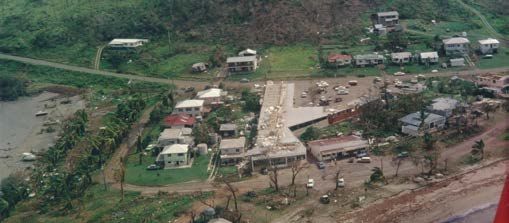
PPRR OVERVIEW CYCLONE
Disasters have a cyclic four stage lifecycle. Understanding this lifecycle helps us to be prepared for disasters,
respond safely and recover quickly and effectively.
At each stage there are different things to know and different actions we should take. These stages can change rapidly and
often overlap.
The four stages are referred to as ‘PPRR’.
PREVENTION
Prevention activities reduce the impact of disaster events through the identification of hazards.
Hazards are risks that could affect your household, causing you to evacuate or that could impact your
evacuation plans. Hazards can include having power lines near trees, living in a street with only one access point,
or having a creek behind your house. At a regional level, it also involves legislation,
land-use planning and technical solutions.
Cyclone Ului Track Map
PREPAREDNESS
Preparedness is an ongoing set of activities in which people plan, prepare/organise and train CYCLONE
for emergency situations. This includes tasks such as having an emergency kit, making an evacuation plan,
simulating disaster situations and appropriate responses, and discussing emergency preparedness What is it?
with your family, friends and neighbours.
Tropical cyclones are intense low-pressure systems that form over warm tropical waters. Cyclones are dangerous for three (3)
main reasons:
RESPONSE
Response is responding to the immediate needs of the emergency situation. • Destructive winds can cause extensive damage and can turn debris into dangerous missiles
A well-rehearsed emergency plan developed during the preparedness stage enables more effective • Heavy rainfall can produce extensive flooding and landslides
responses at all levels. • Storm tide can increase sea levels above king tide level and cause damaging waves
The severity of a tropical cyclone is described in terms of categories ranging from 1 (weakest) to 5 (strongest) related to the
RECOVERY maximum mean wind speed. See below table:-
Recovery involves activities and decision making necessary to restoring the affected area to its
previous state, often taking the opportunity to build stronger by reducing pre-disaster risks inherent Maximum Typical
Central
in the community and infrastructure. This stage often involves rebuilding, re-employment and Category Mean Wind Strongest Typical Effects
Pressure (hPa)
repair of essential infrastructure. There is also a focus on human social recovery to individual health and wellbeing. (km/h) Gust (km/h)
Negligible house damage. Damage to some crops,
1 63 - 88 < 125 > 985
trees and caravans. Craft may drag moorings
Minor house damage. Significant damage to
CLIMATE CHANGE 2 89 - 117 125 - 164 985 - 970
signs, trees and caravans. Heavy damage to some
crops. Risk of power failure. Small craft may break
moorings. (e.g. Anthony, Dylan)
Some roof and structural damage. Some caravans
Whitsunday Regional Council has a Climate Change Policy The Strategy ensures that climate change adaptation is a core 3 118 - 159 165 - 224 970 - 955
and Climate Change Adaptation Strategy 2016-2020 for the component of planning for a more resilient Whitsunday Region destroyed. Power failures likely. (e.g. Ului)
Whitsunday Region. and that is mainstreamed into Council’s functions and activities.
Significant roofing loss and structural damage.
Many caravans destroyed and blown away.
The Whitsunday Region is known to be exposed to a number of Council’s new Evacuation Maps (Storm Tide), commencing on 4 160 - 199 225 - 279 955 - 930
natural hazards, all of which are likely to be exacerbated by climate page 34, have been developed to better incorporate climate Dangerous airborne debris. Widespread power
change. Recent modelling undertaken by BoM and CSIRO shows change projections. failures. (e.g. Ada, Tracy, Larry)
that climate change is projected to affect the Whitsunday Region
Extremely dangerous with widespread destruction.
in the form of: Whitsunday Regional Council has recently employed a Manager 5 > 200 > 279 < 930
who is responsible for Climate Change planning, adaptation and (e.g. Yasi, Marcia)
· Increased temperatures and heatwave risk management.
· Changes to rainfall (including heavier extreme rainfall)
· Increased storm surge events Tropical Cyclones are referred to as ‘Severe Tropical Cyclones’ when they are producing ‘very destructive winds’ which corresponds
· Increased intensity of tropical cyclones to category 3, 4 and 5. This is also the trigger point for opening of Public Cyclone Shelters.
· Rise in sea level (leading to increased coastal inundation risk)
· Increase in extreme bushfire risk days
4 5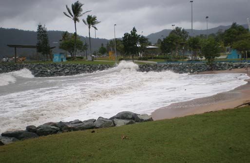
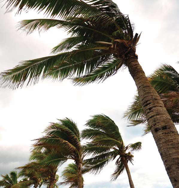
CYCLONE What are the local risks? taken with your emergency kit. Large/heavy valuables could
be protected in a strong cupboard STORM TIDE/STORM SURGE
The Whitsunday Region
• Remain indoors (with your pets). Stay tuned to your local
has a very high risk of being
radio/TV/internet for further information
impacted by cyclones during the ‘wet season’ or ‘cyclone season’
which officially runs from 1 November to 30 April (although very On warning of local evacuation
few have occurred in November). Between 2010 and 2016, four (4)
Based on predicted wind speeds and storm surge heights,
cyclones passed directly through the Whitsunday Region, making
evacuation may be necessary. Official advice will be given on
us the most frequently impacted Queensland local government
local radio/TV/internet regarding safe routes and when evacuation
area during this period.
should occur.
What should I do?
• Wear strong shoes (not thongs) and tough clothing for
The information in this checklist was prepared by Emergency protection
Management Australia in consultation with State/Territory • Lock doors; turn off power, gas, and water; take your
Emergency Services to help protect you and your property. evacuation and emergency kits
• If evacuating inland (out of town), take pets and leave early to
Before the cyclone season avoid heavy traffic, flooding and wind hazards
• If evacuating to a public cyclone shelter in Bowen or Proserpine Coral Esplanade, Cannonvale Beach
• Check to see if your home has been built to cyclone standards
or a higher location, follow Police and State Emergency
(generally houses constructed after 1982)
Services directions
•
•
Know your Evacuation Zone (Storm Tide). Refer to page 32
Check that the walls, roof and eaves of your home are secure
• If going to a public cyclone shelter, take your own food and STORM TIDE / STORM SURGE • Consider and identify your evacuation and shelter options
water and essential items only. Please refer to pages 28-30
• Trim treetops and branches well clear of your home When a cyclone threat develops, keep listening to official warnings
• Leave pets protected and with food and water What is it?
• Preferably fit shutters, or at least metal screens, to all glass areas issued by the Bureau of Meteorology. They will advise if high tides
• Clear your property of loose material that could blow about and As the cyclone approaches A storm surge is a rise above the normal water level along a and coastal storm tide is expected.
possibly cause injury or damage during extreme winds shore resulting from strong onshore winds and / or reduced
• isconnect all electrical appliances. Listen to your battery
D atmospheric pressure. The combination of storm surge and Listen to official warnings from the Whitsunday Local Disaster
• In case of a storm surge/tide warning, or other flooding, know
radio for updates normal (astronomical) tide is known as a ‘storm tide’. The worst Coordination Centre which will advise of the evacuation of any
your nearest safe high ground and the safest access route to it
• Stay inside and shelter in the strongest part of the building impacts occur when the storm surge arrives on top of a high storm tide colour zones.
• Prepare an emergency kit as shown on page 20
and keep well clear of windows, i.e. cellar, internal hallway or tide and when this happens, the storm tide can reach areas that
• Keep a list of emergency phone numbers on display on page 20
bathroom. Keep evacuation and emergency kits with you might otherwise have been safe. On top of this are pounding
• Check neighbours, check neighbours, especially if elderly or if
recent arrivals
• If the building starts to break up, protect yourself with
waves generated by the powerful winds. Useful Links:
mattresses, rugs or blankets, under a strong table or bench or Whitsunday Regional Council Evacuation Zone (Storm
Monitor cyclone potential throughout the season
www.bom.gov.au
hold onto a solid fixture, e.g. a water pipe What are the local risks? Tide) video - www.whitsunday.qld.gov.au/evacuation
• Beware the calm ‘eye’. If the wind drops, don’t assume the
The Whitsunday Region has a very high risk of being impacted by
When a cyclone watch is issued cyclone is over; violent winds will soon resume from another Bureau of Meteorology -
cyclones including storm tide during the cyclone season which
direction. Wait for the official ‘all clear’ http://www.bom.gov.au/qld/warnings/
• e-check your property for any loose material and tie down (or
R officially runs from 1 November to 30 April. Also, the Whitsunday
• If driving, stop (handbrake on and in gear) - but well away from
fill with water as last resort) all large, relatively light items such Region is largely a coastal and island based community, with
the sea and clear of trees, power lines and streams. Stay in
as boats and rubbish bins several low-lying areas at significant risk from storm tide. Inland
the vehicle
• Fill your fuel tanks and any jerry cans. Check your emergency areas such as Collinsville are not at risk from storm tide.
kit and fill water containers After the cyclone
• Ensure household members know which is the strongest part In January 2014, Cyclone Dylan (Category 2) crossed the
• Don’t go outside until officially advised it is safe
of the house and what to do in the event of a cyclone warning Whitsunday coast near Hydeaway Bay, also on the day of a king
• Check for gas leaks and fallen power lines. Don’t use electric
or an evacuation tide. The day prior and the day that the cyclone crossed the
appliances if wet
• Tune to your local radio/TV/internet for further information and coast, widespread storm tide of up to 0.5metres of water above
• Listen to local radio for official warnings and advice
warnings the usual king tide level was experienced across the region,
• If you have to evacuate, or did so earlier, don’t return until
• Check that neighbours are aware of the situation and are
inundating streets and foreshores across Bowen, Cannonvale,
advised. Use a recommended route and don’t rush
preparing Airlie Beach and Wilson Beach.
• Be aware of damaged power lines, bridges, buildings, trees,
When a cyclone warning is issued and do not enter floodwaters
The Whitsunday Disaster Management Group initiated over
• Heed all warnings and don’t go sightseeing. Instead, check
Depending on official advice provided by your local authorities as 100,000 Emergency Alert text messages and phone calls
and offer help to neighbours and other friends and family
the event evolves; the following actions may be warranted to warn the community of the risk, as worst case scenario
• Don’t make unnecessary telephone calls
• If requested by local authorities, collect children from school or predictions of the storm tide from the Bureau of Meteorology
childcare centre and go home Note: Managers of resorts, hotels, motels, and caravan parks should take were between 1.2m and 2.0m across the Whitsunday coast
• Park vehicles under solid shelter (hand brake on and in gear) steps to ensure visitors are aware of the dangers and know what to do in depending on the time and location of the cyclone’s crossing.
the event of a cyclone. Residents should monitor official advice provided Fortunately the cyclone crossed at low tide
• Put wooden or plastic outdoor furniture in your pool or inside
through the Bureau of Meteorology, radio and the Whitsunday Disaster &
with other loose items Emergency Information Facebook Page.
• Close shutters or board up or heavily tape all windows (tape What should I do?
does not strengthen windows, but minimises the glass shatter You need to plan well ahead of time.
Useful Links:
if broken). Draw curtains and lock doors • Know your Evacuation Zone (Storm Tide). Please refer to
Bureau of Meteorology - www.bom.gov.au/cyclone/
• Pack an evacuation kit of warm clothes, essential page 32
BOM Weather app - http://www.bom.gov.au/app/
medications, baby formula, nappies, valuables, important • Be ready to evacuate and have an Evacuation Kit. Please Cannonvale Boardwalk
papers, photos and mementos in waterproof bags to be refer to page 21
6 7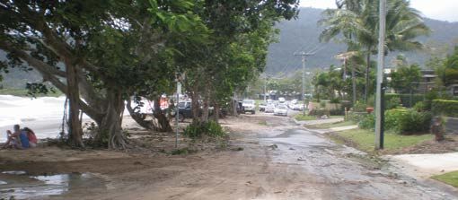
SEVERE THUNDERSTORM/                                                                                                                                                                                                                                          FLOOD
    SEVERE WEATHER WARNINGS

                                                                                                                  Airlie Beach
                                                                                                                                                                                                                                                Cyclone Ita - Bowen

    SEVERE THUNDERSTORM / SEVERE WEATHER WARNINGS
                                                                                                                                       FLOOD
    What is it?                                                       What should I do?                                                What is it?                                                           Roads
    Severe thunderstorm and severe weather warnings are issued        If weather conditions indicate the possibility of storms, make
    by the Bureau of Meteorology. In active months, especially        sure you’ve completed the following precautions:                 A flood occurs as a result of excess rainfall in a river, creek or    Regularly during the wet season and other significant rainfall
    November to April, many of these warnings are issued for parts                                                                     storm water drainage catchment that exceeds the ability of the        events, there are many roads throughout the Whitsunday Region
    of the Whitsunday Region, often multiple times each day.          •   Ensure your Emergency Plan is up-to-date. Please refer       catchment to contain the rainfall in the natural or man-made water    which are subject to localised flooding.
    Severe thunderstorms and severe weather rarely leads to the           to page 18                                                   flow paths. Flooding can be minor such as road inundation, or
    activation of the Whitsunday Disaster Management Group or         •   Ensure you Emergency Kit is fully stocked. Please refer to   moderate to major when houses become inundated or areas               Road closure hot spots include but are not limited to:
    the Whitsunday Disaster Coordination Centre. Although these           page 20                                                      evacuated.
    events can be dangerous and it is important that the community    •   Check that your insurance is up-to-date and covers                                                                                 •  Bruce Highway, Merinda
    is warned and aware of the risks and take the necessary               damage to home and contents in case of severe storm          What are the local risks?                                             •  Bruce Highway, South of Bowen
    precautions, they rarely result in a large scale disaster event   •   Ensure your yard and outdoor areas are free from loose                                                                            •  Bruce Highway, Myrtle Creek
    that requires a significant coordinated response and recovery          items such as patio furniture, garden tools and rubbish     The Whitsunday Region has a high risk of being impacted by            •  Bruce Highway, near Dingo Beach turnoff
    effort.                                                           •    Trim overhanging branches, clean out gutters and ensure     flooding primarily during the ‘wet season’ which officially runs      •  Bruce Highway, Goorganga Plains, south of Proserpine
                                                                           roof is in good condition                                   from 1 November to 30 April. Flooding may or may not be               •	Shute Harbour Road – along Hamilton Plains and Myrtle
    What are the local risks?                                         •    Move vehicles under shelter or cover with firmly tied      associated with cyclones or severe weather events and can                Creek – between Airlie Beach and Proserpine
                                                                            tarpaulins / blankets                                      occur at any time of the year.                                        •	Crofton Creek on Gregory-Cannonvalley Road in
    Severe Thunderstorms                                                                                                                                                                                        Strathdickie
    While the Whitsunday Region experiences many thunderstorms,       When you hear a severe storm or severe weather                   Council’s Natural Disaster Risk Management Report advises
    more intense thunderstorms are referred to as severe              warning:                                                         that flooding in the Whitsunday Region can result from one or         Official Road Closures
    thunderstorms. Severe thunderstorms can cause significant                                                                          more of the following, which may occur in combination:                Official road closures are listed on the State Government website
                                                                      •   Stay tuned in to warnings                                                                                                          www.131940.qld.gov.au
    localised damage due to damaging wind gusts, large hail,
                                                                      •   Contact family to make sure everyone is aware of the         •   Flooding in the catchments of the major river systems in
    tornadoes and flash flooding.
                                                                          warning                                                          the region, namely the Don River; the Proserpine River and
                                                                      •   Shelter and secure animals                                       its tributaries; the Gregory River; and the Andromache/
    The Bureau of Meteorology issues Severe Thunderstorm
                                                                      •   Disconnect all electrical items, aerials and computer            O’Connell Rivers
    Warnings to alert communities of the threat of these more
                                                                          modems                                                       •   Major flooding in the Don River occurs frequently and minor
    dangerous thunderstorms.
                                                                                                                                           flooding in Euri Creek and the Elliot River to the north of
                                                                      During a severe storm or severe weather warning:
    Severe Weather                                                                                                                         Bowen
                                                                      •   Stay tuned in to warnings                                    •   Flash flooding following intense short period rainfall in
    Severe weather warnings are provided for potentially hazardous
                                                                      •   Consider activating your Emergency Plan                          smaller catchments such as Airlie Creek and Campbell
    or dangerous weather that is not solely related to severe
                                                                      •   Stay inside and shelter well clear of windows, doors and        Creek, which creates localised high risk due to high velocity
    thunderstorms, tropical cyclones or bushfires.
                                                                           skylights                                                       flows and the lack of warning time
                                                                      •    If driving, stop clear of trees, power lines and streams    •   In the case of flooding associated with tropical cyclones,
    The Bureau of Meteorology issues severe weather warnings
                                                                                                                                            flooding of low lying areas close to the shore line can result
    whenever severe weather is occurring in an area or is expected
                                                                                                                                            from a combination of high tide and storm surge (together
    to develop or move into an area. The warnings describe the area   Useful Links:                                                         referred to as storm tide)
    under threat and the expected hazards. Warnings are issued        Bureau of Meteorology
    with varying lead-times, depending on the weather situation,      http://www.bom.gov.au/qld/warnings/
    and range from just an hour or two up to about 24 hours.

8                                                                                                                                                                                                                                                                            9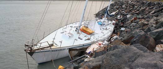
FLOOD risk entirely. Significant rain events when the dam is full or near
capacity, or significant rain events within the 25% catchment
BUSHFIRES / GRASSFIRES
area below the dam, could result in a flood event that affects the
Flood Cameras Proserpine town and surrounds.
Whitsunday Regional Council has installed a flood camera at Whitsunday Regional Council is currently investing in upgrading
Hamilton Plains on Shute Harbour Road between Proserpine and the rainfall and river gauge network within the Proserpine
Airlie Beach. The images of this well-known flooding hot spot catchment to improve early information and warnings of
are taken every 15 minutes throughout the day and uploaded potential flood events.
to Council’s website - www.whitsundayrc.qld.gov.au/Flood-
Camera. These images enable the community to better plan Eungella Dam
and prepare their movements in this area during flood events
The Eungella Dam is situated in the Mackay Region but its water
and avoid driving through flood water. For official road closure
is released into the Whitsunday Region flowing down the Broken
information visit www.131940.qld.gov.au and remember, if it’s
River and into the Burdekin catchment. A significant flood event
flooded forget it.
or dam failure has the potential to affect some cattle stations and
roads in the western area of the region.
Council is intending on installing another flood camera at Crofton
Creek on Gregory-Cannonvalley Road in 2017.
Burdekin Falls Dam
Don River Flood Warning system The Burdekin Falls Dam is located on the north-western
Whitsunday Regional Council in cooperation with the Bureau
boundary of the Whitsunday Region. BUSHFIRES / GRASSFIRES
A significant flood event or dam failure has the potential to
of Meteorology owns a series of river and rainfall alert stations affect some cattle stations and roads in the north and north-
throughout the Don River catchment near Bowen. This enables What is it?
western area of the region.
the earliest warning possible of potential rainfall and river rises What should I do?
that could lead to a flood event. Council also operates a Don Bushfires and grassfires are common throughout Australia.
What should I do? • It is important to include wildfire in your household
River Flood telephone call-up list. When the Don River is on Grassfires are fast moving, passing in five to ten seconds emergency plan and consider completing a wildfire
Flood Watch or Flood Warning and is at risk of a moderate or and smouldering for minutes. They have a low to medium survival plan as part of your household preparations. For
• Pay attention to weather patterns and weather forecasts
major flood event, Council activates the telephone call-up list intensity and primarily damage crops, livestock and farming information on how to create a Bushfire Survival Plan
• During flooding, stay away from rivers, creeks and drains
and a voice recorded message provides a brief overview of the infrastructure, such as fences. Bushfires are generally slower visit https://www.ruralfire.qld.gov.au/BushFire_Safety/
• Have an evacuation plan and emergency / evacuation kits
flood risk. moving, but have a higher heat output. This means they pass Pages/Create-your-bushfire-survival-plan.aspx
(see pages 18-21)
in two to five minutes, but they can smoulder for days. Fire in • Keep an eye on the Rural Fire Service website
• Plan which indoor items you will raise or empty if water
If you may be affected by a Don River flood event, you can be the crown of the tree canopy can move rapidly. (Definition from www.ruralfire.qld.gov.au when hot, dry conditions exist;
threatens your home
added to this list by phoning Council or e-mailing Geoscience Australia). • Keep grass cut and vegetation clear of the property
• Stay tuned into warnings and updates
info@whitsundayrc.qld.gov.au • Never drive, ride or walk through flood waters • Don’t dump garden rubbish in neighbouring reserves or
What are the local risks? bush areas
• Evacuate if threatened by flood water and safe to do so, or
Dams if advised to evacuate by authorities Bushfires can happen here although we live in the Wet Tropics • Move flammable items away from the house, e.g.
There are three (3) referable dams that can potentially impact with humid conditions. They may be started through arson woodpiles, boxes, hanging baskets, garden furniture
land within the Whitsunday Region should they be subject to a (deliberately lit), carelessness (e.g. discarded cigarettes, sparks • Keep access ways to the property clear for fire trucks
Useful Links:
flood event or dam break. All three (3) dams of interest to the from machinery, unattended fires), lightning, as the result of an • When warnings are given, act immediately on the
Bureau of Meteorology
Whitsunday community are owned and operated by SunWater. accident or very rarely, as the result of a controlled/prescribed instructions provided. Don’t wait. Leave when advised,
http://www.bom.gov.au/australia/flood/otherlinks.shtml
They are discussed briefly below. burn. If you light a fire, on purpose or accidentally, you are even if it feels safe where you are at the time. Take your
http://www.bom.gov.au/water/floods/floodWarningServices.shtml
responsible for controlling it. household emergency kit with you.
State Government - www.131940.qld.gov.au
Peter Faust Dam Council - www.whitsundayrc.qld.gov.au/Flood-Camera
If there is a long spell of hot, dry weather and it’s windy, the
The Peter Faust Dam is located approximately 25km west of
fire risk increases. Generally the fire season in Central and
Proserpine township. It was built in 1990 on the Proserpine
North Queensland is through the winter (dry season) and spring Useful Links:
River mainly for irrigation and urban water supply, however the
months. Information about fire risk and fire danger periods will For more information, visit Rural Fire Service -
dam also provides flood mitigation to Proserpine and surrounds.
be issued by fire authorities as required. www.ruralfire.qld.gov.au or read other PREPARE.ACT.
SunWater own and manage the dam and are responsible for
SURVIVE. resources
the dam Emergency Action Plan. The population at risk from a
In the Whitsunday Region, there are extensive areas of medium
sunny day failure is over 5,000 people and for a flood failure, it
bushfire hazard and several smaller areas or high bushfire
is over 1,500 people in Proserpine and surrounding areas. The
hazard.
dam captures approximately 75% of the catchment area.
You don’t have to live in the bush to be threatened by bushfire,
In conjunction with the dam (but prior to), a levee and spillway
just close enough to be affected by burning material, embers
system has been built on the Proserpine River downstream of the
and smoke.
dam to protect valuable cane lands and the Proserpine town which
are maintained by the Whitsunday Rivers Improvement Trust.
The dam and levee system combine to significantly reduce the Cyclone Ita - Bowen
flood risk to Proserpine and surrounds but do not eliminate the
10 11
BUSHFIRES / GRASSFIRES                                                                                                                                                                             HEATWAVE

                                                                                        HEATWAVE
                                                                                        What is it?                                                           Useful Links:
                                                                                        The Bureau of Meteorology defines a heat wave as three days           Queensland Health
                                                                                        or more of high maximum and minimum temperatures that is              https://www.health.qld.gov.au/disaster/heat/
                                                                                        unusual for that location.
                                                                                                                                                              Bureau of Meteorology:
                                                                                        What are the risks?                                                   http://www.bom.gov.au/australia/heatwave/
                                                                                        The bulk of heatwaves at each location are of low intensity,
                                                                                        with most people expected to have adequate capacity to cope
                                                                                        with this level of heat. Less frequent, higher intensity heatwaves
                                                                                        are classified as severe and will be challenging for some more
                                                                                                                                                              Bowen Waterpark
                                                                                        vulnerable people, such as those over 65, pregnant women,
                                                                                        babies and young children, and those with a chronic illness.
                                                                                        Even rarer and exceptionally intense heatwaves are classed as
                                   BUSHFIRE WARNINGS                                    extreme and will impact normally reliable infrastructure, such as
                                                                                        power and transport. Extreme heatwaves are a risk for anyone
                                                                                        who does not take precautions to keep cool, even those who
                                                                                        are healthy.

                                                                                        Severe and extreme heatwaves have taken more lives than any
                                                                                        other natural hazard in Australia’s 200 year history. For example,
                                                                                        during the 2009 Victorian bushfires, 173 people perished as a
                                                                                        direct result of the bushfires, however 374 people lost their lives
                                                                                        to extreme heat in Victoria in the heatwave before the bushfires.

                                                                                        What should I do?
                                                                                        It is prudent to prepare and modify your behaviour when extreme
                                                                                        heat occurs. You may be more vulnerable to severe heat if you
                                                                                        are over the age of 65, particularly if you have pre-existing

                                                                 EMERGENCY
                                                                                        medical conditions. It is best to consult your doctor if you are
               ADVICE                 WATCH AND ACT               WARNING
                                                                                        unsure. Stay healthy in the heat. Find out who is at risk and how
                                                                                        you can prepare for and cope during a heat event and what to
                                                                                        do for heat-related illnesses.
          Monitor conditions and      Conditions are changing.    You are in danger.
           review your Bushfire        Start taking action and   Act on your Bushfire   For information on staying healthy in the heat or heat related
               Survival Plan.           follow your Bushire       Survival Plan now.    illnesses, please visit
                                            Survival Plan.                              https://www.health.qld.gov.au/disaster/heat/heat-wave.asp

                                                                                        Information provided by Queensland Health

12                                                                                                                                                                                                                 13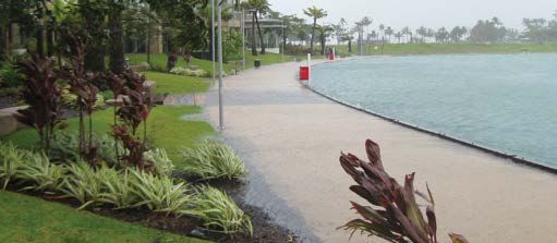
What
should I do?
TSUNAMI
Before an earthquake (now)
• Find out how and where to turn off power, gas and water
• Plan with your family (or household) where you will meet if
separated
• Know your safe areas during an earthquake
• Check your insurance policy to make sure it is adequate
and that you are covered for damage caused by
earthquakes
During an earthquake
• If indoors - stay there (clear of falling debris outside)
• Keep clear of windows, chimneys and overhead fittings.
Shelter under and hold onto a door frame, strong table
or bench Hardy Reef
• In high-rise buildings, stay clear of windows and outer
walls. Shelter under a desk near a pillar or internal wall
EARTHQUAKE • Do not use elevators
TSUNAMI
• In crowded buildings, do not rush for doors, but move
What is it? clear of overhead fittings and shelves
Earthquakes are the vibrations caused by rocks breaking under • If outside—keep well clear of buildings, overhead What is it? Follow their instructions immediately.
stress. The underground surface along which the rock breaks structures, walls, bridges, powerlines, trees, etc
• On a city street, shelter from falling debris under strong Tsunami (pron: ‘soo-nar-me’) is a Japanese word; ‘tsu’ meaning The following are natural signs of a tsunami that you may,
and moves is called a fault plane. Earthquakes in Australia
archways or doorways of buildings. Don’t go under harbour and ‘nami’ meaning wave. The phenomenon is usually but not always, experience when you are near the coast in
are usually caused by movements along faults as a result of
awnings as they may collapse associated with earthquakes, landslides or volcanic eruptions Australia or overseas. If you notice any of these warning signs
compression in the Earth’s crust. The size or magnitude of
• If in a vehicle—stop in an open area until the shaking in, or adjacent to oceans, and results in sudden movement take action.
earthquakes is determined by measuring the amplitude of the
seismic waves recorded on a seismograph and the distance stops of the water column. Until recently tsunami were called tidal
• Beware of damaged powerlines and road damage, waves, even though the event has nothing to do with tides. • A shaking of the ground in coastal regions may reflect the
of the seismograph from the earthquake. These are put into
including overpasses and bridges occurrence of a large undersea earthquake nearby that
a formula which converts them to a magnitude, which is a
measure of the energy released by the earthquake. For every unit • Listen to your car radio for warnings before moving What are the local risks? may generate a tsunami
• As a tsunami approaches shorelines, the sea may, but
increase in magnitude, there is roughly a thirty-fold increase in
After an earthquake There is little recorded history of tsunami in Australia, possibly not always, withdraw from the beach (like a very low and
the energy released. For instance, a magnitude 6.0 earthquake
because Australia has a relatively short history. There is fast tide) before returning as a fast-moving tsunami
releases approximately 30 times more energy than a magnitude • Turn off electricity, gas, and water. Do not light matches evidence that the Australian coast may have experienced large • A roaring sound may precede the arrival of a tsunami
5.0 earthquake, while a magnitude 7.0 earthquake releases until after you have checked for gas or fuel leaks
approximately 900 times (30x30) more energy than a magnitude tsunami during the past few thousand years, even within areas
• Check for injuries and apply first aid. Do not move of the Great Barrier Reef. The Great Barrier Reef however is What should I do if I notice the warning signs or hear a
5.0. Earthquake magnitude was traditionally measured on the seriously injured people unless they are in immediate expected to provide a level of protection to the Whitsunday warning from my local emergency services?
Richter Scale. It is often now calculated from seismic moment, danger
which is proportional to the fault area multiplied by the average Region in the event of a tsunami in the Pacific Ocean.
• Check for broken water, sewerage or electrical mains • If you are at the beach, immediately move inland or to
displacement on the fault. The focus of an earthquake is the • Do not use the telephone immediately (to avoid The Whitsunday Disaster Management Group regularly receives higher ground
point where it originated within the earth. The earthquake congestion) unless there is a life-threatening situation information about undersea earthquakes and tsunamis around • If your boat is in deep water and offshore, maintain your
epicentre is the point on the Earth’s surface directly above the • Check for cracks and damage to your building the world. position
focus. • Evacuate the building if it is badly damaged, and be • If your boat is berthed or in shallow water, secure your
This information has been provided by Geoscience Australia. prepared for aftershocks The recent 5.8 magnitude earthquake in 2016 just off the vessel and move inland or to higher ground
• Do not waste food and water as supplies may be coast of the Whitsundays (the second largest on record • If you are on the coast and cannot move inland, seek
What are the local risks? interrupted in Queensland) was not large enough to trigger a tsunami shelter in the upper levels of a stable building
Earthquake risk in the Whitsunday Region is high in Queensland • Listen to your local radio station and heed warnings and warning. Tsunami warnings are generally only considered for • Do not return to the coast until you receive official
terms, moderate in Australian terms and low in global terms. advice on damage and service disruptions earthquakes above 6.5 magnitude. clearance
• Try to avoid driving unless in an emergency (to keep the • Continue to follow emergency services instructions
On 18 August 2016 at 2.30pm the second largest earthquake on streets free for emergency services) Some of this information has been provided by Geoscience
record in Queensland of 5.8 magnitude occurred just offshore • Do not go sightseeing or enter damaged buildings Australia. This information has been provided by the Joint Australian
within the Whitsunday Region, about 50 kms from Bowen. • Try to stay calm and help others if possible Tsunami Warning Centre.
This earthquake was felt across the entire Whitsunday Region What should I do?
and large amounts of Queensland and was followed by over
fifty (50) aftershocks. What are the warning signs of a tsunami?
Useful Links:
On 16 April 2011 a significant 5.3 magnitude earthquake Useful Links: Geoscience Australia:
The number one warning sign of a tsunami in Australia is the
Geoscience Australia - http://www.ga.gov.au/earthquakes/ http://www.ga.gov.au/scientific-topics/hazards/tsunami
occurred west of Bowen and was widely felt across the advice you may receive from the media (on radio, television or
Bureau of Meteorology: www.bom.gov.au/tsunami/
Whitsunday Region, this is one of the ten (10) largest internet) or from police and other emergency services.
earthquakes on record in Queensland.
14 15
PREVENTION AND
LANDSLIDE PREPAREDNESS
Landslide - Hideaway Bay Proserpine
LANDSLIDE DISASTER MITIGATION COMMUNITY RESILIENCE
Although most disaster events can’t be prevented, knowing Community resilience is a community’s capacity to absorb
What is it? the hazards and risks, learning lessons from past events and disturbance and respond positively to a crisis.
implementing mitigation measures can help minimise future
A landslide is the movement of rock, debris or earth down impacts from disaster events. Resilient communities are ones where residents are connected
a slope. Landslides result from the failure of the materials to one another and work together in ways that enable it to
which make up the hill slope and are driven by the force of Whitsunday Regional Council plays a major role in disaster function in the face of stress and trauma. It has the ability
gravity. Landslides are known also as landslips, slumps or mitigation activities including: to adapt to changes in the physical, social or economic
slope failure. environment and is able to learn from experience and improve
• Road network upgrades (bridges, culverts, road sealing) over time.
What are the local risks? • Drainage works (creek clearing, upgrading infrastructure,
non-return valves in low-lying coastal areas) A community’s positive response to a disaster can also allow
There are areas of the Whitsunday Region which are • Water and sewerage network improvements and us to focus on our capabilities and strengths and less on
susceptible to landslides, including areas from Cannonvale redundancy options our vulnerabilities. There is no hard and fast rule on how to
and Airlie Beach through to Shute Harbour, as well as • Foreshore protection activities (rock walls, erosion build community resilience however it is best strengthened
Hydeaway Bay. These areas have sufficient slope and prevention) continuously, not just in times of crisis.
rainfall which elevate the risk of landslides in these • Installing more disaster resilient infrastructure in lower
developed areas. risk locations For example, do you know your neighbours? Are you actively
• Educating the community about preparedness activities involved in your local community? Do you know what to do
On 30th March 2011, Hydeaway Bay was affected by before, during and after a natural disaster?
landslides. This was apparently as a result of about 600mm of rainfall in the area over three (3) day period, after an already heavy
‘wet season’.
GET READY QUEENSLAND
To see how well prepared you are, visit
In 2008, a landslide at Shute Harbour damaged half the road leading into a residential estate. When it comes to extreme weather events in Queensland, it’s
www.emergencyvolunteering.com.au and complete
not so much a matter of ‘if’ but ‘when’. The more prepared our
the Disaster Readiness Checklist.
What should I do? community is, the faster we will recover afterwards.
• Identify if your property is at risk from landslide (refer to Council’s Local Planning Instrument). The Queensland Government’s Get Ready Queensland website
http://www.whitsunday.qld.gov.au/157/Planning contains detailed information and fact sheets about what you
• Monitor environmental conditions that could increase the risk of landslides such as rainfall, erosion and earthquakes. need to know about preparing for a disaster.
• Watch for signs of creep that show an area is already moving. For example, movement of ancillary structures such as decks
and patios in relation to your house, sticking doors or windows, tilting or cracking of concrete floors and foundations, leaning Each person in the Whitsunday Region should take time to
poles, trees, retaining walls or fences.” conduct preparedness activities around the home and business
or sit down with the family to talk about your Household
Some of this information has been provided by Geoscience Australia Emergency Plan.
Visit www.getready.qld.gov.au for more information.
Useful Links:
Geoscience Australia:
http://www.ga.gov.au/scientific-topics/hazards/landslide
16 17Address Further away meeting place
Home / work phone numbers Address
PREVENTION AND
Mobile phone number Phone number PREVENTION AND
PREPAREDNESS
Email address Email address PREPAREDNESS
Out-of-town contact name
PHONE NUMBERS
HOUSEHOLD EMERGENCY PLAN
Address
Local Council (07) 4945 0200
Home / work phone numbers
Electricity provider
Mobile phone number
Local GP or doctors’ surgery
HOUSEHOLD
Email addressCONTACTS
Hospital
Name Mobile number Email address
MEETING PLACES Veterinary practice
Nearby meeting place Insurance provider
Address Childcare provider
Phone number Local primary school
Email address Local high school
Further away meeting place Workplace
EMERGENCY
Address CONTACTS Workplace
Nearbynumber
Phone contact name Bureau of Meteorology www.bom.gov.au
Address
Email address Friends
Home / work phone numbers Friends
PHONE NUMBERS
Mobile phone number Neighbours
Local Council
Email address Neighbours
Electricity provider
Out-of-town contact name
Local GP or doctors’ surgery
Address
MEDICAL
PRACTICEINFORMATION
DATES
Hospital Medication Who needs it and at what dosage?
Home / work phone numbers Three times per year
Veterinary practice
Mobile phone number 1:
Insurance provider
Email address 2:
Childcare provider
3:
MEETING PLACES
Local primary school
Nearby
Local meeting
high schoolplace SHELTER
Address
Workplace Where will we shelter if we are staying in the house? Where will our pets shelter?
Phone number
Workplace
Email address
Bureau of Meteorology
Further away meeting place
Friends
Address
Friends MAINS SERVICES
Phone number
Neighbours Locations in house, and how to switch off supply:
Email address
Neighbours Electricity:
PHONE NUMBERS
MEDICAL INFORMATION
Local Council
Medication Who needs it and at what dosage? Gas:
Electricity provider
Local GP or doctors’ surgery Water:
Hospital
Emergency
Veterinary
Police, practice
Fire and Ambulance: Phone 000 Triple Zero (112 from mobile)
State Emergency Service (SES):
Insurance provider Phone 132 500 LOCAL RADIO STATION
Childcare provider
18 Local primary school
Local high school
19PREVENTION AND PREVENTION AND
PREPAREDNESS PREPAREDNESS
EMERGENCY KIT EVACUATION KIT
Every family should have a fully stocked Emergency Kit stored safely in their home. Your Emergency Kit contains the provisions for Keep original or certified copies of these documents in your Emergency Kit. Scan copies of them and save the files on a USB
your essential needs in the event of an emergency. memory stick or CD to include in your kit. Keep all of these items in sealed plastic bags.
FOOD AND WATER Insurance papers for your house and contents,cars and for valuable items o
Range of non-perishable food items o Inventory of valuable household goods o
Bottled water o Wills and life insurance documents o
MEDICAL & SANITATION House deeds/mortgage documents o
First Aid Kit and manual o Birth and marriage certificates o
Essential medications, prescriptions and dosage o Passport / Visa details o
Toilet paper o Stocks and bonds o
Toothpaste/brush o Medicare, pension cards, immunisation records o
Soap/shampoo o Bank account and credit card details o
Personal hygiene items o A back-up copy of important computer files o
LIGHT Household Emergency Plan with emergency contact numbers o
Flashlight/torch with extra batteries o Multiple changes of clothes for all household members o
Battery powered lantern o Extra essential medicines and repeat prescriptions o
COMMUNICATIONS Extra first aid supplies, sunscreen, insect repellant o
Battery powered radio with extra batteries o Extra toiletry and sanitary supplies o
Traditional wired telephone o Pillows, sleeping bags and blankets for each household member o
Prepaid phone cards o Books and games for children o
CLOTHING AND FOOTWEAR Extra baby formula, food and nappies (if required) o
Clean clothing, hat and waterproof jacket o Valuables, photos and mementos in waterproof plastic bags o
Closed-toed shoes or boots o Extra money as cash o
TOOLS AND SUPPLIES Mobile phone, spare battery and charger o
Whistle, utility knife, duct/masking tape o
Plastic garbage bags, ties o
Safety glasses and sun glasses o
MISCELLANEOUS
Special items for infants (nappies, formula etc) o
Special items needed by elderly or people with special needs o
Spare house and car keys o
Pet food, water and other animal needs o
20 21PREVENTION AND PREVENTION AND
PREPAREDNESS PREPAREDNESS
FIRST AID KIT
Queensland Ambulance Services recommends that families include the following in their First Aid Kits:
o 1 packet of safety pins o 1 non-adhesive dressing (10 x 7.5cm)
o 1 packet of plastic strips o 1 pair stainless steel medical scissors
o 1 roll of non-allergenic tape o 2 square gauze swabs
o 2 sterile eye pads o 1 pair tweezers
o 4 triangular bandages o 1 pack (10) latex gloves
o 1 conforming cotton bandage (10cm) o 1 resuscitation mask
o 1 conforming cotton bandage (7.5cm) o 2 bottles eye irrigation (15mL) Hardy Beach Cyclone Ului
o 1 conforming cotton bandage (5cm) o 1 bottle antiseptic cream (50g)
o 1 hospital crepe bandage (10cm) o 1 wound closure steri-strip
o 1 sterile combine dressing (9 x 10cm) o 1 stainless steel splinter remover CAR AND BOAT PREPARATION
o 1 sterile combine dressing (20 x 20cm) o 1 saline sachet (30mL)
o 1 medium wound dressing (#14) o 5 alcohol swabs Cars • Check your boat is watertight
• Reduce wind loading and remove furled sails and covers,
o 2 non-adhesive dressings (5 x 7.5cm) o 1 first aid hints booklet
• Ensure your car insurance is current and that it covers bimini tops and any clears
your assets adequately
PROPERTY PREPARATION • Ensure your car is fully fuelled prior to cyclone events.
Cyclones nearly always involve power failure which
Obey
means petrol stations are unable to pump fuel unless they • Obey and follow all directions issued by the Regional
The best time to take action to prepare your home is before storm, cyclone and wet season. There are a range of activities you have an alternative power supply. Very few petrol stations Harbour Master or others as delegated
can undertake to minimise potential damage to you property. in the Whitsunday Region have a generator installed and • Do not leave your cyclone mooring until the Regional
ready to pump fuel in the event of power failure Harbour Master has given the all clear
General Maintenance If you live in a cyclone / severe storm-prone area • When severe weather warnings are issued, park vehicles • Prepare, plan and obey these simple rules and you could
• Keep your roof in good condition and check it regularly • Arrange for a professional builder to check your building under cover, away from trees, power lines and waterways prevent damage to your boat and others
• Keep gutters and downpipes clear so water can drain and identify ways you can increase the structural security • A penalty up to $15,000 is applicable for not following the
away quickly of your home to withstand high winds Boats directions of a Regional Harbour Master
• Trim trees and overhanging branches (be aware of any • Fit windows with shutters or metal screens for added
overhead powerlines) protection during high winds Maritime Safety Queensland recommends mariners plan,
• Check and fix any corrosion, rotten timber, termite prepare and obey when it comes to severe weather season. For more detailed information, please visit
infestations and loose fittings Final home preparations www.msq.qld.gov.au and obtain a copy of the Extreme
Plan Weather Event Contingency Plan for Mackay Region.
General home preparations When warnings are issued for cyclone or severe storm:
• Ensure your home, contents and car insurance is current • Disconnect electrical appliances and external television / • Get a copy of the Extreme Weather Event Contingency
and adequate. Check your policy includes debris clean radio aerials and turn off electricity and gas main supplies Plan for your area and read it
up and removal • Secure outdoor furniture and garden items • Explore your suggested shelter area or inlet before
• Identify your strongest room to shelter in during severe • Fill buckets and bath with clean water in case of cyclone season starts
storm or cyclone interruptions to water supply • Update your contact details with the authorities.
• Identify where and how to turn off the main supply for • Close windows with shutters or tape windows with strong • Organise options to move your boat if you will be away
water, power and gas tape and draw curtains during severe weather season
• Have items on hand, such as water storage containers, • Keep a record of emergency telephone numbers handy
spare fuel for your vehicle (ensure you store it safely), When warnings are issued for flood: (for example, Regional Harbour Master, Volunteer Marine
camp stove and fuel for cooking without power • Disconnect electrical appliances Rescue organisations, Queensland Police Service)
• Move outdoor equipment, garbage, chemicals and
If you live in a flood-prone area poisons to a higher location Prepare
• Understand your risk • Empty and raise freezers / refrigerators and stack or
• Store all poisons and garden chemicals well above move furniture, valuables and electrical items off-site • Know when and where your vessel needs to be during an
ground level and out of reach of children • Sandbag internal drains and toilets to prevent sewage evacuation
• Identify indoor items you will need to raise or empty if backflow • Have plenty of line to secure your boat (rope has more
flood threatens • Move livestock, plant and feed to higher ground ‘give’ than chain)
• Consider alternatives to carpet and relocate power- • Secure loose articles below deck
points to well above previous flood levels (using a • Secure all hatches
licensed contractor)
22 23PREVENTION AND SES
PREPAREDNESS
Bowen
PET EMERGENCY PLAN
Pets are special and they are your responsibility. It is up to • Secure animals inside before an emergency event, so
you to prepare for the safety and welfare of your pets in the they do not run away. Never leave an animal tied-up
case of an emergency. Individual needs will vary and you will or chained without shelter or bedding. Never leave an
need to decide on the best plan for your circumstances and animal in a motor vehicle.
the options available to you. • Should your pet be different - such as aquarium fish,
reptiles, small livestock etc you may have to make special
Cyclone Shelters arrangements in advance of any emergency situation.
Cyclone Ului
Contact specialised agencies such as Department of
Domestic pets and other animals will not be allowed in the Agriculture and Fisheries, the RSPCA, or your local pet
cyclone shelters and you will need to make other arrangements shop or animal’s veterinarian for specialised advice in
for sheltering your pets prior to the cyclone season. Please planning for emergencies. Flood Storm Emergency – Call 132 500 Emergency Sand Stockpiles and Sand Bagging
note: trained assistance animals are permitted to enter the
shelter and stay with the owners. Boarding Kennels Life Threatening Emergency – Call 000 To encourage residents to become self-reliant and to lessen
requests for assistance to the SES (who are all volunteers),
Temporary Animal Shelters Bowen Pet Motel 07 4786 1869 Whitsunday Regional Council, in cooperation with the State Whitsunday Regional Council provides three (3) public
Government, supports local State Emergency Service (SES) access emergency sandbagging stockpiles in the urban area.
There are currently no temporary animal shelters in the Whitsunday Pet Resort 07 4946 1077 with the supply of land, buildings, vehicles and operational These stockpiles are monitored by the SES and replenished
Whitsunday Region during times of major emergencies or resources. by Council when cyclones or significant flood events are
disasters. Pet owners are encouraged to take all the necessary threatening.
steps to have a plan in place early. Veterinarians Local SES volunteers provide support to the entire Whitsunday
Region across a range of services including:- These sand stockpiles are located at:-
Ensuring safety for your pets Whitsunday Veterinary Surgery 07 4946 1028 • Storm response • Proserpine SES Shed,
• Search and rescue 43-45 Hinschen Street, PROSERPINE
Here are some basic tips to be applied to household pet Proserpine Vet Surgery 07 4945 1878 • Vertical rescue • Cannonvale SES Shed,
emergency planning: • Boat rescue 22 Schnapper Street, CANNONVALE
Orchid Valley Veterinary Surgery 07 4946 1631 • Support to other emergency service agencies at • Bowen Council Depot,
• Properly identify your pets including registration and/ emergency incidents 181 Richmond Road, BOWEN
or micro chipping and ensure your pet has a tag. Bowen Veterinary Clinic 07 4786 4864
Remember, telephone lines may be down during a The SES has operational bases in Bowen, Proserpine,
disaster and it is important that any registered method Brolgas Rest Veterinary Surgery 07 4786 3166 Cannonvale and Dingo Beach. Locally based resources
includes your current address. include:-
• Prepare a pet emergency kit that is easily accessible. The • Seven (7) SES 4WD vehicles
kit should include medications, medical and vaccination • Five (5) SES boats
records, vet details, sufficient food and bottled water, • One (1) SES all-terrain vehicle (ATV)
can opener, a familiar pet blanket, bedding or toy, a • SES Storm damage trailers
secure pet carrier, leash or harness to move animals to
safety and also consider your animal’s sanitation needs. The SES can call upon additional resources and support from
across Queensland when required.
If you are interested in joining the SES or learning more, visit:
http://www.emergency.qld.gov.au/ses/
24 25You can also read