Guide to disaster management measures - (technologies, know how, infrastructure, institutions etc. )
←
→
Page content transcription
If your browser does not render page correctly, please read the page content below
Guide to disaster management measures
(technologies, know‐how, infrastructure, institutions etc. )
in Japan
Structural and non‐structural measures : Japanese solutions for disaster
management challenges in your country

Cabinet Secretariat, Government of Japan
Disaster Management Bureau, Cabinet Office, Government of Japan
This guide describes experience and knowledge of Japan according to the process of disaster management,
including preparedness, response, recovery and reconstruction, focusing on necessary actions for disaster risk
reduction and possible technologies that Japan could provide. Please use this brochure for considering possible
collaboration from Japan to enhance disaster management.

                                                              Early warning
Hazards                                                                                  Reponses
                                                       Early warning                                            Support affected
                                                                                                                people
                                                          Evacuation order
                                                                                       Collect damage information
                   Vulnerability of        Preparedness
 Earthquake        communities                                                Disaster        Secure logistic routes
                                   <Reduce damage>                                                                          Assess housing damage
  Volcano                         Hazard map
                                                                                                        Recover utilities
  eruption
                                  Disaster Management Plan
                                  Business continuity plan                                                 Dispose disaster waste
  Typhoon                                                                     Asses and improve
                                      Risk education
Torrential rain                                                                                  Recovery and reconstruction
                                      <Prevent damage>
                                                                                                Recovery plan
 Heavy snow                             Preventive infrastructure for
                                        national land preservation                Reconstruction Plan
   Tornedo                                      Disaster management center                                         Temporary housings
                                                                                    Financial support
                                                    Anti‐earthquake structure
             etc        Human resource
                        development                     Meteorological and terrestrial Recovery of communities
Climate change                                          phenomena observation/info share

                                                                                                                                                    1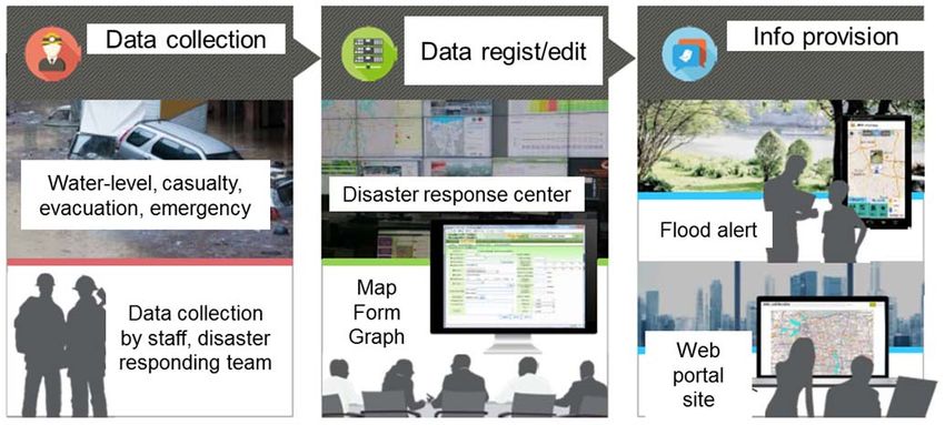
Disaster management measures in Japan                                                 Collaboration for:
   (technologies, know‐how, infrastructure, institutions etc. )                           - Earthquake/Tsunami
                                                                                          - Meteorological disaster
                                                                                          - Any types of disasters
           【Challenges in each phrase】                                 【Examples of possible collaboration from Japan】
Preparedness
A. Planning                                                          A‐1 Preparation of disaster risk reduction plans and
  ・Develop comprehensive and long‐term plans for disaster risk       business continuity plan
reduction                                                            A‐2 Introduce concepts of disaster risk reduction to master
  ・Measures based on disaster risks and vulnerability of national    plans including city planning
land, and social and economical system                               A‐3 Hazard mapping
                                                                     A‐4 Establishing a national resilience plan

B. Investment
  ・Risk‐resilient critical infrastructure
  ・Develop systems for constant monitoring/information service       B‐1 Risk‐resilient critical infrastructure
of earthquake and Tsunami                                            B‐2 Earthquake observation equipment
  ・Promote seismic reinforcement for houses/buildings and            B‐3 Seismic reinforcement/quake‐proof technologies
infrastructures                                                      B‐4 Meteorological and hydrological observation
  ・Develop systems for constant monitoring/information service       instruments
of weather and river level                                           B‐5 Water and disaster management
  ・Promote improvement of infrastructures to protect                 B‐6 Forest conservation works
lives/properties from flood due to typhoon/heavy rain or landslide
disasters, etc.

C. Risk education                                                    C‐1 Risk education materials, citizens empowerment,
・Raise awareness for disaster risk reduction and promote risk        training and exercise
education                                                            C‐2 Human resources development

                                                                                                                              2
Disaster management measures in Japan                                               Collaboration for:
   (technologies, know‐how, infrastructure, institutions etc. )                          - Earthquake/Tsunami
                                                                                         - Meteorological disaster
                                                                                         - Any types of disasters
           【Challenges in each phrase】                                【Examples of possible collaboration from Japan】

Early warning and Response                                          D‐1   Monitoring of Waves on Land and Seafloor (MOWLAS)
                                                                    D‐2   Satellite observation data for emergency responses
                                                                    D‐3   Early warning system (L‐Alert)
D. Emergency warning, evacuation support                            D‐4   Flood forecasting software
 ・Sharing disaster information, communicate to relevant             D‐5   Urgent earthquake detection and alarm system
organizations and citizens, early warning                           D‐6   Emergency warning broadcast system
                                                                    D‐7   Disaster information management system (DIMS)
E. Emergency rescue activities                                      E‐1   ICT disaster management unit
 ・Rescue/first‐aid/emergency medical care for life saving,          E‐2   Transportable air traffic control (ATC) tower
measures for evacuation sites, providing relief supplies            E‐3   Drain pump car
                                                                    E‐4   Remote‐operated equipment, unmanned construction

Recovery and Reconstruction
                                                                    F‐1 Assistance for formulation of rehabilitation and
                                                                    recovery master plan
 F. Smooth recovery and reconstruction                              F‐2 Disaster waste management
 ・Assistance for formulation of rehabilitation and recovery plan,   F‐3 『JOEN』 ~Salt removal work from farmland~
 support for livelihood                                             F‐4 Reconstruction of infrastructure ‐based on build back
                                                                    better(BBB)concept
                                                                    F‐5 Support for house reconstruction ‐based on build back
                                                                    better(BBB) concept
                                                                    F‐6 Support for livelihood recovery considering victims ‐
                                                                    based on build back better(BBB) concept

                                                                                                                           3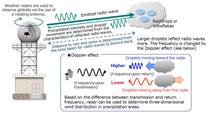
Any types of disasters
A Planning Develop comprehensive and long‐term plans
for disaster risk reduction(DRR)
A‐1 Preparation of DRR Plans and Business Continuity Plan(BCP)
Thailand・「Project on Capacity Development in -DRR White Paper
Disaster Risk Reduction」(Technical Cooperation) -National DRR Plans
Through strengthening the capacity and functions of the central -GIS for hazard information
DRR agencies, Japan supports formulation of the national and -Materials for Trainers Training
local DRR strategies and disaster risk maps, thereby improving -Guidebooks for Community based DRR
their capacity to mitigate, prepare and respond to disaster. -Guidelines for DRR Education
Photo: DRR White Paper in Thailand
Asia-Pacific Climate Change Adaptation Information
Platform(AP-PLAT)
Provide future climate‐related risk data and adaptation
information based on scientific knowledge
Contribute for formulation of the DRR planning and BCP in
developing countries.
* AP‐PLAT has been developing aiming to completely establish by 2020.
Technical assistance for local communities to prepare flood
disaster contingency plans (ICHARM)
ICHARM provides technical assistance for Calumpit, a local town
in the Pampanga River basin of the Philippines, to develop disaster
contingency plans using flood hazard maps through participation
of community members.
4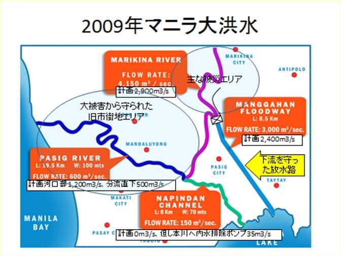
Any types of disasters
A Planning
Measures based on disaster risk and vulnerability of assessment of
national land, and social and economical system
A-2 Introduce Concepts of DRR to Master Plans Including City Planning
Multipolar
Overconcentrated decentralized
Support for Planning Including structure structure
Master Plans (Technical Cooperation) Over-
Propose
Central Central Preferable
urban
crowded
urban a multipolar
district Sub- district
center
Sub-
decentralized
When supporting preparation of urban center
urban structure
Sub-
vision, in addition to analysis of center
Sub- with high tolerance
center
disaster risks, propose reduction of to disasters
risks caused by disaster in urban
- Too much concentration - Decentralize urban functions
structure or improvement of drainage Evaluation for area - Vulnerability of - Secure redundancy for a traffic system
facilities. characteristics of flooding transferring/transporting
at a time of disaster
A‐3 Hazard Mapping Good Practice of Developing Hazard Maps
Based on the lessons from past tragedies such as Chile Tsunami in 1960 and
Support for Hazard Map Development the Great East Japan Earthquake in 2011, Japan has developed Tsunami
(Technical Cooperation) damage estimation methodologies and risk assessment based hazard map,
then support to develop Tsunami resilient societies in the world.
Japan supports developing countries to be disaster‐
resistant societies through the development of hazard
mapping based on damage estimation methodology and
risk assessment.
Technical assistance for Myanmar’s major cities (e.g.,
Yangon) to create flood hazard maps (ICHARM)
Tsunami Hazard Mapping Tsunami Inundation in Chile in 2010
When the Tsunami occurred after M8.2 earthquake in Chile on April
Technical assistance for Calumpit, the Philippines, to
2, 2014, the number of victims was minimized (6 persons) as a result
create flood risk maps by linking the height of structures
of utilizing knowledge from past technical cooperation from Japan.
and the propagation of floodwaters (ICHARM) 5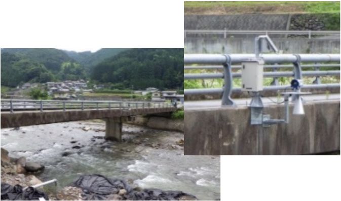
Any types of disasters
A Planning
Measures based on disaster risk and vulnerability of assessment of
national land, and social and economical system
A‐4 Establishing a National Resilience Plan
Support of Establishing National Resilience Plan,
Including Regional Plan, such as Provide of
Know-how
( Seminars, Workshops, Training and etc. by the
Cabinet Secretariat of Japan)
Provide know‐how on establishing plan to national
or local government officials
• Method of vulnerability assessment of
national land, and social and economical Based on the Fundamental Plan for the National Resilience,
system we are working on the medium‐ and long‐term,
We also conducted emergency inspections of important
• Method of corresponding measures to risk infrastructure based on experience in natural disasters in
and etc. recent years,
We compiled three‐year emergency measures based on
inspection results and others.
6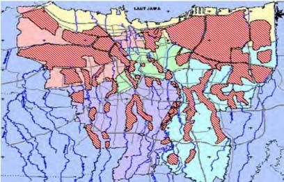
Any types of disasters
B Investment
Risk‐resilient critical infrastructure
B‐1 Risk‐Resilient Critical Infrastructure
Case example of Risk-Resilient Critical Infrastructure
The Blue Line subway that opened in 2004 was designed with help from Japan and includes many elements of
disaster risk reduction. Since Bangkok is located in a flood‐prone area, the subway entrance is located higher
than the sidewalk to prevent water intrusion. Also the entrance is equipped with a water shield. Some
ventilators are set at a higher position, and a drainage pump is installed.
Subway that is resistant to flood (Photo:Shinichi Kubo/JICA)
When the airports and roads were closed in the 2011 flood, The Blue Line was
able to continue to operate even in flooded areas without intrusion.
7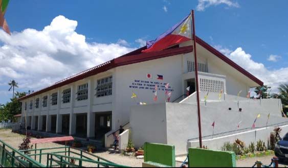
B Investment Earthquake/Tsunami
Develop systems for constant monitoring/information service
of earthquake and Tsunami
Terminal Ocean-bottom Optical
B-2 Earthquake Observation Equipment equipment seismometer/Tsuna submarine
mi meter cable
Seafloor Observation System for Earthquakes and
Tsunamis of Submarine Cable Type
The seafloor observation system for earthquakes and
tsunamis of submarine cable type makes it possible to
observe submarine earthquake activity and associated
tsunami activity. Excellent evacuation effect is
expected by combining it with an alarm system.
GPS Buoy System
GPS‐mounted buoys can measure offshore waves
and tidal levels, including tsunamis, in real‐time
by using satellite positioning information.
Real-time Analysis System of
GNSS CORS (REGARD System)
GNSS CORS
The positons of GNSS Continuous Operating
Reference Stations (CORS) are precisely calculated
and monitored. The system estimates ground
movements due to earthquakes, volcanic activities,
and plate motions, and contributes to hazard GNSS observation and Estimation of ground Estimation of magnitude
real-time analysis of data. movements caused by
mitigation. large earthquakes.
and earthquake fault
parameters
The REGARD system monitors positions of GNSS CORS and estimates ground movements and
earthquake magnitude in real-time. The results are expected to improve accuracy of Tsunami
simulations especially for earthquakes larger than magnitude 8.
8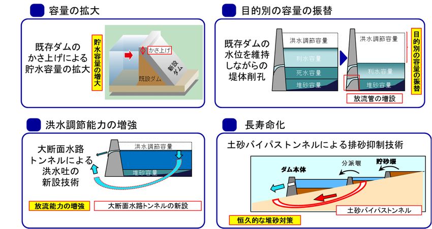
Earthquake/Tsunami
B Investment
Promote seismic reinforcement for houses/buildings and infrastructures
B-3 Seismic Reinforcement/Quake‐proof Technologies Jacket
Earthquake-Resistance Wharves
(e.g. Jacket Method)
Seismic Reinforcement / Quake-proof of Bridges Jacket pier is constructed by
As a result of damages on bridges in the Great Hanshin‐Awaji using the jacket type structure The image of Jacket
Earthquake, measures have been promoted in Japan. which is a space truss of steel Method
pipes fixed to the seabed by
steel pipe piles. It has high IHIのHPより
horizontal rigidity and high
Thilawa Port, Myanmar
earthquake‐resistance. (Photo:TOYO
Construction Co.,Ltd.)
Seismic Strengthening / Isolation-system of Houses/Buildings
Based on many experiences of disasters in
the past, Japan has promoted seismic
Reinforcement strengthening measures. Seismic isolator
of bridges
Reinforcement of columns
Condition of a bridge after the Great East Japan Earthquake Seismic isolator
(seismic reinforcement was completed) steel plate
Steel
plate
cover Carbon
Filling with fiber sheet
mortar
Rubber
There was no fall/collapse caused by earthquake vibration on Strip for fastening
steel plate
seismic reinforced bridges in the Great East Japan
Seismic isolator
Earthquake. Therefore, utilization of such technology is Reinforcement Reinforcement by
expected in overseas including know‐how of architectural by covering wrapping with
design. with steel continuous
plates carbon fiber sheet
Large vibrations
In the Great East Japan Earthquake, seismically isolated buildings
didn’t have damages to the structural frame caused by
earthquake motion, and proved the effectiveness to the major
earthquake.
9B Investment Meteorological disaster
Develop systems for constant monitoring/information service
of weather and river level
B-4 Meteorological and Hydrological Observation Instruments
Solid-state Weather Radar Radiosonde
Japanese radar manufacturers Advantages of Japanese
developed cutting‐edge solid‐state radiosondes are
• High observation accuracy,
weather radar. • Downsizing and lightening
Advantages of the solid‐state weather the instrument, and
radar are • Saving running cost.
• Saving running cost,
• Improving stability and
maintainability of the system, and
• Lessening the use of radio‐frequency
resource by narrower bandwidths.
Radiosonde
3L Water Level Gauge Lidar A radiosonde observes upper
Weather radar atmospheric conditions (e.g.,
‐ Low Cost (lower cost by 10% than conventional models) temperature, wind) up to altitudes
‐ Long Life (maintenance free for a long term, operable for 5 years or more without power supply) of around 30 km lifted by a
‐ Localized (Local river authorities are able to measure and monitor water level on their own) balloon.
It is a lower price water gauge
specializing on observation of
Observation Browse by
flooding, which operation and data Cloud vendor smartphone, etc.
maintenance are simple.
Additionally, by unifying the
central/local information of rivers
with a cloud service, water level control
module -0.66 m from bank crown
information service can be browsed
by anyone from a smartphone, etc. Example of a 3L
You can see the height of surrounding ground by sliding.
water level gauge Water level information service using a cloud service
This water gauge was developed as a crisis management type water gauge for small‐ and medium‐sized rivers and mainly installed at areas
with high risks of floods. It enables residents to be aware of risks and evacuate voluntarily, measures of software on residents' viewpoint
was promoted. 10B Investment Meteorological disaster
Promote improvement of infrastructures to protect lives/properties
from flood due to typhoon/heavy rain or landslide disasters, etc.
B-5 Water and Disaster Management (Dam Upgrading under Operation, River Development, etc.)
"Dam upgrading" to Effectively Use Existing Dams Enlarging Capacity Exchanging Capacities between Purposes
As a dam body is expected to be healthy almost
capacities by purpose
New outlet is Flood control
Change allocated
Flood control capacity
permanently if it is appropriately constructed and
storage capacity
Capacity of installed while capacity
Increase water
Raising a
reservoir is dam body
maintaining Water utilization
operated/maintained, for existing dams, it is important to enlarged by water level of capacity
Water utilization
utilize effectively and sustainably for a long term. raising existing the existing Dead water capacity capacity
Existing
dam body dam dam Sediment Sediment
capacity capacity
There are many actual achievements about dam upgrading Additional construction of
water discharge pipe
which improves functions of existing dams while operating
them, environmental and social impacts can be kept to a Enhancing Flood Control Capacity Prolonging Dam Life
minimum. Sedimentation is controlled by installing
New tunnel Flood control capacity
sediment bypass tunnels
Understanding issues in watershed areas through dam spillway is Sediment storage weir
installed Splitting weir
inspections and sharing such issues with relevant Sediment capacity
Dam body
countries, propose the dam upgrading business in
combination with a dam inspection system (guidance, Increase discharge New large cross section water channel
capacity tunnel Sediment bypass tunnel
criteria, measuring instrument, etc.), as a solution. Permanent sedimentation
measures
Successful Example of Water Control Business
Floodway that protected the Manila old urban area 2009 Massive flood in Manila
against a massive flood at Manila in 2009
For the Philippine Pasig‐Marikina River, the Main affected area
Manggahan floodway was constructed with Planned 2,900 m3/s
Old urban area
supports from Japan based on disasters in the protected against
heavy damage
past. Because of typhoon Ondoy hitting Metro
Planned 2,400 m3/s
Manila on September 2009, over 500 people
became victims around the upstream area in Floodway that
protected the
downstream area
Metro Manila. However, around the downstream Planned at river mouth 1,200 m3/s, just below flow
splitting 500 m3/s
area, thanks to the Manggahan floodway, the
flow rate was cut up to 3,000 m3/s out of the
planned flow rate of 2,400 m3/s and the flow rate Manggahan floodway, Japan Planned 0 m3/s, but 35 m3/s discharged by the inner water
drain pump to the main river
in the downstream area was successfully supported for its construction
controlled to about 600 m3/s that was almost
same as the planned flow rate.
If the floodway was not prepared, it was assumed that the old urban
area, a downtown of Manila, was severely damaged 11B Investment Meteorological disaster
Promote improvement of infrastructures to protect lives/properties
from flood due to typhoon/heavy rain or landslide disasters, etc.
B‐6 Forest Conservation Works
(Constructions and forest management for disaster risk reduction)
Forest Conservation Works: techniques for disaster risk reduction through forest management
(Forest conservation works had been developed
as techniques to maintain and improve the
function for disaster risk reduction by forest.)
Restoration and prevention of damaged ⼭腹⼯による復旧
mountains by forest conservation works. Occurrence of a disaster Completion of Situation 22 years
restoration works after the restoration works
Damage control of driftwoods occurred by
hillside collapse by a driftwood catching check
dam.
Protection of hinterland from blown sand and
wind, and attenuation of tsunami energy by a
coastal forest for disaster risk reduction.
Driftwood Catching Check Coastal Forest for disaster
Dam prevention
12Any types of disasters
C Risk education
Raise awareness for disaster risk reduction and promote risk education
C‐1 Risk Education Materials, Citizens
Empowerment, Training and Exercise
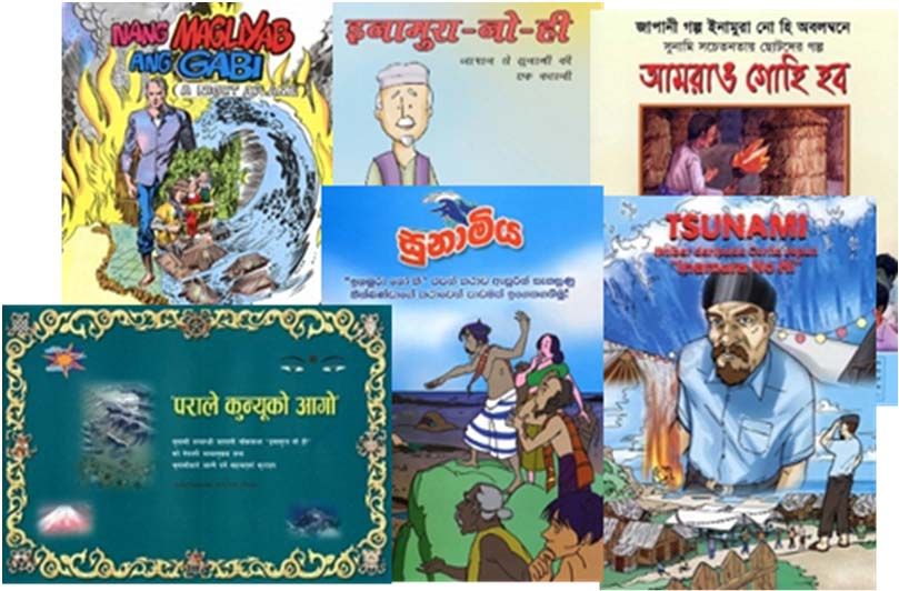
Risk Education Materials
Risk education materials in many languages; The Tale of
“Inamura‐no‐hi” tells the importance of evacuation from
tsunami, based on the experience of tsunami evacuation
after the Ansei Nankai Earthquake in Hirokawa Village,
Wakayama Prefecture.
C‐2 Human Resources Development
Training Programs ”Knowledge Co-creation Programs”
Japan invites trainees from developing countries to many
programs in such fields as DRR governance and mainstreaming,
earthquake, tsunami, flood, hydromet and so on. These programs
are conducted with knowledge and experiences on DRR in Japan.
Management of “International Training on Seismology and
Earthquake Engineering (since 1960)” and “Disaster Management
Policy Program: Water‐Related Disaster Risk Management Course
(since 2008)” in collaboration with the Japan International
Cooperation Agency (JICA) and the National Graduate Institute
for Policy Studies (GRIPS) (ICHARM)
Management of “Visiting Researcher Program” (since 1960, ADRC)
Management of “Comprehensive Disaster Risk Reduction (A)” (since 2019, ADRC/JICA)
Management of “Promotion of Mainstreaming Disaster Risk Reduction“ (since 2018, ADRC/JICA) 13D Emergency warning, Evacuation support Any types of disasters
(Earthquake, tsunami, volcano)
Sharing disaster information, communicate to relevant organizations
and citizens, early warning
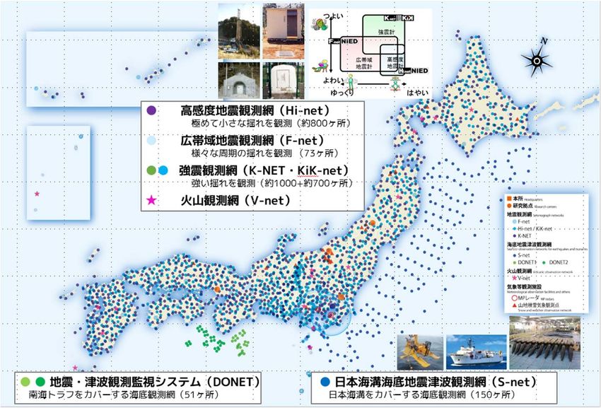
D‐1 Monitoring of Waves on Land and Seafloor (MOWLAS)
MOWLAS is a monitoring network that covers the lands and seafloors all over Japan, and can
immediately and accurately observe hazard phenomenon of earthquakes, tsunamis and
volcanic eruptions in Japan. The observed data is utilized not only for research on natural
disaster mechanisms but also for disaster reduction as it is directly provided to central
government, local governments and private companies.
Hi‐net (high sensitivity)
for micro tremors (~800 spots)
F‐net (full range)
for broadband‐frequency tremors
K‐net, KiK‐net
(73)
for strong motions (~1000,
~700) (for volcanos)
V‐net
DONET seafloor network for S‐net seafloor network for earthquakes
earthquakes and tsunamis through and tsunamis in Japan Trench (150 )
Nankai Trough (51) 14D Emergency warning, Evacuation support Meteorological disaster
Any types of disasters
Sharing disaster information, communicate to relevant organizations
and citizens, early warning
D‐2 Satellite Observation Data for D-3 Early Warning System (L‐Alert)
Emergency Responses
Response to Natural Disasters - Earthquake, Eruption, Tsunami A disaster information sharing system that utilizes the know‐
how of the L‐ Alert, a system that collects, analyzes, and
Emergency observation was performed by “ALOS‐2” to detect distributes disaster information consistently and delivers
damages caused by the eruption of Krakatau and Tsunami in disaster information quickly and reliably to residents.
Indonesia, 2018.
(Left) Before the eruption, (Model in Peru)
(Right) after the eruption. Collecting information Information analysis Information distribution
The collapse of south-
west part of the island is IGP Mobile
(Geophysical Institute
shown in the red circle of Peru) phones
Broadcasting
(approx. 2km) in the right Earthquake
information
Ministry of
Transport and
National
Aggregation
image. Institute of
Communications
SENAMHI
Analysis by GSI from ALOS‐2 raw data of JAXA (National Service of disaster information
Meteorology and Civil Defense sharing system
Hydrology of Peru)
The satellite data contributed to helping the Indonesian Tsunami SNS
information
authorities to estimate damages and losses from the disasters.
Flood forecasting system was developed for Chao Phraya river basin
D‐4 Flood Forecasting Software in Thailand where the great flood in 2011 caused huge damage.
Project for Comprehensive Flood Management Plan for the Development of a flood forecasting and early warning system for the
Chao Phraya River Basin in Thailand Indus River basin of Pakistan as part of the UNESCO Pakistan project
(Technical Cooperation for Development Planning) (ICHARM)
World's first Development of a flood forecasting system for the Philippines and Sri
technology Lanka(ICHARM)
that brought
the full-scale Development of systems for agriculture drought monitoring and
system to drought seasonal forecasting for Ceará, a northeastern state of Brazil,
forecast by using the Coupled Land and Vegetation Data Assimilation System
inundation
(CLVDAS) backed by the second Advance Microwave Scanning
Inundation forecasting map Water level forecasting map area
Radiometer (AMSR2) on the Shizuku satellite (ICHARM) 15Earthquake/Tsunami
D Emergency warning, Evacuation support Any types of disasters
Sharing disaster information, communicate to relevant organizations
and citizens, early warning
D‐5
Urgent Earthquake Detection D-6 Emergency Warning Broadcast System
and Alarm System
Infrastructure Development for Providing Disaster-related Information
Seismometers immediately determine the expected secondary
wave and the damage of the earthquake and send out warnings to Utilizing terrestrial digital television broadcasting network as
shut off the electricity supplied to the trains when they detect the the basis for informing the inhabitants of disaster‐related
primary wave. information as soon as possible.
Shut off electricity
seismometer warnings Emergency
Brakes
Applied
Emergency
P‐wave warning
Possible to receive
× 17
Epicenter
S‐wave emergency information
indoors and outdoors.
No train derailed and no passenger got injured due to
2011 Great East Japan Earthquake.
D-7 Disaster Information Management
System (DIMS)
Collecting real‐time data from disaster areas,
and managing collected data centrally, then
supporting the decision making by
administration to issue the alert
automatically.
16Any types of disasters
E Emergency rescue activities
Rescue/first‐aid/emergency medical care for life saving, measures for
evacuation sites, providing relief supplies
E-1 ICT Disaster Management Unit
Car type
Miniaturized into a
container type, a car
type, or an attaché
Incorporating communications equipment, case type and applied
to various forms and
including a power supply, battery, and radio carried with ease.
equipment, to build a communications Container type Attaché case type
network with ease. Trunk
Used as a communication infrastructure that communications
network
provides a minimum ICT environment in
times of disaster and quickly restores
communications.
Transportable ATC (Air Remote‐operated
E‐2 E-3 Drain Pump Car E-4 Equipment, Unmanned
Traffic Control) Tower Construction
Used as alternative measures in case of During emergency recovery works, utilize
It worked well for water drainage at
damages of ATC tower caused by the Great East Japan Earthquake. remote‐operated construction machineries
unexpected circumstances to prevent secondary damages.
Appearance Inside of the operation room Drain pump car
17Any types of disasters
F Smooth recovery and reconstruction
Assistance for formulation of rehabilitation and recovery plan,
support for livelihood
F‐1 Assistance for Formulation of
Rehabilitation and Recovery Master Plan
The Project on Rehabilitation and Recovery from Disaster
Utilize ODA to support the formulation of a basic reconstruction plan with Build
Back Better Concept including countermeasure to flood tide and land use plan.
Formulation of Community Recovery Plan
F‐2 Disaster Waste Management
Various kinds of waste which are generated in massive volume all at once
delay recovery/ reconstruction. In terms of maintaining living environment,
public hygiene and material cycles, swift removal of waste is required.
Know‐hows and technologies based on Japan’s experiences of disaster
Disaster waste caused by flood Intermediate treatment facility of
waste management are able to utilize to solve these tasks. mixture (sorting and crushing)
F‐3 『JOEN』 ~Salt removal work from farmland~
Restoration of Farmland from Sea Water Flood
Damage by Tsunami
In the Great East Japan Earthquake in 2011, many farmlands
were flooded with sea water by tsunami. In order to remove
salt content remaining in the soil, the salt removal “Joen”
manual was created and salt removal works were carried
Farmlands flooded by tsunami. ・Forming mole drains ・Filling & stirring
out. These knowledge and methods can be utilized in the (The Great East Japan Earthquake, Mar. 2011) ・Scattering lime-based with fresh water
case of tsunami damage in foreign countries as well. soil conditioner 18Any types of disasters
F Smooth recovery and reconstruction
Assistance for formulation of rehabilitation and recovery plan,
support for livelihood
F‐4 Reconstruction of Infrastructure
The school is
‐Based on Build Back Better(BBB)Concept designed to be
used for
evacuation
To implement Build Back Better concept, Japan’s ODA
center in
assist rebuilding resilient infrastructure; school, emergency
hospital and dike. (Phillippines)
Reconstructed elementary school by ODA Grant assistance
F‐5 Support for House Reconstruction
In the disaster area of the Great
‐Based on Build Back Better(BBB) Concept Nepal earthquake of 2015, subsidies
In reconstruction of earthquake damaged houses, Japanese based on ODA loans were provided
for house reconstruction that fulfill
ODA can support formulation of standards and guidelines,
the earthquake resistance
through the technical cooperation for enhancement of requirements which promoted
earthquake resistance. reconstruction.
F‐6 Support for Livelihood Recovery
Considering Victims In the case of the Yolanda
Typhoon of 2013, food
‐Based on Build Back Better(BBB)Concept processing facilities were
In the reconstruction from the Great East Japan Earthquake of reconstructed for the fishery
industry, which is the major
2011, various reconstruction projects were implemented with industry in the affected area.
victim’s consent. These experiences can be utilized in the
recovery from disasters in other countries.
19You can also read