Development of Real-Time Flood Forecasting and Warning - Deltares
←
→
Page content transcription
If your browser does not render page correctly, please read the page content below
Development of Real-Time Flood Forecasting and Warning
System for the Sava River Basin

           Klaas-Jan van Heeringen1, Hanneke Schuurmans2, Mihailo Anđelić3, Victor Simončić4, Imra
                                    Hodzic5, Sabina Hadziahmetovic5

       ABSTRACT: Disastrous floods in May 2014 in Sava River basin resulted in 79 casualties and substantial
economic damage in Croatia, Bosnia, Herzegovina, and Serbia. Assessments of the total damage in the area
range up to 3.8 billion Euros. Distressing is the fact that besides flooding the Balkan region recently suffered
from severe droughts as well. In order to be more resilient to flood and drought events, data and model output
sharing is key. Better information will lead to better decisions. The Flood Forecasting and Warning System
(Sava-FFWS) in which five countries jointly work together is at the forefront of transboundary cooperation. The
FFWS, which is based on the well-known Delft-FEWS software, lends ample data and information enabling
ultimately the decision makers to make right management decisions and implement operational measures to
prevent and mitigate severe flood and drought situations on the basis of reliable forecasts of flows and discharges
with a long lead time. The paper outlines key components of the Sava-FFWS illustrated with concrete
application examples.

        Key words: real-time flood forecasting, Delft-FEWS, Sava river basin, Sava HIS, hydrological models,
hydraulic models, numerical weather prediction, water levels, discharges, precipitation, temperature, snow, GIS
data, dissemination

    Razvoj sistema za prognozu i upozorenje na velike vode u
realnom vremenu za sliv reke Save

       APSTRAKT: Katastrofalne majske poplave iz 2014. godine u slivu reke Save pogodile su delove Bosne i
Hercegovine, Hrvatske i Srbije i ostavile iza sebe pustoš: 79 osoba je izgubilo život a ogromna materijalna šteta
je procenjena na preko 3.8 milijardi evra. Velika nevolja je i to što u poslednje vreme značajne delove Balkana
često pogađaju i žestoke suše. Da bi se u regionu povećala otpornost na poplave i suše, od ključnog značaja je da
se međusobno razmenjuju podaci osmatranja i rezultati modela za prognozu i najavu ovih fenomena – jer bolje
informacije sledstveno rezultiraju u boljim odlukama i rešenjima. Sistem za prognozu i upozorenja na velike
vodea u slivu reke Save (Sava-FFWS) u okviru kojeg 5 savskih zemalja rade zajedno predstavlja odličan primer
dobre i višestruko korisne prekogranične saradnje u međunarodnom slivu. Za razvoj Sava-FFWS korišćen je
dobro poznati Delft-FEWS softverski paket a razvijeni sistem omogućuje svestrane analize procesa oticanja i
hidrološke prognoze u slivu reke Save, sa dovoljno dugim prognoznim periodom; kao takav, on daje savskim
državama važan alat za donošenje pravilnih odluka i preduzimanje blagovremenih mera usmerenih na
predupređenje ili ublažavanje posledica od poplava i suša u slivu reke Save. U radu su prezentirane glavne
karakteristike Sava-FFWS i konkretni primeri primene.

       Ključne reči: prognoza velikih voda u realnom vermenu, Delft-FEWS, sliv Save, Sava HIS, hidrološki
modeli, hidraulički modeli, numerička prognoza vremena, vodostaj, proticaj, padavine, temperature, sneg, GIS
podaci, disseminacija prognoza

       1
         Deltares, klaasjan.vanheeringen@deltares.nl
       2
         Royal HaskoningDHV, hanneke.schuurmans@rhdhv.com
       3
         Mihailo Anđelić, mandjelic007@yahoo.co.uk
       4
         Eptisa, imra.hodzic@gmail.com, viktor.simoncic@gmail.com
       5
         HEIS, sabina.hadziahmetovic@heis.ba

                                                            1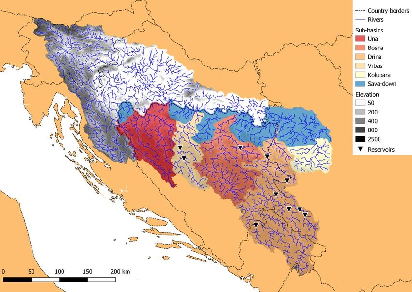
1 Introduction
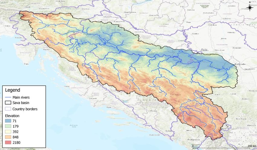
The Sava River basin covers an area of approximately 97,700 km2 including large parts of Bosnia
and Herzegovina, Croatia, Montenegro, Serbia and Slovenia (see
Figure 1 below). It is the largest tributary by discharge to the Danube River, with an average
discharge of about 1700 m3/s, which accounts for almost 30% of the Danube’s total discharge at their
confluence in Belgrade. The length of the Sava River, from its source in the western Slovenian
mountains to the confluence with the Danube River, is well over 900 km [ISRBC 2017].
Figure 1. Sava River basin (data displayed on map is from the Sava GIS portal)
Slika 1. Sliv reke Save (podaci prikazani na mapi preuzeti sa Sava GIS portala)
Disastrous floods in May 2014 in Sava River basin resulted in 79 casualties and substantial
economic damage in Croatia, Bosnia, Herzegovina, and Serbia [ICPDR 2015]. Assessments of the
total damage in the area range up to 3.8 billion Euros. Distressing is the fact that besides flooding the
Balkan region recently suffered from severe droughts as well. In order to be more resilient to flood and
drought events, data and model output sharing is key. Better information will lead to better decisions.
The Flood Forecasting and Warning System (Sava-FFWS) in which five countries jointly work
together is at the forefront of transboundary cooperation. This system performs a number of
sophisticated tasks and provides ample information to users that enables them to make right
management decisions and implement operational measures to prevent and mitigate severe flood and
drought situations on the basis of reliable forecasts of flows and discharges with a long lead time of
forecast.
Starting from June 2016 onward, Deltares, along with Royal HaskoningDHV, Eptisa, the
Hydro-Engineering Institute of Sarajevo and Mihailo Anđelić has been implementing the World Bank-
funded regional project entitled “Joint Flood Forecasting and Management in the Sava River Basin”.
The project’s main objective is to develop and establish an integrated real-time flood forecasting and
warning system for the entire Sava River Basin (the so called Sava FFWS), which is jointly operated
and maintained by the 5 Sava riparian countries (Bosnia and Herzegovina, Croatia, Montenegro,
2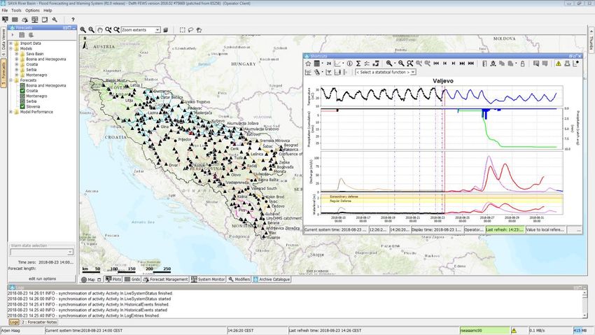
Serbia and Slovenia) in close cooperation, coordination and support of the Secretariat of the
International Sava River Basin Commission (ISRBC).
Operational forecasting is not only dependent on the availability of a proper forecasting system,
but also on skilled, well-trained staff and good coordination between its users. Because of the complex
hydrographic network of the Sava basin, many hydrological links exist between the riparian countries,
while some of these links are multiple in nature. This is also reflected in the large number of
beneficiary institutions (19 in total) involved in the project. This means that there is a strong need for
international cooperation and requires to set-up a mature organization with well-defined and mutually
agreed upon set of working procedures.
2 Stakeholders
The five riparian countries of the Sava River basin are Bosnia and Herzegovina, Croatia,
Montenegro, Serbia and Slovenia. These countries with the exception of Montenegro, are members of
the International Sava River Basin Commission (ISRBC) that has been established to implement the
Framework Agreement on the Sava River Basin (FASRB). The ISRBC Secretariat is the
administrative and executive body of the ISRBC. In addition to the ISRBC, Table 1 provides an
overview of the national organizations that are (direct) stakeholders in the Sava FFWS project.
For efficient stakeholder interaction, project management and decision making the following
organizational structure has been established within the project:
Steering board.
International Working Group.
Country Working Groups.
The Steering Board, the International Working Group and the Country Working Groups were
established for the general purpose of management, monitoring and coordination of the Sava FFWS
project implementation.
The purpose of the Steering Board has been to monitor and make decisions about the FFWS
project and its progress. The Steering Board members have been responsible for final decisions and
resolving issues arising. They also comment on and approve conclusions of the International Working
Group, and share their opinion about the deliverables with the World Bank.
The purpose of the International Working Group has been to harmonize and verify the input of
the Country Working Groups, discuss international elements of the Sava FFWS and test the milestone
products before the products were considered sufficiently mature to be presented at the Steering Board
meetings.
The general purpose of the Country Working Groups has been to secure the input of the local
interests, knowledge and workflows of each country.
Nominated representatives from all five riparian countries have actively participated in the work
of the above three project management bodies. As far as it has been practical and possible, the
countries’ specialists who were already active in the existing ISRBC technical bodies have also been
nominated to serve in these project bodies.
Table 1. Stakeholders in the Sava-FFWS Project
Tabela 1. Učesnici u realizaciji Sava-FFWS projecta
Country Organization Role
Bosnia and Federal Ministry of Agriculture, Water Policy making
Herzegovina Management and Forestry
Ministry of Agriculture, Forestry and Water Policy making
Management of Republic of Srpska
Federal Hydrometeorological Institute Operational forecasting for BiH
Republic Hydrometeorological Institute Operational forecasting for BiH
3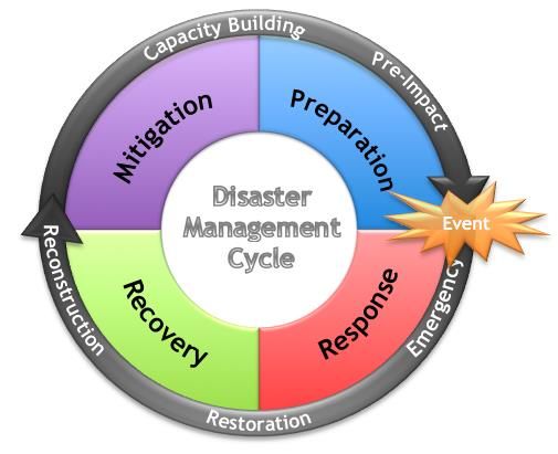
Country Organization Role
Public Institution JU “Vode Srpske” Operational forecasting for BiH
Sava River Watershed Agency Operational forecasting for BiH
Brčko District Government:
Department of Public Safety District, Direct use of forecasts
Department for agriculture, forestry and
water management.
Croatia Ministry of Environment and Energy Policy making
Meteorological and Hydrological Service Operational forecasting for Croatia
Croatian Waters Public water management institution,
legal entity for water management, in
cooperation with DHMZ developing and
making the forecasts
Montenegro Ministry of Agriculture and Rural Development, Policy making and water management,
Water Management Directorate makes use of forecasts
Institute of Hydrometeorology and Seismology of Operational forecasting for Montenegro
Montenegro
Serbia Ministry of Agriculture, Forestry and Water Policy making
Management, Water Directorate
Republic Hydrometeorological Service of Serbia Operational forecasting for Serbia
Public Water Management Company Public water management organization,
“Srbijavode” makes use of forecasts
Public Water Management Company “Vode Public water management organization,
Vojvodine” makes use of forecasts
Slovenia Ministry of the Environment and Spatial Planning Policy making
Slovenian Environment Agency Operational forecasting for Slovenia
Slovenian Water Agency Public water management organization,
makes use of forecasts
- International Sava River Basin Commission Coordination
3 Flood Risk Management and Operational Forecasting
Disaster Risk Management (DRM) as well as Flood Risk Management (FRM) itself can be
presented in the cycle (shown in Figure 2) and it consists of 4 phases: response, recovery, mitigation
and preparation. The response phase starts right after a disaster/flooding and includes all emergency
activities related to rescue, first aid as well as evacuation. Through restoration and reconstruction the
second phase of recovery starts, where all activities should be implemented based on disaster/flood
risk reduction. The third phase is a phase of mitigation. This phase consists of structural and non-
structural measures and activities, which should mitigate impacts of all future natural hazards/floods,
like dikes construction. The last phase is related to the preparedness for upcoming flooding events.
This phase covers operational flood forecasting and setting up of early warning systems. By building
the Sava FFWS and capacity development, Sava River basin countries are implementing one of the
non-structural measures in order to become more resilient to future possible upcoming events.
4Figure 2. The Disaster Risk Management cycle
Slika 2. Ciklus upravljanja rizikom od katastrofa
One of the most important factors regarding real-time flood forecasting and warning systems is
lead time of forecasts and warnings. WMO (2011) issued a separate manual on flood forecasting and
warning. As stated in this publication, there are no hard and fast rules regarding the provision of lead
time for warnings. The requirement depends on specific operational needs and rests on a number of
considerations, principally:
(a) The size of the catchment and nature of flooding: large catchments with extensive flood
plains have slow response time, while, conversely, headwater catchments in steep hilly areas
afford little potential to provide advance warning of flooding;
(b) The nature of the risk and impacts, and whether or not evacuation or physical protection (for
example sandbagging, embankment strengthening) needs to be provided;
(c) Whether or not staged alerts and warnings are used.
Lead times are dependent not only on the appropriate action related to the flood warning, but also to the type
and accuracy of information available.
Figure 3 shows schematically the source of information needed for flood forecasting, projected
on the lead time scale bar.
Threat Response Action Flooding
Event starts
recognised begins occurs
Analysis Action
Monitoring Notification Decision making Warning
(Forecasting) (Mitigation)
Maximum (potential) lead time
Lead time
Mitigation time
Forecasting Warning Response
Figure 3. Lead times available for forecasting, warning and mitigation response
Slika 3. Vreme raspoloživo ze prognozu, upozorenje i preduzimanje potrebnih mera
5The target lead time, is a combination between the time to peak and overhead time which consists of time
needed for the forecaster and the warner (
Figure 4). Target lead times are often agreed in consultation with civil protection authorities, or
defined nationally as part of a service level agreement. In general, the complexity of forecasting and
early warning systems is reflected in the interdependency between forecast accuracy and timeliness
(lead time).
The development of the accuracy curve in relation to lead time depends on two main aspects:
1. Accuracy of meteorological forecast;
2. Accuracy of hydrological/hydraulic model and thus flood forecast.
The inclusion of hydrological/hydraulic models, feeded by quantitative precipitatoin forecast, is
essential as rainfall forecast is not the same as forecasting of floods. Based on the outcomes of the
hydraulic/hydrological models and the setup of thresholds for warnings per location one is able to
operationally monitor and disseminate the flood warnings.
6Figure 4. Theoretical illustration of target lead time (TLT) compared to time to peak (Tp), including relevant
flood warning thresholds (Environment Agency, 2017)
Slika 4. Ilustracija ciljnog prognoznog vremena (TLT) u poređenju sa vremenom do špica hidrograma(Tp),
uključujući i dva relevantna praga za izdavanje upozorenja o nailasku velikih voda (Environment Agency, 2017)
4 System setup
4.1 Delft-FEWS software
In developing the Sava FFWS, the Consortium has used the well-known Delft-FEWS as the
core software package [Werner, 2013]. Delft-FEWS is made by Deltares, the Netherlands, and
consists of a sophisticated set of configurable modules for building a hydrological forecasting system
that can easily be customized to suit specific users’ needs and requirements; it is freely available
expert software that handles efficiently large amounts of data, integrates various hydrological and/or
hydraulic models with the real time observations and the most recent meteorological forecasts, and
enables consistent data quality control, standardized work processes, visualization and reporting. In
addition, the Delft-FEWS can orchestrate massive computations - on dedicated hardware and/or in
cloud - and allows for remote collaboration between multiple experts and parties working and
interacting with the same data. This means the countries independently can use the models in
operational mode, forced with the different meteorological input used by the riparian countries.
As of February 2018, the Sava FFWS is in an advanced stage of development with one primary
and three backup systems and is scheduled to be completed by the end of October 2018, by which time
it will start to be routinely used and maintained in the whole region.
7Figure 5. Sava FFWS user interface, showing GIS map with warning status per forecasting location detailed
hydrographs, meteorological and hydrological parameters like precipitation, temperature as well as observed and
forecasted discharges and water levels (profile Valjevo in this example)
Slika 5. Korisnički interfejs Sava FFWS sa GIS mapom, pragovima za upozorenje na velike vode i grafičkim
prikazom osmotrenih i prognoziranih hidroloskih i meteoroloških parametara uključujući osmotrene i
prognozirane vodostaje i proticaje (profil Valjevo u ovom primeru)
4.2 Sava FFWS as client-server application and its hosting
The post project organization of the Sava FFWS, concerned in particular with its support and
maintenance, depends to a degree on the system architecture and the agreed arrangements for hosting
the Sava FFWS. To this effect, the Sava FFWS consists of four hosting locations, i.e. one Primary and
three Backup locations. Under normal conditions, the Backup systems will retrieve data from the
Primary system through an automatic data synchronization process. The Primary system is the only
system that is used to carry out operational tasks under normal circumstances, such as the running of
forecasts or the uploading of changes to the configuration. A separate set of servers is configured to
host the additional functionality, such as the archive and web dissemination.
The responsibilities with respect to hosting of these systems have been distributed as follows:
• ARSO Slovenia: Primary System and Sava HIS-RT
• AVP Sava Bosnia and Herzegovina: 1st Backup System
• DHMZ Croatia: 2nd Backup System
• RHMZ Serbia: 3rd Backup System
• ISRBC Secretariat: Archive, Web Portal and Sava HIS
For the purpose of the future development and for the testing of new features of the Sava FFWS
before their inclusion into the operational system, a 100% independent operational testing system of
the Sava FFWS is available, next to a Stand-Alone (SA) application. This SA runs on any suitably
configured desktop computer, and has no interaction with any other application or the live system.
8The Delft-FEWS software comprises the several components as illustrated in Figure 6. Note that
this figure just shows the components of one single system. These components can be separated in two
groups: components on the server and components on the client.
Figure 6. Components in a Delft-FEWS client-server application
Slika 6. Delft-FEWS komponente u klijent-server aplikaciji
On the server side the main component is the Master Controller (MC). This is in fact the agent
that monitors status of all components and distributes tasks to the so-called Forecasting Shell Servers
(FSS). Actual tasks, like importing data or running of models are performed on the FSS. The system
uses a central database which can be Oracle, MS SQL Server or PostgreSQL.
On the client (a laptop or PC where the users use the system), the so-called Operator Client
(OC) is run. This is a thick-client, Java based application, that connects to the Master Controller
through https over the internet. Data is read and cached in a local data repository (referred to as the
LocalDataStore).
4.3 Operational data and numerical weather predictions
The Sava FFWS connects to the real-time operational telemetry data which is automatically
collected in the already existing Sava HIS application. Sava HIS is hosted by the ISRBC and provides
a web service based on the WaterML2 protocol. The telemetry data consist of water levels and
discharges at 345 fluvial gauges and precipitation, air temperature and snow depths at 257
meteorological gauges. Automatic validations on doubtful or unreliable measurements are done, based
on exceeding of hard or soft validation limits, same readings or too high rates of changes. Thresholds
based on operational warning levels have been implemented to visualize warnings.
The weather forecast is derived from various Numerical Weather Prediction (NWP) products
that provide up to 5-day and 10-day forecasts of precipitation, temperatures, snow information, soil
moisture etc. The NWPs include Aladin, NMMB, WRF and ECMWF deterministic models, next to
the ECMWF ensemble forecasts for the whole basin. The NWP products and their characteristics have
been listed in Table 2.
Table 2. NWP products in the Sava FFWS
Tabela 2. Produkti modela za numericku prognozu vremena (NPV) u Sava FFWS
Model/ Spatial Temporal Forecasting Updated
9Source Resolution Resolution period every…
ECMWF 8 *10 km 1h 10 days 12 h
ECMWF EPS 16 *20 km 1h 10 days 12 h
Aladin 4.5 km 1h 3 days 6h
Aladin HR 4 km 1h 3 days 6h
NMMB 3 * 4 km 3h 3 days 12 h
WRF SRB 4 * 6 km 3h 3 days 12 h
WRF BiH 2.5 km 1h 4 days 24 h
WRF MNE 1 km 1h 5 days 12 h
WRF MNE 3 km 3h 5 days 24 h
The relevant meteorological information is transformed to catchment average data that is used
as input to the hydrological models. Various aggregations have been realized to assist the duty
forecasters in easily interpreting the current situation and the expected situation to come. To this
respect, also precipitation radar and satellite images have been implemented, although this data is not
used for model input.
4.4 Hydrological and hydraulic simulation models
Within the Sava FFWS a large number of hydrological, hydraulic and Numerical Weather
Prediction (NWP) models have been implemented. Most of them are based upon pre-existing models
available in the beneficiary countries. Where applicable, these have been adapted and made
compatible with the Delft-FEWS operational forecasting system. The detailed hydraulic models are
coupled with the most suitable hydrological model, and the results of both are stored within the
system. Within the Sava FFWS, distinction can be made between default runs, which are scheduled to
run automatically at certain predefined time intervals, and the manual user runs, which can only be
run manually.
Table 3. Forecast workflows with NWP and model combinations within Sava FFWS
Tabela 3. Prognozne radne procedure - kombinacije NPV i hidroloških/hidrauličkih modela u Sava FFWS
4.5 Hydrological distributed wflow model
Deltares and Royal HaskoningDHV built a catchment-wide hydrological model for the main
beneficiaries: Bosnia and Herzegovina, Serbia and Montenegro, the so-called Wflow Sava model.
WFlow is a framework that can contain different hydrological models. The WFlow Sava model is
based on the HBV model. WFlow is based on multiple grid layers, which result together in a
hydrological model. The spatial resolution of WFlow is 250 meters. The meteorological input is grid
based. The advantage of this grid based principle is that all available precipitation and temperature
10stations can be used for the creation of the grid. Also, the model generates output at every location
within the river basin, which can be obtained easily from the Delft-FEWS spatial display.
Figure 7. Six Sava sub-catchments modelled in WFlow coupled with OpenDA and RTC-Tools
Slika 7. Šest savskih podslivova koji su obuhvaćeni Wflow modelom u sprezi sa OpenDA i RTC alatima
The WFlow model is coupled with the data assimilation package openDA, as well as with the
RTC-Tools package for reservoirs. To simplify the setup for openDA, and to accommodate forcing the
model with the Croatian flow boundaries, the WFlow model is split up in 6 subcatchments (
Figure 7). The Vrbas (Bocac Dam, Jajce I), Bosna (Modrac) and Drina (Piva, Visegrad, Bajina
Basta, Kokin Brod, Potpec, uvac, and Zvornik) models are coupled online with a reservoir model build
in RTC-tools. The SavaDown model is forced with external boundary flows from Croatia (Sava, Bosut
and Spacva river) as well as the flows from WFlow Kolubara and WFlow Drina. There are 4
geographically disconnected parts of the Sava watershed that are included in the model as well. These
basins drain directly to the Sava River, and are included to calculate local flows for forecasting
location within the basins.
A completely separate and independent model has been setup for Montenegro, since the
hydrometeorological service in this country did not have any other hydrological simulation model.
This model has been setup at a later stage in the project, which enabled using new datasets [Imhoff,
2018].
In general the performance of the models it not very high. The sometimes very karstic
hydrology in the region makes it difficult to building models without deep analysis in the water
balances of the catchments [Bouaziz, 2018].
4.6 Data assimilation
11Deltares has co-developed an open source data assimilation platform, OpenDA [Weerts 2006,
Rakovec 2015], which includes a variety of data assimilation algorithms and that can be linked Delft-
FEWS. For the Sava project, the Asynchronous Ensemble Kalman Filter (AEnKF) algorithm is used to
update the initial conditions for the WFlow hydrologic model to meet the observed discharges over the
last couple of days as good as possible. As such, the performance of the forecasts is improved. Once
other relevant data becomes operationally available, like satellite soil moisture maps, these can be
included in the platform as well.
4.7 Predictive uncertainties
For the HEC-HMS Sava model with the ECMWF Ensemble plots, a statistical post-processing
approach [Verkade, 2015] is used to dress a confidence band around the ARMA corrected streamflow
ensemble traces. This band is a result of adding an estimate of hydrological uncertainty (using
Quantile Regression algorithms) to each individual streamflow ensemble member, where the estimate
is based on an historical hindcast (2010-2015) analysis in which daily streamflow forecasts are
generated using perfect meteorological boundary conditions. In this way an estimate of the ‘total
predictive uncertainties is produced that captures both the meteorological and hydrological
uncertainties.
Figure 8. Example of Ensemble Dressing of HEC-HMS Streamflow ensembles, showing confidence interval
bands (2rd subplot) and Q90-95-99 exceedance probability
Slika 8. Primer HEC-HMS ansambla protoka, pokazujući intervale poverenja (2. grafikon) za 90%, 95% i 99%
verovatnoce prevazilaženja prognoziranih proticaja
4.8 Performance indicators
Sava FFWS calculates daily the NWP and hydraulic/hydrological model performance for
preconfigured lead times by comparing stored predictions with later obtained observed data.
Performance is expressed with two indicators; the absolute bias and the root-mean-squared-error
(RMSE). The RMSE gives a good indication of overall performance, while the bias also shows
12whether the error is a result of over- or underestimation. For each lead time, the performance is
assessed over all forecasts available for a configured period of time.
The results of the performance assessment can be used in a later stage to decide on the
operational use and further developments needed for the NWP and simulations models.
5 Using the system & Transboundary cooperation
In close cooperation with the beneficiaries, an organizational structure has been established,
where the real-time operations, support and maintenance and development activities have been
identified. All these three components need both national and international cooperation.
One of the large benefits of the FFWS is that all forecasters in the Sava basin have the same
information and full insight in what happens in the other countries, as such enabling transboundary
flow forecasting.
The Sava FFWS has proven to be a comprehensive system that includes all data and models
contributed by the individual countries. This makes it a unique system when it comes to transboundary
cooperation on flood forecasting.
6 Knowledge transfer and capacity building
During the entire phase of the project, regular workshops and trainings were organized at
various levels of expertise. These included training sessions on the use of the Sava FFWS, the
configuration of the Delft-FEWS software and the backend IT infrastructure required to keep
everything in the system running. Training courses on the use of the Sava FFWS also included topics
on the general principles of hydrological forecasting. The courses were hosted by the various national
forecasting institutions throughout the region.
During the operational testing phase, regular two-weekly webinars were held for all users of the
Sava FFWS. The main goal of these webinars was to give users the opportunity to directly ask specific
questions to the consultants and actively participate in discussions. The use of such a format had the
additional benefit that other users could either learn from the answers (which they would have missed
if an e-mail or phone call was used) or even help with answering questions posed (as the answer would
sometimes require knowledge from other forecasting agencies). Another important goal of the
webinars was to share insights between users and allow for the transfer of knowledge and know-how
in using the system as well as on forecasting procedures. In this regard, on multiple occasions users
were asked to give a presentation on their daily forecasting routine (or what this looked like under
specific circumstances, such as during flood). These often led to fruitful discussions about general
practices and how things are done at other forecasting institutions.
7 Conclusions
The principal objective of the Flood Forecasting and Warning System of the Sava River basin is
to provide more information and support the stakeholders in taking balanced decisions in emergency
situations of upcoming floods. The Sava FFWS enables the five riparian countries to take the right
management decisions and carry out measures to prevent and mitigate severe flood events, based on
accurate forecasts of flows and discharges with a sufficiently long lead time. This requires close
cooperation with relevant stakeholders, managing the data and models on country level which is
crucial for successful development of the system. The Sava FFWS is of key importance in this
cooperation.
The Sava FFWS provides the forecasters of the hydrometeorological services an expert tool,
enabling them to generate hydrological forecasts based on observed telemetry data from hydrological
13and meteorological gauges and Numerical Weather Predictions (NWP). The Sava FFWS uses
hydrological and hydraulic models to compute the catchment runoff and river flows and water levels
and these models can be updated and improved at any time within the existing Sava FFWS platform.
8 References
Papers:
Bouaziz, L., Weerts, A., Schellekens, J., Sprokkereef, E., Stam, J., Savenije, H., and
Hrachowitz, M.: Redressing the balance: quantifying net intercatchment groundwater flows, Hydrol.
Earth Syst. Sci. Discuss., https://doi.org/10.5194/hess-2018-370, in review, 2018.
ICPDR 2015, Floods in May 2014 in the Sava River Basin, Brief overview of key events and
lessons learned. ICPDR and ISRBC, 2015.
https://www.icpdr.org/main/sites/default/files/nodes/documents/sava_floods_report.pdf
Imhoff, R., W. van Verseveld, B. van Osnabrugge, A.H. Weerts, 2018. Distributed hydrologic
modelling of the Rhine river: towards high resolution calibration-free hydrological models with
seamless large-domain parameter estimates. Water Resour. Res. (in review).
ISRBC 2017, 2nd Sava River Basin Analysis Report
http://www.savacommission.org/dms/docs/dokumenti/documents_publications/publications/oth
er_publications/2nd_sava_river_basin_analysis_report.pdf
Verkade, J.S., 2015: Estimating real-time predictive hydrological uncertainty. Doctoral thesis
Delft University of Technology. http://dx.doi.org/10.4233/uuid:a7e8ac36-4bdb-4231-a11e-
d46778b2ae4a
Werner, M, Schellekens, Gijsbers, Van Dijk, Van Den Akker, Heynert, The Delft-FEWS flow
forecasting system, Environmental Modelling & Software, Volume 40, 2013, Pages 65-77, ISSN
1364-8152, https://doi.org/10.1016/j.envsoft.2012.07.010.
Verkade J.S., Brown J.D, Davids F, Reggiani P, Weerts A.H (2017) Estimating predictive
hydrological uncertainty by dressing deterministic and ensemble forecasts; a comparison, with
application to Meuse and Rhine, Journal of Hydrology,Volume 555, Pages 257-277
https://doi.org/10.1016/j.jhydrol.2017.10.024
Rakovec, O., Weerts, A. H., Sumihar, J., and Uijlenhoet, R.: Operational aspects of
asynchronous filtering for flood forecasting, Hydrol. Earth Syst. Sci., 19, 2911-2924,
https://doi.org/10.5194/hess-19-2911-2015 , 2015
Weerts, A.H., El Serafy, G.Y.H.: Particle filtering and ensemble Kalman filtering for state
updating with hydrological conceptual rainfall-runoff models. Water Resour. Res. 42.
doi:10.1029/2005WR004093, 2006.
Websites:
(last access: 1 September 2018)
OpenDA: The OpenDA data-assimilation toolbox, http://www.openda.org
14Wflow, Jaap Schellekens, Willem van Verseveld, Tanja Euser, Hessel Winsemius, Christophe
Thiange, Laurene Bouaziz, Daniel Tollenaar, Sander de Vries, 2016. openstreams/wflow: 2016.04
Test release. doi:10.5281/zenodo.167057
RTC-Tools: https://www.deltares.nl/en/software/rtc-tools/ and https://oss.deltares.nl/web/RTC-
Tools
WaterML2: http://www.waterml2.org/
15You can also read