Guide to Integrated NOAA Disaster Resilience in the Southeast and Caribbean
←
→
Page content transcription
If your browser does not render page correctly, please read the page content below
Guide to Integrated NOAA Disaster Resilience in the
             Southeast and Caribbean
                     March 2022

                                                      1
Guide to Integrated NOAA Disaster Resilience in the Southeast and Caribbean

                                   Table of Contents

Preface                                                                         3

Section 1    NOAA Program/Office Roles                                          7
                 Table 1: Directory of Line Office Programs / Roles for each
                     event phase and type                                       7
                 1.1 Large Scale or High Impact Event: Hurricane, Flooding,
                     Earthquake, Tsunami                                        11
                 1.2 Oil Spills, Hazardous Chemical Releases, and/ or
                     Maritime Accidents                                         34
                 1.3 Large Scale Fire Event                                     41
                 1.4 Radiological Release                                       42
                 1.5 Cross Line Office Communication and Coordination           44

Section 2    Federal Command Structure                                          45

Section 3    Federal Mandates and Authorities                                   51

Footnotes    Footnotes                                                          58

Appendix A   Emergency Support Functions (ESFs)                                 61

Appendix B   Recovery Support Functions (RSFs)                                  65

Appendix C Communications Mechanisms                                            67

Appendix D   Website Listing                                                    71

Appendix E Stress Management Resources & Information                            72

Appendix F NOAA Emergency Weather Information Sheets (NEWIS)                    73

Appendix G Acronyms                                                             75

                                                                                     2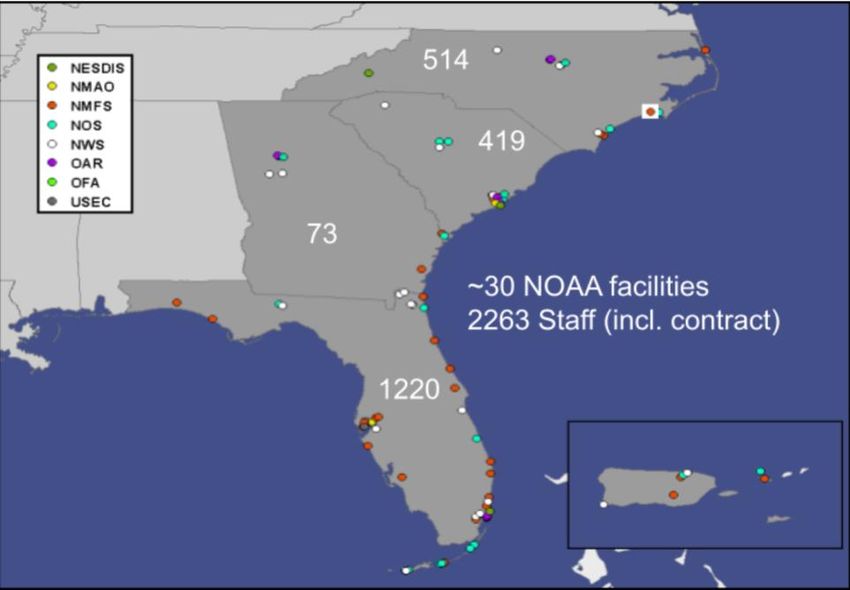
Preface
NOAA’s Southeast and Caribbean region is composed of the land areas of North and South
Carolina, Georgia, Florida, Puerto Rico (PR), and the U.S. Virgin Islands (USVI), and the
marine environment adjacent to these lands.

 The population in the region continues to increase, especially along the coast and Piedmont area
(Atlanta to Raleigh corridor). Of the almost 45 million people living in the four Southeast states,
approximately 38% reside in the coastal counties bordering the Atlantic Ocean. In PR and USVI,
a substantial number of the 3.8 million residents live in close proximity to the coast. While living
along the coast is highly desirable, this proximity comes with an elevated risk of natural hazards,
particularly tropical cyclones (hurricanes).

NOAA has over 2,300 staff and 30 facilities in the region, including workforce concentrations in
Beaufort/Morehead City, NC; Asheville, NC; Charleston, SC; Miami, FL; and St. Petersburg, FL
(see Fig. 1). NOAA also operates three National Marine Sanctuaries: Monitor NMS, offices in
NC and VA; Gray’s Reef NMS, Georgia; and Florida Keys NMS, Florida. A National Weather
Service (NWS) River Forecast Center (RFC) is located in Atlanta, while NWS Weather Forecast
Offices (WFOs) are distributed throughout the region. The NOAA Aircraft Operations Center is
located in Lakeland, FL, and two ships (Ronald Brown and Nancy Foster) claim Charleston, SC
as their home port. Other NOAA personnel, including fishery port agents and law enforcement
staff, are distributed along the entire coast.

                             NOAA Assets- Southeast & Caribbean

Figure 1. Locations of NOAA offices and NOAA partner offices in the Southeast and
Caribbean Region. Colors indicate NOAA Line Office or Line Office for partners.

In addition to NOAA employees and facilities, NOAA engages with and benefits from long-
term, close partnerships with state/territorial and university partners to address shared priorities,

                                                                                                        3
including six National Estuarine Research Reserves (NERRs), six Coastal Management
Programs, five Sea Grant Programs, and three Cooperative Institutes. Enhanced organizational
awareness and coordination between these assets is necessary to improve disaster resilience in
the Southeast and Caribbean Region.

NOAA’s Southeast and Caribbean Regional Team (SECART) works to improve NOAA’s
service delivery through enhanced communication and coordination across NOAA offices and
with partners. SECART has identified the goal of improving economic, environmental, and
social resilience of communities to weather, water, and climate impacts as a top priority.
SECART hosted a series of workshops to bring together NOAA offices across the region to
improve understanding of offices roles and responsibilities related to planning for, responding to,
and recovering from disasters. Workshop participants agreed that a “guide” to NOAA roles,
responsibilities, and resources related to disasters would itself be a valuable asset for the region.

This Guide to Integrated NOAA Disaster Resilience in the Southeast & Caribbean (Guide) is
designed to enhance coordination of NOAA’s diverse expertise, services, and resources when
preparing for, responding to, or recovering from a natural or anthropogenic emergency that
involves a threat or damage to human health or life, to property, or to the environment. In
addition, the Guide is intended to help raise awareness of NOAA roles and responsibilities and
promote coordination during these events with NOAA partners (listed above). This Guide
addresses emergencies such as:
                1. a large-scale / high-impact weather event including tsunami, hurricane, and
                   flooding;
                2. an oil spill, hazardous chemical release, or maritime accident;
                3. a large-scale fire event; and
                4. a radiological release.

For some emergencies, only one NOAA Line Office is needed to provide an effective response.
When two or more NOAA Line Offices are involved in a large-scale event, clear and efficient
communication and coordination are needed to simultaneously provide a high level of service
and efficiently use NOAA’s own expertise and resources.

The focus of this Guide is on communication and collaboration within and among NOAA’s Line
Offices, programs, and partners. Effective communication among federal, state, and local
agencies and within each NOAA Line Office is critical to response outcomes. The ultimate
objective of the Guide is to advance communication and better integrate Line Office capabilities
to support a “OneNOAA” response to emergency events. The Guide also addresses
communications with partners and stakeholders who will be engaged in NOAA’s efforts. The
Guide is not designed to challenge existing mandates or supersede existing policies.
The Guide was created in recognition that all disaster preparation, response, recovery, and
mitigation activities involving more than one NOAA Line Office can benefit from greater
knowledge of NOAA’s resources and more established communication protocols.

The process of developing the Guide was itself collaborative. Contributions from the National
Weather Service (NWS), National Ocean Service (NOS), National Marine Fisheries Service
(NMFS), National Environmental Satellite, Data, and Information Service (NESDIS), Office of

                                                                                                    4
Marine and Aviation Operations (OMAO), and the Office of Oceanic and Atmospheric Research
(OAR) were incorporated into the text. The findings from workshops and two tabletop exercises
also contributed to improving communication across Line Offices and fostered discussions that
were incorporated into the Guide.
The Guide is divided into three sections:
Section 1. This section provides background and contextual information on individual
NOAA Line Office or program capabilities and resources that can be leveraged during an
emergency response, including all phases of the disaster cycle (preparedness, response,
recovery, and mitigation or adaptation). Section 1 provides details regarding the NOAA
Line Office- and Staff Office-specific roles during a disaster, event, or incident. This
includes NOAA Line Office deployment and engagement protocols, and specific
emergency events that could occur in the Southeast and Caribbean region.
Section 2. This section provides an overview of federal response and recovery command
structures that dictate NOAA’s engagement in large-scale emergency response, extending
from initial deployment to follow-up assessments. This section describes the National
Response Framework (NRF), Emergency Support Functions (ESF), the National Incident
Management System (NIMS), the NOAA All-Hazards Concept of Operations Plan
(CONOPS), the Natural Resource Damage Assessment (NRDA), the National Disaster
Recovery Framework (NRDF), and the Recovery Support Federal Leadership Group
(RSFLG) and their roles.
Section 3. Section 3 provides the legal authorities and mandates that govern NOAA’s
responsibilities in response and recovery, including reimbursement for services rendered.
The section begins with legal mandates and authorities that govern the participation and
actions of NOAA Line Offices in an emergency response.
Appendix A - G. The appendices provide supporting information to sections 1-3 .
5Disaster Management Cycle Phases: NOAA is involved in all phases of the disaster cycle,
though responsibilities among Line Offices vary with type of disaster and the phase of the
disaster cycle. For this Guide, we use the definitions of the Disaster Management Cycle Phases
provided by Sandler and Schwab1.
● Preparedness: a state of readiness to respond to any emergency or disaster.
● Response: activities to meet the urgent needs of victims during or immediately following
a disaster
● Recovery: actions that begin after a disaster, after emergency needs have been met.
Recovery actions are designed to put the community back together or restore the
community to a new normal.
● Mitigation: any sustained action to reduce or eliminate long-term risk to people and
property from hazards and their effects.
Corrections and updates
If you have corrections or updates to information in this document, please send those (with
document section and page number) to region.secarib@noaa.gov
6SECTION I. NOAA LINE/STAFF OFFICE ROLES
Each Line Office has distinct resources and capabilities for responding to emergency events.
Beyond providing a brief background of relevant offices and programs, this section details
relevant services and expertise that each can bring to an emergency response for major events.
This section is organized by Event → Line office → Program/ Office involved in each phase of
the event.
Table 1: Directory of Line Office Programs / Roles for each Phase of Event, categorized by
event
Event Line Office Program/ Office
1.1 Hurricane, National Weather Weather Forecast Offices (WFOs)
Flooding, Tsunami, Service Preparedness
Earthquake (NWS) Response
Eastern Region Regional Operation Center
(ROC)
Preparedness
Response
Southern Region Regional Operation Center
(ROC)
Preparedness
Response
River Forecast Centers (RFCs)
Preparedness
Response
Recovery
Center Weather Service Units (CWSUs)
Preparedness
Port Meteorological Offices (PMOs)
Preparedness
Ocean Prediction Center (OPC)
Preparedness
Response
Tropical Analysis and Forecast Branch
(TAFB)
Preparedness
Response
Office of Response & Restoration (OR&R)
National Ocean Disaster Preparedness Program (DPP)
Service Preparedness
(NOS) Recovery
OR&R Emergency Response Division (ERD)
Response
7OR&R Marine Debris Program (MDP)
Response
Recovery
Office for Coastal Management (OCM)
Hurricane, Flooding, Preparedness
Tsunami, Earthquake Response
Recovery
Mitigation/Adaptation
Office of National Marine Sanctuaries
(ONMS)
NOS Preparedness
Response
Integrated Ocean Observing System (IOOS)
Preparedness
National Geodetic Survey / Remote Sensing
Division (RSD)
Preparedness
Response
Recovery
Southeast Regional Office (SERO) Protected
National Marine Resources (PR)
Fisheries Service Preparedness
(NMFS) Response
SERO Habitat Conservation (HC)
Preparedness
Response
SERO Sustainable Fisheries (SF)
Preparedness
Response
SERO National Environmental Policy Act
(NEPA)
Preparedness
Office of Habitat Conservation Restoration
Center (RC)
Response
Oceanic and National Sea Grant
Atmospheric Preparedness
Research
(OAR)
1.2 Oil Spills, National Ocean Office of Response and Restoration (OR&R)
Hazardous Chemical Service Assessment and Restoration Division (ARD)
Releases, and / or (NOS) Preparedness
Maritime Accidents Response
Recovery
OR&R Disaster Preparedness Program (DPP)
Preparedness
8Recovery
OR&R Emergency Response Division (ERD)
Response
Office of National Marine Sanctuaries
(ONMS)
Preparedness
Response
OAR National Sea Grant
Preparedness
NMFS Southeast Regional Office(SERO) Protected
Resources (PR)
Preparedness
Response
Southeast Regional Office (SERO) Habitat
Conservation (HC)
Preparedness
Response
Southeast Regional Office (SERO)
Sustainable Fisheries (SF)
Preparedness
Response
Office of Habitat Conservation Restoration
Center (RC)
Response
NWS Weather Forecast Offices
Preparedness
Response
Eastern Region (ER) Regional Operations
Center (ROC)
Preparedness
Response
Southern Region (SR) Regional Operations
Center (ROC)
Preparedness
Response
Ocean Prediction Center (OPC)
Preparedness
Response
Tropical Analysis and Forecast Branch
(TAFB)
Preparedness
Response
1.3 Large Scale Fire NWS Weather Forecast Offices (WFO)
Event Preparedness
Response
9Eastern Region (ER) Regional Operations
Center (ROC)
Preparedness
Response
Southern Region (SR) Regional Operations
Center (ROC)
Preparedness
Response
OAR National Sea Grant
Preparedness
1.4 Radiological NWS Weather Forecast Offices (WFO)
Release Preparedness
Eastern Region (ER) Regional Operations
Center (ROC)
Preparedness
Southern Region (SR) Regional Operations
Center (ROC)
Preparedness
OAR National Sea Grant
Preparedness
NOS Office of Response & Restoration Disaster
Preparedness Program (OR&R DPP)
Preparedness
OR&R Emergency Response Division (ERD)
Response
NMFS Southeast Regional Office(SERO) Protected
Resources (PR)
Preparedness
Response
Southeast Regional Office(SERO) Habitat
Conservation (HC)
Preparedness
Response
Southeast Regional Office(SERO)
Sustainable Fisheries (SF)
Preparedness
Response
Southeast Regional Office(SERO)National
Environmental Policy Act (NEPA)
Preparedness
Office of Habitat Conservation Restoration
Center (RC)
Response
101.1 Large Scale or High Impact Event: Hurricane, Flooding, Earthquake, Tsunami
Event response may involve multiple agencies, including the Federal Emergency Management
Agency (FEMA), United States Environmental Protection Agency (USEPA), U.S. Army Corps
of Engineers (USACE), U.S. Geological Survey (USGS), National Guard, U.S. Bureau of
Reclamation (USBR), U.S. Department of Transportation (USDOT), and U.S. Coast Guard
(USCG) at the federal level, plus state and local emergency management officials, engineers, and
water managers. In the aftermath of any large-scale and/or high-impact environmental event,
FEMA is normally the primary federal agency to manage disaster response and recovery per the
National Disaster Response and Recovery Frameworks (see appendix). NOAA’s weather
forecasting and tsunami role in the lead-in to a major event is clear-cut. In the event aftermath,
however, NOAA has significant capacity to provide decision support to agencies involved in
rescue, clean-up, and recovery operations. This is particularly true of weather and tsunami
support, but may also include other activities to address injury to public trust resources from the
event impacts or in the event of a release of oil or hazardous materials, and assistance if needed.
National Weather Service (NWS)– The NWS organizationally consists of a mix of local,
regional, and national forecast centers across the United States and its territories. These include
nine national centers that provide expertise in environmental modeling and severe storm,
tropical, aviation, hydrometeorological, climate, space weather, and ocean forecasting. In
addition to regional-level headquarters and national centers, the NWS Southeast and Caribbean
Region is served by some 16 Weather Forecast Offices, the National Hurricane Center, the
Tropical Analysis and Forecast Branch, and the Caribbean Tsunami Warning Program office.
The NWS Operations Center provides timely Impact-Based Decision Support Services (IDSS) to
meet the evolving needs of NWS partners and stakeholders and supports agency readiness by
proactively collaborating and facilitating the exchange of critical information, setting operational
posture, and briefing leadership. The Southeast and Caribbean region is served by the Southern
and Eastern Regional Operations Centers and they are supported by the National Operations
Center (NOC). The Regional Operations Centers are responsible for overseeing and coordinating
NWS emergency response efforts during high-impact events. ROCs serve an Emergency
Operations Center (EOC) function when any NWS office is involved in an ICS deployment.
Together, national, regional, and local NWS resources provide diverse support services during an
emergency response. NWS capabilities include general seven-day forecasts for temperature; dew
point temperature; relative humidity; Quantitative Precipitation Forecast (QPF) for rain, snow
and ice; wind speed and direction; weather type; precipitation probability; sky cover; wave
height; apparent temperature; and river stage. These forecasts are updated on a 24/7 basis. All of
these forecasts and warnings are available to the general public on NWS web pages and
graphically and digitally through the NWS National Digital Forecast Database (NDFD).
More importantly, in addition to extensive public forecast and warning information, NWS has
the capacity to forecast the previously listed pertinent weather and environmental elements, plus
others, at a level of detail and sophistication far beyond what is available to the general public.
These capacities are reserved mostly for emergency situations involving local, state, and federal
government response. These situations include tropical cyclones, tsunamis, oil spills, rangeland
and forest fires, urban fires, airborne chemical releases, radiological releases, and search and
rescue efforts. Examples of advanced decision-support products and services include hourly
11snowfall rate probabilities for road and runway crews; high resolution wave spectra (max waves)
and return frequency for marine operations; hourly probabilistic winds, mixing height and plume
forecasts for fires, airborne releases and aviation operations; detailed river stage and streamflow
forecasts for flood operations and inland river spills; and extreme heat/cold and thunderstorm
forecasts for outdoor recovery operations. Typically, these are provided by request through an in-
person briefing, a webinar or telephone briefing, or web delivery. In the event that NOAA
personnel outside NWS, including the Scientific Support Coordinators (SSC), are asked to
provide weather information, they are encouraged to consult with NWS. NWS has extensive
forecast datasets that are not automatically posted. NWS employees can readily access, interpret,
and disseminate this higher-level information to the SSC and emergency responders, with the
likely outcome of improved response decision-making and actions.
The large number of WFOs—122 across the nation—makes NWS explicitly community-based.
WFOs in particular communicate regularly with state and local agencies, media, and local
Emergency Managers, which means that during a large emergency event, they are likely to be
contacted before other NOAA Line Offices. A 24/7 operation and presence throughout the region
also allows NWS personnel to quickly deploy to almost any Emergency Operations Center
(EOC) or Incident Command Post (ICP). NWS also maintains a cadre of trained Incident
Meteorologists (IMETs) or Emergency Response Specialists/Meteorologists (ERS/ERM)
specifically for emergency response purposes. While these positions were originally intended to
deploy for fires, personnel are trained and equipped to respond to other natural or human-caused
incidents as well.
The local WFOs are among the primary responders from within NWS; they are responsible for
forecasting weather and water conditions that influence recovery and response efforts. National
Tsunami Warning Center (NTWC), Pacific Tsunami Warning Center (PTWC), International
Tsunami Information Center (ITIC), and the Caribbean Tsunami Warning Program are
responsible for providing real-time tsunami information via text and graphical products to
include watches and warnings for tsunamis supporting emergency managers and first responders.
During and after large-scale/high-impact weather events, NWS personnel can provide on-site
decision support at Emergency Operations Centers (EOCs) for extended periods. These
personnel are often provided from the affected WFO, but may also include emergency response
personnel from other offices. This is coordinated through the NWS Eastern and Southern Region
ROCs.
National Ocean Service (NOS)– The NOS consists of several program offices in this region.
The Office of Response and Restoration Emergency Response Division (ERD) should be
contacted during significant weather events where there is an occurrence or risk of oil or
hazardous materials being released into coastal or inland waterways. The Disaster Preparedness
Program provides coordination of personnel, products, and resources within NOS to ensure that
NOS resources are maximized. They have also developed an internal NOAA, NOS Disaster
Coordination Dashboard, that provides quick access to active reports, documents, and tools
needed during disaster responses or exercises. They serve as a coordination platform for NOS
staff and offices. The Marine Debris Program staff provides scientific support from defined core
expertise and services based on requests from responding agencies, or self-activation in severe
debris events. The Marine Debris program has developed state Marine Debris Emergency
12Response Guides which can be employed during response. In addition, MDP Regional
Coordinators and staff will coordinate with ESF-10 response and may also provide assistance in
marine debris mapping.
Office for Coastal Management (OCM) may become involved to assess impacts to state and
territorial partners including safety of staff, the operational status of their programs and damage
to any NOAA funded property or equipment, as well as receive updates on the impacts to coastal
resources under their management. OCM should be contacted for those wishing to conduct or
obtain assessments of coral, mangrove, submerged aquatic vegetation (SAV), dunes, or other
coastal resources after an event in order to coordinate with any existing efforts. In addition to
receiving updates, OCM (at least CRCP) has been heavily engaged in emergency response (i.e.,
triage) and damage assessment of coral reefs immediately after storms. OCM provides staff
support (in the field and FEMA office) during the ESF phase. This has been actual in-the-water
work.
Office of National Marine Sanctuaries (ONMS) may become involved in either assessing
impacts to NOAA trust resources or as a provider of vessels of opportunity. For an oil spill,
participation assumes operations outside areas of active oiling. In some instances, larger ONMS
vessels have been used as temporary office/shelter space for employees and partners.
The primary mission of the Office of Coast Survey (OCS) assets in an emergency is to respond
to requests from the USCG D7 Captain of the Port (COTP) in collaboration with the maritime
pilots, USACE, and regional port authorities’. Requests typically include providing one or more
hydrographic survey assets capable of detecting shoaling and obstructions using Multibeam and
Side-Scan Sonar systems. Survey requests will vary from approach channels in the Open Ocean
to navigable inner harbor areas. The primary reason the COTP will request NOAA OCS support
following a storm is to help re-open a port by verifying the channels and navigable waterways
are safe for navigation from new and unknown shoaling and obstructions. During field
operations NOAA assets will also verify ATON’s are on-station and serving their intended
purpose as well as reporting other hazards, such as floating or exposed debris. NOAA assets will
generally pre-stage prior to the storm making landfall and be ready to start field work as soon as
the waterway is accessible and conditions are safe. Field units normally report preliminary
findings of general shoaling and obstructions to the COTP daily during the response and submit
final reports and products within 2-3 days following acquisition.
The National Geodetic Survey (NGS) acquires and rapidly disseminates a variety of spatially-
referenced remote-sensing datasets to support homeland security and emergency response
requirements.
National Marine Fisheries Service (NMFS)– Hurricane and flood events can lead to multiple
long term impacts which may involve NMFS offices. Impacts could include releases of
hazardous substances, triggering the Damage Assessment, Remediation and Restoration Program
(DARRP); strandings of marine mammals or sea turtles, managed by Protected Resources; losses
to fisheries, leading to a fisheries disaster declaration and Sustainable Fisheries involvement; or
habitat impacts that may be addressed either through restoration (Restoration Center) or
consultations (SERO Habitat Conservation Division and Protected Resources).
13The Habitat Conservation Division (HCD) provides technical advice and recommendations for
minimizing or addressing the adverse effects of emergency response activities on federally
managed resources. They assist with essential fish habitat consultations where response and
recovery activities may affect essential fish habitat, and participate in FEMA's Unified Federal
Review to assist with streamlining the permitting process.
The Protected Resources Division (PRD) oversees, coordinates, and authorizes stranding
network responses, including rescues of animals that are washed inland due to storm surge, and
may implement (or alleviate) certain regulatory requirements on a temporary basis to protect
trust resources or assist regulated fishermen following a severe weather event. This includes
exempting affected fisheries from turtle excluder device (TED) requirements on a temporary
basis if TEDs are being clogged by debris and authorizing affected fishermen and dealers to use
paper-based in lieu of electronic transactions if electronic systems go offline. PRD also consults
on response and recovery actions which may impact listed species or marine mammals, and they
participate in FEMA's Unified Federal Review.
The Sustainable Fisheries Division evaluates information provided by the states in support of
fishery disaster determination requests and works with affected entities to distribute any
Congressionally appropriated funds consistent with statutory requirements and conditions of the
appropriation.
NMFS also houses the Restoration Center (RC). The RC is part of the DARRP matrix that
provides technical expertise in assessing injuries to fish and wildlife, as mandated by Oil
Pollution Act (OPA) and Comprehensive Environmental Response, Compensation, and Liability
Act (CERCLA). The RC also plans, implements, and funds coastal habitat restoration throughout
the Southeast Region, often through regional partnerships. In addition to providing financial and
technical assistance to remove dams and barriers, construct fish passages, and remove invasive
species, the RC also provides resources to clean up marine debris and restore coastal wetlands.
Oceanic and Atmospheric Research (OAR)– The Atlantic Oceanographic and Meteorological
Laboratory (AOML), a federal research laboratory, is part of NOAA's Office of Oceanic and
Atmospheric Research (OAR), located in Miami, Florida. AOML's research spans hurricanes,
coastal ecosystems, oceans and human health, climate studies, global carbon systems, and ocean
observations. OAR may become involved in a response in a consultant role, applying resources
and technologies to support National Weather Service response and recovery needs. These can
be in the form of hydrologic support from the Weather Prediction Center at the National Centers
for Climate and Weather Predictions, weather science support from the National Severe Storms
Lab (NSSL) in Norman, Oklahoma, or the Earth System Research Laboratory (ESRL) in
Boulder, Colorado.
National Environmental Satellite, Data and Information Service (NESDIS)– offers, as
needed, high resolution Rapid Scan Observations satellite support services that can be used to
support tropical cyclones and severe weather events among other services. NESDIS is
responsible for providing secure and timely access to global environmental data and information
14from satellites and other sources to both promote and protect the Nation’s environment, security,
economy and quality of life.
The increasing number of satellites helps provide the high definition images and data needed
during incidents and disasters. The launch of GOES-S, was a game-changer for weather forecasts
in the Western U.S.. The capabilities provided by the satellite include three times more data at
four times better resolution, and scanning five times faster. The satellite also provides high-
resolution imagery to better detect wildfires and hot spots. The Search And Rescue Satellite
Aided Tracking (SARSAT) system is part of a 24x7 International search and rescue satellite
program called COSPAS_SARSAT. This system detects emergency signals, and provides
coordinated response to emergencies worldwide.
NESDIS National Centers for Environmental Information (NCEI) provides the World’s largest
archive of environmental data from U.S. and foreign sources. They also maintain and publish the
NOAA Extreme Weather Information Sheets (NEWIS). NCEI created these sheets to help
coastal residents of states and the two U.S. territories that are particularly at risk from tropical
storms and hurricanes. These provide detailed contact phone and website contact information for
county, state, and national resources during an event.
For the Region, NOAA’s NESDIS is supported by the Cooperative Institute for Satellite Earth
Systems Studies (CISESS) at the University of Maryland College Park (UMD) and North
Carolina State University (NCSU). CISESS contributes to NOAA mission directed research
leading to greater observation, understanding, and prediction of the global Earth System.
CISESS and NESDIS provide a wide variety of real-time, high-resolution satellite imagery and
derived products for the Region that may be useful in any emergency response situation (e.g.,
fire monitoring). In addition to this, the NESDIS GOES-East (satellite weather imagery)
provides satellite data to the NWS Regions. The NWS also receives satellite data across the
region from ground receipt satellite dishes that are supported locally and through support from
CISESS.
1.1.1 Preparedness– NWS, NOS, NMFS, OAR
1.1.1A NWS–
1.1.1A.1 WFOs
● Interagency Dependencies: Numerous with local, state, and federal agencies.
Preparation will depend on office and potential for impacts. Just prior to a system,
NWS offices will begin coordination with emergency management on track,
intensity, timing, and confidence level.
● Products/Resources: NWS supports National Hurricane Preparedness week and
most states also have their own week. Work with local, state, and federal partners
to urge people to prepare through the use of NOAA weather radio, social media,
broadcast/print media, etc. Several days in advance of a system, work with
emergency management providing input for critical decisions points (e.g.
evacuations, interstate "turn-arounds", shelters, etc.). The local WFO Integrated
Warning Team (IWT) brings together emergency managers, broadcast and print
media, amateur radio network controllers, government and special district
15officials, and the National Weather Service with the goal of finding the best ways
to communicate a consistent warning message during an event.
Office Contact2 Source
WFO Wakefield, VA Jeff Orrock www.weather.gov/akq
WFO Blacksburg, VA Douglas Butts www.weather.gov/rnk
WFO Newport, NC David Glenn www.weather.gov/mhx
WFO Wilmington, NC Mark Willis www.weather.gov/ilm
WFO Raleigh, NC Jonathan Blaes www.weather.gov/rah
WFO Greer, SC Steve Wilkinson www.weather.gov/gsp
WFO Columbia, SC Rich Okulski www.weather.gov/cae
WFO Charleston, SC Michael Emlaw www.weather.gov/chs
WFO Atlanta, GA Keith Stellman www.weather.gov/ffc
WFO Jacksonville, FL Scott Cordero www.weather.gov/jax
WFO Melbourne, FL Dave Sharp www.weather.gov/mlb
WFO Miami, FL Pablo Santos www.weather.gov/mfl
WFO Key West, FL Chip Kasper www.weather.gov/key
WFO Tampa Bay, FL Brian LaMarre www.weather.gov/tbw
WFO Tallahassee, FL Felicia Bowser www.weather.gov/tae
WFO Mobile, AL Jeff Medlin www.weather.gov/mob
WFO San Juan, PR Roberto Garcia www.weather.gov/sju
1.1.1A.2 NWS– Eastern Region Operations Center (ER ROC)
● Role/Procedures: First contact for NWS Offices in NC and SC
● Contact: David Manning
1.1.1A.3 NWS– Southern Region Operations Center (SR ROC)
● Role/Procedures: First contact for NWS Offices in GA, FL, PR and VI.
● Contact: Jennifer McNatt
1.1.1A.4 NWS– River Forecast Centers (RFCs)
● Interagency Dependencies: Coordination with NWS offices and partners to
account for any last minute hydrologic changes. Coordinate with WPC and NWC
on predicted rainfall amounts.
● Products/Resources: In the days and hours before a storm, begin forecasting
expected river levels and timing of crest(s) through the river and lake basins.
16Office Contact Source
Southeast RFC John Schmidt https://www.weather.gov/serfc
Lower Mississippi RFC Suzanne Van Cooten https://www.weather.gov/lmrfc
Mid-Atlantic RFC Peter Anhert https://www.weather.gov/marfc
1.1.1A.5 NWS– Center Weather Service Units (CWSUs)
Office Contact Source
Washington CWSU Richard Winther https://www.weather.gov/zdc/
Atlanta CWSU Charles “Chip” https://www.weather.gov/ztl/
West
Jacksonville CWSU Brian Schroeder https://www.weather.gov/zjx/
Miami CWSU Liam Lynam https://www.weather.gov/zma/
1.1.1A.6 NWS– Port Meteorological Offices (PMOs)
Office Contact
Charleston, SC PMO Tim Kenefick
Timothy.Kenefick@noaa.gov
Jacksonville, FL PMO Rob Niemeyer
pmojax@noaa.gov
Miami, FL PMO David Dellinger
pmomia@noaa.gov
New Orleans, LA PMO Rusty Albara
rusty.albara@noaa.gov
1.1.1A.7 NWS– Ocean Prediction Center
Ocean Prediction Center (OPC) originates and issues marine warnings and
forecasts, continually monitors and analyzes maritime data, and provides
guidance of marine atmospheric variables for purposes of protection of life and
property, safety at sea, and enhancement of economic opportunity.
● Interagency Dependencies: Primarily with federal and international
partner agencies and organizations.
● Products/ Resources: Provides over 150 products each day for the safety
of life at sea, including for much of the north Atlantic north of 31N, and
with high seas warnings west of 35W.
● Contact: Darin Figurskey, Ocean Forecast Branch Chief
(darin.figurskey@noaa.gov)
171.1.1A.8 NWS– Tropical Analysis and Forecast Branch (TAFB)
Tropical Analysis and Forecast Branch (TAFB) is an integral part of
the National Hurricane Center and performs forecasting, outreach, and
support functions, covering the waters beyond 60 nautical miles from
shore. TAFB provides daily forecasts, as well as episodic support for the
USCG in these offshore waters.
● Interagency Dependencies: Primarily with federal and international
partner agencies and organizations.
● Products/ Resources: The TAFB forecasts cover an area which covers
10,000,000 square nautical miles and produces over 100 products per day.
TAFB products include but are not limited to the following: High Seas
Marine Forecasts over the tropics and subtropics, Offshore Waters Marine
Forecasts over the tropics and subtropics, Tropical Weather Discussions
over the tropics and subtropics, Surface weather analyses and forecasts
over the tropics, subtropics, and mid-latitudes, and Experimental Gridded
Marine Forecasts over the tropics and subtropics.
● Contact: Chris Landsea (chris.landsea@noaa.gov)
1.1.1B.1 NOS– OR&R DPP
Disaster Preparedness Program (DPP) prepares NOS and partners to
respond to disasters through trainings, exercises, planning, and continuous
improvement. NOAA's Disaster Response Center (part of the DPP) is a
regional hub for disaster preparedness that was created to aid in NOAA’s
coordination and emergency planning in the Gulf of Mexico and enhance
this preparedness culture. The DRC hosts experts in oil and chemical spill
response; environmental damage assessment; habitat conservation and
restoration planning; marine debris; and navigation management. DPP
provides coordination within NOS to ensure that NOS resources are
maximized. The DPP holds planning workshops targeting regional
preparedness gaps. In addition, the DPP works closely with OCM and the
National Earnestine Research Reserves (NERRS) to develop and train
disaster response plans. They also coordinate NOS storm preparation and
response activities such as:
● Interagency Dependencies: NOS partner agencies and organizations
● Products/Resources: Science of Coastal Natural Disasters class,
NOAA-Specific ICS 300 course
● Contact: Kate Wheelock (kate.wheelock@noaa.gov)
1.1.1B.2 NOS– OCM
DATA: The Office for Coastal Management (OCM) Digital Coast assists
NOAA Offices as well as state, territorial, and community partners by
providing access to elevation and land cover data and imagery that can be
used to improve planning for and implementation of adaptation strategies to
reduce future impacts and enhance community resilience along the coast. For
18example, OCM assists NOAA’s National Hurricane Center by providing
underlying elevation models and sea level rise data, which is used to develop
storm surge forecast maps.
● Products/Resources: Historical hurricane tracks, Topo Bathy LIDAR,
land cover, imagery, economic data, potential sea level rise data;
Quick Ref - Additional Data Needs and Information for a Community
Risk and Vulnerability Assessment
● Contact: Miki Schmidt (nicholas.schmidt@noaa.gov), Jeff Payne
(jeff.payne@noaa.gov) for Hurricane
TOOLS: OCM's Digital Coast provides access to a number of its own and
others tools that can give the public a visual idea of where flooding is possible
from CAT I-V storms along their coasts, and what types of critical
infrastructure is potentially vulnerable (e.g., Coastal Flood Exposure Mapper)
and provides links to other agency tools (e.g., USGS Flood Event Viewer)
● Products/Resources: Coastal Flood Exposure Mapper
● Contact: Miki Schmidt
FUNDING: States and territories may use Coastal Zone Management Act
(CZMA) funding to undertake preparedness planning or projects.
STATE AND TERRITORIAL COASTAL ZONE MANAGEMENT
(CZM) PROGRAMS: All 6 Coastal States and territories in the Southeast &
Caribbean Region (NC, SC, GA, FL, USVI, and PR) have developed federally
approved coastal management programs making them eligible for federal
CZMA funding which may include planning, regulatory, and acquisition
activities to mitigate coastal hazards and enhance resilience. Several state
Coastal Programs have worked with OR&R's Marine Debris Program to
develop Marine Debris Reduction Guidance Plans. OCM works closely with
these programs to provide coordination, communication, and response
capacity. The National Coastal Resilience Fund, executed in partnership with
NOAA OCM, has funded projects in all states and territories to enhance
disaster resilience using natural infrastructure, some with the Coastal
Management Program as the recipient.
● Products / Resources: Florida, Marine Debris Reduction Guidance
Plan
● Contact: Laura Petes, NOAA/OCM laura.petes@noaa.gov; Becky
Prado, FL DEP ebecca.prado@dep.state.fl.us
NATIONAL ESTUARINE RESEARCH RESERVE (NERR)
PROGRAMS: There are six NERRs in the Southeast & Caribbean Region.
Several Reserves have developed disaster preparedness plans to reduce
damages to reserve facilities, equipment, and other assets. In the past, some
NERRs have served as derelict vessel or marine debris temporary storage
areas.
19CORAL REEF CONSERVATION PROGRAM: Coral Reef Management
positions located on site in Florida, US Virgin Islands (USVI), and Puerto
Rico provide coordination, communications, and response capacity for local
coral and CZM programs and related NOAA programs and are able to
contribute to recovery planning and implementation activity.
● Contact: Jennifer.Koss@noaa.gov, Harriet.Nash@noaa.gov, or
Dana.Wusinich-Mendez@noaa.gov
1.1.1B.3 NOS– Office of National Marine Sanctuaries (ONMS)
PLANNING: ONMS Headquarters (HQ) will review existing All Hazards
and Continuity of Operations (COOP) plans for each site. COOP Alternate
Site plans need further development for the entire ONMS system. All sites
should review site-specific elements within the USCG-EPA Area Contingency
Plans that are part of the Regional Response Plans. ONMS HQ will also
review how to support relocation of non-federal personnel for extended
periods and evaluate the feasibility of extended evacuation and or recovery
periods.
● Interagency Dependencies: Evacuation and re-entry is dependent on
state and local authorities.
● Contact: Lisa Symons (Lisa.Symons@noaa.gov)
FORWARD STAFFING PLATFORM: ONMS can provide a forward
staffing component for other NOAA and NOS services during preparation for
a significant weather event. This may require deployment of ONMS personnel
in county and state EOCs.
● Interagency Dependencies: Request of support may come from state
or federal (FEMA, USCG) agencies; USCG, OR&R, NMFS
Restoration Center, GC, DOI (NPS & USFWS) state trustees
● Products/Resources: Technical expertise in marine and coastal
resources and NOS and NOAA products and services.
● Contact: Lisa Symons (Lisa.Symons@noaa.gov)
1.1.1B.4 NOS– Integrated Ocean Observation Systems (IOOS)
DATA AND IOOS DATA PORTALS: US Integrated Observation System
Program (IOOS) works closely with its Caribbean (CARICOOS Latest
Conditions and Forecast) and Southeast U.S. (SECOORA https://secoora.org/)
regional associations to provide ocean observations before, during, and after
storms using high-frequency radars and gliders. Both CARICOOS and
SECOORA developed data portals and web pages for each storm.
● Products/Resources: Data dashboards and storm centers are
customized on each Regional Association (RA) site (links under
"Source"). Additionally the complete RA and U.S. IOOS data
catalogs are available to meet additional data needs.
201.1.1B.5 NOS– National Geodetic Survey / Remote Sensing Division: NGS
participates in planning meetings, provides technical and operational
expertise, and coordinates with other agencies.
● Products / Resources: Pre-event Oblique Aerial Imagery, LIDAR
● Contact: Mike Alasken (mike.alasken@noaa.gov)
1.1.1C.1 NMFS– Southeast Regional Office (SERO) Protected Resources
Program (PR)
REGULATORY: NMFS provides technical advice and recommendations,
including Best Management Practices and other guidance, for minimizing or
addressing the adverse effects of emergency response activities on our trust
resources. Federal action agencies, which fund, permit, or carry out activities
that may affect threatened or endangered species or their critical habitat are
required to consult with NMFS regarding the potential impacts of their actions
on these trust resources. SERO offers expedited consultations during urgent
emergency situations involving an act of God, disasters, casualties, and
national defense or security emergencies. Included are response activities,
which must be taken during hazardous material clean up, response to natural
disasters, or actions to protect public safety. These emergency consultations
are intended to enable Federal agencies to complete their critical missions in a
timely manner while minimizing the adverse effects of response activities on
our trust resources. They recognize that public safety takes precedence if there
is a conflict between the two. Expedited consultation services for remedial
actions or mitigation activities that are taken after an emergency situation has
ended that are intended to address damages that occurred during the
emergency are not offered. Emergency Endangered Species Act (ESA)
consultations can be initiated by emailing a completed Emergency
Consultation Request Form to SERO at
nmfs.ser.emergency.consult@noaa.gov. Contact should be made by Federal
agencies early in response planning, but may consult after-the-fact, if
consultation on an expedited basis is not practicable before taking an
emergency response action.
● Interagency Dependencies: There is a standing ESA Emergency
Consultation MOA for Oil and Hazmat Spills signed by DOI, FWS,
NOAA, NMFS, EPA and USCG. This MOA provides the structure for
ESA consultation for Spill Response and Planning
(https://www.nrt.org/sites/2/files/ESAMOA.pdf).
● Products/Resources: Emergency ESA consultations, including
technical advice and suggested mitigation (email request form online
at
http://sero.nmfs.noaa.gov/protected_resources/section_7/emergency_c
onsultation/documents/nmfs_emergency_consultation_form.pdf )
● Contact: EMAIL: nmfs.ser.emergency.consult@noaa.gov;
TELEPHONE: 727-824-5312 (only staffed during business hours)
21REGULATORY: In the event of an emergency, NOAA Fisheries may
implement (or alleviate) certain regulatory requirements on a temporary basis
to protect public health or trust resources, or assist regulated fishermen.
Specifically, we may exempt affected fisheries from turtle excluder device
(TED) requirements. With few exceptions, shrimp trawlers operating in Gulf
of Mexico and South Atlantic waters must have an approved TED installed in
each net rigged for fishing. However, NOAA Fisheries can authorize shrimp
vessels to use tow time restrictions in lieu of TEDs following hurricanes or
other severe weather events if we determine that trawling with TED-equipped
nets is impracticable, effectively impeding their conservation benefits. Such
an authorization would take the form of an emergency rulemaking that could
be effective for up to 30 days and may be renewed for additional 30-day
periods, if the conditions necessitating the imposition of tow-time restrictions
continue to exist. The appropriate state or federal fishery officials should
make requests for temporary TED exemptions where the affected shrimp
fishery is located to the Southeast Regional Administrator, Dr. Andy
Strelcheck.
● Products/Resources: Turtle Excluder Device (TED) exemptions
1.1.1C.2 NMFS– Southeast Regional Office (SERO) Habitat Conservation
Program (HC)
Federal action agencies which fund, permit, or carry out activities that may
affect essential fish habitat (EFH) are required to consult with NMFS
regarding the potential impacts of their actions on these trust resources.
Emergency EFH consultations can be initiated by emailing a completed
Emergency Consultation Request Form to SERO at
nmfs.ser.emergency.consult@noaa.gov. Contact should be made by Federal
agencies early in response planning, but may consult after-the-fact, if
consultation on an expedited basis is not practicable before taking an
emergency response action.
● Products/Resources: Emergency EFH consultations, including
technical advice and suggested mitigation (email request form online
at
http://sero.nmfs.noaa.gov/protected_resources/section_7/emergency_c
onsultation/documents/nmfs_emergency_consultation_form.pdf)
● Contact: EMAIL: nmfs.ser.emergency.consult@noaa.gov;
TELEPHONE: David Dale, EFH Coordinator (727-551-5736; only
staffed during business hours)
1.1.1C.3 NMFS– Southeast Regional Office (SERO) Sustainable Fisheries
Program (SF)
Regulatory: Establish fishery closures or exempt affected fisheries from
electronic recordkeeping and reporting requirements. Through emergency
rulemaking, NMFS closes and reopens areas to fishing activities, as needed, to
22protect public health. Any such closure could remain in effect until the
circumstances that created the emergency no longer exist if the public has an
opportunity to comment on the closure and the Secretary of Health and
Human Services concurs with the action. If NMFS determines catastrophic
conditions exist, authorization of affected fishermen and dealers to use paper-
based in lieu of electronic transactions for basic required functions of our
commercial Individual Fishing Quota (IFQ) program until those conditions
cease. Similar allowances for other NOAA regulated fisheries programs are
pending.
● Products/Resources: Fishery disaster assistance
● Contact: (727) 824-5305 (this number is only staffed during business
hours)
1.1.1C.4 NMFS– Southeast Regional Office National Environmental Policy
Act Program (NEPA)
REGULATORY: Advises regarding NEPA compliance for response-related
activities for which NMFS is the federal action agency.
● Interagency Dependencies: n/a
● Products/Resources: NEPA advice
● Contact: Noah Silverman, NEPA Coordinator (727-824-5353); only
staffed during business hours
1.1.1D.1 OAR– National Sea Grant Program
Role: There are five Sea Grant Programs in the Southeast & Caribbean
Region. The sea grant programs support integrated research, education, and
extension programs that align with our mission of generating and applying
science-based information on issues and opportunities to enhance the practical
use and conservation of coastal and marine resources to foster a sustainable
economy and environment.
● Regional Contact: Lacy.Alison@noaa.gov
North Carolina Sea Grant: based out of North Carolina State University, but
has offices in Manteo, Morehead County, and Wilmington.
● Contact: https://ncseagrant.ncsu.edu/about-us/our-team/
South Carolina Sea Grant: The Consortium member institutions are
Clemson University, Coastal Carolina University, College of Charleston,
Medical University of South Carolina, S.C. Department of Natural Resources,
S.C. State University, The Citadel, and University of South Carolina
● Contact: (843)953-2078 https://www.scseagrant.org/staff-directory/
Georgia Sea Grant: Based out of the University of Georgia.
● Contact: https://gacoast.uga.edu/about/about-us/staff-list/
23Florida Sea Grant: Based out of the University of Florida (UF - Gainesville),
but with funded PIs and extension agents in coastal counties around the state
● Contact: https://www.flseagrant.org/faculty-and-staff/
Puerto Rico Sea Grant: Based out of the University of Puerto Rico
Mayaguez campus, but works island-wide and in the USVI
● Contact: https://seagrantpr.org/about-the-sea-grant-program/staff/
1.1.2 Response– NWS, NOS, NMFS
1.1.2A.1 NWS - Weather Forecast Offices (WFOs)
● Interagency Dependencies: Depending on location/track of system—
local, state, and federal emergency management support fully
engaged. Coordination between NHC and NWS offices occurs at
regular intervals along with coordination between NWS offices for
state emergency managers. Many NWS offices coordinate for multiple
states.
● Products/Resources: Numerous briefings ranging from Emergency
Operations Centers (EOCs) to conference calls and broadcast/print
media. Watches, warnings, and advisories continue. High danger time
due to system impacts (e.g. hurricane winds, tornadoes, tropical
rainfall, etc.) continuing and emergency response personnel wanting to
get out to evaluate the situation. Begin producing maps for system
attributes (e.g. highest winds, surge, rainfall, etc.).
1.1.2A.2 NWS– Eastern Region Operations Center (ER ROC)
See Section 1.1.1A.2
1.1.2A.3 NWS– Southern Region Operations Center (SR ROC)
See section 1.1.1A.3.
1.1.2A.4 NWS– River Forecast Centers (RFCs)
● Interagency Dependencies: Interaction with NWS offices for ground
truth and forecasting for rainfall and runoff to propagate through the
river basins. Numerous hydroelectric operations will also impact the
amount of water through the system. Dam operators may run above
flood levels if water level threatens dam structure.
● Products/Resources: Numerous briefings ranging from Emergency
Operations Centers (EOCs) to conference calls and broadcast/print
media. Watches, warnings, and advisories continue. High danger time
due to system impacts (e.g. hurricane winds, tornadoes, tropical
rainfall, etc.) continuing and emergency response personnel wanting to
24get out to evaluate the situation. Begin producing maps for system
attributes (e.g. highest winds, surge, rainfall, etc.).
1.1.2A.5 NWS– Ocean Prediction Center (OPC)
Ocean Prediction (OPC)
See 1.1.1A.7
1.1.2A.6 NWS– Tropical Analysis and Forecast Branch (TAFB)
See 1.1.1A.7
1.1.2B.1 NOS– OR&R Emergency Response Division (ERD)
Emergency Response Division (ERD) hosts training for responding to oil
spills and hazmat emergencies, serves as a member of the Interagency
Coordinating Committee on Oil Pollution Research, participates in Regional
Response Teams for local disaster planning, and maintains tools that can be
used for preparedness such as Environmental Sensitivity Index (ESI) maps
and data. OR&R Scientific Support Coordinators (SSCs) will embed with US
Coast Guard Incident Command Centers/Posts (ICC/ICP) to assist with
hazardous materials response efforts. ERD Scientific Support Coordinators
(SSCs) provide scientific support to the Federal On-Scene Coordinator, either
remotely or at the Incident Command Center/Post (ICC/ICP), to carry out the
most effective clean-up operations. Tools including ESI maps, CAMEO, and
GNOME are used to provide support. ERMA is used as the Common
Operating Picture (COP) at Incident Command Posts.
● Interagency Dependencies: US Coast Guard, USACE, FEMA, and
other federal, state, and local agencies.
● Products/Resources: Scientific Support Coordinators (SSCs),
Environmental Sensitivity Index Maps and data (ESIs), CAMEO,
GNOME, ADIOS, Science of Oil Spills/Chemical Releases classes,
Shoreline Cleanup and Assessment Technique (SCAT) class.
● Contact: Brad Benggio (brad.benggio@noaa.gov)
1.1.2B.2 NOS– OR&R Marine Debris Program (MDP)
Marine Debris Program (MDP) facilitates a marine debris response
planning effort in coastal states to develop guides that outline existing
response structures at the local, state, and federal levels. These guides assist
with a coordinated, well-managed, and immediate response to waterway
debris incidents impacting the state. MDP provides scientific support from
defined core expertise and services based on requests from responding
agencies, or self-activation in severe debris events.
● Interagency Dependencies: US Coast Guard, USACE, FEMA, and
other federal, state, and local agencies.
25● Products/Resources: Marine Debris Emergency Response Guides.
Best Management Practices for removal of debris from wetlands and
other intertidal areas, and lessons learned documents.
● Contact:Sarah Latshaw (sarah.latshaw@noaa.gov) for the SE and
Ashley Hill (ashley.hill@noaa.gov)
1.1.2B.3 NOS– OR&R DPP
Disaster Preparedness Program (DPP) serves as the Incident Coordinator
for the NOS Incident Management Team, and DPP/OR&R also serve as the
NOS liaison to the National Response Coordination Center when activated for
major incidents
1.1.2B.4 NOS– OCM
Office for Coastal Management (OCM) conducts communication with in-
region staff, state, and territorial partners to make them aware of NOAA data
and tools to support their needs, as well as to assess the status of staff and
facilities
● Interagency Dependencies: Coast Guard (and states and Territories)
needs aerial imagery to identify marine debris and derelict vessels to
target for removal of contaminants and ultimate removal.
● Contact: Jeff Payne (jeff.payne@noaa.gov)
National Estuarine Research Reserve (NERR) Program: Reserve staff
conduct structural resource assessments on reserve properties, and some
support natural resource assessments on reserve properties or other priority
areas. Contact: Erica Seiden (erica.seiden@noaa.gov)
Coral Reef Conservation Program: Depending on funding, coral programs
in concert with others may undertake coral reef assessments during response.
● Interagency Dependencies: May be dependent on other NOAA
programs (i.e. NMFS Restoration Centers, NMSP) staff to design and
execute assessments.)
● Products / Resources: Rapid response assessments of coral damage in
consultation with NMFS Restoration Center (RC)
● Contact: Jen Koss (jennifer.koss@noaa.gov)
1.1.2B.5 NOS– ONMS
The National Marine Sanctuary System may be able to provide vessels of
opportunity. For an oil spill, ONMS assumes operations outside areas of
active oiling.
● Interagency Dependencies: May be dependent on other program and
partner needs and would require specific tasking through OPA (FOSC)
or via FEMA.
● Products/Resources: ONMS small boats
26You can also read