Water as a Constraint on Economic Development - GreenCape
←
→
Page content transcription
If your browser does not render page correctly, please read the page content below

Water as a Constraint on
         Economic Development

2014-2015 Research Project Progress Report

March 2015

Author:        Prepared for:                                    Contact:
Helen Seyler   Department of Economic Development and Tourism   Chris Millson
               Western Cape Government                          Project Manager
                                                                chris@green-cape.co.za
Signature page
For the GreenCape Sector Development Agency

Name & Surname:          Lauren Basson
Position:                Strategic Initiatives Manager

 ––––––––––––––––––––––––––––                       ––––––––––––––––––––––––––––
 Signature:                                         Date:

Name & Surname:          Evan Rice
Position:                Chief Executive Officer

 ––––––––––––––––––––––––––––                       ––––––––––––––––––––––––––––
 Signature:                                         Date:
Acknowledgements This project is funded by the Western Cape Department of Economic Development and Tourism. GreenCape would like to acknowledge several groups and individuals who have supported the programme, contributed to critical thinking, or contributed data and information to the programme: DED&T including Jim Petrie and Herman Jonker Individuals from industry in Saldanha including the IDZ, Arcelor-Mittal, Duferco, and Tronox. DEA&DP including Annabel Horn, Joy Leaner, Taryn Dreyer, and Penny Price (ex DEA&DP) Isa Thompson (DWS) and Nik Faasen (WCDM) SBM including Gavin Williams, Nazeema Durant, and Frank Pronk Mark New and Stephanie Midgeley of UCT Hannah Baleta and Guy Pegram of Pegasys Karen Goldberg and Judy Sikuza of Reos partners Nisbert Chimboza, for contributions to the project
Contents
1   Background .................................................................................................................................................. 6
  1.1 Project initiation ................................................................................................................................... 6
  1.2 Programme Overview .......................................................................................................................... 8
  1.3 Programme Structure and Activities .................................................................................................... 8
  1.4 Structure and purpose of this report ................................................................................................. 10
  1.5 Alignment to Existing Policies and Strategies .................................................................................... 11
2 Status Quo ................................................................................................................................................. 12
  2.1 Water Availability and Use in the Berg WMA .................................................................................... 12
  2.2 Water Availability and Use in Saldanha ............................................................................................. 15
  2.3 Berg River Water Quality.................................................................................................................... 22
    2.3.1   Chloride concentration ............................................................................................................... 22
    2.3.2   ‘Quick fixes’ to alleviate constraint on industry.......................................................................... 22
    2.3.3   Causes of high salinity ................................................................................................................. 23
    2.3.4   Solutions for high salinity ............................................................................................................ 24
  2.4 Supply/demand reconciliation options for the Berg WMA................................................................ 25
  2.5 Supply/demand reconciliation options for Saldanha ......................................................................... 26
  2.6 A systems view of reconciliation options ........................................................................................... 29
  2.7 Perspectives on water resources and economic development planning .......................................... 30
3 Integrated Water Resources & Economic Development Planning............................................................ 34
  3.1 Conceptual Model for Integrated Water & Economics Planning ....................................................... 34
  3.2 Comparison to existing planning processes ....................................................................................... 35
4 Water Demand for Current Potential Economic Development ................................................................ 39
  4.1 Overview ............................................................................................................................................ 39
  4.2 Methodology ...................................................................................................................................... 39
  4.3 Results ................................................................................................................................................ 41
  4.4 Limitations .......................................................................................................................................... 44
  4.5 Implications and Recommendations .................................................................................................. 44
5 ‘Smart’ water allocation ............................................................................................................................ 46
  5.1 Overview ............................................................................................................................................ 46
  5.2 Tools for an integrated water & economics investigation ................................................................. 46
    5.2.1   Statistical water accounting ........................................................................................................ 46
    5.2.2   Water footprint ........................................................................................................................... 49
    5.2.3   Water productivity and efficiency............................................................................................... 50
  5.3 Water-related Cost-Benefit Analysis Method .................................................................................... 50
  5.4 Regional hydro-economic model ....................................................................................................... 51
6 Water Exchange Network .......................................................................................................................... 53
  6.1 Motivation .......................................................................................................................................... 53
  6.2 Methodology ...................................................................................................................................... 59
  6.3 Results ................................................................................................................................................ 59
  6.4 Implications and recommendations................................................................................................... 60
7 Summary and further Opportunities ......................................................................................................... 61
  7.1 Summary ............................................................................................................................................ 61
  7.2 Smart resource allocation and supply solutions ................................................................................ 62
  7.3 Broad scale Water Exchange Network ............................................................................................... 62
8 References ................................................................................................................................................. 63
9 Appendix 1 Data Inventory ........................................................................................................................ 68
10 Appendix 2 Water Availability and Use across the Berg ........................................................................... 72
  10.1 Water resources ................................................................................................................................. 72
  10.2 Water use ........................................................................................................................................... 78
  10.3 Linking water and the economy ......................................................................................................... 82

WATER AS A CONSTRAINT ON ECONOMIC DEVELOPMENT: 2014-2015 REPORT                                                                                              1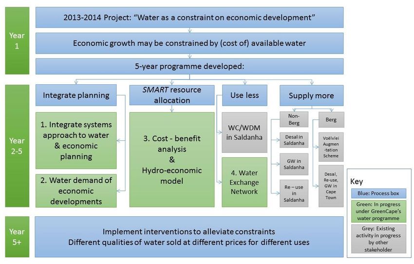
11 Appendix 3 Stakeholder & Initiatives mapping ......................................................................................... 89
11.1 Initiatives mapping ............................................................................................................................. 89
11.2 Workshop Report ............................................................................................................................... 91
12 Appendix 4 Water Demand of Saldanha Industrial Developments........................................................... 92
Figures
Figure 1-1 Location map and details of Saldanha 7
Figure 1-2 Programme activities1 10
Figure 2-1 Dams and major pipelines of the WCWSS 13
Figure 2-2 Industrial and residential water consumption (2012-2013) for main towns in SBM, from Withoogte
scheme 18
Figure 2-3 Map showing Withoogte Water Supply Scheme Infrastructure (data from GLS Consulting, and WCDM)
20
Figure 2-4 Map of Berg showing schematic representation of current water availability, allocation and use in the
Berg, and Saldanha Bay 21
Figure 2-5 Projected water demand of the Withoogte scheme compared to current allocation and planned
desalination plant. 28
Figure 2-6 Projected water demand of the Withoogte scheme compared to current abstraction and planned
desalination plant. 28
Figure 2-7 Projected water demand of the Withoogte scheme compared to current allocation and planned
additional use from the Berg. 29
Figure 3-1 Model for integrated water and economic development planning 35
Figure 3-2 Schematic diagram of the IDP methodology process (from DWAF, 2007c) 37
Figure 4-1 Withoogte Scheme Water Demand trajectories based on all potential developments 41
Figure 4-2 Withoogte Scheme Water Demand trajectories excluding unlikely development 42
Figure 4-3 Withoogte Scheme Water Demand trajectories excluding unlikely development, shown with
enhanced groundwater supply 43
Figure 5-1 Water accounting framework (UN 2005). 47
Figure 5-2 Diagram showing stocks and flows of water through the natural and economic system 48
Figure 10-1 Annual Rainfall Distribution in Berg WMA (data from WR2005) 73
Figure 10-2 Mean Annual Runoff Distribution in Berg WMA (data from WR2005) 74
Figure 10-3 Groundwater Recharge Distribution in Berg WMA (data from GRAII) 75
Figure 10-4 Groundwater Quality (EC) in Berg WMA (data from GRAII) 76
Figure 10-5 Potential sources of water pollution in Berg WMA (data from Department of Human Settlements, and
WARMS discharge permits) 77
Figure 10-6 All registered abstractions in Berg WMA, showing the registered abstraction resource (data processed
from WARMS) 79
Figure 10-7 All registered abstractions in Berg WMA, showing the registered user (data processed from WARMS)
80
Figure 10-8 Sum of registered abstractions per quaternary catchment in Berg WMA, and location of largest 15
water users (data processed from WARMS) 81
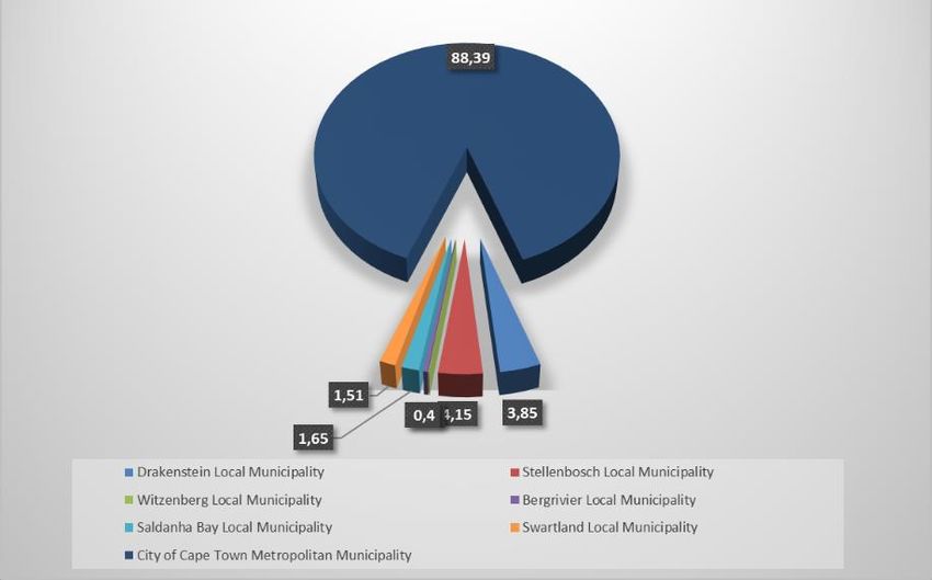
Figure 10-9 Contribution per LM (%) to the GDP in the Berg WMA (using data from PGWC, 2013c) 82
Figure 10-10 GDP contribution per economic sector, per LM within the Berg WMA (using data from PGWC,
2013c) 82
Figure 10-11 Green Water Footprint of Primary Sector across the Berg 83
Figure 10-12 Blue Water Footprint of Primary Sector across the Berg !Unexpected End of Formula
Figure 10-13 Economic productivity (as Jobs / m3 water) of the primary sector across the Berg 85
Figure 10-14 Economic productivity (as GDP / m3 water) of the primary sector across the Berg 86
Figure 10-15 Economic productivity (as Jobs / m3 water) of the tertiary sector across the Berg 87
Figure 10-16 Economic productivity (as GDP / m3 water) of the tertiary sector across the Berg 88
Tables
Table 2-1 Dams of the WCWSS (combined from DWS 2014a, and DWAF 2004b) .................................................... 12
Table 2-2 Current allocation and recent use from the WCWSS (million m 3/a) (from DWS, 2014a).......................... 14
WATER AS A CONSTRAINT ON ECONOMIC DEVELOPMENT: 2014-2015 REPORT 2
Table 2-3 Total (Surface) Water Requirements in the Berg WMA (million m 3/a) (DWAF, 2004b) ........................... 14
Table 2-4 Allocation (million m3/a), recent use (million m3/a), and growth rates for the WCDM schemes (data from
     DWS, 2014a) ...................................................................................................................................................... 16
Table 2-5 Towns served by the Withoogte bulk scheme (DWS, 2014a) ................................................................... 16
Table 2-6 Water use in Saldanha Bay for 2012-2013, based on SBMs billings (SBM, 2014) ..................................... 17
Table 2-7 Main water resources intervention options for the WCWSS (planning scenario in DWS 2014a) ............. 26
Table 2-8 Perspectives of the GreenCape water project, gained in informal stakeholder liaison ............................ 30
Table 3-1 Phases and outputs of the IDP development (from DWAF, 2007c) .......................................................... 37
Table 5-1:   Table showing comparison of water use classes to industrial statistics classes ................................... 49
Table 5-2 Economic productivity of various water use sectors (from DWAF, 2010a) .............................................. 50
Table 6-1 Summary review of previous Water Resources Planning Studies for Saldanha Bay Area ........................ 54
Table 9-1 Data Inventory ........................................................................................................................................ 68
Table 11-1    Summary of similar initiatives and projects........................................................................................ 89
Table 12-1   List of Saldanha Bay developments incorporated into water demand projection ............................... 92

Boxes
Box 2-1          Water roles and responsibilities between Saldanha Bay LM and WCDM ............................................... 19
Box 2-2          Chloride levels in the Withoogte Water Supply System .......................................................................... 22

WATER AS A CONSTRAINT ON ECONOMIC DEVELOPMENT: 2014-2015 REPORT                                                                                                     3
Acronyms
CBA                       Cost – benefit analysis
CCT                       City of Cape Town
BRIP                      Berg River Improvement Plan
DM                        District Municipality
DED&T                     Department of Economic Development & Tourism (PGWC)
DWA                       Department of Water Affairs
DWAF                      Department of Water Affairs and Forestry
DWS                       Department of Water and Sanitation
EAS                       Elandsfontein Aquifer System
GDP                       Gross domestic product
HEM                       Hydro-economic model
IDP                       Integrated development plan
IDZ                       Industrial Development Zone
LM                        Local Municipality
LRAS                      Langebaan Road Aquifer System
m3/a                      cubic metres per year (water flow volume, 1 cubic metre = 1000 litres)
Mm3/a                     million cubic metres per year
MAR                       mean annual runoff
n/s                       not supplied
NDP                       National Development Plan
PERO                      Provincial Economic Review and Outlook
PGWC                      Provincial Government of the Western Cape
RBIG                      Regional Bulk Infrastructure Grant
SIC                       Standard Industrial Code
SBM                       Saldanha Bay Local Municipality
TCTA                      Trans-Caledon Tunnel Authority
URV                       Unit Reference Value
WARMS                     Water Authorisation Registration Management System
WCDM                      West Coast District Municipality
WC/WDM                    Water Conservation and Demand Management
WCWSS                     Western Cape Water Supply System
WEN                       Water Exchange Network
WMA                       Water Management Area
WRC                       Water Research Commission
WWTW                      Waste water treatment works
WSA                       Water Services Authority
WSP                       Water Services Provider

WATER AS A CONSTRAINT ON ECONOMIC DEVELOPMENT: 2014-2015 REPORT                                    4
Report Status
 Report Title                               Water As a Constraint on Economic Development: 2014-2015
                                            Research Project Progress Report
 Author(s)                                  Helen Seyler, Chris Millson
 Reviewer(s)                                Lauren Basson
 Status                                     Final Draft
 This report should be referenced as:       GreenCape, 2015. Water As a Constraint on Economic
                                            Development: 2014-2015 Research Project Progress Report.
                                            Compiled by H. Seyler, and C. Millson.

WATER AS A CONSTRAINT ON ECONOMIC DEVELOPMENT: 2014-2015 REPORT                                   5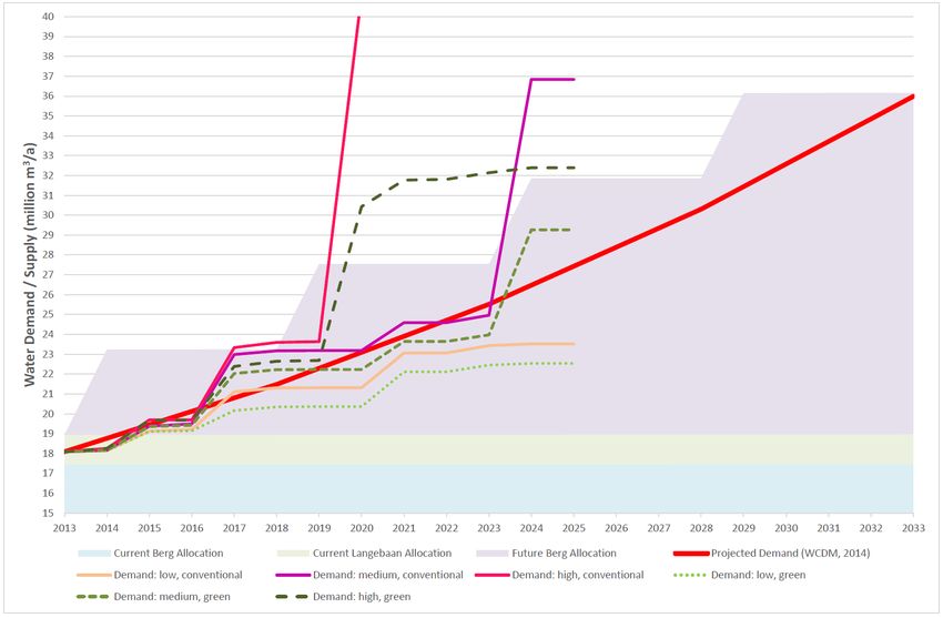
1     Background

1.1    Project initiation
GreenCape is a Special Purpose Vehicle established by South Africa’s Western Cape Government with the
mandate to support the development of the Green Economy in the Western Cape. Under this mandate
GreenCape operates ‘sector desks’ and undertakes research projects to provide strategic support to various
sectors key in the development of a green economy.

The project “Water as a Constraint on Economic Development” commenced in 2013, and received initial
funding from the Provincial Department of Economic Development and Tourism (DED&T), for the financial
years 2013-2014 and 2014-2015.

The motivation for project establishment was the acknowledgement that the Western Cape is a water-
stressed region, and that in order to plan for economic growth, an understanding of how much water is used
by the region’s economy, and where and how it is used, is required. A particular interest area for the
establishment of the project was water requirements and availability for proposed development in Saldanha
Bay, and whether and how water pricing could be a mechanism to realise water efficiency. It was recognised
that work should commence in a phased approach in order to develop an understanding of water
consumption across the economy, and how this consumption is linked to measures of economic productivity.
It was also recognized that this understanding would facilitate the identification of critical constraints, and
hence the design and ultimate implementation of interventions to alleviate these. Potential constraints
include the impacts of water availability and water quality on industry, as well as the industry impacts (in
terms of reducing both water availability and quality) on water resources.

Work to date (having successfully completed the first two years of a five year programme) has laid the
foundation for further detailed work in this area, to be completed over the next three years. Broadly speaking,
the project’s aim is to support decision-makers in the field of water resources planning at local and provincial
government level, as well as the current and proposed future industry in Saldanha Bay.

WATER AS A CONSTRAINT ON ECONOMIC DEVELOPMENT: 2014-2015 REPORT                                             6

Location: The project focusses on Saldanha
                                                                  Bay, located on the West Coast of South Africa,
                                                                  140 km north of Cape Town.

                                                                  Water setting: Saldanha is a coastal town
                                                                  within the Berg Catchment. The Berg River is a
                                                                  heavily utilised system with major transfers
                                                                  into it from the neighbouring Breede River
                                                                  Catchment, and transfers out of it to supply
                                                                  settlements west of the actual river catchment
                                                                  (such as Cape Town). The river is managed over
                                                                  an area similar to that which is serves, an area
                  WMA                                             termed the Berg Water Management Area.

                                                                  Political Setting: Saldanha Bay town is within
                                                                  Saldanha Bay Local municipality, within the
                                                                  West Coast District Municipality, in the
                                                                  Western Cape Province of South Africa.

Figure 1-1       Location map and details of Saldanha

WATER AS A CONSTRAINT ON ECONOMIC DEVELOPMENT: 2014-2015 REPORT                                                      7
1.2 Programme Overview
The following key questions broadly shaped an initial scoping assessment of existing work in water resources
and economic development in Saldanha Bay, and the wider Berg River Catchment:
1. How much water is used by the region’s economy; where and how is it used?
2. How does consumption compare to economic productivity within the main economic sectors and of
the largest water users?
3. Which economic activities pose the greatest threats to water resource availability (water quantity
and water quality), and in turn to sustainable economic development?
4. In what ways could water resource availability constrain the sustainable economic development of
the Berg Catchment?
5. What interventions (including potential water pricing mechanisms) would best enable continued
sustainable economic activity, whilst being cognisant of other areas of importance/objectives in these
areas?
The key outcome of initial scoping highlighted that economic growth (in Saldanha Bay) may be constrained
by (the cost of) available water. A five-year “Water as a constraint on Development” programme was thus
developed, informed by insights revealed in the scoping exercise (GreenCape, 2013).
The overarching aim of the 5 year programme is to contribute to strategic decision-making for economic
development, through answering “What are the ‘right’ sources of water, at what quality, for the ‘right’
developments, for the ‘right’ price?” This question proposes a vision of a new economy in which different
sources and qualities of water are sold at different prices, to different users, for different uses. Although the
investigation is rooted in Saldanha Bay, the question reflected in the overarching aim is also applicable to
economic development in other water-constrained areas. To address the overarching aim and vision, the
programme will:
develop an approach for integrating economic development and water resources planning to
promote coordinated infrastructure development; and
develop decision-support-systems or tools to support strategic decision-making for water resources
and economic development planning.
The programme therefore intends to contribute solutions to current development challenges for Saldanha
Bay, thus supporting decision-makers at local, provincial and national government, and enabling industry
development in Saldanha Bay. In turn the tools developed in this process can be applied in other water-
constrained catchments.
1.3 Programme Structure and Activities
Potential solutions to alleviate the constraint posed on economic development by water availability were
defined during the scoping assessment. These solutions are shown in Figure 1-2, which also summarises the
programme development and includes reference to relevant work carried out by other stakeholders. The
project’s scoping phase (start of Year 1) included “initiatives mapping” and a “gap analysis” to focus efforts
going forward.
A key outcome of the scoping phase was the indication that economic growth might become constrained by
the cost of available water. Furthermore, this initial exploratory work highlighted limitations in existing
planning processes, which themselves could act as a barrier due to poor integration of water resources and
economic development planning. Alleviating constraints to development therefore requires an integrated,
systems approach. This approach will need to recognise the interdependent nature of water resources and
economic development (item 1 in Figure 1-2). This is described in Section 32.7. As a first step in implementing
the required systems approach to economic development and water resources planning, development
WATER AS A CONSTRAINT ON ECONOMIC DEVELOPMENT: 2014-2015 REPORT 8proposals were collated and their water demands estimated in order to determine implications for development planning and infrastructure (item 2 in Figure 1-2). This is described in Section 4. Managers of water-constrained catchments should ensure that the currently available resources are allocated for optimal benefit including economic development and job creation (“SMART allocation”). For example, this may include allocating water preferentially to a proposed industry based on the fact that it will create significant employment opportunity. During 2014-2015, potential approaches to this type of allocation were considered, laying the foundation for the potential of a cost-benefit approach to be assessed in the next phase of work (item 3 in Figure 1-2). This is described in section 5. However, taking a systems approach (as described above) means that the costs/ benefits of one development or resource supply intervention should be viewed in a broader context. This includes understanding the trade-offs and knock on effects of decisions made on a catchment level. A “Hydro-Economic Model” (HEM) will be developed in future project phases for this purpose. Decision makers will therefore benefit from being able to access a database support system, which spatially portrays the likely impacts of actions taken within various scenarios. In response to a water availability constraint, one of the first solutions to consider would be to reduce demand through improving water efficiency. Water conservation and demand management (WC/WDM) is under investigation by Saldanha Bay Local Municipality (SBM), and is overseen by the Department of Water and Sanitation (DWS). In addition to traditional WC/WDM measures, a “Water Exchange Network” (WEN) has been considered, in which waters of different qualities are cascaded (used and passed on) between major industrial users. A preliminary investigation into the potential for a WEN in Saldanha Bay was completed during Year 2 of the project (2014-2015), and suggests that a pre-feasibility study is warranted (item 4 in Figure 1-2). This work is described in Section 6. Beyond the successful reduction of demand through implementation of water efficiency measures, another solution would be to increase supply via often capital intensive infrastructure developments. Saldanha Bay could receive additional water from the Berg River, through various schemes that intend to make more water available to the Berg River’s supply system (the Western Cape Water Supply System, or WCWSS). Alternatively, Saldanha Bay could generate local water supply from desalination, groundwater use, or traditional water re-use. These options are currently under investigation by the relevant responsible authorities: City of Cape Town (CCT), SBM, and West Coast District Municipality (WCDM), overseen by the DWS. WATER AS A CONSTRAINT ON ECONOMIC DEVELOPMENT: 2014-2015 REPORT 9
Figure 1-2        Programme activities1
1
Acronyms applied only in Figure 1-2: Desal = desalination, GW = groundwater

1.4     Structure and purpose of this report
This report documents results of programme activities carried out in 2014-2015. Summarised results from
the scoping exercise (2013-2014) were documented in a report targeted at the project funders (GreenCape,
2013). The relevant findings from the scoping exercise, including the motivation for the development of a 5-
year programme, and the development of the solutions to be investigated under this programme (Figure 1-2),
are reincorporated in Section 2 of this report, such that it can be read as a standalone document.

Section 2 (and its appendices) documents the status quo of water resources and economic development in
Saldanha and the wider Berg region, incorporating key findings and key insights of the scoping phase. The
information provided in the report is linked to what is relevant for the programme, and is not intended to
provide a comprehensive description of water and economic situation in Saldanha Bay and the Berg WMA.
Furthermore, the information is based on a combination of published reports and information and
perspectives collated from discussions and interviews. Given the information is a mix of factual, anecdotal
and perspective-based, GreenCape does not take responsibility for any factual errors.

The remaining sections document results of the programme activities listed in Section 1.3. The final section
collates findings to date, and outlines the necessary activities for the remainder of the programme.

    Italic green text boxes are used throughout the text to document: i) questions that arise from the presented
    material that warrant further investigation in future phases of the programme or ii) actions recommended
    to GreenCape, to be included in future programme phases

WATER AS A CONSTRAINT ON ECONOMIC DEVELOPMENT: 2014-2015 REPORT                                               10
1.5 Alignment to Existing Policies and Strategies
GreenCape’s project is aligned to both national and provincial visions for economic development. Key
national documents include the National Development Plan (NDP) and the Green Economy Accord. The NDP
refers to the primary challenges for development, which include the fact that “the economy is unsustainably
resource intensive” (National Planning Commission, 2011). One of the objectives of the NDP is to ensure that
there is enough water for agriculture and industry despite the fact that the country is water scarce. The NDP
also recognizes that this scarcity will result in trade-offs in the use of water.
The Green Economy Accord (Department of Economic Development, 2011) documents the commitments of
the government to support, promote, and plan for developments in green technology. A green economy can
broadly be defined as an economy that “promotes growth while reducing pollution and greenhouse gas
emissions, minimizing waste and inefficient use of natural resources, maintaining biodiversity and
strengthening energy security” (WRC, 2013a). Growing awareness of water scarcity has meant that the need
to address inefficient water use is a priority. This project will assess water use compared to GDP contribution
(water productivity as GDP per drop1), to highlight water- inefficient industries, in order to inform water
‘smart’ economic development decisions to be taken.
On a provincial level, the Western Cape government outlines five Provincial Strategic Goals (PSGs, replacing
the Provincial Strategic Objectives). GreenCape’s project is aligned to PSG1 (creating opportunities for growth
and jobs), PSG4 (enabling a resilient, sustainable, quality and inclusive living environment), and PSG5
(improving governance and service delivery through partnerships).
The Western Cape aims to become the “leading green economic hub on the African continent. The “Green is
Smart: Green Economy Strategy Framework” (PGWC, 2013a) sets out how this aim can be achieved, including
goals, roles and responsibilities. The framework document acknowledges that the Western Cape is
particularly vulnerable to climate change impacts. The document highlights a number of approaches, such as
improving water efficiency in agriculture and industry. In addition, the document highlights enablers to unlock
economic opportunities, such as WC/WDM, development of groundwater resources, reuse of effluent,
desalination, and expanded and diversified agriculture. Water pricing is also highlighted as an enabler. In
relation to water, the framework document states “it is proposed that the Western Cape public sector review
the pricing of all resources, including water… to help identify where it may be able to introduce incentives
and disincentives to promote behaviour change to a low-carbon economy”. In addition, “Ensuring energy and
water efficiency through incentives and pricing” is listed as a responsibility of local municipalities.
The project also aligns with PGWC’s Provincial Economic Review and Outlook (PERO), which recognises that
the availability of water resources may constrain development (PGWC, 2013b). Also, the Western Cape
Sectoral Economic Prospects (DED&T 2011) recognizes the potential constraint of water availability.
In addition to the above, the project is also well aligned with the province’s Ministry of Economic
Opportunities’ Project Khulisa report, which identifies water as a key enabler of economic growth (PGWC,
2014). This study highlights that water can act as a constraint on the development of the oil and gas industry
(which is identified as one of the key game changer industries), specifically in Saldanha Bay’s Industrial
Development Zone (IDZ). Likewise, the agri-processing sector (another priority sector) will not be enabled
without the availability of water.
1
http://data.worldbank.org/indicator/ER.GDP.FWTL.M3.KD
WATER AS A CONSTRAINT ON ECONOMIC DEVELOPMENT: 2014-2015 REPORT 112 Status Quo
2.1 Water Availability and Use in the Berg WMA
The Department of Water and Sanitation (DWS) previously divided the country into 19 Water Management
Areas (WMAs), each containing a large river system (DWAF, 2004a). The Berg River catchment supplies areas
outside of its natural boundaries (Cape Town for example), and the boundary of the Berg WMA includes the
supply area, and several smaller catchments (Figure 1-1). With the second revision of the National Water
Resources Strategy (DWA, 2013) 19 WMAs were reduced to 9, through an amalgamation of areas. As such
the Berg no longer constitutes an individual WMA, but is still referred to as such in this report.
Surface water availability is discussed in two key quantities: the first is the mean annual runoff (MAR) per
catchment, which is a sum of all flow in rivers within that catchment. This MAR is either reported as “present
day”, which is significantly altered by factors that intercept flow (including alien vegetation, rain-fed crops,
run-of-river’ abstraction), or as ‘naturalised’ MAR which is an estimate of pre-development MAR based on
the hydrology of a catchment. Not all MAR is available for use by the economy, given that a portion must
remain within the river system to sustain environmental flows (the Reserve). Also, it would not be possible
to capture all MAR. Surface water is impounded in dams, the yield of which is a function of the dam’s capacity
and the MAR, and the user-defined assurance of supply.
The Berg River is a heavily utilised system. Through a set of five major dams (listed in Table 2-1), the Berg
River supplies water to the majority of municipal demands (both domestic and industrial) as well as significant
agricultural demands across the Berg WMA. The structure of the supply network, collectively termed the
Western Cape Water Supply System (WCWSS, Figure 2-1), enables these dams to be operated in an integrated
manner, maximizing efficiency. One of the dams (Theewaterskloof) is located in the neighbouring Breede
River catchment, and contributes water to the Berg Catchment and the WCWSS via an inter-basin transfer.
The DWS (2014a) point out that the total integrated system yield (at a 98% level of supply assurance for all
user categories) is 596 million m3/a. This figure is deduced from the maximum annual water requirements
that the system can supply, before the risk of curtailments become too great.
Table 2-1 Dams of the WCWSS (combined from DWS 2014a, and DWAF 2004b)
Dam Capacity (million m3) Yield (million m3/a) Owner User
Theewaterskloof 432 219
Voëlvlei 158 105 DWS CCT / WCDM /
Irrigators
Wemmershoek 58 54 CCT CCT / Drakenstein
Upper Steenbras 30 40 CCT CCT
Lower Steenbras 34
Berg River Dam 127 80 TCTA (DWS) CCT / Others /
Irrigators / Overberg
Palmiet 23 DWS / Eskom CCT/ Eskom
Compensation 38
Additional yield from integration 11
Total (firm yield derived from legacy hydrology and using the 570
Water Resources Yield Model)
Total integrated system yield (stochastic yield derived using 596
the Water Resources Planning Model)
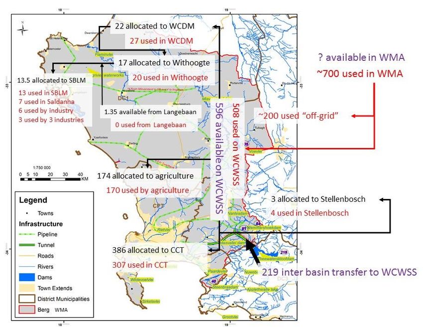
WATER AS A CONSTRAINT ON ECONOMIC DEVELOPMENT: 2014-2015 REPORT 12The Berg River originates in the
mountainous areas to the
southeast of the map. It flows
north, collecting various
tributaries along its course,
turning northwest to discharge
into the ocean. The dams of the
WCWSS are all in the upper
mountainous reaches of the
river or its tributaries.
Saldanha Bay is in the lower
reaches of the catchment and
supply system.
Figure 2-1 Dams and major pipelines of the WCWSS
The WCWSS supplies raw water to domestic & industrial users (via municipal supply), and to agricultural users
(via Water User Associations and irrigation boards). The major domestic & industrial user is the City of Cape
Town, which then supplies to users within the Metropolitan area. The West Coast District Municipality also
receives water from the WCWSS and operates smaller schemes to supply West Coast towns and industry, as
does the Stellenbosch Local Municipality. The current allocations and recent use from the system are shown
in Table 2-2 below. As total allocations were greater than (previous estimates of) total yield (DWAF 2004a)
and in response to strain on the system, water use by the agricultural sector has been ‘çapped’, and no
increase in water use by the sector is permitted. The total consumption from the WCWSS has reduced in the
last 3 years due to efforts mostly by the City of Cape Town to curb water losses, and decrease domestic water
demand (DWS,2014a).
Comparing water allocations to estimates of recent use shows that there is approximately 60 –
86 million m3/a of un-used water in the WCWSS, with most of this allocated to the City of Cape Town.
However, budgeting for the ecological reserve is not fully implemented (releases are currently only
accommodated from Berg River Dam, and no other dams on the WCWSS). Once fully implemented, specified
water volumes required to sustain ecological health will be released from all dams, thus reducing the total
system yield (DWS, 2014).
Depending on the estimate of total yield used, the system is currently somewhere between being over-
allocated by 14 million m3/a, and under-allocated (i.e. an available amount) of 12 million m3/a. This is likely
the cause for the commonly held perception that the Berg is a “fully allocated system”, in which any growth
in water demand would need to come from other water sources.
WATER AS A CONSTRAINT ON ECONOMIC DEVELOPMENT: 2014-2015 REPORT 13Table 2-2 Current allocation and recent use from the WCWSS (million m 3/a) (from DWS, 2014a)
User Allocation 2012/2013 Use 2013/2014 Use
City of Cape Town 385.90 312.92 306.77
West Coast District Municipality 21.64 25.29 26.86
Stellenbosch LM 3.00 3.00 4.01
Agriculture 173.60 169.00 170.00
Total allocation / use 584.14 510.21 507.65
Total (firm yield derived from legacy hydrology) 570
Total integrated system yield (stochastic yield) 596
Note: years are hydrological years, October to September
In addition to the Berg’s system yield from these dams, private “off-grid” abstractions also utilise the Berg
River (or tributaries within its catchment) mostly for agriculture. Significant aquifers also exist within the Berg
WMA. Total (surface) water requirements in the Berg WMA per sector add up to just over 700 m3/ as shown
in Table 2-3 below. In the year 2000 the “on grid” demand on the WCWSS (which includes domestic supply
and irrigators), was around 500 million m3/a, implying that “off-grid” demand in 2000 was 200 million m3/a.
Although this old data, it provides an estimate of the total (surface) water demand (use) in the Berg WMA,
(i.e. that supplied by the WCWSS, and private “off grid” abstractions).
Table 2-3 Total (Surface) Water Requirements in the Berg WMA (million m3/a) (DWAF, 2004b)
Water Use Sector Water Requirement in 2000
(million m3/a)
Irrigation 301
Urban 389
Rural 14
Afforestation 0
Total 704
Analysis of various datasets, including the water use registrations held within the DWS’s Water Authorisiation
Registration Management System database (WARMS) was undertaken to determine (1) where and how the
~700 million m3/a of surface water is used across the Berg, (2) how much groundwater is available and used,
and (3) the economic benefit of water used. An inventory of datasets used for the status quo assessment is
listed in Appendix 1 (Section 9), and key data and summary insights of the water use and availability
assessment are presented in Appendix 2 (Section 10).
WATER AS A CONSTRAINT ON ECONOMIC DEVELOPMENT: 2014-2015 REPORT 14Given that the WMA appears to be operating close to
capacity (or at least close to the allocated capacity), At the moment these WRYM and WRPM
development planning needs to carefully consider the total are operated and updated by specialized
amount of water available. This would be the total amount consultants for DWS. Would it be feasible
of water available to avoid reaching an environmental limit to develop a spatially accurate
defined by the responsible authority, and which is available hydraulically linked surface and
within the WCWSS dams (including that received via inter- groundwater model for the WMA, which
basin transfer, plus that available for “off-grid” abstractions incorporates the system model, with a
from surface water and groundwater). This seemingly simple simplified Decision Support System front-
number is not readily accessible in current literature. A end to enable development planners to
further complication is that the hydrology models used to access this information? Water allocation
manage the WCWSS (the Water Resources Yield Model, the in the UK is managed with this type of
Water Resources Planning Model and the Systems Model) model, the DSS is able to determine the
do not replicate the physical catchment or the “off-grid” impact of a proposed abstraction, with few
surface or groundwater availability – but focus only on the more complex cases being referred to
system yield from dams. There is currently no integrated specialists.
catchment (surface and groundwater) or system model.
2.2 Water Availability and Use in Saldanha
The total allocation to the WCDM from the Berg River is 21.64 million m3/a (Table 2-2), 17.4 million m3/a of
which is allocated to the Withoogte scheme, the rest allocated to its Swartland regional scheme (Table 2-4,
referred to as “Misverstand Bulk scheme” and Voëlvlei Bulk scheme respectively in Figure 2-3).
For the Withoogte scheme, raw water is abstracted directly from the Berg River at Misverstand reservoir and
pumped to a relatively small off-channel storage reservoir at the Withoogte water treatment plant. The
reservoir is located about 17 km to the West of Misverstand at a higher altitude of 175m above sea level.
From here the Withoogte’s potable water gravitates (mainly) towards the west for distribution mainly in the
Saldanha Bay LM and some surrounding areas (Table 2-5).
The abstraction from the Berg River at Misverstand comprises two flow components:
1) Flow in the river due to normal hydrological and geohydrological influences, or so-called "run of river"
flow. This component is around 20% of the supply.
2) Artificial river flow in addition to run of river, resulting from releases of water from Voëlvlei dam with
the purpose of abstraction for the WCDM at Misverstand reservoir. Although the releases of water
from Voëlvlei are intended for abstraction by the WCDM at Misverstand, an unknown volume of the
released water is "lost" due to various natural causes and illegal abstraction by farms along this
stretch of river. The losses are generally taken as 25% of the release volume (DWAF, 2007a). In turn,
Voëlvlei dam, an off channel storage dam, has several sources including diversion canals from the
Klein Berg and Vier en Twintig River, and also a diversion of winter flood waters in the Berg River.
What additional yield would be available to Withoogte (this 25% of release volume) if these losses were
overcome? By how many years does this delay future reconciliation interventions? How much of the 25%
loss is related to illegal abstraction v’s evaporation and other factors? And therefore do we invest in
curtailing illegal abstraction or in reducing evaporation in this stretch of river (by piping / covering the
water)? How does the cost of these interventions compare to other reconciliation options?
In addition to the allocation from the Berg, groundwater is pumped from a wellfield accessing the Langebaan
Road Aquifer and added to the Withoogte bulk supply system, with an allocation amount of 1.5 million m3/a
(Table 2-4).
WATER AS A CONSTRAINT ON ECONOMIC DEVELOPMENT: 2014-2015 REPORT 15The recent total water use from the system (Table 2-4) shows:
The total allocation for the WCDM from the WCWSS is 21.64 million m3/a but this has been exceeded
since at least 2008-09, by up to 5.2 million m3/a.
This overuse is contributed to by overuse within both the Withoogte and Swartland schemes. The
allocation for Withoogte from WCWSS is 17.44 million m3/a, which has been exceeded in the last
three years by up to 2.9 million m3/a.
Although Swartland exceeds the allocation from WCWSS, the water demand growth rate appears
stable and in slight decline. The water demand growth rate at Withoogte is around 5%, and this
increase in demand initially translated into an increase in groundwater use from the Langebaan
Aquifer (growth rates reached 52% in 2010-11), but has recently been met by increase in use of Berg
Water from WCWSS (growth rate of 9% in 2013-14). Groundwater use has declined since 2012. If
groundwater had been abstracted at the full allocation (1.35 million m3/a), total exceedances by the
WCDM from the WCWSS would reduce to a maximum 3.87 million m3/a. (Some comments on
increased groundwater use are provided in Section 6)
Table 2-2 shows that there is currently around 60 – 86 million m3/a of un-used water in the WCWSS.
This implies that there should be no concern over current water supply despite the exceedances. As
echoed by recent comments by DWS (DWS, 2014b), it is merely an issue of legal allocations.
Table 2-4 Allocation (million m3/a), recent use (million m3/a), and growth rates for the WCDM schemes (data
from DWS, 2014a)
Allocati
Scheme Component on 2008-09 2009-10 2010-11 2011-12 2012-13 2013-14
Withoogte from Misverstand 17.44 17.49 16.93 16.71 17.53 18.69 20.36
Withoogte from Langebaan 1.5
Aquifer (1.35) + 0.44 0.62 0.97 1.09 0.93 0.00
Swartland from Voëlvlei Dam 4.2 6.66 6.76 6.64 6.59 6.60 6.50
Total for Withoogte 18.79 17.92 17.55 17.68 18.61 19.62 20.36
Total for WCDM 22.99 24.59 24.32 24.31 25.21 26.22 26.86
Total from WC WSS 21.64 24.15 23.69 23.34 24.12 25.29 26.86
Scheme Growth Rate 2008-09 2009-10 2010-11 2011-12 2012-13 2013-14
Withoogte from Misverstand n/a n/a -3% -1% 5% 7% 9%
Withoogte from Langebaan
Aquifer n/a n/a 42% 56% 12% -14% -100%
Swartland from Voëlvlei Dam n/a n/a 2% -2% -1% 0% -1%
Total for Withoogte n/a n/a -2% 1% 5% 5% 4%
+
Groundwater abstraction is licensed for 1.5 million m3/a, however a recent recommendation was made that
this be reduced to 1.35 million m3/a
Table 2-5 Towns served by the Withoogte bulk scheme (DWS, 2014a)
Bulk System Local Municipality Towns
Withoogte Saldanha Bay Hopefield, Langebaan, Vredenberg, Saldanha, St Helena Bay
Swartland Koringberg, Morreesburg
Bergrivier Velddrif, Dwarskersbos
Of the ~18 – 20 million m3/a of water in the Withoogte scheme, approximately 13.5 million m3/a is sold from
the WCDM to the SBM for distribution (number based on billings, WCDM, 2014), the remainder being sold to
WATER AS A CONSTRAINT ON ECONOMIC DEVELOPMENT: 2014-2015 REPORT 16other LMs from the Withoogte (or comprising losses). Within Saldanha Bay LM, Saldanha town uses
6.75 million m3/a (52%), 89% of which is for industry (Table 2-6, Figure 2-2). Industry in Saldanha town is
therefore the most significant user of the Withoogte scheme.
Of the 6.775 million m3/a for industry in Saldanha, around 50% is allocated to three major industries, Arcelor-
Mittal, Tronox and Duferco, who have allocations of 2.4, 0.5, and 0.4 million m3/a respectively (information
sourced from industry directly).
The water use and availability information for the Berg WMA and Saldanha area is summarized in the
schematic graphic in Figure 2-4 below. The roles and responsibilities of the WCDM and SBM with regard to
water provision are summarised in Box 2-1.
Table 2-6 Water use in Saldanha Bay for 2012-2013, based on SBMs billings (SBM, 2014)
Total
(million Residential Industrial Farms
Town m3/a) Total (m3/a) (m3/a) (m3/a) (m3/a) Other (m3/a)
Saldanha 6.75 6,749,565 624,558 6,002,527 122,480
Vredenburg 2.15 2,153,437 1,058,192 107,407 9,973 977,865
St Helena
baai 1.09 1,094,379 532,142 516,633 15,255 30,349
Louwville 1.06 1,062,599 975,862 29,527 57,210
Langebaan 0.88 883,486 699,352 98,471 6,838 78,825
Rural 0.55 553,171 3,061 757 149,526 399,827
Hopefield 0.21 213,312 158,214 10,151 11,482 33,465
Long Acres 0.21 214,891 124,710 38,217 51,964 -
Total 12.92 12,924,840 +
4,176,092 6,803,690 245,038 1,700,021
+ 3
It is assumed that the difference between what is sold to the SBM (13.5 million m /a) and what is sold by the
SBM (12.9 million m3/a) reflects un-accounted for water (losses).
WATER AS A CONSTRAINT ON ECONOMIC DEVELOPMENT: 2014-2015 REPORT 17Figure 2-2 Industrial and residential water consumption (2012-2013) for main towns in SBM, from Withoogte scheme WATER AS A CONSTRAINT ON ECONOMIC DEVELOPMENT: 2014-2015 REPORT 18
Roles and Responsibilities for Water provision in Saldanha Bay

 In the Western Cape, Local Municipalities have the mandated function of Water Services Authorities (WSA)
 and Water Services Providers (WSP). Saldanha Bay Local Municipality (SBM) acts as the Water Services
 Authority, but given the regional nature of the supply source, the function of the Water Services Provider
 has been delegated to the West Coast District Municipality (WCDM).

 As the WSA, the Saldanha Bay LM is responsible for providing water services to all people under its
 jurisdiction, while the WCDM as the WSP is responsible for the bulk water services. In practice this means
 the WCDM is responsible for physical provision of water (maintenance of infrastructure), and SBM is
 responsible for ensuring sufficient water is available to for use in this infrastructure (water resources
 planning, future reconciliation, capital investment for infrastructure to bring new water resources online).
 The DWS as the custodian of national water resources, is responsible for oversight on these activities, and
 for licensing all uses of water resources (i.e. abstraction, discharge to a water course etc).

 The WCDM has previously been acting as a WSA, undertaking future water resources planning for the
 Withoogte and other schemes that it operates, yet it has recently been confirmed that it should act solely
 as a WSP, with the local municipalities retaining WSA status (pers comm Nik Faasen).

 For Saldanha this means that local water resource interventions to meet future supply (i.e. additional
 groundwater use or desalination) falls in the responsibility of SBM. Maintenance of infrastructure to meet
 future demand (i.e. upgrading the pipeline from Misverstand to the LM to cater for greater demand), falls
 in the responsibility of WCDM.
                                             How does revenue collection from water sales function
                                             between the LM and DM? How do these roles and
                                             responsibilities impact on development planning? How does
                                             the governance structure support or impede a fully integrated
                                             approach to economic and water resource planning?

Box 2-1          Water roles and responsibilities between Saldanha Bay LM and WCDM

WATER AS A CONSTRAINT ON ECONOMIC DEVELOPMENT: 2014-2015 REPORT                                           19
Figure 2-3 Map showing Withoogte Water Supply Scheme Infrastructure (data from GLS Consulting, and WCDM) WATER AS A CONSTRAINT ON ECONOMIC DEVELOPMENT: 2014-2015 REPORT 20
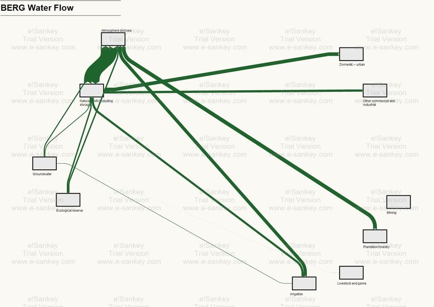
Figure 2-4       Map of Berg showing schematic representation of current water availability, allocation and use in the Berg, and Saldanha Bay

WATER AS A CONSTRAINT ON ECONOMIC DEVELOPMENT: 2014-2015 REPORT                                                21
2.3 Berg River Water Quality
2.3.1 Chloride concentration
Water quality of the Berg River deteriorates in a downstream direction due to natural geological influences
and as a result of human activities, such as agricultural activities (river modifications, water abstractions, and
runoff from irrigated soils), urban storm water, discharge from wastewater treatment works (WWTW), and
runoff from informal settlements. Water quality is the collective term for the chemical, physical, and
biological characteristics the water, and each of these characteristics is impacted differently by a particular
activity or pollution source. For example, informal settlements generally contribute micro-biological pollution
to water courses whereas the agricultural sector contributes a high nutrient load to water courses causing
eutrophication, and agricultural land practices enhance salinisation.
The town of Saldanha Bay, as a user of the Berg River from its lower reaches, is heavily influenced by upstream
activities. Although bacteriological contamination may be the most significant water quality risk for the
agricultural sector, this can be treated by chlorination in the Withoogte system before reticulation to
Saldanha Bay and is not a significant threat to the water users in Saldanha. High salinity levels in the received
water do however pose a problem to the steel processing industry. Water with up to 650 mg/l has been
supplied, compared to a required concentration of less than 100 mg/l (See Box 2-2), and pre-treatment is
required. Water with higher salinity can be re-used fewer times in processing, increasing total consumption
of potable water as well as increasing in the amount of treatment chemicals used (Duferco, 2014). The high
salinity therefore impacts industrial operating costs and also impacts on production. Industry has called for
action from the responsible authorities to curb the increasing salinities (Duferco, 2014).
Chlorides in the Withoogte Water Supply System
The concentration of chloride has been measured in the incoming water at Duferco Steel Processing plant
since before 2004 and shows strong seasonal fluctuation (Duferco, 2014):
Summer levels are stable and return to below 100mg/l reaching a minimum of around 50mg/l
Chloride levels peak in winter (approximately in August) with slow subsequent decline. Prior to
2006 all chrloride levels were below 200mg/l.
The magnitude of the winter peaks show a rising trend from winter 2006 to winter 2011, with
winter maximum levels rising consistently by ~50mg/l per year, from 400 mg/l in 2006, to
650 mg/l in 2011. Winter 2012 and winter 2013 peaks broke this tend yet remain high (250 mg/l
and 400 mg/l respectively)
The chloride data shows a noisy signal with several lower-magnitude peaks (50 to 100 mg/l above
Box 2-2 Chloride
currentlevels in the Withoogte
background) Water
throughout theSupply
year.System
2.3.2 ‘Quick fixes’ to alleviate constraint on industry
Data for incoming and outgoing water quality at the Misverstand dam show that chloride contents are similar,
and that sediment removal methods could not be contributing to the chloride level (pers. comm. Nik Faasen,
16 October 2014). Measures to lower salinity in the water at Misverstand dam are not financially viable for
the WCDM, and hence the chloride content is minimised by reducing raw abstraction if incoming chloride
spikes are noted. No raw water treatment ‘quick fixes’ are available to lower the salinity of the water that
industries receive from the Withoogte Water Supply System. The West Coast District Municipality believe
that the salinity problem can only be tackled via collaboration and coordination between all water users along
the length of the Berg River (pers. comm. Nik Faasen, 16 October 2014).
WATER AS A CONSTRAINT ON ECONOMIC DEVELOPMENT: 2014-2015 REPORT 22You can also read