Hillcrest Heights (76A-044)
←
→
Page content transcription
If your browser does not render page correctly, please read the page content below
Hillcrest Heights (76A-044)
Hillcrest Heights is a mid-twentieth-century residential suburb in Prince George’s County. The
community is located just south of the southeastern boundary of Washington, D.C. and Prince George’s
County. The community of Marlow Heights is located to the south. Branch Avenue, a heavily traveled
road, runs to the east of the neighborhood.

Prior to the platting of the first subdivision, the land that would become Hillcrest Heights was
undeveloped and heavily wooded. The land was originally part of the eighteenth-century plantation
known as Colebrooke, which was owned by the Addison family.1 Prince George’s County land records
document that one of the earliest subdivisions in the area appears to be Section One of Good Hope Hills,
which was platted in 1926 at the present-day juncture of Southern Avenue and Naylor Road.2 However,
the 1938 aerial image of the area shows no development, only farmland and wooded areas. Despite the
lack of suburban development, which was commonplace in western Prince George’s County in the first
half of the twentieth century, Section One of Colebrooke was platted just east of Branch Avenue in 1940.3
Many of the elements of the subdivision design reflected the planning guidelines and standards promoted
by the Federal Housing Administration (FHA), such as the curvilinear plan, long uninterrupted blocks,
proximity to public transportation, and adaptation of the design to the topography of the land. Adhering to
the same planning principles, the Colebrook Development Corporation platted Section Two of
Colebrooke one year later in 1941.4 Several other small subdivisions were platted during World War II
(1941-1945), but none of the lots were improved despite the burgeoning population that was prompting
suburban development in many of the counties surrounding Washington, D.C.

Large-scale development in Hillcrest Heights began in earnest after World War II. Returning veterans and
increasing numbers of federal workers poured into the area and needed affordable, safe, attractive, and
well-planned communities. Anthony Carozza and his wife Anna Louise had amassed nearly 800 acres of
land east of old Naylor Road in the early 1940s.5 After the war, in 1946, Carozza platted Hillcrest
Heights, which was named for the nearby Hillcrest neighborhood of Washington, D.C. Lots ranged in
size, but averaged approximately 6,000 square feet.6 Because of Prince George’s County building
restrictions, septic systems were prohibited on lots of less than 10,000 square feet, forcing Carozza to
finance installation of a large portion of the water and sewer lines for the community.7

Prompted by Carozza’s success, other developers began to move into Hillcrest Heights to take advantage
of the affordable land. In the late 1940s and 1950s, Paul P. Stone, a Washington, D.C. real estate
developer, began platting additional sections to Hillcrest Heights.8 Stone planned a 300-house
development of “all-brick ramblers.” Buyers could choose from nine different plans, with prices
beginning at $12,750.9 In 1948, one of Stone’s designs was chosen as a Washington Post “Home of ’48.”

1
  Prince George’s County Planning Department, Maryland-National Capital Park and Planning Commission,
“Preliminary Branch Avenue Corridor Sector Plan and Proposed Sectional Map Amendment” (Upper Marlboro,
MD: M-NCPPC, September 2008), 13.
2
  Prince George’s County Land Records, Circuit Court, SDH 3:48.
3
  Prince George’s County Land Records, Circuit Court, BB 8:18.
4
  Prince George’s County Land Records, Circuit Court, BB 9:45.
5
  “History of Hillcrest Heights, Md.,” http://genetics.med.harvard.edu/~depalma/steve/md/crp_hillcrest_bkgd.html,
accessed 10 February 2008.
6
  Prince George’s County Land Records, Circuit Court, BB 10:86.
7
  “History of Hillcrest Heights, Md.,” http://genetics.med.harvard.edu/~depalma/steve/md/crp_hillcrest_bkgd.html,
accessed 10 February 2008.
8
  “Paul P. Stone,” The Washington Post, Times Herald, 10 July 1964, p. C3.
9
  “Three Levels and a Rambler,” The Washington Post, 19 October 1947, p. R5.
Hillcrest Heights (76A-000)                                                                                2

The house was described as a “Monterey-Modern house” with a canopied terrace, “huge picture
windows,” and “a wall of glass brick,” which separated one of the rooms.10 One of builder’s John O.
Aylor’s houses in Hillcrest Heights was also selected as a “Home of ’49.” The house, which sold for
$24,000, had previously won a design prize in Better Homes & Gardens magazine.11

In the early 1950s, construction in the larger Hillcrest Heights area moved away from single-family
detached houses, to “semi-detached” twin dwellings. Carozza began building Colonial Revival-style two-
story twin houses with basements on the south side of Iverson Street. Constructed of concrete blocks
faced with brick, the houses were 21 by 29 feet and 17 by 28 feet.12 One of his twin houses was chosen as
a “Home of ‘50” and was described as two units, each consisting of six rooms separated by a party wall.
The house had a “convenient powder room” on the first floor and a “fully equipped kitchen approximately
the same size as the living room.” The three-bedroom units had air conditioning, a hot-water tank,
garbage disposal, and “a handy broom closet. Each unit also had a basement with a separate entrance.13
Carozza’s basic twin dwelling sold for $15,000, making it more accessible to a wider audience.14 One of
the many advantages of this development was its proximity to a new elementary school, junior high
school, and shopping center. The shopping center was also constructed by Carozza at a cost of $264,000,
which was later called the Hillcrest Heights Shopping Center.15

The trend in building twin dwellings extended beyond Hillcrest Heights. Many builders in the
Washington metropolitan area found that constructing twin houses provided “maximum convenience and
luxury at minimum cost.” During the Korean War (1951-1953), construction materials were scarce. Many
were concerned about “The prospect of material shortages, tight mortgage financing and the inability of
many prospective purchasers to buy under the stringent credit terms,” which encouraged other builders to
construct twin houses as well as garden-apartment complexes.16 In keeping with this trend, in Hillcrest
Heights, two large garden-apartment complexes were constructed on either side of Iverson Street in the
1950s.

The construction of twin dwellings continued throughout the 1950s. As a result, Hillcrest Heights has the
largest concentration of twin houses in Prince George’s County. Although Carozza originally constructed
Colonial Revival-style twin houses, the designs became much more influenced by the Modern Movement
and the desire of homebuyers who wanted new architectural styles and forms. The Washington Post noted
in 1951 that new construction in the Washington metropolitan area was favoring designs from the Modern
Movement. They wrote, “In keeping with the current trend in public taste, a majority of the homes…are
of the rambler or modified rambler type.”17 Indeed, even the twin dwellings in Hillcrest Heights reflected
this trend. Rather than the traditional, two-story, square-plan designs, some twins were designed as two
attached ranch houses or two attached split-foyers. Twin houses are typically concentrated in the
subdivisions of Good Hope Hills, Oxon Run Hills, and Hillcrest Heights, while single-family detached

10
   Lucia Brown, “Clear Colors, Modern Lines Used in Monterey Home of ’48,” The Washington Post, 8 September
1948, p. B9.
11
   “22 Homes Reveal Advances in Construction, Financing,” The Washington Post, 11 September 1949, p. F12;
Conrad P. Harness, “One Firm Reports 47 Sales; Interest High in Furniture,” The Washington Post, 18 September
1949, p. R1.
12
   “Carozza Plans 50 Dwellings,” The Washington Post, 15 April 1951, p. R2.
13
   Fred H. Morhart, Jr. “2 Semi-detached and Rambler Put in Show,” The Washington Post, 26 August 1951, p. R1.
14
   “Some Careful Thought Goes Into Storage, Work Spaces,” The Washington Post, 9 September 1951, p. F11.
15
   Sam Zagoria, “3 Shopping Centers, 11 Other Projects Approved by NPA,” The Washington Post, 25 May 1951, p.
1.
16
   Paul M. Herron, “Maximum Luxury at Minimum Cost,” The Washington Post, 11 November 1951, p. R1.
17
   Fred H. Morhart, Jr., “Two Dozen Post Homes of ’51 Open Today for Public View,” The Washington Post, 9
September 1951, p. F5.
Hillcrest Heights (76A-000)                                                                                    3

houses are generally within the Colebrook, Hillcrest Estates, Hillcrest Gardens, and Hillcrest Terrace
subdivisions.

Although Anthony Carozza and Paul Stone were the primary developers behind Hillcrest Heights, other
builders and developers were also involved in the community. Between 1948 and 1958, the population of
Hillcrest Heights grew from virtually none to over 10,000 people. In addition to the sheer number of
homes constructed in the neighborhood, the development of sewer lines, improvements on Branch
Avenue, and the opening of the South Capitol Street Bridge (Frederick Douglass Bridge) all encouraged
growth in the community. The opening of the South Capitol Street Bridge in 1950 was particularly
important to Hillcrest Heights. The bridge had a ramp leading to the Suitland Parkway, which provided a
direct connection to Hillcrest Heights and allowed residents a more convenient transportation route to and
from the District of Columbia. The 1960 U.S. Census indicated that over 70 percent of employed
residents in Hillcrest Heights worked outside of Prince George’s County.18

The 1960s brought additional subdivisions by established and new builders in the community, as well as
new mid-rise apartment complexes and commercial development in the larger Hillcrest Heights area,
particularly along Branch Avenue. Iverson Mall, constructed by Carozza, opened in 1967 and became a
shopping destination for residents of both Prince George’s County and Washington, D.C. The 526,731
square-foot shopping center was one of the first enclosed malls in the county.19

By 1965, Hillcrest Heights was largely developed, although limited development continued through 2000
with the construction of townhouse developments and single-family residences. In 2001, the Naylor Road
Metro Station opened in the northeast corner of Hillcrest Heights, again solidifying the community as a
convenient commuter suburb. Today, Hillcrest Heights is home to more than 16,000 residents.20
There are currently no designated Historic Sites or Resources in Hillcrest Heights.

Windshield Survey
A windshield survey of Hillcrest Heights was conducted in January 2009. The survey area consists of
approximately 2,400 primary resources. Hillcrest Heights is a well-developed planned residential
commuter suburb, located just over the southeastern District line, on the west side of Branch Avenue.
Buildings in the community are primarily residential, with commercial development located along
Iverson Road and Branch Avenue. Public buildings include several schools, a library, and community
center. Several churches are also located within the survey area. Buildings range in age from ca. 1940 to
ca. 2002. The majority of buildings in the community were constructed between 1945 and 1965. There
are a variety of building types that include single-family residences, twin dwellings, garden-apartment
complexes, and mid-rise apartment buildings. Building forms present in the community include Cape
Cods, minimal traditional, ranch houses, split-foyers, and split-levels. The Modern Movement is the
predominant architectural influence in Hillcrest Heights, although there is a significant amount of
Colonial Revival-style designs. The community also contains three Lustron houses, which are clustered
together on 29th Avenue. The Lustrons appear to be in excellent condition with minimal alterations. The

18
   “History of Hillcrest Heights, Md.,” http://genetics.med.harvard.edu/~depalma/steve/md/crp_hillcrest_bkgd.html,
accessed 10 February 2008.
19
   Prince George’s County Planning Department, Maryland-National Capital Park and Planning Commission,
“Preliminary Branch Avenue Corridor Sector Plan and Proposed Sectional Map Amendment” (Upper Marlboro,
MD: M-NCPPC, September 2008), 13.
20
   U.S. Census Bureau, “Fact Sheet: Hillcrest Heights CDP, Maryland,”
http://factfinder.census.gov/servlet/SAFFFacts?_event=Search&geo_id=&_geoContext=&_street=&_county=hillcre
st+heights&_cityTown=hillcrest+heights&_state=04000US24&_zip=&_lang=en&_sse=on&pctxt=fph&pgsl=010&
show_2003_tab=&redirect=Y, accessed 28 January 2009.
Hillcrest Heights (76A-000)                                                                           4

community is hilly; however the individual subdivisions were designed to accommodate the landscape
and topography. Houses typically have a consistent setback within each subdivision. Because the
subdivisions were all platted after 1940, they all follow the FHA recommendations for suburban planning.
Hillcrest Heights became a model FHA community with its affordable housing, well-planned design,
convenience to transportation, and accessibility of commercial business, schools, parks, and public
amenities. Reflecting the FHA standards, the neighborhood has curvilinear streets with long,
uninterrupted blocks.

Historic District Evaluation
Hillcrest Heights is composed of many subdivisions platted in over 44 sections. Hillcrest Heights
represents several Prince George’s County Heritage Themes including suburban growth and residential
architectural styles.

The community captures the evolution of architectural styles, forms, and suburban development and
planning in Prince George’s County from 1940 to 1965. Hillcrest Heights is an example of a suburban
residential neighborhood that developed in the second-quarter of the twentieth century in Prince George’s
County to serve the growing number of federal employees who sought an affordable, attractive, well-
planned community with modern amenities. The location of the suburb near both the Suitland Parkway
and Branch Avenue ensured that commuters would have a quick and easy commute to and from
Washington, D.C. As Hillcrest Heights evolved over time and new developers began to improve the
community, each developer retained the ideal of providing modest, affordable housing for the
Washington, D.C. worker. In the 1940s, builders in Hillcrest Heights employed FHA funding and
continued to cater to federal employees and World War II veterans.

Hillcrest Heights represents the evolution of suburban architecture and residential planning in Prince
George’s County from 1940 through 1965. Designed as an attractive, affordable commuter suburb
catering to federal employees, the neighborhood continued to grow and develop through the mid-
twentieth century. Employing FHA funding in the 1940s, developers of Hillcrest Heights incorporated
FHA standards for neighborhood design and became a model of suburban planning in Prince George’s
County that continued through the third quarter of the twentieth century. The collection of domestic
architectural styles and housing forms in Hillcrest Heights documents the evolution of popular style and
taste in the mid-twentieth century in the Washington metropolitan area. The various developers of
Hillcrest Heights streamlined construction and repeatedly used the same architectural designs throughout
the community. Although many different builders and developers worked in Hillcrest Heights, because of
the consistent architectural styles and forms used, the community presents as one large, cohesive
neighborhood. In their desire to provide attractive, affordable, and modern homes, builders and
developers in Hillcrest Heights created the largest community of twin dwellings in Prince George’s
County. The architectural style and forms of these buildings were not seen elsewhere in the county.

There are approximately 2,400 primary resources within the survey area in Hillcrest Heights. The
community has retained its integrity of location, design, setting, materials, workmanship, feeling, and
association. A reconnaissance-level survey should be completed for Hillcrest Heights to determine the
specific phases of development within this very large subdivision. Although the community is significant,
it is too early for listing in the National Register or for local designation. Because the community
developed through the 1960s, a large portion of the buildings have not yet met the 50-year mark and are
non-historic resources. Hillcrest Heights is a very cohesive neighborhood and should be evaluated for
designation in five to ten years when there is a greater appreciation for and understanding of the Modern
Movement in Prince George’s County.
Hillcrest Heights (76A-000)                                                                                  5

Individual Designation
Hillcrest Heights contains three Lustron houses—3516 29th Avenue, 3517 29th Avenue, and 3518 29th
Avenue. Located on a street of modest brick ranch houses, this enclave of prefabricated houses makes a
distinct impression. After the passage of the Veterans Emergency Housing Act in 1947, the federal
government provided direct funding for two firms to produce prefabricated steel housing, one being the
Lustron Corporation. The Lustron Corporation soon became the “most heavily capitalized and
industrialized of the 280 firms involved in the production of prefabricated houses in 1947.”21

The Lustron Corporation was founded by industrialist Carl Strandlund. Born in Sweden, Strandlund
immigrated to the United States when he was a child and later studied engineering. By the 1930s, he was
vice president of the Chicago Vitreous Enamel Product Company, a major producer of enameled steel
panels used in a wide range of products including enameled steel gas stations. The need for housing
superseded the need for gas stations, and in 1946, Strandlund presented plans to construct houses of steel
enameled panels. An affiliate company, Porcelain Products Company, was to produce the houses, and the
name was soon changed to the Lustron Corporation. The name Lustron originated from Lusterite, a
product that Chicago Vitreous manufactured and Porcelain Products Company applied to iron.22

Strandlund hired the Chicago architectural firm of Blass and Beckman, headed by Ray Blass and Morris
Beckman, the former chief draftsman at Skidmore Owings and Merrill, to design the Lustron houses.
Strandlund was initially granted a Reconstruction Finance Corporation loan of 15.5 million dollars and
use of the Curtiss-Wright aircraft plant to manufacture the houses. Constructed entirely of steel, the first
model included 3,000 parts that were manufactured on an assembly line similar to automobiles. The
houses were shipped individually on trailer trucks, arriving on the site packed in reverse order for
convenience. The Lustron Corporation offered three basic models, all of which came in two or three
bedroom variants. Originally, the house panels came in several colors such as turquoise, salmon, pink,
which the company later replaced with surf blue, dove gray, desert tan, and maize yellow.23

The Lustron Corporation went in to receivership in 1950, and in all, the company produced approximately
2,800 houses. Several major problems plagued the corporation, including the reluctance of lending
institutions to finance mortgages for what was considered a non-traditional structure. In addition, a
number of cities’ building codes did not permit steel structures. While initially the cost of the houses was
competitive, poorly trained assemblers and rising steel costs caused the cost of Lustron houses to be more
than traditional houses. Overall, Lustron’s failure was a result of “poor timing, rising costs, inflexible
codes and regulations, poor distribution network, and a lack of control over local housing markets.”24

As noted by Cynthia Liccese-Torres and Kim A. O’Connell, the few remaining Lustrons are “significant
not just as an American housing experiment and architectural icon, but as an unprecedented preservation
challenge.”25 The three houses on 29th Avenue in Hillcrest Heights have been painted, but retain their
original windows, a feature often altered on Lustron Houses. The houses are slightly larger than typical
models and have an attached room on either the side or rear elevation. An intensive-level survey should

21
   Patricia Garbe Morillo, Lustrons in New Jersey, National Register of Historic Places Multiple Property
Documentation Form (2000), 3.
22
   Morillo, Lustrons in New Jersey, 3.
23
   Eric N. Dobson, “Lustron Homes in Arlington County, Virginia,” (1992), 5.
24
   Tom Wolfe and Leonard Garfield, “‘A New Standard for Living’: the Lustron House, 1946-1950,” in Perspectives
in Vernacular Architecture III, edited by Thomas Carter and Bernard L. Herman (Columbia, Missouri: University of
Missouri Press, 1989), 51.
25
   Cynthia Liccese-Torres and Kim A. O’Connell, “The Illustrious Lustron: A Guide for the Disassembly and
Preservation of America’s Modern Metal Marvel” (Arlington, Virginia: Arlington County, 2007), 3.
Hillcrest Heights (76A-000)                                                                              6

be completed on the houses and their eligibility for listing evaluated, either individually or as a small
district, in the National Register of Historic Places and as Prince George’s County Historic Sites. Further,
a National Register Multiple Property Documentation Form should be considered for the Lustron houses
in Prince George’s County. There are at least six known Lustron houses in the county.

Prepared by EHT Traceries, Inc.
January 2009
Hillcrest Heights (76A-000)           7

     Hillcrest Heights, 2007 aerial
      = 2009 survey area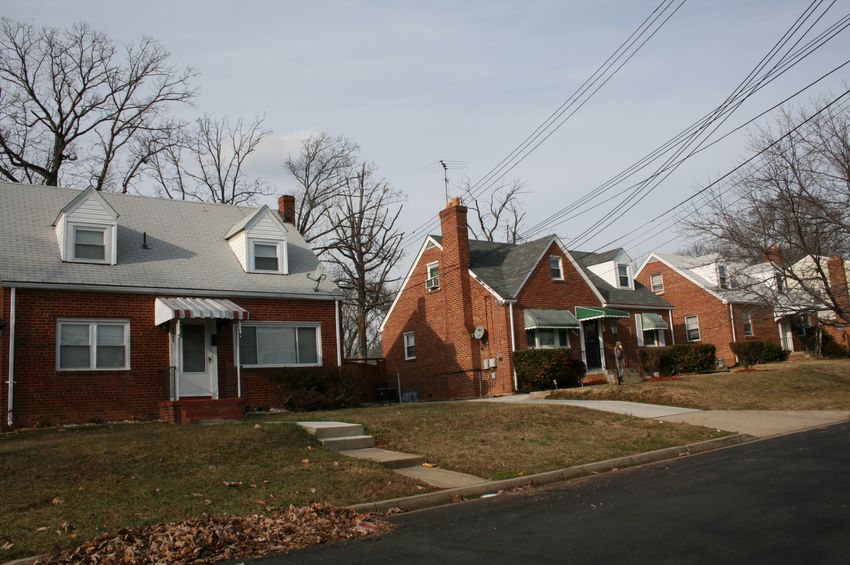
Hillcrest Heights (76A-000)            8

   Hillcrest Heights, Martenet, 1861
      = 2009 survey area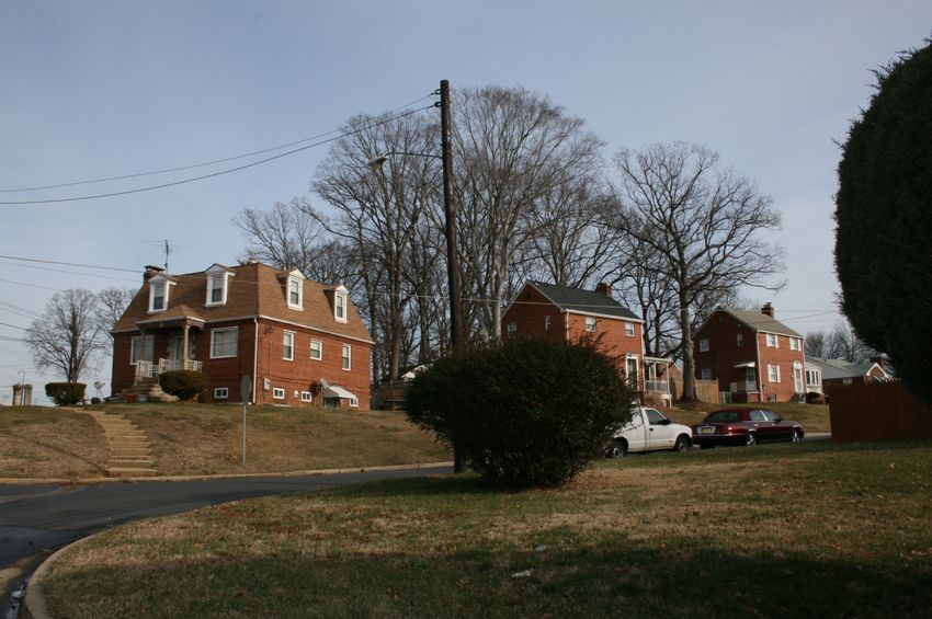
Hillcrest Heights (76A-000)           9

   Hillcrest Heights, Hopkins, 1878
      = 2009 survey area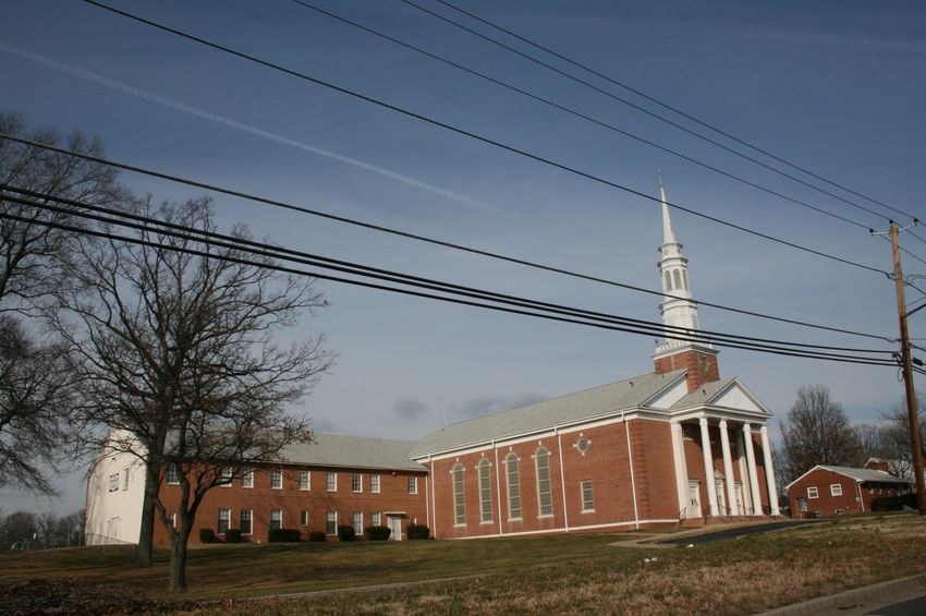
Hillcrest Heights (76A-000)           10

     Hillcrest Heights, 1938 aerial
      = 2009 survey area
Hillcrest Heights (76A-000) 11
Hillcrest Heights, 1965 aerial
= 2009 survey areaHillcrest Heights (76A-000) 12 Paul P. Stone’s “Home of ’48.” Display Ad, The Washington Post (12 September 1948), S8.
Hillcrest Heights (76A-000)                                                              13

John O. Aylor and Anthony Carozza’s “Home of ’49.” Display Ad, The Washington Post (18
September 1949), R8.
Hillcrest Heights (76A-000)                                                                14

Looking north, 3516-3518 29th Avenue (Lustron houses), Hillcrest Heights (EHT Traceries,
2009)
Hillcrest Heights (76A-000)                                                               15

Looking southwest, 3517 29th Avenue (Lustron house), Hillcrest Heights (EHT Traceries, 2009)
Hillcrest Heights (76A-000)                                                            16

Looking northwest, 2006-2008 Iverson Street, Hillcrest Heights (EHT Traceries, 2009)
Hillcrest Heights (76A-000)                                                                17

Looking northeast, Hillcrest Baptist Church, 2000 Iverson Street, Hillcrest Heights (EHT
Traceries, 2009)
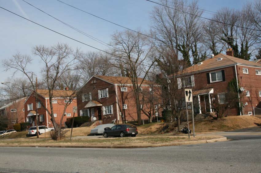
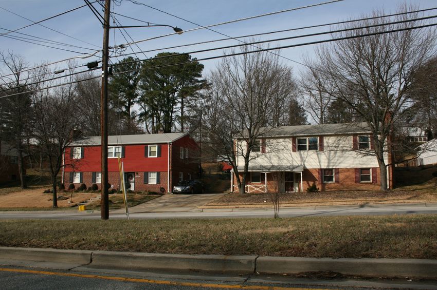
Hillcrest Heights (76A-000)                                                              18

Looking northeast, 4030/4028-4026/4024-4022/4020 Lyons Street (twin houses), Hillcrest
Heights (EHT Traceries, 2009)
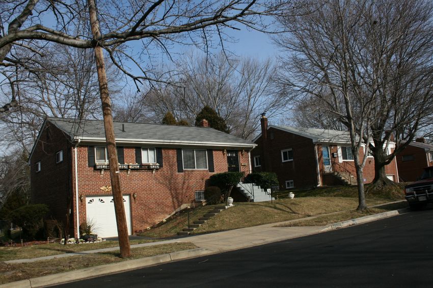
Hillcrest Heights (76A-000)                                                             19

Looking southeast, 4106-4108 St. Clair Place, Hillcrest Heights (EHT Traceries, 2009)
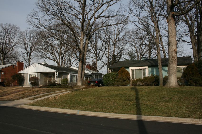
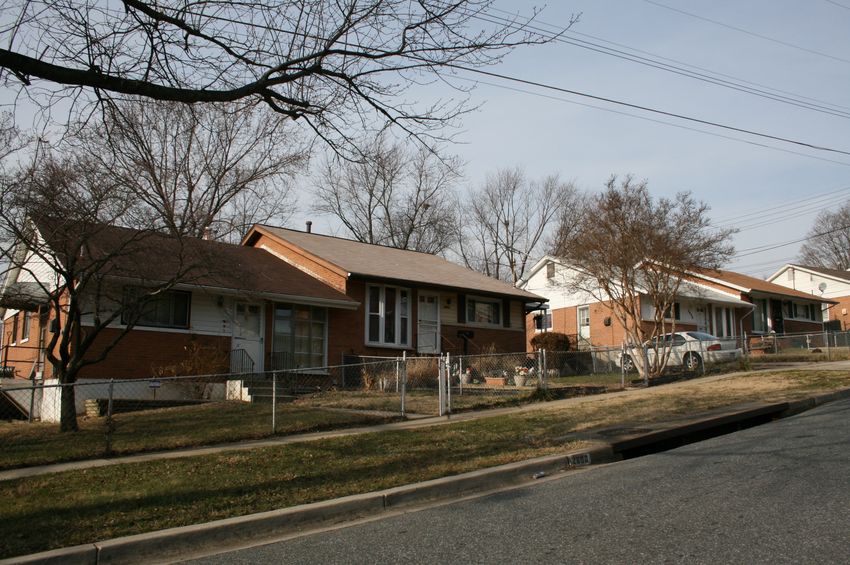
Hillcrest Heights (76A-000)                                                        20

Looking east, 4208-4210 Norcross Street, Hillcrest Heights (EHT Traceries, 2009)
Hillcrest Heights (76A-000)                                                              21

Looking northeast, 4409/4411-4413/4415 Lyons Street (twin houses), Marlow Heights (EHT
Traceries, 2009)
Hillcrest Heights (76A-000)                                                                 22

Looking northwest, Hillcrest Heights Library, 2398 Iverson Street, Hillcrest Heights (EHT
Traceries, 2009)
Hillcrest Heights (76A-000)                                                        23

Looking north, 2408-2410-2412 Colebrooke Drive, Colebrooke (EHT Traceries, 2009)
Hillcrest Heights (76A-000)                                                              24

Looking southeast, 2901 Fairlawn Street, 3602-3604 28th Parkway, Colebrooke (EHT Traceries,
2009)
Hillcrest Heights (76A-000)                                                              25

Looking southeast, 3503-3505-3507-3509 29th Place, Hillcrest Gardens (EHT Traceries, 2009)
Hillcrest Heights (76A-000)                                                          26

Looking southeast, 3525-3521 28th Parkway, Hillcrest Gardens (EHT Traceries, 2009)
Hillcrest Heights (76A-000)                                                                  27

Looking northeast, 2818/2820 Curtis Drive (twin houses), Hillcrest Gardens (EHT Traceries,
2009)
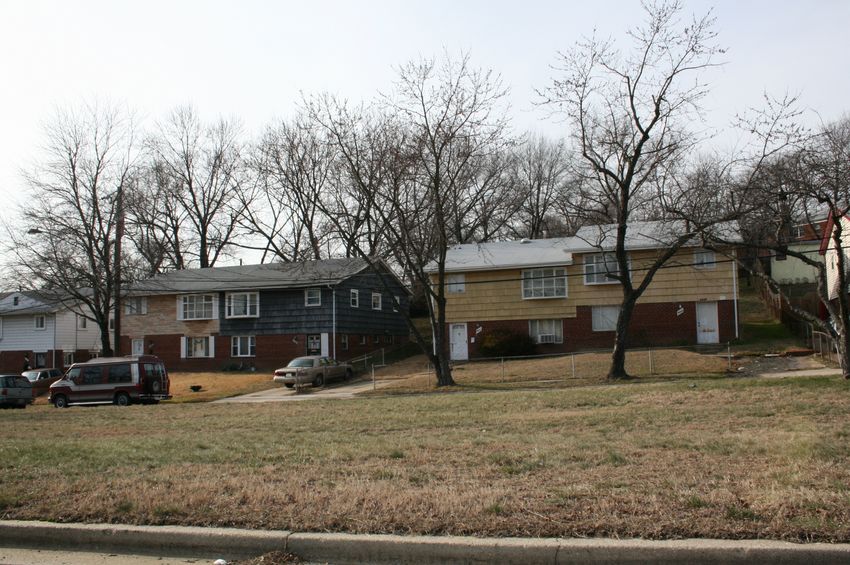
Hillcrest Heights (76A-000)                                                         28

Looking north, 3230/3228-3226/3224-3222/3220-3218/3216 32nd Avenue (twin houses),
Hillcrest Gardens (EHT Traceries, 2009)
Hillcrest Heights (76A-000)                                                           29

Looking north, 2600/2602-2604/2606 Afton Street (twin houses), Good Hope Hills (EHT
Traceries, 2009)
Hillcrest Heights (76A-000)                                                                 30

Looking southeast, 2403-2405-2407 Oxon Run Drive, Hillcrest Estates (EHT Traceries, 2009)
Hillcrest Heights (76A-000)                                                                 31

Looking south, Spirit of Faith Christian Center, 2261 Oxon Run Drive, Oxon Run Hills (EHT
Traceries, 2009)
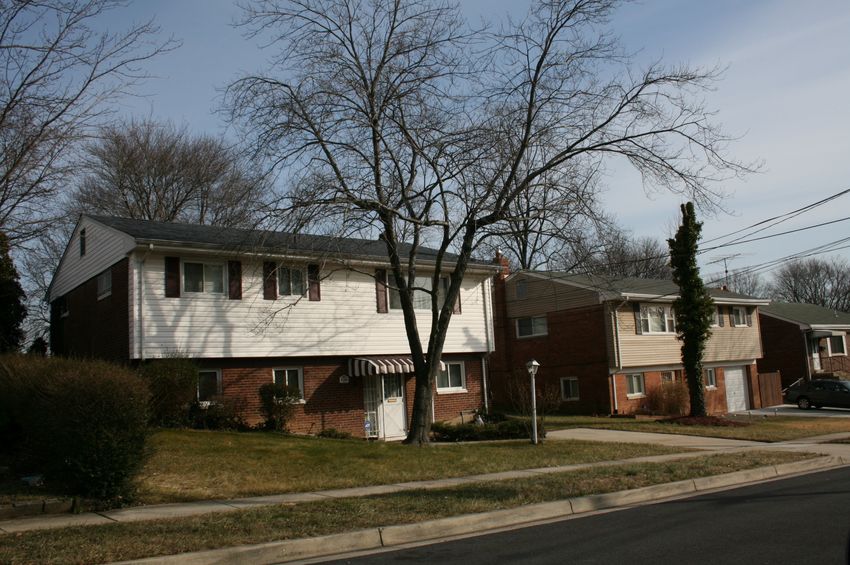
Hillcrest Heights (76A-000)                                                      32

Looking north, 3604-3602 23rd Parkway, Hillcrest Estates (EHT Traceries, 2009)
Hillcrest Heights (76A-000)                                                             33

Looking southeast, 2409-2411 Fairlawn Street, Hillcrest Heights (EHT Traceries, 2009)
Hillcrest Heights (76A-000)                                                             34

Looking northeast, 2414-2414 Fairlawn Street, Hillcrest Heights (EHT Traceries, 2009)
Hillcrest Heights (76A-000)                                                      35

Looking southeast, Corner of Colebrooke Drive and 25th Avenue, Iverson Village
Condominiums, Hillcrest Heights (EHT Traceries, 2009)
You can also read