Hung Kwai Chen Director of Water Resources Planning Institute, Water Resources Agency, MOEA - 2013 APEC Typhoon Symposium, 22 October
←
→
Page content transcription
If your browser does not render page correctly, please read the page content below
Hung‐Kwai Chen
                 Director of Water Resources Planning Institute,
                        Water Resources Agency, MOEA

2013 APEC Typhoon Symposium,
22 October
Outline
1. Overview on climate change adaptation studies of water
   agencies
2. Research achievements of water resources management
3. Research achievements of flood control and sediment
   management
4. Research achievements of coast protection
5. Promote the results on climate change adaptation studies
6. Next Stage
1. Overview on climate change
adaptation studies of water agencies
•During 1958~2012, more than 251 typhoon disaster events have been happened in
 Taiwan, and these events caused severe damage and a great number of casualties
 (18,915 people so far)

2004.7, Typhoon Mindulle
                                  Shimen reservoir dried up      2001.0.16, Typhoon Nari caused   2009, Typhoon Morakot attacked
caused the collapsing of
                                  during long-duration drought   the flooding in Taipei city      Zhiben hot spring area
Jianshan drainage levee

2004.7, Typhoon Mindulle
                                                                                                   2009, Typhoon Morakot
caused the collapsing of Taipei
                                                                                                   attacked Taimali River
river levee

                                  2001.7.11 , Typhoon Trami       2008.6.6 , heavy rainfall        2009, Typhoon Morakot
The sea is gradually                                                                               destroyed the Hsiao‐lin villagers,
                                  caused the flooding in          caused the flooding in
encroaching on the land                                                                            400 people missing.
                                  Kaohsiung City                  Kaohsiung city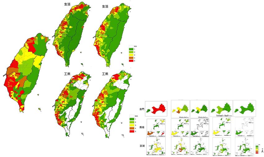
Frame work of WRA climate change adaptation studies

                              cooperative partner

                                                           WRA
     National Science and
    Technology Center for                       Water Resources Agency
      Disaster Reduction
                                   GCM                                                    Commissioned
          TCCIP
   (Taiwan Climate Change
                                                      Master Plan
   Projection & Information                    Climate Change Impacts and
           Platform)
                                 feedback     Adaptation to the Water Sector

                                    Others research
                                    results
                                                                feedback
                                    (A1B sea level rise,
                                    Rainfall , etc.)
                                                                               research
                                                                                            WRPI
      Review Committee                               Working Plan
                                  review
  Local government experts                          Water resources                       Water Resources
  Different Professionals                            Flooding、                            Planning Institute
  Etc…                                              Sediment…etc
1. NCDR assists WRA climate change scenario
settings and data (AR4).
GCM Settings
2. AR5 is being released in four parts between
September 2013 and November 2014. Statistical downscaling data
3. In NCDR preliminary project appraisal, our Total 24 models
GCM settings can cantain the variance of AR5 Monthly rainfall trends of Baseline and
Short-term basis period
and AR4.
pprecision of downscaling:
g 5km
A1B 24 GCM-International Dynamic downscaling data
Only 1 model(JP MRI)
Scenario common models
Monthly rainfall trends of Baseline and
Short-term basis period
precision of downscaling: 5km
Key issue Require data Settings
1. Daily Rainfall We chose 5 models that are applicable to East Asia and represent the possible
water resources
2. Daily temperature rainfall trend in future , and estimated daily rainfall from Monthly rainfall .
management
1. Hourly rainfall 1. We defined Monthly rainfall variance of flood‐dry period trend that is the
flood control 2. Estuary water level rises average value of 24 models added and reduced Standard Deviation , and
estimated the parameter of different rainfall events to define the hourly rainfall
data of short-term basis period.
sediment 2. We used the trend of historical sea level data to estimated estuary water level
1. Hourly rainfall
management rises of short-term basis period.
1. Sea level rises 1. We used the trend of historical sea level data to estimated sea level rises of
2. water level rises of storm short-term basis period.
coast protection
surge 2. We used the historical data of Typhoon attacked Taiwan to estimated water
level rises of storm surge.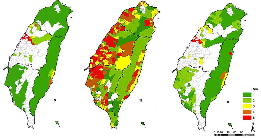
Second stage
                                                                                                            Working Plan
                        2010                 2011                 2012                 2013

                          Southern District                  North/Central/Eastern/Islands                Impacts and adaptation
                  impacts and adaptation of water resources impacts and adaptation of water resources     studies of water resource
water resource
                                                                                                          management of Taiwan
                   Review of water resource policies          Groundwater                                 region have been
management                                                                                                completed.
                                        Water Footprint     diversified water resources development`
                                               Risk of reservoir safety

                       Southern District, impacts and              Central District, impacts and
                           adaptation of drought                      adaptation of drought               Impacts and adaptation
flood control           Kao-Ping River , impacts and         Dan-Shui River , impacts and adaptation of   studies of 4 main Rivers
                         adaptation of flood control           flood control and sediment management      大甲溪
                                                                                                          in Taiwan(及中央管其他
                                                                                                                     will be
                         Development technology of flooding model                  Zhuo-shui River and
                                                                                                          completed) this year.
                                                                                                          16條河川
                                                                                   Céng-wén
sediment
                      Southern District, impacts and
                    adaptation of sediment management                              River , impacts and    尚待研究
                                                                                   adaptation of flood
management                Reservoir desilting                                      control and sediment   Impacts and adaptation
                                                                                   management             studies of southwest,
                   Evaluation of sea Disaster evaluation of                                               northwest and northeast
coast                 level rises     coastal and riverside area
protection             Southwest coast, impacts and
                                                                                                          coast protection will be
                                                             Northwest and northeast coast, impacts       completed this year.
                      adaptation of coast protection            and adaptation of coast protection
Integrated             Analysis of hydrological scenario      Evaluation of hydrological scenario          We will do the integrate
adaptation                                                                                                 impacts and adaptation
                                     System management and information service
                                                                                                           studies of river basin
Management of      1. Hydrological                                                                         with different field in
                      monitoring and                                                                       next stage.
information and       assessment in
monitoring            response to
                      climate change.
                   2. EU cooperation
Hot spots research achievements
Water resources Flood control and
management sediment management Coast protection
Northwest coast
Dan-Shui River 1. Completed
2. Sea level rises:
(2013) 7.53cm
Northeast
coast
(2013)
Da-jia river
(2014) Middle coast
(2014)
Zhuo-shui River
(2013)
East coast
(2015)
Southwest coast
(completed)
Ceng-wen River Sea level rises
1. 14.57cm
(2013) (Chianan area)
2. 14.35cm(Kaohsi
ung-Pingtung
area)
Kao-Ping River
(completed)
Studies of 4 main Rivers in Studies of southwest, northwest and
Studies of Taiwan region Taiwan will be completed this northeast coast protection will be
have been completed. year, and we will do the study completed this year, and we will
of Da-jia river in 2014. study other coast in next stage.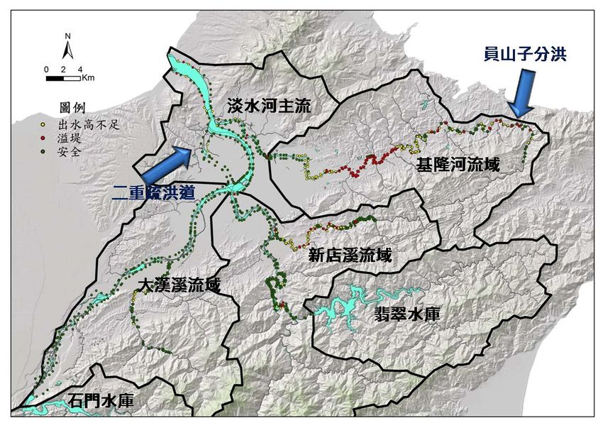
According to the Adaptation Strategy to Climate Change in Taiwan, WRA is responsible for coordinating the relevant departments to promote the Adaptation Action Plan of Water Resources Management to Climate Change in Taiwan, and this action plan have been completed.
2. Research achievements of water
      resources management
Scenario Settings
(Water Resources Management )
The Conclusion of 4 times of Scenario Review Committees in 2012.
1. Most GCM results show the scenario of the flood‐dry period rainfall will
be more and more uneven, which inferences that the model reflects certain
historical hydrologic behavior .
2. But we also can’t ignore the extreme estimations (few rainfall or heavy
rainfall all the year) of few models, and we still need to study these case if
this situation will cause serious impacts..
「較符合東亞季風特性」的GCM挑選結果
淡水河(網格點編號:191)
GCM在A1B情境下模擬結果 1.3
枯水期平均降雨變化
(網格點編號:191 ,淡水河流域) 1.2
「全年多雨情境」
1.1
建議採用模式
1
0.9
0.8
「全年少雨情境」
0.7
建議採用模式
0.8 0.9 1 1.1 1.2
豐水期平均降雨變化Annotate Risk of the Water Resources
R:Risk;H:Hazard;V:vulnerability
H:high;M:medium;L:low
Management
Main Impacts H V R
Because of the non‐rainy days increases and temperature rise, surface water
water resources will reduce. H M H
resources
development Because of the non‐rainy days increases, temperature rise and sea level rise, M LL L
groundwater resources will reduce.
Because of temperature rise , extreme rainfall intensity and the non‐rainy days
increases, water storage ability of reservoir will reduce. H M H
Because of extreme rainfall intensity increases, tapping water of reservoir will be
water more and more difficult . M M M
resources
Because of extreme rainfall intensity and the non‐rainy days increases, tapping
supply
water of river will be more and more difficult . M M M
Because of temperature rise , extreme rainfall intensity and the non‐rainy days H M
increases, eficiency of cleansing water will reduce.
L
Because of temperature rise and the non‐rainy days increases, water used
of agriculture will increase. H M H
water
resources Because of temperature rise, domestic water will increase. M M M
requirement
Because of temperature rise, industrial use water will increase. L M LThe risk of water resources management
According to the water resources management studies on climate change ,
the results show the regions have an acute shortage of water includes Miaoli,
Taichung, Changhua, Chiayi and Tainan ,etc.
70 Unit : Million m3/year 62.06
60
50 43.75
40 33.26
30
20 14.78 13.42
10.47 9.56
10
‐1.4 0.99
0 0 0 0 ‐3.76 ‐0.030.03
0
宜蘭
基隆
台北
板新
桃園
新竹
苗栗
台中
彰化
雲林
南投
嘉義
台南
高雄
屏東
花蓮
台東
金門
馬祖
澎湖
‐10 ‐8
‐14.11
‐20 ‐17 ‐17.17The risk of agricultural
water resources
The results show there are only some parts of Taiwan have the high
risk of agricultural water resources .
The white specific sections show the problem which is lack of the
distribution data of farmland, and we will consolidate the different
department’s information in order to study the integrated adaptation
in next stage.
Hazard Vulnerability RiskThe risk of public
Domestic water Domestic water water use
(Vulnerability) (Risk)
Public use water
(Hazard)
The results show the high risk
regions include Taoyuan, Hsinchu,
Changhua, Tainan and Kaohsiung.
公共用水 脆弱度 風險
危險度 生活 工業 生活 工業
Industrial use water
(Vulnerability)
Industrial use water
(Risk)Our Adaptation of Water Resources Adaptation of Water Resources
Management includes 4 strategies and each Management
strategy has practical measures.
Strategy No Measures
1 Addition of reservoir and water storage facilities
2 Addition of groundwater reservoir
3 Artificial lake
4 Rain-storing and recycling system
To strengthen and stabilize
5 Pond
the ability of water-supply
6 Under-flow water
capacity
7 Addition to well
8 Seawater desalination
Strengthen the water-supply ability of Water
9
Purification Station
10 Domestic water conservation programs
11 Agricultural water conservation programs
12 Adjustment of farming system
To active manage of the use 13 Water rights transfer system
of water 14 Reservoir dredging
15 Replace the old and leaky Water Supply Piping
16 Reduce the transmission loss of irrigation canal
17 Addition of Water Supply Piping
To strengthen the water 18 Reclamation, recycle and reuse of waste water
attemper management more
19 Interbasin water diversion
flexible
Strength monitoring of the supply and demand The red sections show the high risk of
To grasp the Climate Change 20
situation. water resource management.
impacts of the water
Collect and analysis the data of non climate
resources management 21
change factor3.Research achievements of flood control and sediment management
Rainfall & rainfall pattern of Tamsui River Basin                                                            A1B Scenarios
1.    We defined monthly rainfall variance of flood‐dry period that is the                                                            unit:mm
      average value of 24 models added and reduced Standard Deviation.
                                                                                                Station   Baseline        A1B         Ratio(%)
2.    In A1B scenarios, the most rainfall trend of the 13 rainfall stations in
                                                                                                淡水             519.0          615.9   18.67%
      Tamsui river basin increase 10~20%.                                                       臺北             581.3          679.2   16.84%
                                            14                                                  竹子湖           2183.3         2387.0    9.33%
                                                                                        碧湖
                                            12                                                  碧湖            1096.5         1103.3    0.62%
                                                                                        火燒寮
                                        降
                                          10                                            大豹      火燒寮           1451.7         1417.2    -2.38%
                                        雨
                                        百 8
                                                                                        瑞芳(2)   大豹             635.4          618.9    -2.60%
                                        分                                               大桶山     瑞芳(2)          949.7          874.9    -7.88%
                                                                                        五堵
                                        比 6
                                                                                        石門
                                                                                                大桶山            882.1         1071.1   21.43%
                                                                                                五堵            1089.5         1119.3    2.74%

                                        (
                                             4                                          高義
                                        %
                                                                                                石門
                                        )
                                             2                                          嘎拉賀                   1076.8         1160.0    7.73%
                                             0
                                                                                        白石
                                                                                                高義            1292.0         1081.8   -16.27%
                                                                                        淡水
                                                 1   5   9 13 17 21 25 29 33 37 41 45
                                                                                        臺北
                                                                                                嘎拉賀           1246.6         1132.5    -9.15%
                                                                 延時 (hr)
                                                                                                白石            1425.4         1638.4   14.94%
Rainfall trends of Rainfall trends of                                                               Rainfall of two-hundred-year return
 Baseline (1980- A1B Short-term         Rainfall pattern chart (SSGM, 48                            period & 48 hours continuous rainfall
     1999)         basis period         hours)
                   (2020-2039)

     Sea Level Raise
 1.    In A1B scenarios, the results show sea level                       The Tamsui River estuary water level of
       raise of Taipei area is 27cm in 2039.
                                                                          two-hundred-year return period is 4.3m
 2.    The sea level bulletin on Taipei Area Flood
       Control Project is EL+4.03 m
                                                                          (4.03m+0.27m) in 2039
1. For example of Tamsui River Basin, our impact analysis
The influence of flood
include the influence of flood carrying capacity of carrying capacity of river
river and sediment yield in A1B scenarios. A1B flood level
2. This page shows influence of flood carrying capacity of
river fist , and this chart is the simulation of steady unsafe Overbank
flow of 48 hours continuous rainfall in A1B scenarios. design levees level
And we can also find only a few of the river sections freeboard
freeboard for sale
not enough
are unsafe, but more parts of the river sections design flood level
freeboard aren’t enough. safe
Climate Change
sediment
yield extreme rainfall
Sea Level raise
volume intensity increases
increase
Peak Flow Estuary water
sediment intensity increases level raise
delivery
volume
increase Influence of the levees protecting
standards
The risk of multi‐
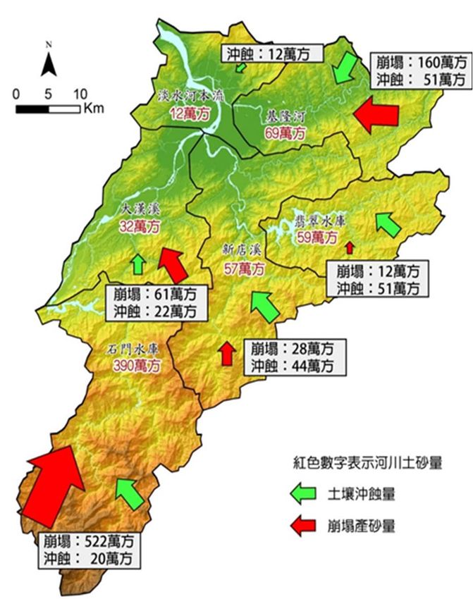
disaster increasesEvaluation the impacts of sediment The impacts of
yield by extreme rainfall(A1B)
sediment yield
Climate Change
0
sediment 12
extreme rainfall 160
yield 51
Sea Level raise
volume intensity increases
increase
Peak Flow Estuary water
sediment intensity increases level raise
delivery
volume
increase Influence of the levees protecting
standards 12
61 51
22
The risk of multi‐ 28
44
disaster increases
unit: 10,000 m3
Project baseline A1B variance
Landslide
Rate of sediment 55% 69% +25% sediment yield
Landslide sediment 187 783 +596 522 Soil erosion
20
yield(10,000 m3) Unit: 10,000 m3
Soil erosion(10,000 105 200 +95
m3)
In A1B scenarios, the total volume of sediment yield
of Tamsui River Basin are 6,200,000m3, the most of
Sediment 292 984 +692 the sediment yield are grouped in Shih-Men
yield(10,000 m3)
Reservoir.Adaptation of Flood Control
(Example of Kao-Ping River)
Strategy No Measures
According to the concepts of
1 確立氣候變遷對河川及都會區排水防護設施之衝擊
integrated basin management,
2 改善河川及都會區排水防護設施能力
our adaptations focus on
3 檢視與維護現有河川、都會區排水及水庫等防護設施的安全性
measures to disaster mitigation River and drainage
improvement 4 提升河川及都會區排水整體監控能力
and evacuation, includes
structure and non-structure 5 強化流域洪水分攤能量
measures. 6 強化河川綜合土砂管理
7 強化洪水平原管理
Dan-Shui River 8 強化易淹水地區土地利用管制
(2013) 9 推動耐洪建築物
Improve Disaster‐
resistant ability of 10 落實河川環境營造與管理
protected targets 11 推動易受災社區防災宣導與再教育訓練
Da-jia river
(2014) 12 規劃都市及非都市區多目標蓄洪空間
Zhuo-shui River 13 規劃完整洪水災害保險制度
(2013) 強化大規模洪水災害應變體系
14
Improve emergency
Ceng-wen River management and 15 精進洪水預報、警戒技術與通報系統
(2013) disaster emergency 16 更新與維護都市及非都市區避難設施
preparedness 17 制訂與演練緊急應變及避災作業程序
To grasp the Climate 18 氣候變遷對重要流域的衝擊評估
Kao-Ping River
Change impacts of the
(completed)
flood control 19 氣候變遷下重要流域的脆弱度與風險分析Adaptation of sediment management
(Example of Kao-Ping River)
Strategy No Measures
We will establish a rolling
確立氣候變遷極端事件下產砂量對河川相關 review of progress to
1
設施之衝擊
adjustment our adaptation
2 新建與改善集水區防砂壩等攔砂設施
program.
3 確立並持續監測集水區潛在崩塌區位
Improve 4 評估土砂於集水區或河川合理之遞移率
integrated 5 持續推動水庫/堰壩泥砂清淤改善
sediment
6 強化海岸與河道土砂穩定 Strategy No Measures
management
7 加強野溪治理 17 強化大規模土砂災害應變體系
8 持續進行沿岸漂砂監測 Improve 18 劃設並公告土砂警戒區域
9 設置合理的河道囚砂區域 emergency
management and 精進土石流預報、警戒技術與通報
10 持續推動沿岸沙洲保護與保全 19
系統
disaster
11 落實集水區環境營造與管理
Improve emergency 20 新建合適的避難設施
12 落實集水區土地利用管理 preparedness
Disaster‐ 制訂與演練緊急應變及避災作業程
13 推動山坡地產業利用之調整 21
resistant 序
ability of 14 推動社區防災宣導與再教育訓練 22 氣候變遷對土砂產量的衝擊評估
protected 15 強化水工結構物耐刷抗沖能力
To grasp the
targets Climate Change
16 規劃完整土砂災害保險制度 impacts of the 氣候變遷下重要流域的土砂災害風
sediment 23
險分析
management4.RESEARCH ACHIEVEMENTS OF COAST PROTECTION
A1B Scenarios Sea level raise scenarios We estimated the trend of sea level rises of short-term basis period on the basis of Taichung Harbor tide-gage station The results of A1B Short-term basis period (2020-2039) show the maximum wave height increase 50.3% and the maximum tidal stage increase 38% during the typhoon period, and the results also show the numbers of typhoon events increase 19.3% .
The impacts of Northwest coast
  coastal                       year return period
   levee               5   10   20   50 100 150 200 250
                                                            protection (Taoyuan area )
 Sha-lun    Baseline   O   O    O    X   X   X   X   X
  levee       A1B      X   X    X    X   X   X   X   X
  Xin-jie   Baseline   O   O    O    X   X   X   X   X
  levee       A1B      X   X    X    X   X   X   X   X
 Nei-hai    Baseline   O   O    O    X   X   X   X   X
  levee       A1B      X   X    X    X   X   X   X   X
Bei-gang Baseline      O   O    O    O O O O         X
 levee     A1B         O   O    X    X   X   X   X   X
 Shu-lin    Baseline   O   O    O    X   X   X   X   X
  levee       A1B      X   X    X    X   X   X   X   X
  Bai-yu    Baseline   O   O    O    X   X   X   X   X
  levee       A1B      X   X    X    X   X   X   X   X
Yong-an Baseline       O   O    O    O O O       X   X
1st levee A1B          O   X    X    X   X   X   X   X
Yong-an Baseline       O   O    O    X   X   X   X   X    ※ 觀音海堤因已形成內陸堤,不列入計算範圍。
2st levee A1B          O   X    X    X   X   X   X   X    Mark O represent the amount of overtopping
Ben_gan Baseline       O   O    O    X   X   X   X   X    water is less than 0.02 c.m.s.
 levee    A1B          X   X    X    X   X   X   X   X
                                                          Mark X represent the amount of overtopping
Shen-zhen Baseline     O   O    O    X   X   X   X   X
                                                          water is over than 0.02 c.m.s.
  levee     A1B        X   X    X    X   X   X   X   X
  He-Ke     Baseline   O   O    O    X   X   X   X   X    Data source:
  levee       A1B      X   X    X    X   X   X   X   X    A study of adaptation capacity of coastal disasters due to
                                                          climate change in order to strengthen northwest and
                                                          northeast areas of Taiwan (1/2),2012.
The risk of Northwest coast
protection
Hazard Vulnerability Risk
The Hsinchu area’s risk level
is 5 , others are 4 and 3. Taoyuan area
Climate Change
Hsinchu area
Sea level raise Surge leve raise
the flow over the
coastal levee increase
Influence of the levees protecting
standards
Miaoli area
The risk of
flooding increasesProtective projec of The adaptation draft of
adaptation program
northwest coast protection
Action plan
改善沿海排水系統 We divide our adaptation program into 3 projects with
製作脆弱度與風險地圖 different characteristics of protective, adaptable and
規劃海岸保護區 retractive , and divide the action plans of each project into
規劃設施毀壞補救辦法 short-term , mid-term and long term plans.
地層下陷控制 Our protective project has 7 action plans, adaptable project
完善工程技術與管理 has 4 action plans, and retractive project has 4 action plans.
持續海平面變遷之監測 We will establish a rolling review of progress to adjustment
Adaptable projet of our adaptation program.
adaptation program
Northwest coast
Action plan 1. Completed
2. Sea level rises:
提升海岸防護設施強度 7.53cm Northeast
coast
堤前灘地之保護 (2013)
推動海岸保護法規 Middle coast
維護海岸自然生態環境 (2014)
Retractive projec of
adaptation program
East coast
(2015)
Action plan
限制海岸地區開發計畫 Southwest coast
(completed)
強化海岸災害應變計畫 Sea level rises
1. 14.57cm
規劃海岸災害緩衝區 (Chianan area)
2. 14.35cm(Kaohsi
擬定整合性海岸地區管理計畫 ung-Pingtung
area)5. Promote of studies results on Climate Change Adaptation
帶動系列活動
                 的火車頭
   Citizen
participation

                                                      4
                                                          Poster

                                  2                                3    Presentation,
                  1    Citizen         International                    Education and
                                        symposium                          Training
                        Cafe

                2012/11/17        2013/01/15~16                        2013/01/17
                National Cheng    National Central Library         GIS convention Center, NTU
                Kung University
The Citizen Participation Workshops and Issue Collections
of National Climate Change Conference
1.Citizen Cafe
Table
Topic of discussion
Number
How to improve the diversified water resources
development? How to promote the active plan of 背景
Water resources
1
management
water resources and water reclamation?
說明
How to stable supply the public water use and
2 establish water saving society?
How to adjust water use structure reasonable and
3 promote water use efficiency ? 分組
How to adapt the long‐duration drought under
4 climate change? 討論
How to keep the sustainable development of
5 water resources facilities under climate change?
control
Flood
6 How to strengthen the basin management? 具體
7
How to adapt the impacts of sea level raise to 建議
coastland under climate change?
protecti
How to adapt the impacts of Urban flood control
Cost
8
on
under climate change?
How to conform locals to establish the Disaster 凝聚
9 Resistant Communities ? 共識
management
Sediment
How to strength the conservation of basin and
10 river dredging of downstream under the sediment
disasters?2.International symposium
International symposium was organized by
WRA and NCDR
speakers:22 experts (12 domestic experts and
10 international experts)
International experts Topic
韓國 Climate change adaptation policy and future direction in
Young-Han Kwon(KACCC) Korea
荷蘭 The water footprint of humanity – the global dimension
Arjen Hoekstra (Univ. of Twente) of water Management
Domestic experts Topic
童慶斌、張良正 水資源管理
Strengthening water supply system adaptive capacity to climate change in
以及林裕彬 教授 Taiwan
水文情境
鄭克聲 教授 Assessment of hydrologic projections under climate change
海岸防護
許泰文 教授 Adaptation capacity of coastal disasters due to climate change to
strengthen northwest area of Taiwan3.Presentation, Education and Training
Education and Training of Water
Presentation(morning session) footprint(afternoon session)
1. Impacts and adaptation of water 講者:Prof. Arjen Hoekstra
resources management
(水足跡原創者)
講者:劉子明 博士
內容:
內容:
1. 水足跡概念介紹
水資源管理衝擊與調適
2. 產業案例
研究方法論
3. 水資源管理應用成果
TAIWAP模式
2. Analysis method of Hydrological 學員除水利從業人員外,亦包
Scenario 括學術界及產業界。
講者:鄭克聲 教授
內容:
水文情境評估方法論
序率暴雨模式4.Post
Hydrological Scenario
Flood control & Sediment
Rainfall Scenario & Risk Map of 4 key issue
Coast protection management
Water resources
management6.Next Stage
All projects in second stage have been completed.

Water Resources Management:
 • The risk map of water resources management & water resources supply of Taiwan have
   been completed.
 • There are 112 villages in high risk situation of water-supply capacity in the future.
 • Adaptation Action Plan of Water Resources Management to Climate Change in Taiwan
   have been completed.
Flood Control and Sediment Management
 • Studies of Dan-Shui River, Da-jia river, Zhuo-shui River, Ceng-wen River, Kao-Ping
   River(update) will be completed this year.
 • According to the studies, we will establish a rolling review of progress to adjustment
   our adaptation program.
 • We will do the integrate impacts and adaptation studies of river basin with different
   field (water resources, reservoir, coast, etc.) in next stage.
Coast Protection:
 • Studies of southwest, northwest and northeast coast protection will be completed this
   year.
 • The Hsinchu area’s risk level is 5 , others are 4 and 3 in northeast area.
The Third Stage Working Plan
                                                                  (initial plan)
                    2014               2015               2016               2017               2018

                  To find the hot spots of Water Resources Facilities and the Vulnerability Analysis and
water
                                           Demonstration Plans of these facilities.
resource
management                                          The analysis and conformity of Inter-departmental
                Da-jia River
                                                    Water Resources Management.
                Imapcts and
flood control   adaptation
and sediment
management      The Study of the impacts and adaptations of Urban flood control due to Climate
                Change.
                The Study of the impacts and         Demonstration adaptation Plans of coast
coast           adaptations of East coast,
protection      Middle coast and Islands.            protection due to climate change.

                The study of the integrate Adaptation and Demonstration Plans of river basin with
                multi-field.(Cen-Wen River Basin)
Integrated      The study of Adaptation and Demonstration Plans to analy and
adaptation      conform the hot spots’ Flood Control and Land Use .
                The study of adaptation and demonstration Plans to conform the hot
                spots’ Water Resources Management and Agriculture.
                The study of Assessment of Hydrologic Scenarios Review under IPCC AR5.
Management
of
                system management /information service / promote adaptation/ international exchanges /
information
and                                               ppromote results
monitoring                       The conformity of adaptation indicative/ Analysis of adaptation
                                                   benifet / Education of adaptation
Thank You For Your Attention
You can also read