Identifying habitat and understanding movement resistance for the Endangered Bornean banteng Bos javanicus lowi in Sabah, Malaysia-ORCA
←
→
Page content transcription
If your browser does not render page correctly, please read the page content below
Identifying habitat and understanding movement
resistance for the Endangered Bornean banteng
Bos javanicus lowi in Sabah, Malaysia
HONG YE LIM, PENNY C. GARDNER, NICOLA K. ABRAM
K A L S U M M . Y U S A H and B E N O I T G O O S S E N S
Abstract Habitat prioritization and corridor restoration are Keywords Bornean banteng, Borneo, Bos javanicus lowi,
important steps for reconnecting fragmented habitats and conservation, habitat suitability, maximum entropy,
species populations, and spatial modelling approaches are use- movement resistance, Sabah
ful in identifying suitable habitat for elusive tropical rainforest
Supplementary material for this article is available at
mammals. The Endangered Bornean banteng Bos javanicus
https://doi.org/./S
lowi, a wild bovid endemic to Borneo, occurs in habitat that
is highly fragmented as a result of extensive agricultural ex-
pansion. Based on the species’ historical distribution in
Sabah (Malaysia), we conducted camera-trap surveys in
Introduction
forest reserves during –. To assess suitable habitat
for the banteng we used a presence-only maximum entropy
(MaxEnt) approach with spatial predictors, including cli-
mate, infrastructure, land cover and land use, and topography
H uman-induced destruction of natural ecosystems
is one of the major threats to global biodiversity
(Cincotta et al., ), with c. % of all known species
variables. We performed a least-cost path analysis using threatened by destructive human activities (IUCN, ).
Linkage Mapper, to understand the resistance to movement Endemic species of Borneo are among the most vulnerable
through the landscape. The surveys comprised a total of to timber extraction, deforestation for oil palm, habitat
, nights of camera trapping. We recorded banteng pres- fragmentation and poaching (Gaveau et al., ; Hoffmann
ence in forest reserves. Key spatial predictors deemed to be et al., ). Effective protection of these species requires
important in predicting suitable habitat included soil associa- a strategic conservation approach, involving in particular
tions (.%), distance to intact and logged forests (.%), habitat protection and connectivity restoration (Koh &
precipitation in the driest quarter (.%), distance to agro- Sodhi, ).
forest and regenerating forest (.%), and distance to oil In this study our focal species was the Bornean banteng
palm plantations (.%). Circa % of Sabah had suitable habi- Bos javanicus lowi, a wild bovid subspecies endemic to
tat (, km), of which .% was in protected forests, .% Borneo (Gardner et al., ; Ishige et al., ). There are
was in production forests and .% was in other areas. The two other subspecies, the mainland banteng B. javanicus
least-cost path model predicted linkages and a relatively birmanicus (Indochina) and the Javan banteng B. javanicus
high movement resistance between core habitats. Our models javanicus (Java and Bali); all three are categorized as
provide information about key habitat and movement resist- Endangered on the IUCN Red List (Gardner et al., ).
ance for bantengs through the landscape, which is crucial for Bornean bantengs inhabit primary and secondary diptero-
constructive conservation strategies and land-use planning. carp and swamp forests and are best described as mixed-
feeders (Gardner et al., ). They endure secondary forest
conditions and benefit from the temporary increases
HONG YE LIM* (Corresponding author, orcid.org/0000-0003-0699-5187) and
KALSUM M. YUSAH Institute for Tropical Biology and Conservation, Universiti
in regenerating vegetation in early stages of a logged
Malaysia Sabah, Kota Kinabalu, Sabah, Malaysia forest but only when human disturbances are infrequent
E-mail limhongye90@gmail.com (Gardner, ; Prosser et al., ; Journeaux et al., ).
PENNY C. GARDNER† and BENOIT GOOSSENS†‡ Danau Girang Field Centre, Sabah When the ambient temperature is high they rest in the
Wildlife Department, Kota Kinabalu, Sabah, Malaysia
shade of closed canopy forest to reduce heat stress and
NICOLA K. ABRAM§ Living Landscape Alliance, Berkshire, UK avoid dehydration (Gardner, ). They favour foraging
*Also at: Danau Girang Field Centre, Sabah Wildlife Department, Wisma Muis, ground close to permanent water sources, where they
Kota Kinabalu, Sabah, Malaysia
†Also at: Organisms and Environment Division, Cardiff School of Biosciences, also socialize (Davies & Payne, ). Deforestation and
Cardiff University, UK the establishment of extensive monoculture plantations,
‡Also at: Sustainable Places Research Institute, Cardiff University, Cardiff, UK especially of oil palm, have resulted in a highly frag-
§Also at: ARC Centre of Excellence for Environmental Decisions, The
University of Queensland, Brisbane, Australia mented population (Gardner, ).
Received February . Revision requested April . Banteng occurrence records in Sarawak (Malaysian
Accepted August . First published online May . Borneo), Brunei and Kalimantan (Indonesian Borneo) are
This is an Open Access article, distributed under the terms of the Creative Commons Attribution licence (http://creativecommons.org/licenses/by/4.0/), which permits unrestricted re-use,
Downloaded from https://www.cambridge.org/core.
distribution, IP address:
and reproduction in any medium, 82.16.166.249,
provided on 03
the original work is Feb 2021cited.
properly at 14:35:02, subject to the Cambridge Core terms of use, available at
https://www.cambridge.org/core/terms. https://doi.org/10.1017/S0030605318001126
Oryx, 2021, 55(1), 122–130 © The Author(s), 2019. Published by Cambridge University Press on behalf of Fauna & Flora International doi:10.1017/S0030605318001126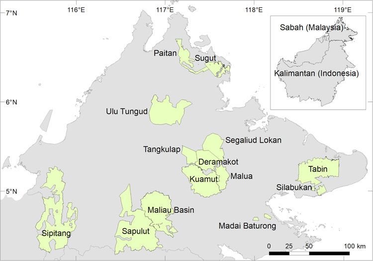
Bornean banteng in Sabah, Malaysia 123
scarce and our understanding of the banteng’s distribution the Species Action Plan for the Bornean banteng, and other
across its range in Borneo is limited (Gardner et al., ). conservation efforts in Sabah.
For Sabah, Davies & Payne () published the first state-
wide banteng distribution map, and estimated a population
size of c. – individuals. However, the community Study area
interviews and sign surveys they used were dependent on
Our study covered the Malaysian state of Sabah, in the
accessibility. Boonratana () used line transects to iden-
north of Borneo. Based on the historical distribution of the
tify banteng presence in several forest reserves in Sabah,
Bornean banteng (Davies & Payne, ), we conducted
and estimated the population to be , individuals.
camera-trap surveys in forest reserves (Fig. ). Forests in
Indirect density estimation based on dung was impossible
these reserves consisted of primary and secondary tropical
because of low encounter rates along the line transects,
lowland and mixed hill dipterocarp forest, montane forest
which covered a total distance of km. Gardner ()
and seasonal swamp forest. A history of various management
estimated the population size in Tabin Wildlife Reserve
approaches and timber harvesting regimes has resulted in an
( individuals) and Malua Forest Reserve ( individuals)
extensive network of logging roads, trails and openings. In
using photographic evidence captured by camera traps.
Sabah forests are categorized as Protection Forest Reserves,
Localized extinctions have occurred in the Dent Peninsula
Production Forest Reserves and Protected Areas. Both
of Sabah (Gardner, ).
Protection and Production Forest Reserves are under
The increasing availability of spatial modelling ap-
the authority of Sabah Forestry Department, whereas
proaches, and higher-quality and relevant environmental
Protected Areas are governed by Sabah Parks and Sabah
data facilitate habitat prioritization and connectivity restor-
Wildlife Department (Supplementary Material ; Sabah
ation (Beier et al., ; Elith & Leathwick, ). However,
Forestry Department, ).
spatial modelling has not been used previously to examine
distribution patterns of the Bornean banteng. Among the
available modelling methods, maximum entropy (MaxEnt) Methods
is popular because it can model presence-only data and
multidimensional interactions between variables (Elith Camera trapping
et al., ). Trisurat et al. () used MaxEnt to model
current and future distribution patterns of the mainland We deployed Reconyx HC and PC camera traps
banteng in northern Thailand under scenarios of changes (Reconyx Inc., Holmen, USA) in the forest reserves dur-
in land use and climate, and highlighted areas in need of ing – to detect the occurrence of Bornean bantengs,
protection. MaxEnt has also been used for distribution using grid (Gardner, ) and opportunistic sampling de-
modelling for other Bornean and Malayan taxa; e.g. the signs (Supplementary Table ). Four grids were established
flat-headed cat Prionailurus planiceps, Malayan sun in Tabin Wildlife Reserve and three in Malua Forest Reserve
bear Helarctos malayanus and Bornean ferret badger (Gardner, ). To avoid resampling the same banteng
Melogale everetti (Wilting et al., , ; Nazeri et al., herds, the grids were spaced at least km apart, as bantengs
). have been observed to travel at least km (Gardner et al.,
Identifying potential connectivity for reconnecting forest ). The distance between camera-trap stations in each
fragments is crucial for the banteng, as habitat fragmen- grid was c. m, to increase the chances of detection
tation has disrupted movement and, potentially, gene (Gardner, ). The total number of camera-trap stations
flow (Hu et al., ; Gardner, ). Linkage Mapper used in the grid surveys was . We employed an opportun-
(McRae & Kavanagh, ) can be used to simulate potential istic sampling design in the remaining forest reserves, to
wildlife corridors and movement resistance. Brodie et al. locate remnants of the banteng population. A total of
() predicted and compared efficiency between multi- camera-trap stations were established in these reserves,
species and single-species corridors in Borneo but excluded based on the presence of banteng signs such as footprints
the Bornean banteng from the analysis because of its and dung, on wildlife trails, riverbanks, ridges, active and
restricted distribution. abandoned logging roads, stumping sites and in both open
A better understanding of current banteng distribution and closed-canopy conditions. Each camera-trap station
and identification of suitable habitats and movement resis- comprised two opposing camera traps and captured three
tance across Sabah are necessary for planning and drafting images per trigger (one image per second), each stamped
policy to protect the species. The aim of this study was there- with the time, date and ambient temperature. We recorded
fore to enhance our knowledge of the distribution of the the location of each station using a GPS. All stations
Bornean banteng in Sabah, Malaysia, by identifying suitable operated h per day for at least days. Every days
habitat and then estimating the resistance of movement of we performed maintenance checks to ensure functionality
banteng between habitat patches. This research will inform of camera traps and retrieve data.
Oryx, 2021, 55(1), 122–130 © The Author(s), 2019. Published by Cambridge University Press on behalf of Fauna & Flora International doi:10.1017/S0030605318001126
Downloaded from https://www.cambridge.org/core. IP address: 82.16.166.249, on 03 Feb 2021 at 14:35:02, subject to the Cambridge Core terms of use, available at
https://www.cambridge.org/core/terms. https://doi.org/10.1017/S0030605318001126124 H. Y. Lim et al.
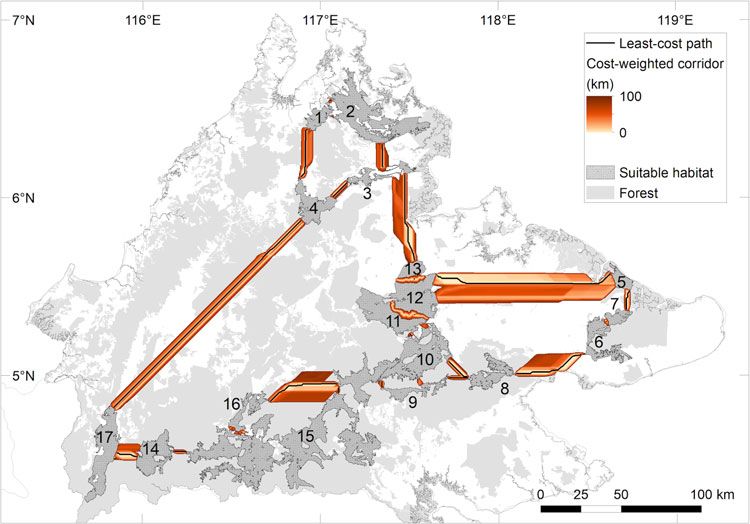
FIG. 1 Areas surveyed for the
Bornean banteng Bos javanicus
lowi in Sabah, Malaysia.
Preparation of banteng occurrence data for MaxEnt We assessed various combinations of the number of back-
ground points, regularization multiplier and features,
MaxEnt uses presence-only data against background points. selected the parameters with area under the receiver
We used the coordinates of the stations at which bantengs operating curve (AUC) . . and less overfitting, and pre-
were positively identified for our presence-only dataset. To dicted all areas where bantengs were present. The final
minimize the effect of spatial autocorrelation, presence data model specifications were , background points, a
were filtered by creating a -km circular buffer around each regularization multiplier of ., linear, quadratic and pro-
camera station (in ArcGIS .; ESRI, Redlands, USA) and duct features, iterations, true response curves, true
removing points within the buffer. jackknife test to measure variable importance, and logistic
output. We chose a threshold of . based on the preva-
lence of banteng occurrence in our presence–absence data-
Preparation of spatial predictors set. To account for sampling bias we included a bias grid
We used spatial predictors, covering climate, infrastruc- raster layer in the modelling process (Syfert et al., ).
ture, land cover and land use, soil, and topographical Point density in ArcGIS was used to generate the bias grid
variables, to describe the environmental conditions of raster; the neighbourhood was set to a default. To avoid
the landscape (Supplementary Tables ,). These facilitate MaxEnt dropping the bias grid raster during the modelling,
multidimensional exploration of the impact of precipita- all zero values of the bias grid raster were converted to
tion and temperature variation, geographical features and .. A nested -fold cross-validation was applied
human-induced modification of natural landscapes. to evaluate the predictive performance of the model using
These predictors were extracted at a -m resolution the AUC score, which indicates the model’s ability to
(,, cells) covering the state of Sabah, excluding discriminate between presence and absence: , ., poor;
several small islands. .–., low, but better than chance; .–., intermediate;
. ., high (Manel et al., ). To build a binary map of
suitable and unsuitable habitats, four commonly used
Habitat suitability modelling thresholds were assessed visually, namely minimum train-
ing presence, ten percentile training presence, equal training
We used MaxEnt v...k (Phillips et al., ; Phillips & sensitivity and specificity, and maximum training sensitivity
Dudík, ) to associate the spatial predictors with the and specificity (Liu et al., , ). To take into account
presence data. The MaxEnt approach is suitable for model- all banteng habitat for protection, we selected the threshold
ling a rare and low-density mobile species that occurs in a that predicted the widest coverage of suitable areas. The
tropical rainforest where absence data can be highly unreli- suitable areas were restricted to forested areas, using a
able and data collection is often difficult (Elith et al., ). generic forest layer digitized from SPOT and satellite
Oryx, 2021, 55(1), 122–130 © The Author(s), 2019. Published by Cambridge University Press on behalf of Fauna & Flora International doi:10.1017/S0030605318001126
Downloaded from https://www.cambridge.org/core. IP address: 82.16.166.249, on 03 Feb 2021 at 14:35:02, subject to the Cambridge Core terms of use, available at
https://www.cambridge.org/core/terms. https://doi.org/10.1017/S0030605318001126Bornean banteng in Sabah, Malaysia 125
images from and . This is because we assume the TABLE 1 Per cent contribution of spatial variables to the habitat
Bornean banteng to be largely a forest-dependent species, suitability model for the Bornean banteng Bos javanicus lowi.
and therefore we considered areas of oil palm, smallholdings Environmental predictors % contribution
and settlements to be unsuitable. Areas , km were
Soil association 52.6
removed, as bantengs travel at least km (Gardner et al., Distance to intact & logged forest 11.8
). Areas $ km were assigned as core areas. Precipitation of driest quarter 10.8
Distance to agro- & regenerating forest 5.7
Distance to oil palm 5.1
Least-cost path analysis Distance to major river 3.5
Seasonality of precipitation 3.2
We performed a least-cost path analysis using Linkage Distance to asphalt & gravel road 2.3
Mapper v... (McRae & Kavanagh, ), to examine the Distance to severely degraded forest 2.2
movement resistance for the Bornean banteng across the Elevation 1.8
Sabah landscape. The core suitable area was extracted and Annual temperature range 1.2
exported as a polygon shapefile (WHCWG, ). To create
a resistance layer, the continuous habitat suitability raster within or close to intact or logged forests (Fig. b), and
layer was inverted and rescaled to – (Stevenson-Holt in areas with relatively higher precipitation in the driest
et al., ). As Linkage Mapper does not simulate cells quarter of the year (Fig. c). The relationship between
with no value, they were converted to . Given the lack of habitat suitability and distance to oil palm and agro- and
knowledge in determining the optimal corridor width for regenerating forests increased with distance up to km
bantengs, the effect of various corridor cut-off widths (, , (Fig. d,e; Supplementary Fig. ).
, and km cost-weighted distance) on the movement We selected the minimum training presence threshold
resistance output were evaluated (Dutta et al., ). (Supplementary Fig. ) to define categories of suitable and
unsuitable areas on the habitat suitability model, as it had
zero omission rate and predicted the widest distribution of
Results
habitat for bantengs compared to other thresholds. Circa
% (, km) of Sabah was predicted to have suitable
Camera trapping
habitat, c. % ( km) of which was within Protected
Because of electronic failure and malfunction, and unwar- Areas and Protection Forest Reserves, % (, km) was
ranted human activities, the total number of camera-trap within Production Forest Reserves, and % (, km)
nights was ,, and we obtained presence and was outside these areas (Table ; Fig. ).
absence data points. Bantengs were present in of the
sites, namely Tabin Wildlife Reserve, Maliau Basin Least-cost path and movement resistance
Conservation Area (buffer zone), and Malua, Deramakot,
Tangkulap, Segaliud–Lokan, Kuamut, Sipitang, Sapulut, We identified core habitat areas (–, km) for
Sugut and Paitan Forest Reserves. After filtering was applied, bantengs, with a majority concentrated within the central
presence data points remained and were used for the forest (Supplementary Table ; Fig. ). The least-cost path
analysis. Our camera traps also detected two snare injuries: model estimated corridors. The least-cost path distance
a cow with a swollen hoof in Sugut and a bull with a missing was .–. km, with a mean of ± SD . km. The
hoof in Segaliud–Lokan. cost-weighted distance was .–, km, with a mean of
,. ± SD ,. km. The mean ratio of cost-weighted
distance to least-cost path was . ± SD ., indicating a
Habitat suitability relatively high movement resistance for travelling between
The habitat suitability model had a high AUC score the core areas. The path connecting core areas and
for model fitting (.) and -fold cross-validation (both within Deramakot) was the least costly for bantengs
(mean = . ± SD .). The five most influential spatial (.). The path between core areas and (Segaliud and
predictors were soil association (i.e. .% of the model Kulamba) was the most costly (.). The km cut-off
contributed by soil association compared with the other width was selected because . % of the cost-weighted cor-
predictors), distance to intact and logged forests (.%), ridors contained . % forest and , % oil palm (Fig. ).
precipitation in the driest quarter (.%), distance to
agro- and regenerating forest (.%), and distance to oil Discussion
palm (.%; Table ). Suitable habitat was highly associated
with specific soil types, especially Kalabakan, Labau and Continuous habitat loss, fragmentation and poaching are
Lokan (numbers , and , respectively, in Fig. a), the major threats to the Bornean banteng in Sabah. The
Oryx, 2021, 55(1), 122–130 © The Author(s), 2019. Published by Cambridge University Press on behalf of Fauna & Flora International doi:10.1017/S0030605318001126
Downloaded from https://www.cambridge.org/core. IP address: 82.16.166.249, on 03 Feb 2021 at 14:35:02, subject to the Cambridge Core terms of use, available at
https://www.cambridge.org/core/terms. https://doi.org/10.1017/S0030605318001126126 H. Y. Lim et al.
FIG. 2 Top five most
influential spatial predictors in
the MaxEnt model of habitat
suitability for the Bornean
banteng: (a) soil association
(.%); (b) distance to intact
and logged forest (.%);
(c) precipitation of driest
quarter (.%); (d) distance to
agroforest and regenerating
forest (.%); and (e) distance
to oil palm plantations (.%).
dearth of up-to-date knowledge of distribution and popula- between soil types and habitat suitability, especially in
tion size impedes conservation of this threatened species. Kalabakan, Lokan and Labau. Although the relationship
Our goal was to describe the current distribution of suitable between mammals and soil variability in Borneo is under-
habitat, and movement resistance for bantengs. studied, soil types may have indirect impacts on wildlife
habitats as a result of floristic patterns (Woinarski et al.,
). Variation in soil nutrient content determines tropical
Habitat suitability
floristic composition, density and distribution (Paoli et al.,
Across Sabah we predicted that c. % of the land area has ). Sedimentary soils (in Kalabakan and Labau) are
suitable habitat for bantengs. We found a strong association common in both lowland and highland areas, whereas
Oryx, 2021, 55(1), 122–130 © The Author(s), 2019. Published by Cambridge University Press on behalf of Fauna & Flora International doi:10.1017/S0030605318001126
Downloaded from https://www.cambridge.org/core. IP address: 82.16.166.249, on 03 Feb 2021 at 14:35:02, subject to the Cambridge Core terms of use, available at
https://www.cambridge.org/core/terms. https://doi.org/10.1017/S0030605318001126Bornean banteng in Sabah, Malaysia 127
TABLE 2 Areas suitable and unsuitable for the Bornean banteng in plants such as herbs (Poulsen, ), and this may limit for-
Sabah (Fig. ), and areas protected and unprotected. aging resources for bantengs. Areas that receive occasional
Area (km2) %
rainfall during the dry season and drought are probably
more suitable for this species.
Suitability
Suitable area 7,719 10.6
Unsuitable area 64,994 89.4
Total 72,713 100.0 Management of banteng habitat
Protection status
Protection Forest Reserves & 940 12.2
Only c. % ( km) of the area suitable for bantengs was
Protected Areas within Sabah’s protected forests (i.e. Protected Areas and
Production Forest Reserves 4,665 60.4 Protection Forest Reserves). In these areas forest harvesting
Outside Forest Reserve & Protected Areas 2,114 27.4 and crop plantations are prohibited. Logged forest is present
Total 7,719 100.0 in most of them because they were under various logging re-
gimes before protection. Circa % (, km) of banteng
habitat fell within Production Forest Reserves, where harvest-
ing of natural forest, tree plantations (acacia, eucalyptus or
alluvium (in Lokan) prevails in the coastal zones, flood-
native species), mosaic forests and oil palm are permissible
plains and major rivers, and both sedimentary and alluvium
(although no new planting of oil palm can occur). Although
are dominated by dipterocarp species (Paoli et al., ).
Production Forest Reserves are under the authority of Sabah
Both sedimentary and alluvial soils are widespread across
Forestry Department, the forests within the banteng’s habitat
Sabah, indicating that intact dipterocarp forest might have
are largely managed by Yayasan Sabah or other concession
been common historically throughout the landscape before
holders. Understanding where banteng habitat is located is
intensive logging and forest clearance for oil palm and other
critical for conservation decision making, especially as more
land use. Bantengs could therefore have inhabited diptero-
tree plantations and mosaic areas will be established in the re-
carp forest before extensive land-use change.
gion. The remaining % of habitat (, km) outside pro-
The Bornean banteng is a forest-dependent species and
tected or production forests (Fig. ) is mainly around Sipitang,
our model also highlighted the importance of logged forests.
Paitan and Sapulut and is susceptible to timber harvesting or
Logged forest is common in Production Forest Reserves
clearance for other land uses.
and some Protected Areas and Protection Forest Reserves
The size of the banteng population in Sabah is unknown
(e.g. Tabin Wildlife Reserve). Pioneer vegetation (i.e. vines,
but there are outdated estimates of – individuals
herbs and grasses) prevails in logged forests as a result of in-
(Davies & Payne, ). Our modelling of suitable habitat
creased light levels on the forest floor, and this is favourable
suggests these are spread across four populations. In
for the banteng (Gardner et al., ; Prosser et al., ).
there were four known cases of banteng poaching (New
Forage preferences, however, may not be the only reason
Sabah Times, ), which is probably an underestimate as
the model identified suitable habitat in logged forests, as in-
many cases of poaching remain unreported. The extensive
tact forest in Sabah is scarce as a result of expansive histor-
network of active and abandoned logging roads and the ex-
ical and current logging regimes. The available intact forest
pansion of new public roads (e.g. the Pan Borneo Highway)
is largely confined to Maliau basin, categorized by very steep
will exacerbate the risk of poaching, as poachers can access re-
slopes that are impassable to bantengs, and Danum Valley
mote forest areas by car, motorcycle or foot. Decreasing acces-
Conservation Area, which was reportedly occupied by ban-
sibility for poachers is one of Sabah Forestry Department’s
tengs in (Gardner et al., ) but was not surveyed in
aims (Daily Express, ), and should be taken into consid-
this study. The extent of protected intact forest in was
eration in development plans for road construction. Davies &
only % (Bryan et al., ), which may explain the common
Payne () and Boonratana () noted that hunting was
sighting of bantengs in degraded forests.
one of the main causes of the decline of banteng populations
Our model indicated that higher precipitation rates
in Sabah, and our camera-trap stations detected two snare in-
during the driest months improved habitat suitability, sug-
juries. Given the banteng’s cryptic nature, capture of indivi-
gesting bantengs are potentially drought sensitive. Little is
duals and removal of snares from trapped individuals is
known about the effect of drought on wildlife in Borneo
almost impossible, and therefore snare injuries are likely to
but Hoogerwerf () noted that dry seasons shaped the
cause fatal infections or physical impairment.
distribution of the Javan banteng because the foraging
areas, quality of foraging resources and availability of fresh-
water diminished, resulting in intensified competition with Movement resistance
other ungulates for these scarce resources. During periods of
drought these conditions would be exacerbated. The water Although the predicted least-cost path linkages are specific
content in the topsoil governs the survival of regenerating to the Bornean banteng and may not be suitable for other
Oryx, 2021, 55(1), 122–130 © The Author(s), 2019. Published by Cambridge University Press on behalf of Fauna & Flora International doi:10.1017/S0030605318001126
Downloaded from https://www.cambridge.org/core. IP address: 82.16.166.249, on 03 Feb 2021 at 14:35:02, subject to the Cambridge Core terms of use, available at
https://www.cambridge.org/core/terms. https://doi.org/10.1017/S0030605318001126128 H. Y. Lim et al.
FIG. 3 Locations of the
least-cost paths, km
cost-weighted corridors (from
low to high cost-weighted
distances in km) and the
suitable habitats for the
Bornean banteng, and forest,
in Sabah. Details of the
least-cost paths are in
Supplementary Table .
species, they reflect movement difficulty for bantengs across The combination of camera trapping and spatial model-
the Sabah landscape (Driezen et al., ). These predicted ling provides the most robust method of estimating banteng
locations are potentially areas with the lowest cost for ban- distribution across Sabah, and increased survey coverage, es-
teng dispersal, and the significance of this could be explored pecially in areas where previous surveys failed to detect ban-
by decision makers. tengs. Previous large-scale surveys used community-based
The model predicted linkages between core habitats. surveys, line-transect and sign surveys to estimate banteng
The relatively high ratio of cost-weighted distance to least-cost distribution (Davies & Payne, ; Boonratana, ). As
path indicates a high level of difficulty for bantengs traversing the species generally occurs at low density and avoids
the terrain. The key factors are severe habitat fragmentation human presence, these survey methods are less efficient
and clearance for oil palm. This was evident in the km than camera trapping (Gardner, ).
cost-weighted corridors, which contained c. % oil palm. The least-cost path analysis is limited in determining the
The linkage between core areas and (Kulamba and appropriate corridor width (Brodie et al., ), and there-
Segaliud) is the most difficult for banteng dispersal. Despite fore we tested several cost-weighted distance cut-off widths
the presence of small forest patches along the Kinabatangan to evaluate their suitability in the least-cost path model
River, the area between these two core habitats is dominated (Dutta et al., ). As the Bornean banteng is a forest-
by oil palm and separated by a highway. dependent species, the km cost-weighted cut-off width
The banteng population in Sabah can be grouped into was selected, because at least % of the corridors were forest.
south-western, north-eastern, western and central subpopu-
lations that are geographically isolated. Our analysis sug-
gests that banteng dispersal among these subpopulations Recommendations
is probably impossible because of high movement resistance.
The habitat suitability model suggests that precipitation
during the driest quarter is an influential predictor of habitat
Method limitations and strengths suitability for the banteng, but further information about
the impact of drought on Bornean mammals is needed, es-
Because of the generality of the spatial predictors, they pecially in light of climate change, to understand the factors
serve as proxies to describe environmental characteristics determining species’ ranges. Maintenance of connectivity in
that may determine the banteng’s habitat preferences. High- the central forest should be a long-term conservation goal,
resolution and comprehensive spatial data across the Sabah as this is the largest patch of suitable banteng habitat in
landscape are necessary to improve the robustness and Sabah and may contain the largest population of bantengs.
accuracy of modelling output but the spatial data we used This forest patch consists of various forest management
were the best available. units, and plans for these will need to consider local banteng
Oryx, 2021, 55(1), 122–130 © The Author(s), 2019. Published by Cambridge University Press on behalf of Fauna & Flora International doi:10.1017/S0030605318001126
Downloaded from https://www.cambridge.org/core. IP address: 82.16.166.249, on 03 Feb 2021 at 14:35:02, subject to the Cambridge Core terms of use, available at
https://www.cambridge.org/core/terms. https://doi.org/10.1017/S0030605318001126Bornean banteng in Sabah, Malaysia 129
distribution patterns, forest conditions and hunting E L I T H , J., P H I L L I P S , S.J., H A S T I E , T., D U D Í K , M., C H E E , Y.E. & Y AT E S ,
pressure. This information could also be incorporated in C.J. () A statistical explanation of MaxEnt for ecologists.
Diversity and Distributions, , –.
Sabah’s Bornean Banteng Action Plan. Our surveys indicate
G A R D N E R , P.C. () The natural history, non-invasive sampling,
that many forest reserves in Sabah are subject to poaching; activity patterns and population genetic structure of the Bornean
strict enforcement and regulation should be in place to banteng (Bos javanicus lowi) in Sabah, Malaysia. PhD thesis. Cardiff
monitor and restrict unauthorized access to these areas. University, Cardiff, UK.
G A R D N E R , C.P., P U DY AT M O KO , S., B H U M P A K P H A N , N., Y I N D E E , M.,
Acknowledgements We thank the Sabah Wildlife Department, A M B U , D.L.N. & G O O S S E N S , B. () Banteng (Bos javanicus). In
Datuk Sam Mannan and the Sabah Forestry Department, and the Ecology, Evolution, and Behaviour of Wild Cattle: Implication for
Sabah Biodiversity Centre for permission to conduct this research, Conservation (eds M. Melletti & J. Burton), pp. –. Cambridge
and New Forests Pty Ltd and Malua BioBank for supporting our University Press, Cambridge, UK.
work. This study was funded by Yayasan Sime Darby, Houston Zoo G A R D N E R , P., H E D G E S , S., P U DY AT M O KO , S., G R AY , T.N.E. &
(P. Riger), the Mohammed bin Zayed Species Conservation Fund, T I M M I N S , R.J. () Bos javanicus. In The IUCN Red List of
the Malaysian Palm Oil Council, and Woodland Park Zoo. We also Threatened Species : e.TA. Http://dx.doi.org/.
thank the U.S. Embassy (Kuala Lumpur) for supporting HYL in his /IUCN.UK.-.RLTS.TA.en [accessed
research, and the students, volunteers and local communities who December ].
assisted in the survey. G AV E A U , D.L.A., S LOA N , S., M O L I D E N A , E., Y A E N , H., S H E I L , D.,
A B R A M , N.K. et al. () Four decades of forest persistence,
Author contributions Survey planning: HYL, PCG, BG; fieldwork: clearance and logging on Borneo. PLOS ONE, , e.
HYL, PCG; development of spatial layers: NKA; data analysis: HYL, H O F F M A N N , M., H I LT O N -T AY LO R , C., A N G U LO , A., B Ö H M , M.,
NKA; writing: all authors. B R O O K S , T.M., B U T C H A R T , S.H.M. et al. () The impact of
conservation on the status of the world’s vertebrates. Science,
Conflicts of interest None. , –.
H O O G E R W E R F , A. () Ugjung Kulon: the Land of the Last Javan
Ethical standards All authors have abided by the Oryx Code of Rhinoceros, with Local and General Data on the Most Important
Conduct. Permission for the state-wide survey was obtained from Faunal Species and their Preservation in Indonesia. E.J. Brill, Leiden,
Sabah Wildlife Department, Sabah Forestry Department and Sabah The Netherlands.
Biodiversity Centre. H U , Y., Z H A N , X., Q I , D. & W E I , F. () Spatial genetic structure and
dispersal of giant pandas on a mountain-range scale. Conservation
References Genetics, , –.
I S H I G E , T., G A K U H A R I , T., H A N Z AWA , K., K O N O , T., S U N J O T O , I.,
B E I E R , P., M A J K A , D.R. & S P E N C E R , W.D. () Forks in the road: S U KO R , J.R.A. et al. () Complete mitochondrial genomes
choices in procedures for designing wildland linkages. Conservation of the tooth of a poached Bornean banteng (Bos javanicus lowi;
Biology, , –. Cetartiodactyla, Bovidae). Mitochondrial DNA Part A, , –.
B O O N R AT A N A , R. () A statewide survey to estimate the distribution IUCN () The IUCN Red List of Threatened Species.
and density of the Sumatran rhinoceros, Asian elephant and banteng Http://www.iucnredlist.org [accessed March ].
in Sabah, Malaysia. PhD thesis. Mahidol University, Bangkok, J O U R N E A U X , K.L., G A R D N E R , P.C., L I M , H.Y., W E R N , J.G.E. &
Thailand. G O O S S E N S , B. () Herd demography, sexual segregation and the
B R O D I E , J.F., G I O R D A N O , A.J., D I C K S O N , B., H E B B L E W H I T E , M., effects of forest management on Bornean banteng Bos javanicus lowi
B E R N A R D , H., M O H D -A Z L A N et al. () Evaluating multispecies in Sabah, Malaysian Borneo. Endangered Species Research, , –.
landscape connectivity in a threatened tropical mammal K O H , L.P. & S O D H I , N.S. () Conserving Southeast Asia’s imperiled
community. Conservation Biology, , –. biodiversity: scientific, management, and policy challenges.
B R Y A N , J.E., S H E A R M A N , P.L., A S N E R , G.P., K N A P P , D.E., A O R O , G. & Biodiversity and Conservation, , –.
L O K E S , B. () Extreme differences in forest degradation in L I U , C., B E R R Y , P.M., D AW S O N , T.P. & P E A R S O N , R.G. () Selecting
Borneo: comparing practices in Sarawak, Sabah, and Brunei. thresholds of occurrence in the prediction of species distributions.
PLOS ONE, , e. Ecography, , –.
C I N C O T T A , R.P., W I S N E W S K I , J. & E N G E L M A N , R () Human L I U , C., W H I T E , M. & N E W E L L , G. () Selecting thresholds for the
population in the biodiversity hotspots. Nature, , –. prediction of species occurrence with presence-only data. Journal of
D A I LY E X P R E S S () Tighter access to forest reserves. Http://www. Biogeography, , –.
dailyexpress.com.my/news.cfm?NewsID= [accessed M A N E L , S., W I L L I A M S , H.C. & O R M E R O D , S.J. () Evaluating
November ]. presence–absence models in ecology: the need to account for
D AV I E S , G. & P AY N E , J. () A Faunal Survey in Sabah. WWF prevalence. Journal of Applied Ecology, , –.
Malaysia, Kuala Lumpur, Malaysia. M C R A E , B.H. & K AVA N A G H , D.M. () Linkage Mapper
D R I E Z E N , K., A D R I A E N S E N , F., R O N D I N I N I , C., D O N C A S T E R , C.P. & Connectivity Analysis Software. The Nature Conservancy, Seattle,
M AT T H Y S E N , E. () Evaluating least-cost model predictions with USA.
empirical dispersal data: a case-study using radiotracking data of N A Z E R I , M., J U S O F F , K., M A D A N I , N., M A H M U D , A.R., B A H M A N , A.R.
hedgehogs (Erinaceus europaeus). Ecological Modelling, , –. & K U M A R , L. () Predictive modeling and mapping of Malayan
D U T T A , T., S H A R M A , S., M C R A E , B.H., R O Y , P.S. & D E F R I E S , R. () sun bear (Helarctos malayanus) distribution using Maximum
Connecting the dots: mapping habitat connectivity for tigers in Entropy. PLOS ONE, , e.
central India. Regional Environmental Change, , –. N E W S A B A H T I M E S () Plantation manager behind one of banteng
E L I T H , J. & L E AT H W I C K , J. () Species distribution models: shootings, says Sabah Forestry Department. Https://www.nst.com.
ecological explanation and prediction across space and time. Annual my/news/nation////plantation-manager-behind-one-
Review of Ecology, Evolution, and Systematics, , –. banteng-shootings-says-sabah-forestry [accessed November ].
Oryx, 2021, 55(1), 122–130 © The Author(s), 2019. Published by Cambridge University Press on behalf of Fauna & Flora International doi:10.1017/S0030605318001126
Downloaded from https://www.cambridge.org/core. IP address: 82.16.166.249, on 03 Feb 2021 at 14:35:02, subject to the Cambridge Core terms of use, available at
https://www.cambridge.org/core/terms. https://doi.org/10.1017/S0030605318001126130 H. Y. Lim et al.
P AO L I , G.D., C U R R A N , L.M. & Z A K , D.R. () Soil nutrients and S Y F E R T , M.M., S M I T H , M.J. & C O O M E S , D.A. () The effects of
beta diversity in the Bornean Dipterocarpacea: evidence for niche sampling bias and model complexity on the predictive performance
partitioning by tropical rain forest trees. Journal of Ecology, , –. of MaxEnt species distribution models. PLOS ONE, , e.
P H I L L I P S , S.J. & D U D Í K , M. () Modeling of species distributions T R I S U R AT , Y., K A N C H A N A S A K A , B. & K R E F T , H. () Assessing
with MaxEnt: new extensions and a comprehensive evaluation. potential effects of land use and climate change on mammal
Ecography, , –. distributions in northern Thailand. Wildlife Research, , –.
P H I L L I P S , S.J., A N D E R S O N , R.P. & S C H A P I R E , R.E. () Maximum WHCWG (W A S H I N G T O N W I L D L I F E H A B I T AT C O N N E C T I V I T Y
entropy modeling of species geographic distributions. Ecological W O R K I N G G R O U P ) () Washington Connected Landscapes
Modelling, , –. Project: Statewide Analysis. Washington Departments of Fish and
P O U L S E N , A.D. () Species richness and density of ground herbs Wildlife, and Transportation, Olympia, Washington, USA.
within a plot of lowland rainforest in north-west Borneo. Journal of W I LT I N G , A., C O R D , A., H E A R N , A.J., H E S S E , D., M O H A M E D , A.,
Tropical Ecology, , –. T R A E H O L D T , C. et al. () Modelling the species distribution of
P R O S S E R , N.S., G A R D N E R , P.C., S M I T H , J.A., W E R N , J.G.E., A M B U , flat-headed cats (Prionailurus planiceps), an Endangered South-East
L.N. & G O O S S E N S , B. () Body condition scoring of Bornean Asian small felid. PLOS ONE, , e.
banteng in logged forests. BMC Zoology, , . W I LT I N G , A., H E A R N , A.J., E AT O N , J., B E L A N T , J.L. & K R A M E R -
S A B A H F O R E S T R Y D E P A R T M E N T () Fact Sheets of Forest Reserves in S C H A D T , S. () Predicted distribution of the Bornean ferret
Sabah (). Sabah Forestry Department, Sandakan, Malaysia. badger Melogale everetti (Mammalia: Carnivora: Mustelidae) on
S T E V E N S O N -H O LT , C.D., W AT T S , K., B E L L A M Y , C.C., N E V I N , O.T. & Borneo. The Raffles Bulletin of Zoology, , –.
R A M S E Y , A.D. () Defining landscape resistance values in W O I N A R S K I , J.C.Z., F I S H E R , A. & M I L N E , D. () Distribution
least-cost connectivity models for the invasive grey squirrel: patterns of vertebrates in relation to an extensive rainfall gradient
a comparison of approaches using expert-opinion and habitat and variation in soil texture in the tropical savannas of the Northern
suitability modelling. PLOS ONE, , e. Territory, Australia. Journal of Tropical Ecology, , –.
Oryx, 2021, 55(1), 122–130 © The Author(s), 2019. Published by Cambridge University Press on behalf of Fauna & Flora International doi:10.1017/S0030605318001126
Downloaded from https://www.cambridge.org/core. IP address: 82.16.166.249, on 03 Feb 2021 at 14:35:02, subject to the Cambridge Core terms of use, available at
https://www.cambridge.org/core/terms. https://doi.org/10.1017/S0030605318001126You can also read