Smoke Haze Trigger Factors in the Malaysia Indonesian Border
←
→
Page content transcription
If your browser does not render page correctly, please read the page content below
Utopía y Praxis Latinoamericana
                                                              ISSN: 1315-5216
                                                              ISSN: 2477-9555
                                                              diazzulay@gmail.com
                                                              Universidad del Zulia
                                                              Venezuela

Smoke Haze Trigger Factors in the
Malaysia Indonesian Border
MUADI, SHOLIH
Smoke Haze Trigger Factors in the Malaysia Indonesian Border
Utopía y Praxis Latinoamericana, vol. 26, núm. Esp.1, 2021
Universidad del Zulia, Venezuela
Disponible en: http://www.redalyc.org/articulo.oa?id=27966119036
DOI: https://doi.org/10.5281/zenodo.4556305

Esta obra está bajo una Licencia Creative Commons Atribución-NoComercial-CompartirIgual 4.0 Internacional.

                                   PDF generado a partir de XML-JATS4R por Redalyc
                    Proyecto académico sin fines de lucro, desarrollado bajo la iniciativa de acceso abierto
SHOLIH MUADI. Smoke Haze Trigger Factors in the Malaysia Indonesian Border
Artículos
Smoke Haze Trigger Factors in the Malaysia Indonesian Border
Factores desencadenantes de la neblina de humo en la frontera de Malasia e Indonesia
SHOLIH MUADI DOI: https://doi.org/10.5281/zenodo.4556305
Brawijaya University, Indonesia Redalyc: http://www.redalyc.org/articulo.oa?id=27966119036
solehmuadi.ub@gmail.com
https://orcid.org/0000-0002-9263-5526
Recepción: 12 Diciembre 2020
Aprobación: 15 Febrero 2021
Abstract:
e purpose of this study was to analyze the haze incidence and trigger factors at the border between Indonesia and Malaysia. e
results of the study reveal that the Biggest Factor Triggering the Haze Disaster is that forest and land fires are mostly caused by
human behavior, whether intentional or as a result of negligence. Only a small part is caused by nature (lightning or volcanic lava).
In the event of forest fires and natural disasters, 99% of incidents in Indonesia are caused by human factors, either intentionally
or negligently.
Keywords: Fog, smoke, dan triggers, human Factors..
Resumen:
El propósito de este estudio fue analizar la incidencia de la neblina y los factores desencadenantes en la frontera entre Indonesia
y Malasia. Los resultados del estudio revelan que el factor más importante que desencadena el desastre de la neblina es que los
incendios forestales y terrestres son causados principalmente por el comportamiento humano, ya sea intencional o como resultado
de negligencia. Solo una pequeña parte es causada por la naturaleza (rayos o lava volcánica). En caso de incendios forestales y
desastres naturales, el 99% de los incidentes en Indonesia son causados por factores humanos, ya sea intencionalmente o por
negligencia.
Palabras clave: Niebla, humo, disparadores de dan, factores humanos..
INTRODUCTION
Transboundary haze pollution is smoke haze pollution from a country whose effects reach another country;
usually, it is difficult to distinguish where the source is. e impact caused by this haze includes a security
threat, where the security threats included are the resource and environmental problems which reduce the
quality of life and result in increased tension and tension among groups of countries (Forsyth: 2014, pp.
76-86; Novita et al.: 2020). e annual haze generated by the burning of forests and land in Indonesia results
in pollution that crosses national borders. On the one hand, for Indonesia, this incident was caused more by
natural and cultural factors of the community, which resulted in losses to the ecosystem around the burning
forest area. e haze that oen blankets the Southeast Asia region comes from the burning of forests in
Sumatra and Kalimantan. Since the forest fires and haze in Southeast Asia, countries in the region have
created consultation groups to improve their management effectiveness (Fitriany: 2017; Arlitasari: 2017;
Bencana: 2016).
Two years ago, Malaysians felt the smog from forest and land fires in Sumatra firsthand, so Malaysian
Prime Minister Najib Razak demanded that Indonesia take the matter seriously. Indonesia's reaction at
that time, as stated by President Joko Widodo, was that it was "a problem that cannot be resolved quickly."
President Jokowi then believes that the haze problem will decrease along with the improvement in handling
and law enforcement aspects. Two years later, still related to the haze, on the sidelines of the 12th annual
Indonesia-Malaysia consultation in Lunching, Malaysia, Wednesday (22/11), Malaysian Prime Minister
PDF generado a partir de XML-JATS4R por Redalyc
Proyecto académico sin fines de lucro, desarrollado bajo la iniciativa de acceso abierto 381Utopía y Praxis Latinoamericana, 2021, vol. 26, núm. Esp.1, Marzo, ISSN: 1315-5216 2477-9555
Najib Razak expressed gratitude to President Joko Widodo. "I thank the kingdom (government) of the
Indonesian republic. "It has been two years that Malaysia has not experienced a rheumatic problem," said
Najib. Jerebu is Malay for haze (Arnakim & Shabrina: 2019; Novita et al.: 2020). Malaysia also played
a part in causing fires in Indonesia. In the forest fires that occurred in Riau recently, approximately 8
(eight) Malaysian-owned companies were suspected of being involved in burning forests and land. e eight
Malaysian investor companies that contributed to the smoke were PT. Multi Peat Industry, PT. Udaya Loh
Dinawi, PT. Adei Plantation, PT. Jatim Jaya Perkasa, PT. Mustika Agro Lestari, PT. Bmi reksa Sejati, PT.
Tunggal Mitra Plantation, PT. e core style of Hiberida. One of the eight companies was declared involved,
namely PT Adei Plantation (Arnakim & Shabrina: 2019; Bencana: 2017).
e formulation of the problem in this research is that it is known that Indonesia, as a country that is prone
to disasters, has the political will (political will) to cope with disasters that occur. is political will has been
translated into legislation through a process of formulating a policy (legal policy) as part of the country's legal
politics. is shows a correlation between legal politics and disaster management. Based on this, the study in
this paper uses a framework related to disasters and legal norms. Based on the background described above,
the formulation of the problem in this research is: "Haze and Trigger Factors." Politics of FISIP Universitas
Brawijaya and as the representative of Malaysia is from SoIS (School of International Studies), College of
Law, Government and International Studies (COLGIS) Universiti Utara Malaysia (UUM). So the goal is
to formulate policies in cross-border disaster management between Indonesia and Malaysia in overcoming
the problems of haze disaster based on existing laws and regulations (Ida: 2014; Hermawan: 2019; Karim:
2019, pp. 1554-1570; Purnomo et al.: 2019, pp. 486-500).
METHODOLOGY
Location Settings
Qualitative research tends to collect field data in locations where participants experience the issue
or problem to be studied. In this case, the natural setting is the individual from whom information is
collected without a prior setting. is means that researchers do not share instruments with them. e
information collected is by talking directly to people and seeing them behave in a natural context, which is
the maincharacteristic of qualitative research. In a natural environment, qualitative researchers conducted
face-to- face interactions throughout the study.
is location determination will be determined in Jakarta, Kalimantan, and Sumatra and in Kedah,
Malaysia. is designation takes into account that Jakarta is the decision-making government, while
Kalimantan and Sumatra are areas that are considered to be the ones that produce haze in Indonesia, and
Kedah Malaysia is a very close border with Indonesia and was also involved in this research.
Research focus
e research focus determined by the researcher is based on the overall social situation studied, which
includes 3 (three aspects):
1. e aspect of place (place)
2. Actors (Actor)
3. Activity (Activity)
e three interact synergistically if described as follows:
PDF generado a partir de XML-JATS4R por Redalyc
Proyecto académico sin fines de lucro, desarrollado bajo la iniciativa de acceso abierto 382SHOLIH MUADI. Smoke Haze Trigger Factors in the Malaysia Indonesian Border
Figure 1. Interaction 3 Aspects of Social Interaction
Spradley in Sanapiah Faisal (1988) suggests four alternatives for setting focus, namely (Basrowi: 2008):
1. Establish a focus on the problems suggested by the informant.
2. Define focus based on specific domains organizing domains.
3. Establish a focus that has findings value for science and technology development.
4. Establishing focus based on problems related to existing theories.Importar listaSo that in the study
"Haze Incidence and Trigger Factors." is research focus can be divided as follows:
1. e biggest factor that triggers the haze disaster.
2. Actors involved in the haze disaster.
3. Analysis of the haze that occurred during the last two years.
4. Political, economic and cultural influences in the haze disaster.
Research Instruments and Informant Selection
e main research instrument in qualitative research is the researcher himself. Researcher as a key
instrument (researcher as a key instrument). Researchers collect their own data through documentation,
behavioral observation, or interviews with participants. ey may use protocols - some kind of instrument
tocollect data - but they are actually the only instruments in gathering information. ey do not generally
use questionnaires or instruments made by other researchers (Creswell: 2016, pp. 5-6).
e meaning of participants' meaning in the overall qualitative research process, researchers continueto
focus on efforts to study the meaning conveyed by participants about a research problem or issue, not the
meaning conveyed by other researchers or authors in certain literature (Creswell, 2016, pp. 5-6).
e determination of informants in qualitative research is carried out using the triangulation method,
meaning that the researcher will cross-check the data that has been collected between the informants. e
information in this study is:
1. Head of Public Relations of BNPB (National Disaster Management Agency)
2. BNPB Disaster Response Sector
3. IABI Central Board (Indonesian Association of Disaster Experts)
4. Members of the House of Representatives Commission VIII in charge of Disaster Affairs
5. Ministry of Forestry
Data collection
Researchers in most qualitative studies collect various types of data and use the most time as effectively as
possible to gather information at the research location (Creswell: 2016, pp. 5-6).
Data Analysis and Data Interpretation
PDF generado a partir de XML-JATS4R por Redalyc
Proyecto académico sin fines de lucro, desarrollado bajo la iniciativa de acceso abierto 383Utopía y Praxis Latinoamericana, 2021, vol. 26, núm. Esp.1, Marzo, ISSN: 1315-5216 2477-9555
Data analysis in qualitative research will take place simultaneously with other parts of qualitative research
development, namely data collection and writing findings. When the interviews are collected beforehand,
write down a memo, which is eventually included as the narrative in the final report, and structure the final
report. is process is unlike quantitative research, where the researcher collects data, then analyzes the
information, and finally writes a report.
Figure 2. Components in the data analysis (flow model) Miles and Huberman Model (Basrowi: 2008)
Techniques to Ensure Data Validity
Although the validation of research results can take place during the research process, the researcher still
has to focus his discussion on this validation by writing validation procedures in a special section of the
proposal. Researchers need to convey the steps taken to check the accuracy and credibility of their research
results. In qualitative research, this validity does not have the same connotations as validity in quantitative
research, nor is it parallel to reliability (which means stability testing) or generalisability (which means
external validity of research results that can be applied to new settings, people, or samples. in quantitative
research).
Qualitative validity is an effort to check the accuracy of research results by applying certain
procedures,while qualitative reliability indicates that the approach used by researchers is consistent if applied
by otherresearchers (and) to different projects in (Creswell: 2016, pp. 5-6). Validity is one of the strengths
of qualitative research and is based on determining whether the findings obtained are accurate from the
point of view of researchers, participants, or readers (Creswell & Miller, 2000) in (Creswell: 2016, pp. 5-6).
Terms that are found in much qualitative literature discuss the validity, such as trustworthiness, authenticity,
and credibility (Creswell & Miller, 2000) in (Creswell: 2016, pp. 5-6), and this is a widely discussed topic.
(Lincoln, Lynham, & Guba, 2011) in (Creswell: 2016, pp. 5-6).
RESULTS
Border Territory between Indonesia and Malaysia
e border between Indonesia and Malaysia stretches along 2,019 km from Tanjung Batu, North
West Kalimantan. Passing through the inland highlands of Kalimantan to the Teluk Sebatik and Latu
Sulawesi in the east of Kalimantan. e maritime borders in the Malacca Strait are generally determined
based on the median line between the bases of the continents of Indonesia and Malaysia, stretching
south from the Malaysia-ailand border to the meeting point of the Malaysia-Singapore border (https://
id.m.wikipedia.org).
e RI-Malaysia border is one of the border areas that has an important and strategic position in the
context of national development. As the gateway to the Republic of Indonesia, the borders of the two
countries include maritime borders along the Malacca Strait, South China Sea, and Sulawesi Sea, as well as the
land border that separates the two countries on the island of Kalimantan along 2004 km. is is the longest
physical border in Indonesia with other countries, which stretches across the Provinces of West Kalimantan,
East Kalimantan Province, and North Kalimantan Province. e three provinces are directly bordered by
land to the Malaysian state, namely Sarawak and Sabah.
PDF generado a partir de XML-JATS4R por Redalyc
Proyecto académico sin fines de lucro, desarrollado bajo la iniciativa de acceso abierto 384SHOLIH MUADI. Smoke Haze Trigger Factors in the Malaysia Indonesian Border
e RI-Malaysia border area is currently recognized as essentially a colonial product. In this case, the
struggle for territory between the Dutch and British in Kalimantan resulted in the agreements contained
in three Treaties, namely the Treaty of e Boundary Convention between the Netherlands and England
signed in London, 20 June 1891, e Boundary Agreement between the Netherlands and England signed in
London, September 28, 1915, and e Boundary Convention between the Netherlands and England signed
in the Hague, March 26, 1928 (Bachzan: 2019; Ihsan: 2018, pp. 553-568).
As a colonial product, Indonesia and Malaysia, which each inherited the Dutch and British agreement
onthe division of sovereign territory at the border of the two countries, still inherit the problem of territorial
division, which has not been resolved. A number of issues related to the determination of maritime and
land boundaries between RI and Malaysia indicate this reality. One of the border disputes between the two
countries is the determination of maritime boundaries between the two countries that have not been agreed
upon by the two countries, mainly in three segments, namely the Malacca Strait segment, the South China
Sea segment, and the Sulawesi Sea segment.5 e disputes in the three segments, among others, relate to
the problem of territorial sea boundaries, the Exclusive Economic Zone (EEZ), the continental shelf, and
overlapping claims in waters, especially around the Ambalat Block. is overlap was a result of the decision
of the International Court of Justice regarding the ownership of the Sipidan-Ligitan Island to the Malaysian
government in 2002.6 As is the case in the maritime border area, Indonesia-Malaysia also still faces disputes
in determining land borders. ere are nine boundary points that have not been completely agreed upon by
both parties, namely five points in the East Kalimantan area and four points in the West Kalimantan area.
Border Map Between Indonesia and Malaysia
Indonesia has a border zone with 10 (ten) neighboring countries in the waters and 3 (three) on the
land border. In the sea area, Indonesia is directly adjacent to Singapore, Malaysia, Vietnam, the Philippines,
India, ailand, the Republic of Palau, Australia, Timor Leste, and Papua New Guinea. Meanwhile, on
theland territory, Indonesia is bordered by Papua New Guinea, Timor Leste, and Malaysia. e definitive
determination of state boundaries can provide clarity and legal certainty regarding the rights and obligations
of the state in managing its territory. However, Indonesia still has several problems related to the settlement
and confirmation of state boundaries with neighboring countries in several border areas. In the land border
area, Indonesia and Malaysia have territorial disputes in 9 (nine) points in the land boundary zone of the East
Sector of Kalimantan Island, which includes areas on Sebatik Island, Sinapad River, Simantipal River, Point
B2700-B3100, C500-C600 in East Sector, as well as the Batu Aum area, Buan River / Mount Jagoi, Gunung
Raya and Point D400 in the West Sector. Based on the principle of Uti Possitedis Juris, both Indonesia
and Malaysia should inherit areas previously controlled by the Dutch and British, which were their colonial
states in the past. e regional agreements that have been agreed by the two countries include the Treaty
between Great Britain and the Netherlands defining Boundaries in Borneo (1891), the Agreement Between
Great Britain and the Netherlands relative to the Boundaries Between the State of Borneo and the Dutch
Possessions in Borneo (1915). and Treaty Respecting the Further Delimitation of the Frontier Between the
State of Borneo Under British Protection and the Netherlands Territory in the Island (1928) (Bachzan:
2019; Ihsan: 2018, pp. 553-568).
ese differences, among others, relate to the agreements in 1891 and 1915 in the East Sector, as well as
the Treaty of 1928 in the West Sector of Kalimantan Island. e nine points of land boundary dispute areas,
which are commonly known as Outstanding Boundary Problems, are also related to the implementation of
the Survey Procedure, which was carried out jointly in 1974. Both Indonesia and Malaysia have different
views on the results of field measurements that are not in accordance with the agreed agreement and feel
disadvantaged by each other in different areas. is then became the reason for holding negotiations on
the boundaries of the two countries. Until now, Indonesia and Malaysia have agreed to prioritize areas in
the East Sector first, but the negotiation process has not been able to produce an agreement regarding the
boundaries of the two countries. Since the 1970s, several Memorandums of Understanding (MoU) have
PDF generado a partir de XML-JATS4R por Redalyc
Proyecto académico sin fines de lucro, desarrollado bajo la iniciativa de acceso abierto 385Utopía y Praxis Latinoamericana, 2021, vol. 26, núm. Esp.1, Marzo, ISSN: 1315-5216 2477-9555
been agreed, namely the MoU between Indonesia-Malaysia in Jakarta on 26 November 1973, Minutes of
the First Meeting of the Joint Malaysia-Indonesia Boundary Committee on 16 November 1974, and the
Minutes of the Second Meeting of the Joint Indonesia-Malaysia Boundary Committee in Bali, on July 7,
1975. e confirmation of the land boundaries between Indonesia and Malaysia was carried out in the form
of a Joint Survey on Demarcation, which began in 1975 and was declared completed in 2000 (Bachzan: 2019;
Ihsan: 2018, pp. 553-568).
e Biggest Factor Triggering the Haze Disaster
Forest and land fires (karhutla) are regular disasters in Indonesia every year. roughout this year, until
August, 135.7 hectares of land and forest were burned. Kalimantan and Sumatra are the two areas with the
most hotspots. Based on data from the Ministry of Environment and Forestry during the period August
16- 22, there were 999 hotspots. In Kalimantan, there are 480 hotspots, while Sumatra has 467 hotspots
(Purnomo et al.: 2019, pp. 486-500; Suryani: 2012, pp. 59-75).
is is confirmed by the statement of the Major General. TNI (Ret.) Prof.Dr. Syamsul Maari, M.Si (Head
of BNPB 2008-2015, in Sentul Bogor) in the interviews conducted, namely:
"e problem of forest fires is an old case from the era of Pak SBY's administration until now that has not
been resolved properly, because it is suspected that government actors, both TNI and Polri, are involved, not
only the Police but with the TNI. For a quick settlement, the Head of BNPB asked the president to make
an announcement that the perpetrators of forest burning should be shot on the spot; if this policy is not
implemented, there will be high costs because to extinguish this fire one must rent a booming water plane.
" (Interview on 18 June 2019 in Sentul Bogor).
Furthermore, Doni Monardo (Head of the 2019-present BNPB), in his opening remarks on the 6th
PIT (Annual Scientific Week) of the Indonesian Association of Disaster Experts (IABI), which was held in
Sentul- Bogor, said:
"Our big task as Disaster Management actors is how we can ensure a reduction in the disaster risk index
in Indonesia as well as increasing regional preparedness in facing disasters. In the Annual Scientific Meeting
(PIT), which is routinely held by the Indonesian Association of Disaster Experts, it is hoped that: (1). e
culture of disaster research in Indonesia must continue to be encouraged through the development of science
and technology (IPTEK) through education, basic and applied research; (2) Research/studies on disasters
produced by experts must be based on needs and can be integrated into supporting the implementation of
disaster management in Indonesia in the future; (3) Experts must improve research/study on community-
based disasters and can encourage industrialization of disasters ”(Statement on 18 June 2019, Sentul-Bogor).
is means that Indonesia is a country that is a frequent occurrence of forest fires; it is evident that every
year forest fires always occur in Indonesia with areas of forest fires where each fire point fluctuates. It is
recorded that the worst fires occurred in 1997 and 2015. Forest fires that occur are always accompanied by
extreme and large smoke, so that not only is Indonesia affected by the smoke that occurs, but the smoke also
spreads to neighboring countries.
e National Disaster Management Agency (BNPB) Data Center, Information and Public Relations
estimate that the burned area in Riau covers around 2,398 hectares of conservation area consisting of 922.5
hectares of Giam Siak Kecil Wildlife Reserve, 373 hectares of Kerumutan Wildlife Reserve, 80.5 hectares
of Nature Tourism Park Dumai River, 95 hectares of Tesso Nilo National Park, 9 hectares of Bukit Butut
Nature Reserve, and 867.5 hectares of non-burning forest area use. As many as 75 percent of the fires occurred
on peatlands. On 23 March 2014, the agency predicted that the weather in Riau would be drier in the
next three days triggered by tropical cyclone Gillian. Dry air in Riau has the potential to cause the previous
hotspots to shrink under the gambu again.
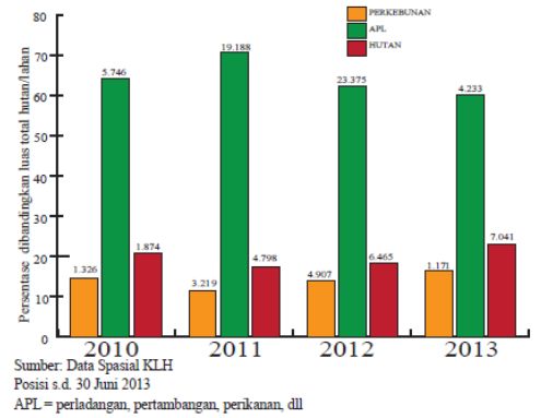
e above case is just a snapshot of the persistent problem of forest and land fires in Indonesia thathave
occurred almost every year in the last decade. e following shows the data on the development of hotspots
and forest and land fires that occurred in Indonesia from 2010 s.d. 2013. Forest and land fires are mostly
PDF generado a partir de XML-JATS4R por Redalyc
Proyecto académico sin fines de lucro, desarrollado bajo la iniciativa de acceso abierto 386SHOLIH MUADI. Smoke Haze Trigger Factors in the Malaysia Indonesian Border
caused by human behavior, whether intentional or as a result of their negligence. Only a small part is caused
by nature (lightning or volcanic lava).
Figure 3. Chart of Development of Hotspots on Land Allocation 2010-2013 (Qodriyatun: 2014)
Forests as part of national natural resources have an important meaning and role in various aspects of social
life, development, and the environment. It has been accepted as an international agreement that forests,
which have an important function for the life of the world, must be fostered and protected fromvarious
actions that result in loss of the balance of the world's ecosystems. However, there are actions by humans
who destroy forests, including through forest burning, which has recently become increasingly prevalent in
Indonesia. e causes of fire by humans can be detailed as follows (Qodriyatun: 2014):
1. Land conversion, which is caused by activities to prepare (burn) land for agriculture, industry,
construction of roads, bridges, buildings, and others;
2. Burning of vegetation, which is caused by deliberate but uncontrolled burning of vegetation
resulting infire jumping, for example, clearing of industrial plantations (HTI) and plantations, or
land preparation by the community;
3. Utilization of natural resources, which is caused by activities such as burning bushes and
cookingactivities by illegal loggers or fishing in the forest;
4. Utilization of peatland, which is caused by the activity of making canals or channels without
adequate control gates for water, causing the peat to become dry and flammable;
5. Land disputes, which are caused by attempts by local communities to regain their rights to land
or land
In fact, the socio-economic and ecological losses arising from forest fires are quite large; even in some
cases, it is difficult to measure them in terms of the rupiah value. Ecologically, forest fire incidents threaten
Indonesia's unique natural flora and fauna, perhaps even extinction. e loss that must be borne by the
Indonesian people due to the forest fires in 1997 was estimated at Rp. 5.96 trillion or about 70.1% of the
GDP value of the forestry sector in 1997. Malaysia, which was also affected by forest fires in Indonesia in
1997, suffered a loss of US $ 300 million in the industrial and tourism sectors, while Singapore suffered a
loss of around US $ 60 million in the tourism sector (UNDP: 1998).
In 2014 and 2015, there was an increase in forest burning in the Riau region. As a result of the forest fire,
it has created a large amount of haze, so that Riau was declared a Haze Disaster emergency. e thing that
PDF generado a partir de XML-JATS4R por Redalyc
Proyecto académico sin fines de lucro, desarrollado bajo la iniciativa de acceso abierto 387Utopía y Praxis Latinoamericana, 2021, vol. 26, núm. Esp.1, Marzo, ISSN: 1315-5216 2477-9555
is worrying is that if we look closely, from year to year, the forest fires that occur are actually increasing. For
the Riau region, for example, based on the latest NOAA 18 satellite observations, it is known that almost all
areas in Riau are experiencing forest and land fires, namely Bengkalis, Siak, Pelalawan, Indragiri Hilir (Inhil),
Indragiri Hulu, Rokan Hilir, and Meranti Islands Regencies.
e increase in CO2 concentration by 30 percent in the last 100 years has resulted in the earth's surface
temperature increasing between 0.3 - 0.6 ° C. is increase in temperature causes the ENSO (El- Nino
Southern Oscilation) phenomenon in Southeast Asia to occur more frequently and has an impact on
increasing the intensity of extreme rainfall events. Global climate change that has caused the prolonged
drought in Indonesia is one of the factors triggering land and forest fires. Basically, land and forest fires are
not natural disasters because 99% of incidents in Indonesia are caused by human factors, either deliberately
or negligently. Land and forest fires in Riau and almost all provinces in Indonesia in 2013 and 2015, whose
impact was in the form of haze to Singapore and Malaysia, have made this phenomenon a disaster that needs
serious handling. e vast area of land and forest that has been cleared in Indonesia to date is also influenced
by the biophysical characteristics of the land. Most of the fires in the last ten years have occurred on peatlands.
ese lands are naturally non-flammable wetlands, but if the peatlands are dry due to excessive drainage, they
are very susceptible to burning. Dry peatlands can also change in character so that they cannot return to their
original wetland form, resulting in a higher level of vulnerability to burning. us, the aspects of land and
climate conditions are important aspects that affect the incidence of land and forest fires (Fachrie: 2020, pp.
104-117).
e incidence of forest and land fires has become an environmental issue in the world, which has had
an adverse impact. e impacts of forest and land fires are multidimensional in nature, including social,
economic, environmental, and political impacts. An economic study of the impacts of forest and land fires
in 1997/1998 by Tacconi (2003) shows that these fires resulted in economic degradation and deforestation
of $1.62-2.67 billion, costs from the haze of $ 674-799 million and valuation of carbon emissions of 2.8
billion dollars. e social impact that is directly felt by the community is healthy, such as asthma, bronchitis,
ARI, to death, as well as the impact of job loss (Tacconi: 2003). For the environmental sector, the impact
due to land and forest fires is very large, namely damage to land use and haze that can exacerbate existing
climate change. Meanwhile, the political impact that arises from land and forest fires is smog pollution that
occurs across countries. ere have been many studies and cases that reveal that Indonesia is currently facing
major problems related to unsustainable forest management, which results in forest loss or deforestation.
is is partly due to poor forest governance that occurs linearly at all levels of government. Moreover, the
division of regions into new autonomous regions has made problems at the regional government level even
more complex.
Forest fires occur due to human or natural factors or climate change. e biggest causes of forest fires are
human actions and negligence. Some say that nearly 90% of forest fires are caused by humans, while 10% are
caused by nature. Forest fire prevention efforts are an effort to protect forests so that forest fires with negative
impacts do not spread. Forest and land fires have an impact on human life, both positive and negative.
However, negative impacts predominate which include: (1) emission of carbon gases into the atmosphere,
thereby increasing global warming; (2) loss of habitat for wildlife resulting in an imbalance of the ecosystem;
(3) loss of trees which are oxygen-producing and absorbing rainwater resulting in floods, landslides, and
drought; (4) loss of industrial raw materials which will affect the economy; (5) reduced forest area which will
affect the microclimate (weather tends to be hot); (6) smoke pollution, which interferes with community
activities and causes various respiratory diseases; and (7) decreasing the number of tourists. Riau's forest and
land fires have caused air quality to deteriorate. e Pekanbaru Health Office noted that the air in Pekanbaru
was at the level of 130 Psi (pounds per square inch) or unhealthy because it contains excess particulate matter
(PM-10), which is very dangerous for lung health. Even ten districts/cities in West Sumatra Province were
also affected by the Riau haze. is caused the Provincial Government to impose a haze emergency alert
PDF generado a partir de XML-JATS4R por Redalyc
Proyecto académico sin fines de lucro, desarrollado bajo la iniciativa de acceso abierto 388SHOLIH MUADI. Smoke Haze Trigger Factors in the Malaysia Indonesian Border
status until March 31, 2014. It was recorded that three thousand people were infected with acute respiratory
infections (ISPA) due to smoke. To mitigate the worse, some mayors/regents!! West Sumatra issued a policy
of dismissing school children (SD, TK, and PAUD). BNPB estimates that the economic loss due to forest and
land fires that occurred in Riau Province this year will reach IDR 10 trillion, starting from January to March
2014. Considering that the impact is very detrimental both materially and socially, efforts to combat forest
and land fires need serious attention from the government (Purnomo et al.: 2019, pp. 486-500; Qodriyatun,
2014).
Even though the government has issued regulations related to land clearing without burning the land and
forests, the incidence of forest fires caused by humans still frequently occurs. In July 2013, through satellite
imagery monitoring, there were 1,210 hotspots, of which 1,180 hotspots, or 98 percent of them were located
in Riau, Sumatra. is incident is likely to continue if law enforcement against the arsonists is still weak;
the determination of environmental compensation is oen not clear on the basis of calculations and is not
supported by calculation documents (JPNN, 2016). e results of research in 2011 showed that the law
enforcement efforts by the government, especially regarding land and forest fires, were still very weak. No one
has ever been arrested or advised for the arson offense. Papua and Kalimantan, which have the largest area
of forest cover, are very vulnerable to burning land to open new plantations. Forest fires due to land clearing
that can occur in Papua and Kalimantan are expected to continue as new plantations take place (Fachrie:
2020, pp. 104-117).
DISCUSSION
Actors Involved in the Haze Disaster
In an interview conducted with Syamsul Maarif, Maj. Gen. TNI-AD (Ret.) Prof. Dr., M.Si (Head of
BNPB 2008-2015) said:
"e forest fires that are happening right now are deliberately burned."(Interview, 19 June 2019 at
Sentul Bogor)Forest and land fires in Indonesia have caused haze disasters, harming both physically and
psychologically. In 2015, it was estimated to be the worst haze disaster Indonesia has ever experienced. And
there is no need to find out who can be blamed in cases of forest and land fires because the State, the Ministry,
and the Governor himself have given permission to burn land for clearing.
Land clearing by burning forests is permitted by the state, which is confirmed by Law Number 32
of 2009, which was signed by President Susilo Bambang Yudhoyono on October 3, 2009, concerning
Environmental Protection and Management. Article 69 paragraph (1) letter h states that clearing land by
burning is prohibited, but as long as the local community (local community) burns no more than two
hectares, firebreaks are made to prevent the fire from spreading. at's why clearing the land is justified and
protected by law. It is different if during the land clearing process there is a spate of fire which causes the area
of the burning to be more than two hectares, then the perpetrator of burning may be subject to punishment
in accordance with Article 108 in the form of imprisonment for at least 3 (three) years and a maximum of
10 (ten) years and a fine. At least Rp. ree billion and a maximum of Rp. 10 billion.
e Ministry of Environment and Forestry, through the Regulation of the State Minister for
theEnvironment Number 10 of 2010, on the mechanism for preventing environmental pollution and/or
damage related to fire and/or land, in article 4 paragraph (1) contains "Indigenous peoples who burn land
with a maximum land area of 2 (two) hectares per family head for planting local varieties must notify the
village head. " Although the burning must be notified to the village head and then the village head will notify
the agency that carries out government affairs in the field of district/city environmental protection and
management (paragraph 2), and it is not allowed to do it when the rainfall is below normal, drought, and
climate. Dry (paragraph 3), it is difficult to guarantee that the provisions in paragraphs 2 and 3 are carried
PDF generado a partir de XML-JATS4R por Redalyc
Proyecto académico sin fines de lucro, desarrollado bajo la iniciativa de acceso abierto 389Utopía y Praxis Latinoamericana, 2021, vol. 26, núm. Esp.1, Marzo, ISSN: 1315-5216 2477-9555
out properly because of the difficulty of conducting field supervision. If the law already allows clearing land
by burning, the regulations under it are only the details of what is meant in law.
Analysis of Haze Occurring During the Last 2 Years
In 2015, forest and land fires dragged on and had an impact on the environment and the national economy.
Forest fires seem to be a routine case that occurs every year at relatively the same time and place.
Table 1. Recapitulation of the Area of Forest Fires in Indonesia
Source: http://www.sipongi.menlhk.go.id
From the table above, it can be seen that from 2010 to 2014, the reactivity of forest fires increased, however
in 2015, the area of forest fires gradually decreased. e worst recapitulation occurred in South Sumatra,
followed by Riau in 2014. at means the government has a lot of domestic work related to forest fires,
which must be cleared immediately so that it does not become a continuing problem (Li et al.: 2017, pp.
24733-24742).
Political, Economic, and Cultural Influences in Haze Disaster
e losses due to forest and land fires are very large for human life and for the lives of other living things,
either directly or indirectly, among others (Hunawan: 2016):
1. Ecological Impact
Disturbing ecological processes, including natural succession, organic matter production and
decomposition processes, nutrient cycle, hydrological cycle, and soil formation. In addition, it
disturbs the function of forests as climate regulators and carbon sinks. It can further damage river
basins (DAS). Loss of biodiversity and ecosystems. Fires also release large amounts of carbon and
greenhouse gas emissions into the atmosphere, which exacerbate climate change.
2. Economic Impact
Loss of forest products (timber and non-timber). e disruption of economic activities from
the plantation, transportation, tourism, trade, and so on sectors. Medical expenses for health
problems and direct costs to extinguish fires.
3. Health Impact
Minor to acute respiratory distress. Smoke generated from fires contains a number of harmful
gases and particles such as sulfur dioxide (SO2), carbon monoxide (CO), formaldehyde, akrelin,
benzene, nitrogen oxides (NOx), and ozone (O3).
CONCLUSION
e conclusions that can be formulated from the research focus and related factors/aspects are:
PDF generado a partir de XML-JATS4R por Redalyc
Proyecto académico sin fines de lucro, desarrollado bajo la iniciativa de acceso abierto 390SHOLIH MUADI. Smoke Haze Trigger Factors in the Malaysia Indonesian Border
1. e Biggest Factor Triggering the Haze Disaster
Forest and land fires are mostly caused by human behavior, whether intentional or as a result of their
negligence. Only a small part is caused by nature (lightning or volcanic lava). Basically, land and forest fires are
not natural disasters because 99% of incidents in Indonesia are caused by human factors, either deliberately
or negligently. Law enforcement against the perpetrators of the arson is still weak; the determination of
environmental compensation is oen not clear on the basis of calculations and is not supported by calculation
documents
Actors Involved in the Haze Disaster e State, Ministry, and Governor have given permission to burn
land for clearing.
- Land clearing by burning forests is allowed by the state, which is confirmed by Law Number 32 theYear
2009, which was signed by President Susilo Bambang Yudhoyono on October 3, 2009.
- Ministry of Environment and Forestry through the State Minister of Environment Regulation Number
10 of 2010, concerning the mechanism for preventing environmental pollution and/or damage related to
fire and/or land
2. Analysis of the Haze that Occurred During the Last 2 Years From 2010 to 2014, the recapitulation
of the area of forest fires has increased, however in 2015 the area of forest fires has decreased. e
NationalDisaster Management Agency itself released in 2016 information on the number of exposures to
land and forest fires in the province, and the worst was Riau.
3. Political, Economic, and Cultural Influences in Haze Disaster
e losses due to forest and land fires are very large for human life and to the lives of other living creatures,
both directly and indirectly in the political, economic, and cultural sectors.
e conclusion provides an overview to answer the problems that occur in the real world. From the
conclusions, several recommendations can also be given that are directly related to the real conditions in the
field. ere are several recommendations given in research regarding the policy of handling haze disaster in
the border area between Indonesia and Malaysia, namely:
1. e need to improve the welfare together optimally at the Malaysia-Indonesia border. e
government's attention to border areas, especially infrastructure to smooth the flow of the
economy, so that the gap between the people living on the border is not too far behind, because,
at a certain point, the border area becomes the flow of goods exchange between the two countries.
2. Increasing cooperation between the two countries, Indonesia and Malaysia, in handling problems
at the border, as well as handling urgent events that involve the interests of the two countries,
namely in the scope, economy, social, culture, environment.’
BIODATA
Sholih Muadi: Was born in Blitar, on December 30, 1964. He is working as a lecturer at the Faculty of
Social Science and Political Science, University of Brawijaya. Undergraduate education pursued at Brawijaya
University majoring in Law graduated in 1988; then continued his master of Political Science at Gajah
Mada University, graduated in 1994 and a doctorate in the Sociology Law at the University of Diponegoro
Semarang. In addition to being a permanent lecturer at the Faculty of Social Science and Political Science,
Brawijaya University, he has worked as a dean at the Faculty of Social Science and Political Science, Brawijaya
University Period 2020 until now.
BIBLIOGRAPHY
ARLITASARI, W, (2017). " Indonesian policy to resolve the smoke haze disaster toward Malaysia".
PDF generado a partir de XML-JATS4R por Redalyc
Proyecto académico sin fines de lucro, desarrollado bajo la iniciativa de acceso abierto 391Utopía y Praxis Latinoamericana, 2021, vol. 26, núm. Esp.1, Marzo, ISSN: 1315-5216 2477-9555
ARNAKIM, L, & SHABRINA, N, (2019). "e role of Indonesia in managing trans-boundary haze
pollution asenvironmental security issue in Southeast Asia". e 1st Workshop on Multimedia Education,
Learning,Assessment and its Implementation in Game and Gamification in conjunction with COMDEV 2018.
BACHZAN, A, (2019). "Sengketa kebijakan pelabuhan johor malaysia dan singapura pada tahun 2018".Universitas
Islam Indonesia.
BASROWI, S, (2008). "Memahami penelitian kualitatif". Jakarta: Rineka Cipta, 12(1), pp. 128-215.
BENCANA, B, N, P, (2016). "RBI: Risiko Bencana Indonesia. badan nasional penanggulangan bencana".
BENCANA, B, N, P, (2017)." Data informasi bencana Indonesia (dibi)". Diakses dari http://bnpb. cloud/dibi/
laporan4.
CRESWELL, J, W, (2016). "Research design: pendekatan metode kualitatif, kuantitatif, dan campuran".Yogyakarta:
Pustaka Pelajar, 2(1), pp. 5-6.
FACHRIE, M, (2020)." Indonesia's forest fire and haze pollution: an analysis of human security". MJIR| Malaysian
Journal of International Relations, 8(1), pp. 104-117.
FITRIANY, S, (2017). "Indonesia and Malaysia's response towards transboundary haze pollution issue (1997-2006)".
president university.
FORSYTH, T, (2014). "Public concerns about transboundary haze: A comparison of Indonesia, Singapore, and
Malaysia". Global Environmental Change, 25, pp. 76-86.
HERMAWAN, I, (2019). "Metodologi penelitian pendidikan (Kualitatif, Kuantitatif dan Mixed Method)".
HUNAWAN, D, (2016). "Menyelesaikan Kebakaran Hutan dan Lahan (KARHUTLA) di Indonesia melalui “Jalan
Pantas” atau “Jalan Pintas” ". Seminar Nasional Hukum.
IDA, R, (2014)." Metode penelitian: Studi media dan kajian budaya". Kencana.
IHSAN, R, (2018). "Sengketa batas darat dan diplomasi perbatasan Indonesia terhadap Malaysia". Analisis CSIS,
47(4), pp. 553-568.
KARIM, M, F, (2019). "State transformation and cross-border regionalism in Indonesia’s periphery: contesting the
centre". ird World Quarterly, 40(8), pp. 1554-1570.
LI, C, WU, K, & WU, J, (2017). "A bibliometric analysis of research on haze during 2000–2016".Environmental
Science and Pollution Research, 24(32), pp. 24733-24742.
NOVITA, A, A, AWUMBILA, S, S, & BINTI NAZREY, S, N, (2020). "Transboundary Smoke-Haze Disaster
Mitigation Efforts". 2nd Annual International Conference on Business and Public Administration (AICoBPA
2019).
PURNOMO, H, OKARDA, B, SHANTIKO, B, ACHDIAWAN, R, DERMAWAN, A, KARTODIHARDJO,
H, &DEWAYANI, A, (2019). "Forest and land fires, toxic haze and local politics in Indonesia". International
Forestry Review, 21(4), pp. 486-500.
QODRIYATUN, S, N, (2014). "Kebijakan penanganan kebakaran hutan dan lahan". Pengolahan Data dan Informasi
(P3DI) Setjen DPR RI. Jakarta.
SURYANI, A, S, (2012)." Penanganan asap kabut akibat kebakaran hutan di wilayah perbatasan Indonesia".Aspirasi:
Jurnal Masalah-masalah Sosial, 3(1), pp. 59-75.
TACCONI, L, (2003). "Kebakaran hutan di Indonesia: penyebab, biaya dan implikasi kebijakan".
UNDP, K, (1998). "Laporan kebakaran hutan dan lahan di IndonesiaJilid l: dampak, faktor dan evaluasi".UNDP
KLH. Jakarta.
PDF generado a partir de XML-JATS4R por Redalyc
Proyecto académico sin fines de lucro, desarrollado bajo la iniciativa de acceso abierto 392You can also read