Indigenous Knowledge and Farmer Perceptions of Climate and Ecological Changes in the Bamenda Highlands of Cameroon: Insights from the Bui Plateau ...
←
→
Page content transcription
If your browser does not render page correctly, please read the page content below
climate
Article
Indigenous Knowledge and Farmer Perceptions of
Climate and Ecological Changes in the Bamenda
Highlands of Cameroon: Insights from the
Bui Plateau
Suiven John Paul Tume 1 , Jude Ndzifon Kimengsi 2,3, *        and Zephania Nji Fogwe 1
 1    Department of Geography and Planning, The University of Bamenda, P.O. Box 39 Bambili, Cameroon;
      wantume@gmail.com (S.J.P.T.); nfogwez@yahoo.co.uk (Z.N.F.)
 2    Department of Geography & Environmental Studies, Catholic University of Cameroon (CATUC),
      Bamenda P. O. Box 782 Bamenda, Cameroon
 3    Faculty of Environmental Sciences, Technische Universitat Dresden, 01737 Tharandt, Germany
 *    Correspondence: jude_ndzifon.kimengsi@tu-dresden.de

 Received: 24 October 2019; Accepted: 6 December 2019; Published: 8 December 2019

 Abstract: Anticipating seasonal and shorter time scale dynamics to farming practices is primordial
 for indigenous farmers’ resilience under extreme environmental conditions, where climate change
 is a menace to agro-hydro-ecological systems. This paper assesses the effectiveness of indigenous
 farmers’ knowledge and aptitude to read weather signs for informed decisions on their daily and
 seasonal activities. Such climate-proof development is anchored on indigenous people’s knowledge
 and perceptions in circumstances where the dearth of scientific evidence or information exists as
 in Cameroon. The study is based on eight focus group discussions and a survey of 597 farming
 households in seven agro-ecological basins on the Bui Plateau of the Bamenda Highlands. The results
 indicate that indigenous smallholder farmers value their ability to accurately observe and anticipate
 local conditions in various ways to serve their local realities more aptly than outside forecasts.
 Such local knowledge should thus exercise a complementary role weave in a local climate information
 understanding system that replicates ecological variability.

 Keywords: ethno-meteorology; farmers; indigenous knowledge

1. Introduction
      Climate variability and change affects the ability of rural communities to satisfy those needs that
are inherent to the environment [1–3]. Even though changes have been occurring over generations,
rural farmers have been adapting to these changes throughout their life using local environmental
knowledge [4,5]. The knowledge is relatively cheap, readily available to rural farmers, and it is a
climatically smart tool for sustainable development and the management of climate variability [6,7].
Environmental problems vary spatio-temporarily, but rural farmers, through continued experimentation,
trial and error, and sustained interactions with their local environment, have developed a vast local
knowledge about nature in their locale that they use in coping with and solving their problems, amongst
which are climate-related problems [8].
      UNESCO has a well-established program on preserving traditional knowledge, called Local and
Indigenous Knowledge Systems, LINKS. This program was one of the key pillars that contributed to the
framing of the Millennium Development Goals (MDGs) of poverty eradication and of environmental
sustainability. The same program has been expanded and incorporated in the Post-2015 Development
Agenda (Sustainable Development Goals-SDGs) to empower local and indigenous peoples in various

Climate 2019, 7, 138; doi:10.3390/cli7120138                                  www.mdpi.com/journal/climate
Climate 2019, 7, 138 2 of 18
aspects of environmental management by advocating and mobilizing their unique knowledge and
practices in climate change adaptation [9]. LINKS also contribute to safeguarding traditional knowledge
within indigenous communities by reinforcing intergenerational continuity through the development
of educational resources, based on local knowledge [10].
Indigenous knowledge is a cumulative and complex body of knowledge, practices, and
representations that are maintained and developed by peoples with extended histories of interactions
with the natural environment [11–14]. These systems are part of a complex that includes language,
attachment to place, spirituality, and perception of worldview [15]. Notwithstanding a variety of
terminology used to refer to local environmental knowledge (LEK), traditional ecological knowledge
(TEK), indigenous knowledge (IK), indigenous traditional knowledge (ITK), [16–21], all the terminology
has similar meanings and is used interchangeably to refer to the local environmental or traditional
knowledge and skills held by indigenous people, developed outside the formal scientific domain,
embedded in culture and steeped in tradition through oral tradition [22].
Climate change is any change in climate over time, whether due to natural variability or
because of human activity. According to a study by [23], climate change is attributed directly or
indirectly to human activity that alters the composition of the global atmosphere and which is in
addition to natural climate variability observed over comparable time periods. Indigenous farmers’
knowledge and perception of climate and ecological change is a function of traditions and customs,
handed to them from one generation to another. In the Bui Plateau of the Bamenda Highlands of
Cameroon, indigenous climate and ecological change perception are grounded on traditions and
culture, community priorities, needs, knowledge, and capacities, which enable local people to plan
and cope with the impact of environmental change in agriculture and other sectors. Perceptions of
these changes by rural communities are concentrated on observations of variations in temperature,
rainfall, and vegetation patterns, which are often backed by blending such perceptions with scientific
evidence [24]. Indigenous stakeholders of Bui Plateau in climate and environmental knowledge
systems include farmers, community elders, weather seers, and other gifted persons. They can study
and interpret weather signs to advise farmers to make informed choices on their agrarian practices.
Indigenous communities rely on their immediate environment for sustenance. Their environmental
knowledge systems are built through generations of living in close contact with nature [17]. Local
people often have knowledge of climatic conditions and extreme events going back generations and
have developed effective strategies for adaptation and resilience [25]. Such knowledge systems are
critical in informing local and national adaptation responses because conventional adaptation strategies
most often use top-bottom approaches which do not reflect grassroots realities. Not building on local
knowledge brings the risk of maladaptation and inappropriate responses [16]. Traditional ecological
knowledge must also be used in assessments, such as the Intergovernmental Panel on Climate Change
(IPCC), which remains a key influence on government policymaking [26–28]. This paper, therefore,
seeks to assess indigenous knowledge and farmers’ perception of climate and ecological changes as a
means to build on local sustainable environmental practice in the Bamenda Highlands of Cameroon.
2. Materials and Methods
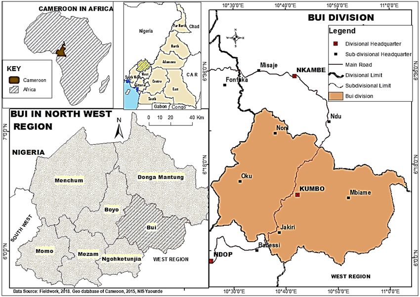
The Bui Plateau of the Bamenda Highlands of Cameroon is segmented into seven micro
agro-ecological zones that stretch between latitudes 6◦ 000 –6◦ 200 N and longitudes 10◦ 300 –10◦ 600 E.
Bui is an extension of the Western High Lava Plateau that diagonally cuts Cameroon from the Gulf
of Guinea along the tectonic axis called the Cameroon Volcanic Line (CVL). The study area offers
subsistent farmers with widely contrasting landscapes in the like of Mount Oku (3011 masl) and
Mbaw in the Tikar Plains (≈710 masl) that sustain diverse crops with varied agricultural calendars.
This hydro-morphological citadel is the watershed for Cameroons Western drainage basins for the
River Niger and Sanaga systems. It spans on an area of 2795 km2 (Figure 1), made up of six
administrative sub-divisions of Bui Division, namely, Kumbo (630 km2 ), Jakiri (675 km2 ), Nkum
(375.3 km2 ), Nkor–Noni (307.7 km2 ), Mbiame (575 km2 ), and Oku (232 km2 ).Climate 2019, 7, 138 3 of 18
Climate 2019, 7, x FOR PEER REVIEW 3 of 18
Figure 1. Location of the Bui Plateau.
The
The Bui
Bui Plateau
Plateau hashas two
two seasons
seasons (dry
(dry and
and wet). The dry
wet). The dry season
season lasts
lasts for
for four
four toto five
five months
months
(November–March) while the wet season lasts for eight months (March/April–October).
(November–March) while the wet season lasts for eight months (March/April–October). There is There is aa
general
general decrease in rainfall during the dry season, during which water resources shrink due to the
decrease in rainfall during the dry season, during which water resources shrink due to the
drying
drying out
out ofofintermittent
intermittentsprings
springsandanda adrop
drop ininthethewater
watertable.
table.This results
This to water
results to waterscarcity. The The
scarcity. dry
season is characterized
dry season is characterizedby dry byharmattan
dry harmattanwinds,winds,
whichwhichlack moisture and rather
lack moisture and facilitate the drying
rather facilitate the
out of the
drying outenvironment.
of the environment.
This
This is an analytical
is an analytical study
study that
that employed
employed the the cluster
cluster sample
sample survey
survey procedure
procedure to to data
data collection.
collection.
The choice of this design is because the research problem is multi–disciplinary
The choice of this design is because the research problem is multi–disciplinary with several with several stakeholders
involved
stakeholdersandinvolved
disciplines and affected by climate
disciplines affectedvulnerability and adaptation.
by climate vulnerability and The aspect of
adaptation. indigenous
The aspect of
adaptation to climate variability in the agrarian sector falls within the scope
indigenous adaptation to climate variability in the agrarian sector falls within the scope of cultural of cultural anthropology.
This design is This
anthropology. baseddesign
on a mixed
is based approach
on a mixed thatapproach
combinesthat quantitative and qualitative
combines quantitative andmethods
qualitative to
improve
methodson to the robustness
improve on theof the results. The
robustness study
of the is exploratory
results. The study in nature since it assesses
is exploratory in nature indigenous
since it
adaptations to climate variability vis-à-vis conventional adaptations.
assesses indigenous adaptations to climate variability vis-à-vis conventional adaptations. Qualitatively, information from
farmers pertaining
Qualitatively, to adaptations
information of rain-fed
from farmers agricultural
pertaining systems was
to adaptations ofobtained
rain-fed using a closed-ended
agricultural systems
questionnaire,
was obtained using focusa group discussions,
closed-ended expert interviews
questionnaire, focus group in key sectors involved
discussions, in climate
expert interviews in and
key
agriculture, as some key informants of community-based organizations
sectors involved in climate and agriculture, as some key informants of community-based involved in climate change
management
organizations for sustainable
involved rural livelihoods.
in climate The questionnaire
change management used a five-point
for sustainable Likert scaleThe
rural livelihoods. to
assess farmers’ indigenous climate knowledge (very high, high, very low,
questionnaire used a five-point Likert scale to assess farmers’ indigenous climate knowledge (very low, and unknown). Other
questionnaire
high, high, very items
low,contained close-endedOther
low, and unknown). questions on local sources
questionnaire of weatherclose-ended
items contained knowledge,questions
farmer’s
knowledge of weather
on local sources forecasting,
of weather perception
knowledge, about
farmer’s the natureof
knowledge of weather
local andforecasting,
scientific weather knowledge,
perception about
and perception of agro-ecological evolution in the Bui Plateau. Eight focus
the nature of local and scientific weather knowledge, and perception of agro-ecological evolution in group discussions (FDGs)
were conducted
the Bui Plateau. Eightto substantiate
focus group thediscussions
responses acquired
(FDGs) were usingconducted
questionnaires. The following
to substantiate groups:
the responses
Bongsiysi (Kishong),
acquired using Kongadzem
questionnaires. The(Kishong),
following Bongatati
groups: (Shisong),
Bongsiysi Mbokam
(Kishong),Mixed Farmers(Kishong),
Kongadzem Common
Initiative
BongatatiGroup
(Shisong),(CIG), Loweh Mixed
Mbokam Rice Farmers
Farmers CIG (Ber), Bongba
Common Mixed
Initiative Group Farming
(CIG),CIG
Loweh(Manchock-Oku),
Rice Farmers
Men
CIG of Vision
(Ber), CIG (Shisong),
Bongba and Momeyen
Mixed Farming Mixed Farming CIG
CIG (Manchock-Oku), Men (Nkor) participated
of Vision (Table 1). and
CIG (Shisong),
Momeyen Mixed Farming CIG (Nkor) participated (Table 1).Climate 2019, 7, 138 4 of 18
Table 1. Focus group discussions participants.
Groups Location Gender Type Number Activity Domain
Agriculture, weekly thrifts,
Bongsiysi Kishong Women 10
and loans
Agriculture, weekly thrifts,
Kongadzem Kishong Women 9
and loans
Soybean processing,
Bongatati Shisong Mixed 8
monthly thrifts, and loans
Men of Vision CIG Shisong Men 8 Livestock and Fisheries
Mbokam Mixed Cassava processing,
Mbokam Mixed 10
Farmers CIG weekly thrifts, and loans
Loweh Rice
Ber Mixed 9 Rice farming
Farmers CIG
Bongba Mixed Solanum potato
Manckock Mixed 8
Farming CIG production
Momeyen Mixed
Nkor Mixed 10 Maize production
Farming CIG
Total 8 72
Source: Fieldwork, August 2018.
The criteria of the selection of the groups was based on activities of rural farmers who rely solely
on indigenous knowledge systems to make informed choices on their activities. These included
farmers’ groups, associations, and cooperatives. Other group of discussions were with community
leaders and elders to explore local knowledge practices and applications throughout the agricultural
calendar. Women-only groups help develop women’s management capabilities more than joint groups
and having their groups enable women to act and gain self-esteem. Women-only groups are stricter
about resource regulation and enforcement than men-only or mixed-gender groups. Mixed groups
may inadvertently strengthen gender inequality by ignoring uneven power relations that translate
into a low social status and heavier workloads for women. Social inequalities found in mixed-gender
groups in which wealthier members usurp the benefits could be reproduced in women-only groups.
Women-only groups may also do less well in resource governance than mixed or men-only groups
because of laboor constraints faced by women, gender biases in technology access and dissemination,
and possible limits in women’s sanctioning authority. Evidence suggests that women-only groups
may have ecological benefits from stricter enforcement and in the short term may help in giving
women self-confidence, but in the long run, there is a risk that they may also reinforce existing gender
inequalities. These gender differentials greatly influence resilience to climate variability and change.
Community leaders who participated on discussions about indigenous environmental knowledge
systems were staff of Green Care Association, a local NGO based in Shisong, Fon (traditional chief)
of Taabah, Kingomen and Shufai Taansam, Takui. Guided interviews were conducted with some
traditional leaders to explore ways in which cultural and traditional practices enhance adaptation to
climate change. Other expert interviews were administered to the Divisional Delegation of Agriculture
and Rural Development (top-down approach). Questions were directed to rural farmers’ adaption to
climate variability and problems they face in the process. Some of the questions were on the number of
the agricultural basins and the specific activities and crops cultivated therein as well the agricultural
support programs that have directly supported rural farmers’ adaptation to climate variability and
poverty alleviation. The Bui Plateau is diverse and segmented into seven agrarian basins. Given that
the research problem revolves on the agrarian system, which is the life wire of the inhabitants of Bui,
the questionnaires (597, Table 2) were administered in clusters.Climate 2019, 7, 138 5 of 18
Table 2. Population of Bui Division and administration of questionnaires.
Questionnaires
Sub-Divisions Population Agrarian Basins Crops
Frequency %
Maize, cassava, beans, yams,
Kumbo 127,919 Nkar-Kumbo-Kikaikom 94 15.7
market gardening, solanum potato
Rice, maize, soya beans,
Jakiri 59,951 Mbokam-Ngomrin-Mbaw Nso 68 11.4
groundnuts, oil palm, cassava
Nkum 127,538 Dzeng-Tatum-Banten 91 15.2 Maize, beans, solanum potato
Nkor 63,487 Djottin-Nkor-Lassin 81 13.6 Groundnuts, maize, beans
Elak-Oku 144,800 Oku-Vekovi-Tadu 105 17.6 Solanum potato, maize, beans
Maize, cassava, beans, yams, cow
Mbiame 48,684 Mbiame 85 14.2 pea, groundnuts, solanum potato,
plantains
Maize, cassava, beans, yams, cow
Nkuv-Ndzeen 73 12.2
pea, groundnuts
Total 572,379 Total 597 100
Source: Fieldwork, August 2018.
The principle of cluster sampling solves the problem of data collection in a culturally and physically
diverse area. A convenient way in which a sample can be taken is to divide the area into smaller
overlapping areas and then to randomly select a number of these smaller areas (households located in
the agricultural basins), with the ultimate samples that are representative of the entire Bui Plateau.
In cluster sampling over the Bui Plateau, the target population were farmers in rural areas. These were
sub-divided into relatively smaller units relating to crops which are grown in specific areas. In cases
where more than one crop dominates in an agro-basin, double or multiple levels of clustering were
applied (multi-stage cluster sampling). The questionnaire was analyzed quantitatively in the Statistical
Package for Social Sciences (SPSS) Version 20 and Microsoft Excel 2013. Qualitative analysis entailed
recording of perceived agro-ecological changes during FDGs.
3. Results
3.1. Indigenous Knowledge Levels and Sources
Perception is the way of processing raw data that a person receives through his/her daily and
long-term interaction with immediate environment into meaningful pattern. Indigenous perception
depends not only on individual personality but also on community, environment, and interaction
among these components [29]. Before taking any further analysis of indigenous knowledge and farmer
perceptions of climate and ecological changes in the Bamenda Highlands of Cameroon, it was necessary
to assess
Climate 2019,the
7, xpeoples’
FOR PEERknowledge
REVIEW levels about climate change (Figure 2). 6 of 18
61.0
54.8
51.0
41.0
32.2
31.0
Percentage
21.0
11.0 5.5
4.5 3.0
1.0
Very high High Very low Low Unknown
Knowledge level
Figure 2.
Figure Levels of
2. Levels of indigenous
indigenous climate
climate knowledge.
knowledge. Source:
Source: Fieldwork,
Fieldwork,August
August2018.
2018.
One-third (32.2%) of farmers have very high knowledge of climate change, 54.8% have high
knowledge, 4.5% have very low, 5.5% have low, and only 3% have no knowledge. Sources of
indigenous weather activities on the Bui Plateau are through plant behavior (49.4%), personal
intuitive perception (18.9%), animal behavior (12.2%), consultation of traditional weather seersClimate 2019, 7, 138 6 of 18
One-third (32.2%) of farmers have very high knowledge of climate change, 54.8% have high
knowledge, 4.5% have very low, 5.5% have low, and only 3% have no knowledge. Sources of indigenous
weather activities on the Bui Plateau are through plant behavior (49.4%), personal intuitive perception
(18.9%), animal behavior (12.2%), consultation of traditional weather seers (4.7%), stream behavior
(6%), and consultation of community elders (3.7%) (Table 3).
Table 3. Sources of weather knowledge in the Bui Plateau.
Conventional
Frequency % Traditional Sources Frequency %
Sources
Meteorological
10 1.7 Animal behavior 73 12.2
service
TV 5 0.8 Plant behavior 298 49.9
Radio 9 1.5 Personal perception 113 18.9
No weather information 3 0.5
Weather seers 28 4.7
Elders 22 3.7
Stream behavior 36 6
Source: Fieldwork, August 2018.
A small proportion of inhabitants of the population of the Bui Plateau uses conventional sources
such as television, (0.8%), meteorological services (1.7%), radio (1.5%), and those who do not have any
weather information (0.5%). The dominance of indigenous sources of weather activities is because
most farming communities do not have access to electricity, which deprives them of gadgets like
televisions and other electronic devices. Typical farmers in frontier basins like Lassin, Mbaw Nso,
Nkuv, Gwarkang, Mbokam, Njanawa use mainly simple phones (for those who can afford) that can be
charged with a small solar panel. This partly accounts why such farmers resort more to indigenous
sources of weather activities than scientific weather information. Furthermore, indigenous farmers
reported at about 47% that the language of conventional weather forecasting is too complicated and
hard for them to comprehend. They also asserted that the situation is made worse by the absence of
local weather scientists (37%) to teach them weather changes for agricultural planning. The farmers
also perceived that scientific weather reporting is faulty (9%), and hardly corresponds to the observed
realities and communicates irregularly (7%). With these limitations of conventional weather sources,
Bui farmers rely on community elders (45%), personal weather predictions (27%), local weather seers
(24%), and friends and neighbors (3%).
Community elders and local weather seers often invoke the gods of the rain through periodical
incantations and traditional sacrifices. In Nso land, such traditional sacrifices are performed at the
beginning of the planting season, where the gods are invoked for a good agricultural season, before
the start of first weeding, harvest, and at the start of the farming season. The first sacrifice to invoke
the gods of the land is performed by His Royal Highness the Fon of Nso. This is done at five shrines
located at the palace in Kumbo, Mantum in Jakiri, the Kinsaan plunge pool in Kitiwum, the Mairin
plunge pool in Takui, and the palace in Kovifem. After the fon’s performance, other traditional leaders
do the same in their respective areas of jurisdiction. Such sacrifices entail pouring libation (palm
wine), pronouncing incantations and slaughtering goats and chickens, where their blood is sprinkled
as sacrifice. The slaughtered chickens or goats are not edible by the indigenes or any other person.
The carcasses are allowed in the open air to be devoured by vultures. Indigenous and local practices
(ILP) are the result of the application of culture, context and location-specific knowledge to solve local
problems. The close relationship of indigenous peoples with their environment makes them vulnerable
to the effects of global warming. Indigenous people tend to live in worst places hit by the impacts of
environmental change and their poverty exacerbates vulnerability [5].Climate 2019, 7, 138 7 of 18
3.2. Community Knowledge for Agrarian Weather Forecasting
Community knowledge of weather forecasting is an important component of the concept of
ethno-meteorology. It is based on traditional ecological knowledge handed down from generation
to generation [16]. Several variables were chosen in this study to express indigenous community
knowledge for planning in the agro-hydrological systems of the Bui Plateau (Table 4).
Table 4. Farmers’ knowledge of weather forecasting.
Variables Freq %
Personal experience 431 72.2
Mere smells 307 51.4
Sounds of birds and insects 440 73.7
Make necessary decisions to overcome any weather problem as
306 51.3
required and deemed fit
Through certain plants 296 49.6
Forefathers from whom farming experience was acquired 422 70.7
Through the gathering of clouds 570 95.5
Pattern of first rains in a farming year 332 55.6
Through certain signs, discern whether there will be excess or scarce
250 41.9
rains in a given farming year
Through star constellation, predict whether it will rain or not 217 60
From personal experience, predict the extreme of temperatures in a
334 55.9
given farming year
Using trend observation/ sequence of yearly weather events, determine
256 42.9
what the climate would be in a farming season
Source: Fieldwork, August 2018.
The choice of this is because conventional weather information systems are absent, with only five
functional stations on the Bui Plateau (Tatum, Takui, Kumbo, Jakiri, and Mbaw Nso). With increasing
variability in climate and uncertainty of first rains, most decisions made by indigenous farmers on the
Bui Plateau are based on personal experience and conviction (72.2%). As risky as such decisions at the
beginning of the planting may be, farmers perceive that the behavior of rains at the onset of the wet
season gives them a clue as to how the rest of the growing season will unfold. Erratic nature of rainfall
can cause misinformation and mislead farmers to make wrong decisions, given that the dry season is
already gradually prolonged. Some signs such are mere smells (51.4%) that indigenous communities
rely on to predict whether it going to rain or not at a time is still en vogue.
Some people are gifted to predict the onset of first rains through weather smells, especially in
the mornings of the months of February, March, and April. The sounds of some birds and insects is a
common indigenous weather forecasting tool in many communities of the Bui Plateau (73.7%). One of
such birds is the Senegalese Cowcow, which sings in the morning or anytime of the day to announce
rains in about the next 10 to 60 min. On the other hand, the chattering of the Cameroon Mountain
Francolin indicates good weather. Insects like crickets cackling at night is an indicator that there will
be no rain. Another visible indicator of cessation of the wet season is swarms of dragon flies that fly
eastwards from October to November. In the absence of conventional weather forecasting, farmers in
the Bui Plateau are able to read weather signs through the behavior of some plants (49.6%). One of
such plants is Scadaxus multifluros, which blossoms only once in a year in late February to early March.
This plant has been used for generations in Kumbo-Jakiri-Wainamah, Nkum and Oku agrarian basins
to read the weather about the onset of the first rains. Once it blooms, the rainy season will begin inClimate 2019, 7, 138 8 of 18
about three weeks to one month. A farmer in Shisong affirmed that reading weather signs through the
behavior of plants and animals was handed to him by his great grandfather. Indigenous knowledge
handed down by forefathers from whom they acquired farming experience have had long standing
and proven experience of weather forecast from which they have benefitted. From such experiences,
farmers predict rainfall patterns through the farming season. During the dry season, indigenous
communities of the Bui Plateau also study the yellowish-reddish atmospheric aerosol loading to make
informed decisions about their farming activities.
Aerosol coloring of the atmosphere occurs mainly from December till the start of the wet season.
This coloring indicates the appropriate time for farmers to start raising ‘ankara’ on farms. In the
Dzeng-Tatum-Banten basin, raising ankara (a form of slash and burn) is through the burying of maize
stalks for burning. In Mbam valley, ankara is practiced in newly opened fields and in old fields. Bush
burning for agricultural activities, pasture regeneration, dry season dust storms are the main sources
of local aerosol loading into the atmosphere on the Bui Plateau during the dry season. As from the
month of February rain clouds (cumulo-nimbus) start building. Through the gathering of clouds
(95.5%) such as a small alto-cumulus and strato-cumulus, community elders, weather seers, and people
with experience in reading weather signs can predict the approximate date that the wet season will
begin. Other indicators of indigenous weather forecasting include star constellation (60%), extreme
temperatures (55.9%) and sequence of yearly weather events to determine what the climate would
be in a farming season (42.9%). Dark clouds, according to indigenes signify approaching heavy rain.
Ethno-meteorology is a mystery and only some members of the community are gifted in reading and
interpreting cloud patterns [30–32]. Some of the predictions of ‘cloud watchers’ often miss out and can
be very misleading because of changing climatic and environmental conditions. In the Bui Plateau,
weather seers are mostly old men of more than 50 years of age who have been practicing agriculture all
their life.
3.3. Local and Scientific Weather Knowledge in Agrarian Practices
A local farmer’s ability to make informed decisions is largely governed by personal experiences
acquired over the years. In the absence of credible scientific weather information systems to farmers,
they must resort to what is at their disposal. Even when scientific weather systems are broadcast on
the media, it appears hard to be understood by rural farmers because of low levels of formal education
(Table 5). Daily weather forecast broadcast by the Cameroon Radio Television (CRTV), Spectrum
Television (STV), and Equinox TV are faulty. Local weather knowledge is simple to understand than
conventional scientific knowledge. Both local and scientific knowledge in weather forecasting over the
years are produced through observation, experimentation, and validation.
Scientific knowledge in weather reading follows certain procedures in its production process, but
local knowledge is unregulated and haphazard or unorganized by oral tradition. Local knowledge in
weather prediction does not require sophisticated tools. Formal education or training is not needed to
acquire skills in local weather forecasting. Exercising local knowledge in weather prediction requires no
financial investments. Despite yawning differences, scientific weather forecasting and local predictions
are mutually exclusive. Local approaches to weather prediction is often accurate and as such are the
best in making the right decisions in farming activities. Whereas scientific weather forecasting is purely
secular, local knowledge in weather reading entails a great measure of spirituality. Indigenous peoples
are among the first to face the direct consequences of climate change due to their dependence on and
close relationship with the environment and its resources [33].
Traditional environmental knowledge has an advantage of being directly linked to household
daily activities. It is concerned with the immediate necessities of people’s daily livelihoods and can
provide a short-term and immediate solution to a means of survival in the community, making it
meaningful [4,34]. It may also be useful under transitory conditions, as opposed to contemporary
science developed through research and principles for solving global problems without a local origin
nor link to social, cultural, political, and physical environment of a specific local area and removed fromClimate 2019, 7, 138 9 of 18
the daily lives of the people [18]. Researchers have acknowledged the dynamism of local knowledge
in providing solutions and coping with new environmental and economic hardships in society [20,35],
with further acknowledgement that some local farmers have succeeded in their farming systems by
combining local farming methods with scientific knowledge [36,37].
Table 5. Farmers’ perception about the nature of local and scientific weather knowledge.
Local Scientific Undecided
Variables
% % %
Scientific weather forecast cannot be relied upon as it
56.6 23.8 19.6
does fail most of the time
Local knowledge, is simple to understand in weather
prediction, the same cannot be said of scientific 72.5 17.8 9.7
knowledge
Both local & scientific knowledge in weather
forecasting are over the years produced through 81.4 9.2 9.4
observation, experimentation & validation
Scientific knowledge in weather reading follows
certain procedures in its production process, local
74 15 11.7
knowledge is unregulated and haphazard or
unorganized
Local knowledge in weather prediction does not
75 13 11.2
require the use of sophisticated tools
Formal education or training is not needed to acquire
70 10 20.1
skills in local weather forecasting
Wielding local knowledge in weather prediction
65 17 17.1
requires no financial investments
Scientific weather forecasting and local predictions
58 29 12.9
are mutually exclusive
Local approaches to weather prediction is always
accurate & as such are the best in making the right 62 27 10.4
decisions in farming activities
Local knowledge in weather reading entails a great
52 35 12.7
measure of spirituality
Scientific approach to weather forecasting should
only be supplementary to local approach in making 53 27 19.9
farming decisions
Source: Fieldwork, August 2018.
Scientific approach to weather forecasting should only be supplementary to local approach in
making farming decisions. Scientific analysis of climatic data and indigenous perceptions recorded
in this study shows some convergences. There are problems that hinder the synergies of indigenous
traditional local knowledge with contemporary science in the management of resources, such as
differences in power relations between developed and developing countries. This is aggravated
by limited integration techniques which are exacerbated by the lack of proper background in local
knowledge, lack of realization that indigenous traditional knowledge has values attached to local
content touching the life of the local people and could contribute to the development of sustainable
climate change, mitigation, and adaptation strategies and lack of proper understanding on how local
knowledge could be used in dealing with environmental issues hence solutions to developmental
problems [37,38]. Despite the positive features of indigenous traditional knowledge, there are doubts
that question the legitimacy of the knowledge in managing agriculture, while many farmers stillClimate 2019, 7, 138 10 of 18
suffer from food shortages and increased environmental degradation [13]. There are other factors
that are embedded in food production that farmers encounter such as imported food, abrupt and
prolonged occurrence of natural hazards such as floods, drought, and windstorms that most rural
farmers are not able to cope with [20,39], as well as the misguided notion that all indigenous practices
are unproblematic and would be a panacea to all small-scale farming and nature related environmental
problems because they are local in origin [40].
3.4. Agro-Hydro-Ecological Indicators of Climate Variability in Bui
The relationship of humans with the Earth’s environment has changed throughout the evolution
of Homo sapiens and the development of societies [41,42]. Apart from climate change, the environment
at the local scale of Bui Plateau has witnessed changes in weather conditions, the ebbing of streams and
shrinking water resources, loss of rich tropical montane forests, land degradation from overgrazing, and
accelerated erosion on arable land. These dramatic changes are within the framework of ‘anthropisation’
given that man has become a robust geophysical agent during the Anthropocene Era [43,44]. The impact
of human activity in the Bui Plateau has perturbed the delicate steady state of nature. This has greatly
reduced the resilience of livelihood and life support systems. From 1970–1979, the agrarian system
in the Nkar-Kumbo-Kikaikom basin was characterized by flat ridging, high coffee prices, massive
deforestation to establish new farmlands, and planting of eucalyptus (Table 6).
Table 6. Farmers’ perception of agro-ecological evolution in the Bui Plateau.
Period Agro Activity Weather Traits Hydrological Responses Remarks
Flat ridging, high yields,
massive deforestation, high
Regular onset of first Unperceived
1970–1979 coffee prices, planting of Abundant water resources
rains in mid-March changes
eucalyptus, long fallow
periods,
Decline in coffee prices,
massive deforestation,
emergence of large-scale Regular onset of first Abundant water resources,
eucalyptus plantations, rains in mid-March, stable water resources, but
1980–1989 Moderate changes
massive elimination of coffee severe droughts noticeable drops in some
farms in the mid-1980s due (extreme weather events) head springs & streams
to slump of prices at world
market
Shrinking local springs and
Fallow periodsClimate 2019, 7, 138 11 of 18
changes in water resources. The drought of early and mid-1980 caused minor environmental changes
like drops in crop production.
From 1990, there were already remarkable drops in food production, which initiated the advent of
chemical fertilizers application. The onset of first rains became irregular and extreme weather events
like dry spells, stormy weather, and floods increased. In July 1998, hail stones destroyed crops and
over the Bui Plateau. Water levels dropped remarkably in local streams. The inhabitants could already
perceive that their livelihoods were vulnerable to changing environmental conditions. The Strategic
Humanitarian Services (SHUMAS) initiated the eucalyptus replacement project to save watersheds
from the overwhelming effects of eucalyptus plantations. From 2000, reasonable food crop production
for maize could only be boosted by application of chemical fertilizers. Temperatures plunged and the
onset of first rains became very irregular. Mounting water scarcity became a daily reality, leading to
the emergence of water scarcity problems. [45,46] affirmed that rapid urbanization and poor water
governance are threats to water security in Kumbo town. From 2010, an innovation in the agricultural
sector was the increased use of herbicides (spray weeding). Pests like caterpillar invasions also became
regular during the early growing seasons. The 1970s, in the Nkum basin, were characterized by long
fallow periods, low population growth, and thick natural forest from Nkum Kov to Banten.
Other pockets of natural forest cover are at Kov Mven, Kovifem and Takui. Rainfall was
regular with onset of first rains in mid-March. Like Nkar-Kumbo-Kikaikom basin, water resources
were abundant, and people could hardly perceive any environmental changes. The 1980s were
characterized by massive deforestation and the emergence of large-scale eucalyptus plantation all
over the landscape (watersheds, fertile lowland plains). With the slumping of coffee prices at the
world market and the closure of the West Cameroon Marketing Board, farmers, transformed coffee
farms into cultivable land and eucalyptus plantations. The emergence of eucalyptus plantations at
head waters caused noticeable drops in spring yields in the late 1980s, thereby leading to vulnerability
of water resources to environmental change. With increasing population, fallow periods dropped
significantly, necessitating the use of chemical fertilizers to boost crop output. The onset of first rains
became irregular, characterized by frequent dry spells and stormy weather, leading to a drop in water
levels in streams. To address degradation of watersheds, SHUMAS embarked on the eucalyptus
replacement project, through cutting down of eucalyptus and replacing with eco-friendly species like
maesopsis, pronus, polysia, vitex, and cordia. Between 1996 and 2005, over six million environmentally
friendly trees have been planted in Bui and Donga Mantung Divisions through SHUMAS’ eucalyptus
replacement project. Recent weather patterns and a changing climate have led to severe water scarcity
and vulnerability of livelihoods system to environmental changes. Tatum, the headquarters of Nkum
Sub-Division is reputed for water shortages all since 1980s.
The Nkuv-Ndzeen agrarian basin is one of the areas of drastic anthropisation in the Bui Plateau.
In the 1970s, this frontier zone was characterized by thick cover of tropical savannah transition forest,
with a normal seasonal hollow frontier and transhumance phenomenon. Like in the other basins,
rainfall was regular with the onset of first rains in mid-March. There were relatively clean natural
streams. The environment was relatively stable. In the 1980s, the basin was transformed into a
sedentary frontier (a new permanent farming area). Rainfall was still regular with the onset of first rain
in mid-March; though there were signs of extreme weather events such as the droughts of 1983–1984.
With increasing anthropisation, there was massive deforestation, accelerated erosion in agricultural land,
which led to sedimentation of water bodies. In the 1990s, intensive agriculture and grazing caused
massive forest loss, leading to a decline of water resources indicating high vulnerability of human and
environmental systems. From 2000–2009, this area became a sedentary basin for agro-pastoral activities,
characterized by frequent cultivator-grazier conflicts, which have been persisting. The persistence
of cultivator-grazier conflicts is because these activities are not compatible in the same area. Severe
land degradation has transformed the landscape into desert-like conditions leading to complete loss of
surface vegetation and the development of bad lands. Between 2010 and 2018, frontier settlementsClimate 2019, 7, 138 12 of 18
like Nkuv, Bamkov, Ndzeen, and Gwarkang suffered from fuel-wood crisis, water scarcity and highly
susceptible to landslides, prolonged dry seasons, and a host of other environmental stressors.
The Mbokam-Ngomrin-Mbaw Nso area was traditionally a hollow frontier like the Nkuv-Ndzeen
basin. In the 1970s, regular onset of first rains and stable environmental conditions were the norms.
In the 1980s, the area was transformed into a sedentary basin in the same vein as Nkuv-Ndzeen.
The drought of the early to mid-1980s led to disturbances of the natural state of the environment with
shrinking of water resources. With the low-lying nature of this area, rice culture was experimented in the
1990s, which became an additional agrarian practice. Irregular onset of the first rains continued, leading
to frequent cultivator-grazier conflicts. Water resources continued to shrink, leading to vulnerability
of agrarian systems to climate variability and change. From 2000, there has been decreasing drop in
maize and beans cultivation. Cultivator-grazier conflicts have also intensified. Flooding and other
environmental stressors have increased leading to high vulnerability of agro-hydrological systems to
changing environmental conditions.
The Djottin-Nkor-Lasin plain located north-west of the Bui Plateau is an eastern extension of
the Donga-Plain. In the 1970s, there was abundant crop output, lush tropical highland forest cover,
regular onset of first rains in March, and overflowing springs and springs. Like the Nkum area,
there was massive elimination of coffee farms in the 1980s due to slumping of the coffee prices at
the world market. The drought of the early to mid-1980s caused people to know that environmental
changes were occurring. When food crop started dwindling in the 1990s, farmers resorted to the use of
chemical fertilizers. The Bamti area also attracted graziers. As a result, Bamti has become one of the
hotspots for cultivator-grazier conflicts. From 2010, uncertainty of weather patterns became regular.
The inhabitants also faced water shortages as an indicator of climatic and environmental stressors.
The Oku-Vekovi-Tadu basin is a highland agrarian basin. In the 1970s, the area was covered by
thick montane forest of the Kilum Ijim. Agricultural output was abundant. There was regular onset
of first rains at mid-March, with high yielding springs and a relatively stable environment. In the
1980s, there was massive deforestation of the Kilum-Ijim forest due to population increase and the
need for increased food production; the destruction of springs and disturbance of the natural state
of the environment. In the late 1980s, conservation measures were put in place and enforced by
legislation. A few community forests were created around the Kilum-Ijim like Ijim, Upper Shinga,
Mawes, Kedjin, Emfeh-Mii, Nchiy, Mbai, and Bihkov (Vekovi). There is also a plant life sanctuary
in Elak-Oku. Despite these measures, water crisis has become the order of the day in Oku because
of population growth, ailing infrastructure, climate and other environmental changes. Population
increase has been progressive in Oku against a backdrop of declining resource base.
The Mbiame agro-ecological basin has witnessed its own share of agro-hydrological changes
since the 1970s. The 1970s were characterized by stable conditions through abundant overflowing
streams, regular onset of first rains in mid-March, abundant crops output, longer fallow periods,
shifting cultivation, and large expanses of tropical highland forest like the Mbiame forest. Changing
environmental conditions in the early to the mid-1980s like droughts and the slumping of coffee prices
pushed farmers into the Mbiame forest to open new farmlands. Despite this, there were no discernible
changes in water resources. By the 1990s, agricultural output was already dropping, and farmers
embraced the application of chemical fertilizers to boost production. The Mbiame forest continued
to vanish, while farmers were experiencing high temperature and irregular onset of the first rains.
With increasing threats of climate change and environmental degradation, some NGOs like the Centre
for Nursery Development and Eru Propagation (CENDEP) and Green Care Association (GCA) stepped
in to restore the Mbiame forest through soil and water conservation.
A common trait in all the basins is that the local agro-hydrological system has changed over
time, though the indigenes of the Bui Plateau perceive mostly negative changes. Farmers perceived
that the 1970s were characterized by flat ridging, regular onset of first rains in mid-March, massive
deforestation, high coffee prices, planting of eucalyptus, severe droughts (extreme weather events)
and abundant water resources. Agricultural intensification has brought major environmental changesClimate 2019, 7, 138 13 of 18
on the Bui Plateau. Kishong village, for example is known to have been carpeted with natural forest
up till the 1970’s. With increasing population and the need to feed and accommodate the additional
mouths, these forested areas were transformed into farmlands. In Kumbo central, there has been
rapid population growth. Within the Kumbo urban space, there is land use competition for functions
such as residential, commercial, and agricultural. This often leads to conflicting interests, thereby
creating environmental problems within the urban space [47]. Some fallowed pieces of land are now
occupied by eucalyptus. Along the Kuvlu-Banten range, there has been rapid deforestation, thereby
turning natural forests into savannahs. These changes increase the vulnerability of agro-hydrological
systems and weaken adaptive capacities. These systems interact with each other, so there is need to
maintain them all to underpin human well-being. Global impacts and associated risks to humans
are already evident for climate change, biosphere integrity, biogeochemical flows and land-system
change. By 2012, the equivalent of 1.6 Earths was needed to provide the natural resources and services
humanity consumed in one year [48]. Rapid and unsustainable cultivation has also intruded into
natural forest patches around the Kovifem Fon’s Palace, Kifem, Takui, Mount Oku, Mbiame, Nkuv,
Kov Ndzeen, and montane forest communities of Nkum-Kov. Another agricultural practice is human
intrusion in wetlands along stream flood plains. Along the Mairin valley, stretching from Mbimtsen are
artificial levees constructed about 1 m high and 1 m in width to contain floodwaters from destroying
crops during the rainy season. In some places like Takui, Kaiy, Kishong, some stream channels have
been straightened and even diverted to cultivate vegetables and solanum potato during the dry season.
These practices are also feasible in the Mbim valley at Ngondzen and Nseh.
4. Discussion
Indigenous environmental knowledge on the Bui Plateau is plagued by several factors. Some
of these include the lack of government assistance, gender sensitivity, unreliability, changing
environmental conditions, and inapplicable nature of indigenous knowledge in all aspects of daily
life. Indigenous environmental knowledge is also threatened its reliance on local beliefs and taboos
and difficulties to apply when some critical decisions must be made in the agrarian cycle [49,50].
Of these factors plaguing indigenous environmental knowledge practices on the Bui Plateau, the lack of
government assistance appears most outstanding. The farmers perceive that the government does not
promote indigenous environmental practices. It is also perceived that traditional ecological knowledge
is known only by a few community members (elders, weather seers, and gifted persons). Changing
environmental conditions are also threatening local farmers’ knowledge because they are no longer
accurate in predicting weather condition as in the past. Climate change exacerbates the difficulties
already faced by vulnerable indigenous communities, such as political and economic marginalization,
loss of land and resources, discrimination, and unemployment [33]. Climate change disrupts seasonal
cycles of activities like agriculture, prolongs the dry season, reduces precipitation, and dries up water
sources [51,52]. These changes impact on indigenous activities due to loss of seeds, bad harvests,
livestock mortality, emergence of new insect pests, thereby threatening local food, and water security.
According to [53], the major threats of changing climate are erratic rainfall and rising air
temperature. The intensity of rainfall has reduced, and the number of rainy days has declined leading
to a decline in crop production and offsets in other ecological systems. In rural areas, farmers must
sow seeds in advance. Since the crops’ growth period is shortened and growing speed is accelerated,
indigenes can no longer follow their tradition to plant and harvest crops like before [54,55]. The onset
of the wet season in 2018, for instance, ‘confused’ the weather seers. While some advised farmers
to sow their crops, others were reticent and convinced that the rains had really started. Those who,
however, sowed early enough had abundant harvests, while those who sowed late had very poor
harvests. Despite the successful and the widely recognized role of local environmental knowledge in
managing natural resources and agricultural production under climate variability and change over
generations [56], the knowledge faces challenges as a panacea to some climatic and other environmental
related problems [57]. The knowledge is blamed being vague and unsatisfactory by failing to boostClimate 2019, 7, 138 14 of 18
food production and economic transformation in Africa [58]. This may result in the knowledge being
pushed to the margin of development practices in a very near future [59]. To some extent rural
farmers are responsible in making local environmental knowledge unsuccessful. [18] argued that local
knowledge lacks support from development practitioners and even households themselves may have
little confidence in their own knowledge that might provide a solution to their environmental problems,
even though it has done so for over generations. This makes local knowledge gradually disappear in
most African countries without any tangible efforts to recognize or manage it [60].
Local knowledge is preserved in the memories of elders which means it gradually disappears due
to memory lapses and deaths due to the fact that most of the indigenous practices are handed down
orally or by demonstration from generation to generation and when those owning the knowledge die,
or refuse to pass it to another generation, the knowledge undergoes extinction [61]. This is because
most of the knowledge has not been captured, documented, recorded, and stored in a systematic
way [62]. This is reflected in the African adage that ‘when a knowledgeable old person dies, it is a
whole library that disappears’. [9] pointed out resolutions to preserve indigenous knowledge as foot
prints that may provide paths to future analysis and appreciation of the knowledge and wisdom that
sustained local African cultures over time. It is being rapidly eroded by the absence of independent,
codified records of the orally transmitted past by traditional community chroniclers, as opposed to
formal knowledge which is successful due to its open systems with formal structures and rules to
which members of organizations adhere [63]. Similarly, the way the local knowledge is transmitted,
accessed, and shared in the society is not smooth but rather fragmented due to various factors such as
age, gender, status, wealth, and political influence, as well as attitude, perceptions, norms, values, and
belief systems inherited by the communities [64]. The knowledge is also threatened by the processes of
urbanization and growth of towns into cities, which attract more migrants from African rural areas into
cities and towns, hence limiting constant refreshment, transmission and or appropriate modification of
indigenous knowledge [65].
Much traditional knowledge is no longer transmitted to the youth as the society becomes more
involved in the market economy replacing locally used crops and plants by cultivated or market-based
consumer goods [66]. Most societies owning local knowledge in Africa were once colonized [67],
hence the influence of colonialism and colonial economy, which devalued all belief systems and
local ways of knowing through the attribution of such descriptors as ‘pagan, savage, and ungodly’.
Rationalization of various processes for ‘civilizing the conquered natives’, contributed to the loss of
important traditional values that cannot be restored. Indigenous knowledge systems have become a
field of interest since communities are generally under threat from the new economic systems that
continue to undermine their livelihoods, belief systems, value and interests.
5. Conclusions
The trend of weaknesses of indigenous climate and environmental knowledge on the Bui Plateau
is decreasing as the government does not promote indigenous environmental practices. Traditional
ecological knowledge is in the hands of a few community members (elders, weather seers, and gifted
persons). Climate change would thus continue to disrupt seasonal cycles of activities like agriculture,
prolongs the dry season, reduces precipitation, and dries up water sources. Local knowledge that
is preserved in the memories of elders is gradually disappearing due to memory lapses and deaths
creating indigenous knowledge extinction. The knowledge is also threatened by the processes of
urbanization and growth of towns which attract more migrants from rural areas hence limiting constant
refreshment, transmission, and/or appropriate modification of indigenous knowledge. Through
indigenous environmental knowledge, Bui farmers have been able to identify changes occurring in
their environment and plan their social and communal activities, such as planting, harvesting, and
hunting, in response to changes in weather and climate in different seasons of the year, making
informed environmental decisions for their survival through exploiting their natural resource base over
generations, in spite of the variations occurring due to climate change. Current climatic conditions appearClimate 2019, 7, 138 15 of 18
to be changing more rapidly than they were in the past, limiting the application of local environmental
knowledge as adaptation strategies. It is thus, recommended that there is a need for a blend of traditional
and conventional knowledge in order to ensure local sustainable development in the Bui Plateau as
indigenous traditional knowledge cannot be used as a substitute for modern scientific knowledge.
Both knowledge systems can be used concurrently in solving environmental problems towards attaining
sustainable environmental practices. There is need for a cluster the environment-related sustainable
development goals (SDGs) with the sustainable agriculture component of SDG 2 and the sustainable
management of freshwater systems component of SDG 6. This overarching emphasizes the need for
greater links across environmental local institutions within the goals, paired with links to the processes
that impact on the long-term functioning of the Earth system.
Author Contributions: Conceptualization, design of research instruments, data collection, writing—original
draft preparation, S.J.P.T.; conceptualization, writing—review and editing, J.N.K.; review of draft manuscript,
supervision, Z.N.F.
Funding: Open access funding for this research was provided by the Technische Universitaet Dresden (TU Dresden).
Acknowledgments: “Open Access Funding by the Publication Fund of the TU Dresden”. We deeply acknowledge
the household representatives who took out time to provide the relevant data by responding to the questionnaire.
Many thanks to the research assistants who supported the data collection process. We equally thank the anonymous
reviewers whose comments enriched the paper.
Conflicts of Interest: The authors declare no conflict of interest.
References
1. Nakashima, D.J.; Galloway McLean, K.; Thulstrup, H.D.; Ramos Castillo, A.; Rubis, J.T. Weathering Uncertainty:
Traditional Knowledge for Climate Change Assessment and Adaptation; UNESCO & Darwin, UNU: Paris, France,
2012; p. 120.
2. Kimengsi, J.N.; Amawa, S.G.; Fondufe, S.L. Building a Strategy to Overcome the Psychological Barriers to
Climate Change Management in Rural Communities of Fako Division, Cameroon. J. Sustain. Dev. 2016, 9,
14–22. [CrossRef]
3. Bate, G.B.; Kimengsi, J.N.; Amawa, S.G. Determinants and Policy Implications of Farmers’ Climate Adaptation
Choices in Rural Cameroon. Sustainability 2019, 11, 1921. [CrossRef]
4. Gyampoh, B.A.; Amisah, S.; Idinoba, M.; Nkem, J. Using Traditional Knowledge to Cope with Climate
Change in Rural Ghana. Unasylva (Engl. Ed.) 2009, 60, 70–74.
5. Mafongoya, P.L.; Ajayi, O.C. (Eds.) Indigenous Knowledge Systems and Climate Change Management in Africa;
CTA: Wageningen, The Netherlands, 2017; pp. 17–28.
6. Abeysinghe, A.C. Addressing Climate Adaptation through Equity Concepts. International Institute for Environment
and Development (IIED); Briefing: London, UK, 2013; pp. 1–4.
7. Nchu, I.N.; Kimengsi, J.N.; Kapp, G. Diagnosing climate adaptation constraints in rural subsistence farming
systems in Cameroon. Gender and institutional perspectives. Sustainability 2019, 11, 3767. [CrossRef]
8. Boansi, D.; Tambo, J.A.; Muller, M. Analysis of farmers’ Adaptation to Weather extremes in West African
Sudan Savanna. Weather Clim. Extrem. 2017, 16, 1–13. [CrossRef]
9. UNESCO. Local and Indigenous Knowledge Systems (LINKS). 2015. Available online: http://portal.
unesco.prg/science/en/ev.phpURL_ID=2031&URL_DO=DO_TOPIC&URL_SECTION=20html (accessed on
27 September 2019).
10. Swiderska, K.; Malmer, P. Climate Change and Biocultural Adaptation in Mountain Communities: Second
International Learning Exchange of the International Network of Mountain Indigenous People (INMIP); International
Institute for Environment and Development: London, UK, 2016; p. 46.
11. Hiwasaki, L.; Luna, E.; Syamsidik Shaw, R. Local and Indigenous Knowledge for Community Resilience:
Hydro-meteorological Disaster Risk Reduction and Climate Change Adaptation in Coastal and Small Island
Communities; UNESCO: Jakarta, Indonesia, 2014; p. 60.
12. Egan, A. Knowledge Management Strategy on Climate Change Adaptation for Cameroon; Ministry of the
Environment, Protection of Nature and Sustainable Development: Yaoundé, Cameroon, 2013; pp. 17–19.You can also read