Infl uence of infi ltration on soil erosion in green infrastructures
←
→
Page content transcription
If your browser does not render page correctly, please read the page content below
DOI: 10.2478/ahr-2021-0018
                                                                                                Acta hort regiotec, 24, 2021(1): 1–8

                                                                                                                Research Article

Influence of infiltration on soil erosion in green infrastructures
Janarul Shaikh1*, Sudheer Kumar Yamsani2, Manash Jyoti Bora3, Sanjeet Sahoo1,
Sreedeep Sekharan4, Ravi Ranjan Rakesh5
1
 C.V Raman Global University, Bhubaneswar, Odisha, India
2
  National Institute of Technology, Warangal, Telangana, India
3
  Indian Institute of Technology Guwahati, Assam, India
4
  Indian Institute of Technology Guwahati, Assam, India
5
  Bhabha Atomic Research Centre, Mumbai, Maharashtra, India

Article Details: Received: 2021-01-04         |   Accepted: 2021-03-04        |   Available online: 2021-05-31

                  Licensed under a Creative Commons Attribution 4.0 International License

Rainwater-induced erosion in green geotechnical infrastructures such as a multilayered landfill cover system (MLCS) is a severe
concern in the current era. Although vegetation is a proven measure to control erosion in the MLCS, there are other factors
such as infiltration rate which influence the control of the phenomenon. Most of the existing studies are limited to understand
influence of vegetation on erosion control or infiltration rate alone. In this study, an attempt is made to incorporate infiltration
measurements alongside vegetation cover to understand erosion in surface layer of the MLCS. For this purpose, a pilot MLCS
was constructed, and erosion of its surface soil was temporally evaluated through soil loss depth of eroded cover surface under
the influence of natural as well as simulated rainfall conditions. Alongside erosion, the amount of vegetated cover was evaluated
through photographic image analyses and infiltration rate was measured by mini disk infiltrometer. From the observed results, it
is understood that soil erosion and infiltration rate depict a contrasting behaviour with growing vegetation. Antecedent moisture
contents were observed to show greater influence on such erosion behaviour which was observed during the testing period.
Such studies may be helpful to researchers and practicing engineers for understanding performance of various green geotechnical
infrastructures and scheduling the maintenance services to increase the longevity of their layered soil systems.

Keywords: erosion, vegetation, infiltration, surface soil, multilayered landfill cover system

1   Introduction                                                    20% had severe erosion. In the United States of America,
Rainfall-induced erosion is one of the most important               most landfill cover system top decks are designed to have
concerns involved with layered soil system of different             an inclination in the range of 2 to 5%, after accounting
geotechnical green infrastructures such as a multilayered           for settlement, to promote surface runoff (Nyhan, 2005).
landfill cover system (MLCS) (Xue et al., 2016). It needs           Based on the literature, slopes flatter than 2% may cause
prime attention particularly if environmental influence             water to be ponded on the surface (Anderson & Stormont,
of uncovered waste is considered (Shaikh et al., 2019a;             1997). Slopes greater than 5% likely promote erosion,
Yamsani et al., 2017). Shaikh et al. (2021) investigated            unless preventive measures are taken (Gross et al., 2002).
seepage characteristics of MLCSs under an extreme                   Excessive erosion or slope instability rises as the cover
ponding condition through detailed laboratory column                system inclination increases (Morris & Stormont, 1998).
tests and finite-element seepage analyses. Their study              The soil surface should be uniformly graded and sloped
suggested that erosion can be controlled by managing                at about 3% to prevent ponding of rainwater (Koerner &
surface-water runoff, minimizing seepage flow, and                  Daniel, 1997). According to Sherard et al. (1976), erosion
selecting a surface layer material that can withstand               potential of soil is primarily a function of the size of soil
anticipated erosive stresses. Swope (1975) studied 24               particles, inter-particle cohesive forces, and velocity
landfill cover systems in the USA and found that 33% had            of transporting fluid (air or water). Erosion-resistant
slight erosion, 40% had moderate erosion, and more than             materials such as soil-gravel mixtures, gravel, riprap,

*Corresponding Author: Janarul Shaikh, Raman Global University, Bhubaneswar, Odisha, India;
                  e-mail: jshaikh@cvrce.edu.in

© Slovak University of Agriculture in Nitra                                  Faculty of Horticulture and Landscape Engineering
www.uniag.sk                                                                                            http://www.fzki.uniag.sk
                                                                –1–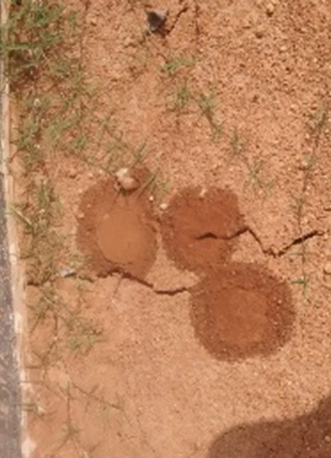
Acta hort regiotec, 24, 2021(1): 1–8

and geo-synthetic erosion control materials, may be            soils without considering the erosion. Limited studies
utilized to help in reducing erosion (Gray & Sotir, 1996).     (Zhang et al., 2014) attempted for evaluating the
In addition to these, use of asphalt concrete, articulated     combined effects of infiltration and vegetation on rain
block systems, construction and demolition wastes, and         induced erosion of surface soils of the MLCS.
lightweight manufactured aggregates can also be used
                                                               This study attempts to address this issue by monitoring
(Barnswell & Dwyer, 2012).
                                                               the infiltration of surface soils alongside the vegetation
Landreth et al. (1991) recommends a minimum cover              and erosion due to rainfall activity. The prime objective
soil thickness of 900 mm or greater for a few specific         of the study is to access the temporal variation in erosion,
types of MLCSs such as evapotranspiration or capillary         infiltration, and vegetation characteristics of surface layer
barrier cover system. The minimum thickness of surface         in a pilot Multilayered landfill cover system (MLCS) under
layer is established based on consideration of rooting         natural and controlled rainfall simulation events.
depth of surface vegetation, anticipated erosion rate,
and construction tolerances (Øygarden et al., 1997). For       2    Materials and methods
shallow-rooted plants such as certain grasses, a 150 mm
                                                               2.1 Study area
thick layer of soil usually provides adequate rooting
depth (Zhan et al., 2007). Thus, the minimum thickness         As understood from the above-mentioned literature,
of a vegetated surface layer is generally 150 mm (USEPA,       field monitoring programmes might solve such problems
1989). If plants with deeper roots are considered,             involving MLCS erosion. Hence for this study, a pilot MLCS
thickness of topsoil should be increased to accommodate        was constructed in the backyard of the civil engineering
the excess root growth (Blight, 2009). The most common         department, Indian Institute of Technology Guwahati,
material used to construct the surface layer is locally        India. Configuration and individual layer material of
available topsoil which contains adequate organic matter       field model were selected in accordance with the
and plant nutrients (Hoor and Rowe, 2013). It helps to
promote growth of vegetation (Khapre et al., 2017). Thus,
previous researchers (Schnabel et al., 2012; Song et al.,      Table 1        Basic characteristics of soils used in the study
2017) have had diverse opinions on the relation between                                                           Clayey silt
                                                                 Properties
erosion and infiltration in vegetated soils. Climatic                                                                (ML)
factors affect the types of vegetation that grow on MLCS         Specific gravity                                    2.65
surface layers (Bonaparte et al., 2002). Climatic criteria       Hygroscopic water content (%)                         5
for designing MLCSs may include quantity and seasonal            Saturated hydraulic conductivity (m.s-1)           2.9E-8
distribution of precipitation, intensity and duration of
                                                                 Specific surface area (m2.g-1)                       55
specific storm events, seasonal temperature variations,
depth of frost penetration, quantity of snow melt, wind          Linear shrinkage (%)                                  2
speed and direction, solar radiation, and humidity (Jarvis       Free swell index (%)                                 10
et al., 2011). Heavy rainfall for a prolonged period leads       % mass of gravel (>4.75 mm)                           0
to increase in rainwater infiltration and erosion of MLCS
                                                                 % mass of coarse sand (2.0–4.75 mm)                  17
(Maqsoud et al., 2011). Drier climate results in shrinkage
and desiccation cracks in MLCS surface layer (Landreth           % mass of medium sand (0.425–2.0 mm)                 16
et al., 1991). Cracks may also develop due to the effects        % mass of fine sand (0.075–0.425 mm)                 16
of freeze-thaw cycles in cold regions (Dune et al., 2011).       % mass of silt (0.002–0.075 mm)                      19
Repeated cycles of wetting and drying can induce
                                                                 % mass of clay (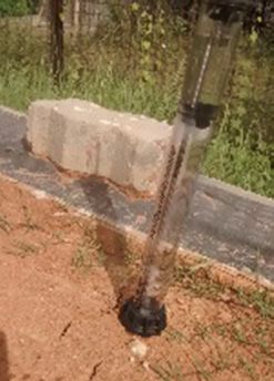
Acta hort regiotec, 24, 2021(1): 1–8

recommendations of the United States Environmental                 preparing the setup. The usual recommendation of cover
Protection Agency (USEPA, 1989). Soils used for the MLCS           slope angle is 3 to 7°, however, to understand the worst
model were locally collected from a nearby hill. The MLCS          probable performance a slope of 10° is adopted in this
is made of the conventional layers: hydraulic barrier,             study. The photograph of operational field set-up under
drainage system, and surface protection layer along with           simulated rainfall is presented in Fig. 1. The properties
various geosynthetic inclusions as additional barrier,             of rainfall simulator are in accordance with Shaikh et
drainage, and filter layers for superior performance.              al. (2019b). A micro weather station equipped with rain
Locally available hill soil, reddish in colour, was selected       gauge (ECRN 100 high-resolution double-spoon tipping
for its use as a surface protection layer. Geotechnical            bucket type rain gauge, Meter Group Inc. (2019a)) is
characterization of this surface soil was evaluated using          installed in the vicinity of field pilot MLCS. The weather
standard procedures in the ASTM guidelines (ASTM                   monitoring during the test period is summarized in Fig.
standard D422-63 (2007); ASTM standard D854 (2014);                2. The rainfall simulation experiments are started after
ASTM standard D5084 (2014); ASTM standard D4318                    finishing the regular monsoon for understanding the
(2017)), and corresponding results are summarized in               maximum possible erosion scenario.
Table 1. It was low plastic clayey silt soil (ML according
                                                                   The surface area is categorized into small grids for
to the Unified soil classification system (ASTM standard
                                                                   quantifying spatial heterogeneity in vegetation growth,
D2487, 2017)). This soil would depict moderate infiltration
                                                                   infiltration, and soil loss depth. The grid size was selected
and good resistance to erosion as understood from its
                                                                   based on the initial measurements of vegetation and
plasticity and density characteristics. However, a detailed
                                                                   infiltration. Fig. 3. illustrates the layout of 81 locations,
study would show an exact performance of the surface
                                                                   where the vegetation percentage, infiltration rate, and
soil with growing vegetation.
                                                                   eroded depth of soil surface are measured on surface
                                                                   protection layer of MLCS. The vegetation density was
2.2 Experimental set-up                                            measured in accordance with procedures detailed in
The construction of the pilot cover system, filling up             Gadi et al. (2017) by collecting photographic images
with materials, compacting every layer, erecting rainfall          of vegetated surface with varying time and processing
simulator, and installation of weather monitoring systems          them with a freeware Image analysis program (Image-J)
have been done with extreme care to avoid any kind of              similar to methods followed by Shaikh et al. (2019b).
experimental errors. The coefficient of uniformity for             The infiltration rate was attained through sequential
100 mm rainfall was found to be around 90% (Shaikh et              measurements of 150 ml Mini disk infiltrometer (MDI,
al., 2019a). About 8,000 kilograms of soils were used for          Meter Group Inc. (2019b)) at every location as mentioned

Figure 1      MLCS test setup during a rainfall simulation event

© Slovak University of Agriculture in Nitra                                Faculty of Horticulture and Landscape Engineering
www.uniag.sk                                                                                          http://www.fzki.uniag.sk
                                                              –3–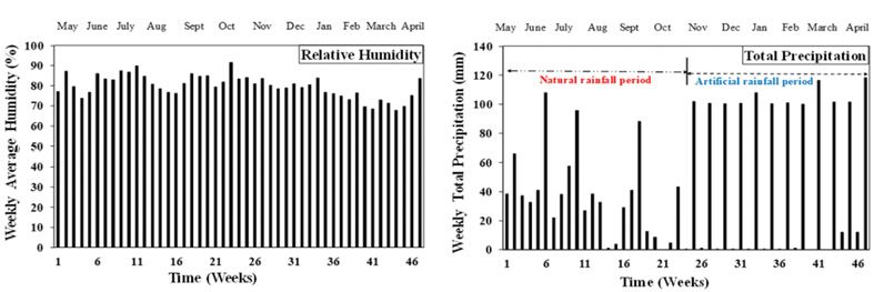
Acta hort regiotec, 24, 2021(1): 1–8

Figure 2      Weather monitoring during the test period monitored using ECRN 100

Figure 3      Schematic layout of measurement locations        Figure 4     Repeated infiltration measurements around
              involved in evaluating surface layer                          desiccation cracks on surface soil

in the grid. Measurements were repeated in locations           3   Results and discussion
with desiccation cracks and increased grass cover, to
account for all real field conditions as depicted in Fig. 4.   3.1 Temporal variation of infiltration, vegetation,
Further, the varying depth of surface is measured using            and erosion
Vernier calipers at different points, to attain a spatial      Fig. 5 depicts the contours describing the temporal
soil loss profile on temporal basis throughout the study       variation of infiltration rate, vegetation density, and
period.                                                        eroded depth of surface layer of the pilot MLCS under
                                                               above-shown weather conditions. Though the study
                                                               was conducted for one year and the data were evaluated

© Slovak University of Agriculture in Nitra                           Faculty of Horticulture and Landscape Engineering
www.uniag.sk                                                                                     http://www.fzki.uniag.sk
                                                           –4–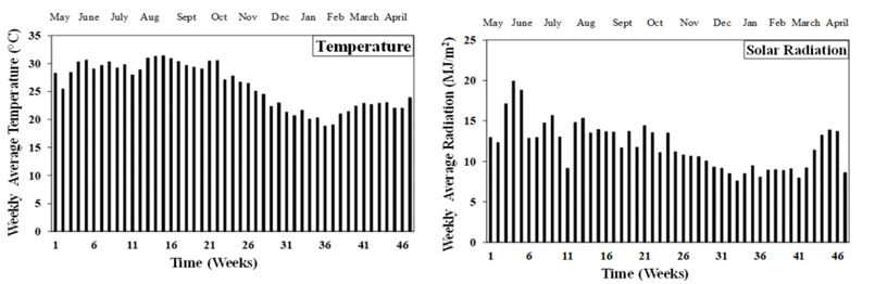
Acta hort regiotec, 24, 2021(1): 1–8

Figure 5      Temporal and spatial variation of infiltration, vegetation, and erosion

© Slovak University of Agriculture in Nitra                                 Faculty of Horticulture and Landscape Engineering
www.uniag.sk                                                                                           http://www.fzki.uniag.sk
                                                               –5–
Acta hort regiotec, 24, 2021(1): 1–8
on weekly basis, every two-month average results were (water retention on the plant leaves) was small. Hence,
considered in describing the contours to reduce the bigger proportion was distributed between infiltration
number of figures and have a representative picture. and surface runoff. This significantly influences the
From the depicted results it can be observed that within variation in runoff as well as the settlement of eroded
the initial days the amount of infiltration, vegetation soil mass. The settled soil mass near the toe region even
density, and eroded depth are relatively low indicating influenced the eroded depth to indicate a relatively lower
the effect of newly compacted surface layer. Similar value. However, all these variations are evident in initial
results are observed by Shrestha et al. (2005); Bhave and stages of study, and in later stages, a uniform variation
Sreeja (2013); Adams and Smith (2014); Yamsani et al. in observed parameters was noted. This could be likely
(2017). The infiltration was observed to vary 6E-09 to 1.5E- due to the controlled rainfall condition in simulation
06 throughout the study period. The least infiltration was experiments, relatively uniform weather conditions,
observed in months of July on the surface subjected to and due to increased stability because of enhanced
intense drying; such a behaviour is expected in general. vegetation density in months of November to March.
The variation in infiltration rate for a particular period of The all-time biggest soil loss depth was seen at the slope
time is about tenfold within the considered area of study. length of 4 m. This is likely due to lack of uniformity in
Greater degree of variation is observed with growing compacting the soil of this region or the presence of
vegetation. Variation was also observed around the mild some foreign loose matter in the soil of this region. The
cracks generated during the dry spell. However, it was observed low soil loss towards the toe region is likely due
also noted that these mild cracks were found to be closed to runoff sedimentation.
with high intensity rainfall simulations in the months of
November and December. As a result, there is a decrease 3.3 Influence of infiltration on erosion
in corresponding infiltration rate for that particular time. of vegetated soil
In general, the runoff and consecutive erosion are
The eroded depth of soil was observed to vary from 0 to
observed to be low when infiltration is high. However,
15 mm within the considered study period accounting
the surface dryness was noted to increase infiltration
to about 5% of the surface soil thickness (300 mm as
and erosion in the months of July to November due to
suggested in USEPA (1989)). Significant amount of
increased temperatures while the vegetation density
erosion was noted during the rainfall simulation period
was relatively low. And in the later stages of the study,
nearly 12 mm, while during natural rainfall only about 6
as the vegetation density increased, the water holding
mm of erosion was observed. The purpose of simulation
capacity of surface soil was observed to increase. Hence,
experiments was to observe the worst possible behaviour
the average infiltration rate in both wet and dry weeks
of surface soil layer. Fig. 2 depicts only 3 weeks of about
was observed to increase. Such findings were reported in
100 mm cumulative precipitation during the natural
Gadi et al. (2017) while studying hydraulic conductivity in
monsoon, and there were only couple of cloud burst
green infrastructures. During this stage, the erosion rate
events accounting to about 70 mm rainfall during the
is relatively low in comparison to early stages of study.
natural cycle. Consecutive simulation of 12 cloud burst
In summary, this indicates the strong interplay between
events has generated about 12 mm depth of soil loss.
the infiltration and erosion behaviour of vegetated
In this 12 mm of erosion depth, most of it was observed
soil. For better understanding the relation between
in the early months of July to November. Further, no
infiltration and erosion behaviour of vegetated soil, an
significant variations in depth of erosion were noticed
integrated model that considers continuous changes of
from months of November to March indicating nearly
these parameters and resulting degradation needs to
stable behaviour. Increased vegetation density and
be developed. Such a study would bring a preliminary
reduced climatic variations might be attributed for this
inference in developing effective soil loss models for
stable behaviour which was similar to the observation
surface soils used in MLCSs.
made by Shaikh et al. (2019b).
3.2 Spatial variation of infiltration, vegetation, 4 Conclusions
and erosion This article deals with the field evaluation of surface soil
Early results in Fig. 5, indicate that the infiltration increased layer of a pilot MLCS in terms of its erosion and infiltration
with increasing the length of the slope. Infiltration in the rate under the influence of natural and simulated rainfall
toe regions was relatively high owing to the loose soil for a period of a year. The study evidently presented the
structure formed as a result of erosion from crest of the diverse reasons behind contrasting behaviour of erosion
slope. In contrast, the vegetation density is relatively at higher rates of infiltration in vegetated and partially
low towards the toe region. Thus, the interception vegetated soil. Antecedent moisture contents have
© Slovak University of Agriculture in Nitra Faculty of Horticulture and Landscape Engineering
www.uniag.sk http://www.fzki.uniag.sk
–6–Acta hort regiotec, 24, 2021(1): 1–8
greater influence on erosion and infiltration behaviour Gadi, V. K., Tang, Y. R., Das, A., Monga, C., Garg, A., Berretta,
of surface soils. The rate of infiltration was observed to C. & Sahoo, L. (2017). Spatial and temporal variation of hydraulic
conductivity and vegetation growth in green infrastructures
increase during days of no rainfall due to the formation of
using infiltrometer and visual technique. Catena, 155, 20–29.
surface desiccation cracks and low in-situ water contents.
Ghosh, B., Pekkat, S., & Yamsani, S. K. (2019). Evaluation
Further, the infiltration was found to decrease with partial
of infiltrometers and permeameters for measuring hydraulic
closure of desiccation cracks and increase in antecedent conductivity. Advances in Civil Engineering Materials, 8(1).
water contents owing to high intensity rainfall during Gray, D. H., & Sotir, R. B. (1996). Biotechnical and Soil
simulated rainfall study. The high soil losses due to Bioengineering Slope Stabilization: A Practical Guide for Erosion
erosion during simulated rainfall events decreased Control. New York: John Wiley & Sons.
significantly, as the vegetation increased. Vegetation was Gross, B. A., Bonaparte, R., & Giroud, J. P. (2002). Waste
found to have significant effect on reducing the soil loss containment systems: problems and lessons learned (Appendix F
depth of surface soil layer of MLCSs. The study indicates in Assessment and Recommendations for Optimal Performance
of Waste Containment Systems). US Environmental Protection
the need of bioengineering for protecting the surface
Agency, National Risk Management Research Laboratory.
layer of MLCSs.
Hoor, A., & Rowe, R. K. (2013). Potential for desiccation
of geosynthetic clay liners used in barrier systems. Journal
Acknowledgments of Geotechnical and Geoenvironmental Engineering, 139(10),
The authors would like to thankfully acknowledge the 1648–1664.
board of research in nuclear sciences (BRNS), Department Jarvis, A., Ramirez, J., Bonilla-Findji, O., & Zapata, E. (2011).
of Atomic Energy (DAE), India for the financial support Impacts of climate change on crop production in Latin America.
provided for the work reported in this paper vide project Crop adaptation to climate change (pp. 44–56).
no. 2013/36/06-BRNS. Khapre, A., Kumar, S., & Rajasekaran, C. (2017). Phytocapping:
an alternate cover option for municipal solid waste landfills.
Environmental Technology, Taylor & Francis, 6, 1–8.
References Koerner, R. M., & Daniel, D. E. (1997). Final covers for solid
Adams, M. P., & Smith, P. L. (2014). A systematic approach to waste landfills and abandoned dumps. Thomas Telford, ASCE
model the influence of the type and density of vegetation cover Press.
on urban heat using remote sensing. Landscape and Urban
Landreth, R. E., Daniel, D. E., Koerner, R. M., Schroeder, P.
Planning, 132, 47–54.
R., & Richardson, G. N. (1991). Design and construction of RCRA-
Anderson, C. E., & Stormont, J. C. (1997). Prediction of long- CERCLA final covers. Seminar Peblication.
term erosion from landfill covers in the southwest (No. CONF-
Maqsoud, A., Bussière, B., Aubertin, M., Chouteau, M., &
970208–PROC). USDOE, Washington, DC (United States). ASTM
Mbonimpa, M. (2011). Field investigation of a suction break
standard D2487 (2017). Standard practice for classification
designed to control slope-induced desaturation in an oxygen
of soils for engineering purposes (unified soil classification
barrier. Canadian Geotechnical Journal, 48(1), 53–71.
system).
Meter Group Inc. (2019a). Microclimate monitoring system
ASTM standard D422-63 (2007). Standard test method for
for measuring various weather parameters. Operator’s User
particle-size analysis of soils.
Manual. Meter Group Inc., Pullman, WA. Retrieved December
ASTM standard D4318 (2017). Standard test methods for 30, 2020 from https://www.metergroup.com/environment/
liquid limit, plastic limit, and plasticity index of soils. products/ecrn-100/
ASTM standard D5084 (2014). Standard test methods for Meter Group Inc. (2019b). Mini disk infiltrometer. Operator’s
measurement of hydraulic conductivity of saturated porous User Manual. Meter Group Inc., Pullman, WA 99163. Retrieved
materials using a flexible wall permeameter. December 30, 2020 from https://www.metergroup.com/
ASTM standard D854 (2014). Standard test method for environment/products/mini-disk-infiltrometer/
specific gravity of soil solids by water pycnometer. Morris, C. E., & Stormont, J. C. (1998). Evaluation of numerical
Barnswell, K. D., & Dwyer, D. F. (2012). Two-year performance simulations of capillary barrier field tests. Geotechnical and
by evapotranspiration covers for municipal solid waste landfills Geological Engineering, 16(3), 201–213.
in northwest Ohio. Waste Management, 32(12), 2336–2341. Nyhan, J. W. (2005). A Seven-Year Water Balance Study of an
Bhave, S., & Sreeja, P. (2013). Influence of initial soil Evapotranspiration Landfill Cover Varying in Slope for Semiarid
condition on infiltration characteristics determined using Regions. Vadose Zone Journal, 4(3), 466.
a disk infiltrometer. ISH Journal of Hydraulic Engineering, 19(3), Nyhan, J. W., Hakonson, T. E., & Drennon, B. J. (1990).
291–296. A water balance study of two landfill cover designs for semiarid
Blight, G. (2009). Solar heating of the soil and evaporation regions. Journal of Environmental Quality, 19(2), 281–288.
from a soil surface. Géotechnique, 59(4), 355–363. Øygarden, L., Kværner, J., & Jenssen, P. D. (1997). Soil erosion
Bonaparte, R., Daniel, D. E., & Koerner, R. M. (2002). Assessment via preferential flow to drainage systems in clay soils. Geoderma,
and Recommendations for Improving the Performance of Waste 76(1–2), 65–86.
Containment Systems. United States Environmental Protection Schnabel, W. E., Munk, J., Lee, W. J., & Barnes, D. L. (2012). Four-
Agency, Office of Research and Development, National Risk year performance evaluation of a pilot-scale evapotranspiration
Management Research Laboratory.
© Slovak University of Agriculture in Nitra Faculty of Horticulture and Landscape Engineering
www.uniag.sk http://www.fzki.uniag.sk
–7–Acta hort regiotec, 24, 2021(1): 1–8
landfill cover in Southcentral Alaska. Cold Regions Science and Song, L., Li, J. H., Zhou, T., & Fredlund, D. G. (2017).
Technology, 82, 1–7. Experimental study on unsaturated hydraulic properties of
Shaikh, J., Bordoloi, S., Yamsani, S. K., Sekharan, S., Rakesh, R. vegetated soil. Ecological Engineering, 103, 207–216.
R., & Sarmah, A. K. (2019a). Long-term hydraulic performance of Swope, G. L. (1975). Revegetation of Landfill Cover Sites.
landfill cover system in extreme humid region: Field monitoring Pennsylvania State University, State Park, PA.
and numerical approach. Science of the Total Environ., 688, USEPA. (1989). Requirements for hazardous waste landfill
409–423. design, construction, and closure (pp. 1–127. Seminar publication,
Shaikh, J., Yamsani, S. K., Bora, M. J., Sekharan, S., Rakesh, Report No. 625/4-89/022). United States Environmental
R. R., Mungale, A., & Bordoloi, S. (2019b). Impact assessment Protection Agency.
of vegetation growth on soil erosion of a landfill cover Xue, Q., Chen, Y. J., & Liu, L. (2016). Erosion characteristics
surface. Acta Horticulturae et Regiotecturae, 22(2), 75–79. of ecological sludge evapotranspiration cover slopes for landfill
Shaikh, J., Bordoloi, S., Leung, A. K., Yamsani, S. K., Sekharan, closure. Environmental Earth Sciences, 75(5), 419.
S., & Rakesh, R. R. (2021). Seepage characteristics of three- Yamsani, S. K., Kumar, S., Sekharan, S., & Ranjan, R. R. (2017).
layered landfill cover system constituting fly-ash under extreme Determination of soil erosion index for surface soils of landfill
ponding condition. Science of the Total Environ., 758, 143683. covers. Environmental Geotechnics, 6(6), 373–380.
Sherard, J. L., Dunnigan, L. P., & Decker, R. S. (1976). Zhan, T. L., Ng, C. W., & Fredlund, D. G. (2007). Field study
Identification and Nature of Dispersive Soils. Journal of the of rainfall infiltration into a grassed unsaturated expansive soil
Geotechnical Engineering Division, 102(GT4), 287–301. slope. Canadian Geotechnical Journal, 44(4), 392–408.
Shrestha, G., Stahl, P. D., & Ingram, L. (2005). Influence of Zhang, X., Yu, G. Q., Li, Z. B., & Li, P. (2014). Experimental
reclamation management practices on soil bulk density and study on slope runoff, erosion and sediment under different
infiltration rates on surface coal mine lands in Wyoming. National vegetation types. Water resources management, 28(9),
Meeting of the American Society of Mining and Reclamation (pp. 2415–2433.
1042–1056), Lexington, KY: ASMR.
Sinnathamby, G., Pasky, A., Phillips, D. H. H., & Sivakumar, nnn
V. (2014). Landfill cap models under simulated climate change
precipitation: impacts of cracks and root growth. Géotechnique,
64(2), 95–107.
© Slovak University of Agriculture in Nitra Faculty of Horticulture and Landscape Engineering
www.uniag.sk http://www.fzki.uniag.sk
–8–You can also read