Kangaroo Island Rapid Bird Assessments, February 2020 - March 2020 Rebecca L. Boulton, Thomas J. Hunt, Luke J. Ireland and Janelle L. Thomas
←
→
Page content transcription
If your browser does not render page correctly, please read the page content below
Kangaroo Island Rapid Bird Assessments,
              February 2020

                     March 2020

Rebecca L. Boulton, Thomas J. Hunt, Luke J. Ireland and
                  Janelle L. Thomas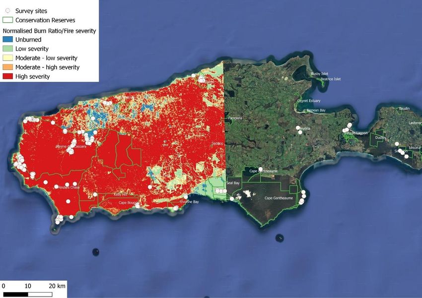
Report produced by
BirdLife Australia
Suite 2-05
60 Leicester Street
Carlton VIC 3053
T (03) 9347 0757
W www.birdlife.org.au
© BirdLife Australia. This report is copyright. Apart from any fair dealings for the purposes of
private study, research, criticism, or review as permitted under the Copyright Act, no part
may be reproduced, stored in a retrieval system, or transmitted, in any form or by means,
electronic, mechanical, photocopying, recording, or otherwise without prior written
permission. Enquiries to BirdLife Australia.
This report is licensed under Creative Commons Attribution 3.0 Australia licence
(http://creativecommons.org/licenses/by/3.0/au/deed.en).

Recommended citation
Boulton, R. L., Hunt, T. J., Ireland, L. J. and Thomas, J. L. (2020). Kangaroo Island Rapid
Bird Assessments, February 2020. Birdlife Australia, Melbourne.

Disclaimers
Every effort has been undertaken to ensure that the information presented within this
publication is accurate. BirdLife Australia does not guarantee that the publication is without
flaw of any kind and therefore disclaims all liability for any error, loss or other consequence
that may arise from relying on any information in this publication.
The views and opinions expressed in this publication are those of BirdLife Australia and do not
necessarily reflect those of the Western Local Land Services.
While reasonable efforts have been made to ensure that the contents of this publication are
factually correct, BirdLife Australia does not accept responsibility for the accuracy or
completeness of the contents, and shall not be liable for any loss or damage that may be
occasioned directly or indirectly through the use of, or reliance on, the contents of this
publication.

Acknowledgments
This project was supported by the Department of Environment and Water.

February 2020
Contents
Introduction................................................................................................................. 1
Methods ...................................................................................................................... 3
Results........................................................................................................................ 4
Discussion ................................................................................................................... 22
Recommendations ........................................................................................................ 23
References .................................................................................................................. 24
Appendix I ................................................................................................................... 25

February 2020
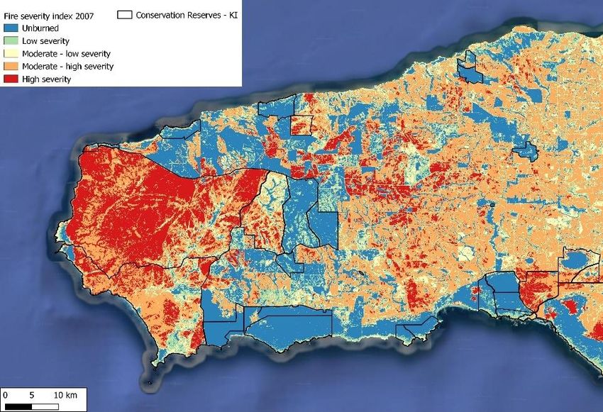
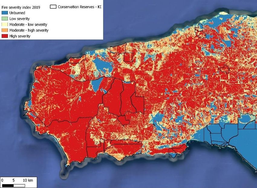
Introduction
Wildfires fuelled by catastrophic fire conditions and below average rainfall swept across
Kangaroo Island from the 20th of December 2019. Over several weeks, the fires burnt
210,606 ha, just under half of the island, including the vast majority of Flinders Chase
National Park and Ravine des Casoars Wilderness Protection Area. Wildfires at this scale were
last seen in the western parks of Kangaroo Island in 2007 when the majority of these two
parks burnt (Fig. 1a). However, the 2007 fires were reasonably contained within the park
boundaries, only burning 75,000 ha and burnt with much less intensity leaving a small but
connected mosaic of unburnt habitat, particularly within the central Flinders Chase region
(Fig. 1b). The 2019/2020 wildfires by comparison burnt with much more intensity, hence the
inability to contain the fires within the park boundaries (Fig. 1c). As a result, large areas of
native vegetation on private land was also burnt.

Kangaroo Island, particularly the western half, has retained relatively high coverage and
quality of its native vegetation, resulting in many species of animal and plants being either
unique to the island (both species and subspecies) or faring considerably better than their
mainland counterparts. The ecological impact of these fires – in addition to the economic
impact, especially through tourism –is therefore likely to be high. Initial fire mapping has
shown many bird species have lost major proportions of their habitat on Kangaroo Island.
Understanding where these birds may now be residing within the burnt landscape is an
important step towards enacting threat abatement actions and will provide baseline data to
assess their future recovery and recolonisation as the habitat regenerates.

February 2020                                                                                   1
a           b

                Figure 1. Fire severity index using Landsat (see methods below) a)
                comparison of 2007 fire scar with 2019/2020 fire scar, b) fire severity
                index for 2007 fire and c) fire severity index for 2019/2020 fire. Maps
                produced by L. Ireland.

    c

February 2020

                                   2
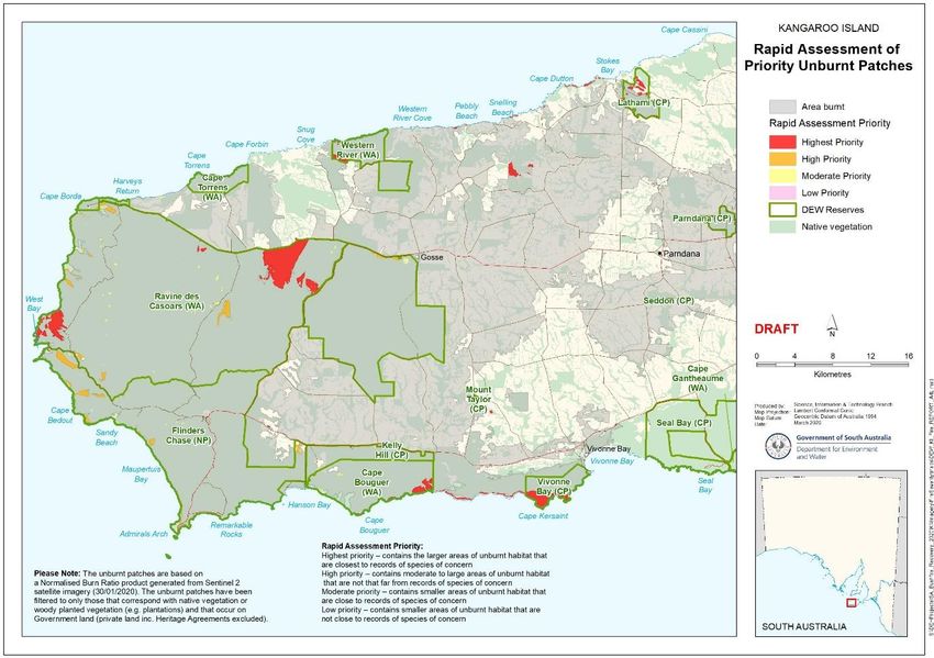
Methods
FIRE SEVERITY CALCULATION METHODS: Fire severity maps were created to assist in
selecting unburnt or partially unburnt patches within the fire scar in which to target search
effort. These maps were created by calculating the Normalised Burn Ratio (NBR) designed to
highlight burnt areas and estimate burn severity. Near-infrared (NIR) and shortwave-infrared
(SWIR) wavelength bands from Landsat 7 (for 2007) and Landsat 8 (for 2019) satellite
imagery were used to calculate the following formulae for delta NBR:

Pre-fire NBR = (NIR - SWIR) / (NIR + SWIR)

Post-fire NBR = (NIR - SWIR) / (NIR + SWIR)

Delta NBR = Pre-fire NBR – Post-fire NBR

Healthy vegetation before the fire has very high near-infrared reflectance and low reflectance
in the shortwave infrared part of the spectrum, in contrast to recently burned areas that have
a low reflectance in the near-infrared and high reflectance in the shortwave infrared band.
The NBR is calculated for images before the fire (pre-fire NBR) and for images after the fire
(post-fire NBR) and the post-fire image is subtracted from the pre-fire image to create the
differenced (or delta) NBR (dNBR) image. dNBR can be used for burn severity assessment, as
areas with higher dNBR values indicate more severe damage whereas areas with negative
dNBR values might show increased vegetation productivity.

BIRD SURVEYS: From the 20–28th February 2020, three experienced ecologists undertook
bird surveys across Kangaroo Island (Fig. 2 & 3). The major objective was targeted surveys
of unburnt vegetation on public land within the fire scar to determine what species were still
present. Given the nature of the fire, these unburnt patches varied considerably both in size
and vegetation composition. Surveys were guided by maps provided by Department of
Environment and Water that depicted prioritised unburnt patches within parks (Fig. 2), a fire
severity map produced by Luke Ireland (Fig. 1c) and ease of access.

Unburnt patches ranged in size from approximately 2 ha (Remarkable Rocks patch) to 1200
ha (“A-Wedge”). For smaller patches the whole area was traversed, but for larger patches a
subsample was surveyed. Given the different sizes and vegetation structure, with some sites
being almost impenetrable, standardised surveys were not possible. Where feasible, surveys
followed the standardised 2 ha, 20 min active area search method (Loyn 1985) or a 500 m
area search. Area searches generally lasted between 20–60 min to allow for good coverage of
the patch; if the area was large enough each observer surveyed a different section (>500m
apart). Incidental records of target species (Southern Emu-wren, Beautiful Firetails, Western
Bassian Thrush, and Western Whipbird) were also taken. Call playback was occasionally used
in suitable habitat to help locate Southern Emu-wren and Western Whipbird.

February 2020                                                                                    3

Figure 2. Priority unburnt patches within the park’s boundaries targeted during the rapid bird
assessments, Kangaroo Island, South Australia, 20–28th February 2020. Map produced by D.
Thompson (DEW). Distance to historic records of priority species (Table 1) dictated patch priority
level.

Results
In total, 145 sites were surveyed, with 35 of these outside the fire area (Fig. 3). A mixture of
incidental sightings of target species (n = 58), 2 ha 20 min surveys (n = 41) and 500 m area
searches (n = 46) were undertaken. Table 1 lists the Kangaroo Island subspecies and other
species of conservation concern identified by BirdLife Australia and the Department of
Environment and Water and recorded during the surveys, with a total of 77 species and
2,654 individual birds recorded (see Appendix I).

In general, the fire severity map was accurate. At times, areas that were depicted as having
burnt at low severity, were tall Sugar Gums (Eucalyptus cladocalyx) with canopy leaves still
attached but scorched, with little to no understorey remaining (Fig. 7). An area off Shackle
Road in Ravine des Casoars Wilderness Protection Area was the only location where the
surveyors found ‘patchily’ burnt vegetation, which was supporting Southern Emu-wrens and
Western Whipbirds (see photos below). It was also around this area that the only Bassian
Thrush were detected near a burnt-out swamp along Bull Creek.

February 2020                                                                                        4
Lathami CP

                             Western
                             River CP
    Cape
    Borda

                          A-Wedge

                Shackle Rd
                                                                                          Simpson
                                                                                          CP
  West Bay

                                                      Seal Bay         Cape
                                Cape       Vivonne
                                                      CP               Gantheaume
                                Bouguer    Bay CP
                Cape du
                                Wilderness
                Couedic
                                PA CP

Figure 3. Bird survey sites across Kangaroo Island, South Australia from the 20–28th February
2020. Fire severity is depicted on the western end of the island where surveys were concentrated
within Flinders Chase National Park and Ravine des Casoars Wilderness Protection Area. Yellow
circles enclose a group of surveys within unburnt vegetation within the fire scar and blue circles
enclose a group of surveys outside fire area.

February 2020                                                                                        5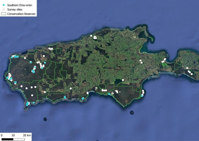
Table 1. List of Kangaroo Island subspecies and other species of conservation concern observed
during the 145 surveys, 35 outside the fire area, from 20–28th February 2020.

                                         No. of surveys    Sites within     No. of
 Species
                                           detected          fire scar    individuals
 KI Superb Fairy-wren                           77              62            245
 KI Spotted Scrubwren                           77              58            177
 KI New Holland Honeyeater                      73              61            330
 KI Southern Emu-wren                           41              37            108
 KI Brown Thornbill                             40              29             81
 KI Grey Currawong                              35              26             45
 KI Striated Thornbill                          34              28            105
 KI Western Whipbird                            28              25             42
 KI Crimson Rosella                             24              24             89
 KI Shy Heathwren                               24              24             31
 KI Red Wattlebird                              21              12             42
 KI Purple-gaped Honeyeater                     16              9              46
 KI Brown-headed Honeyeater                     14              13             48
 Beautiful Firetail                             14              14             26
 KI White-eared Honeyeater                      10              10             15
 Eastern Yellow-tailed Black-Cockatoo           3               3              30
 KI Glossy Black-Cockatoo                       2               2              9
 KI Little Wattlebird                           2               2              3
 South-eastern Boobook                          2               0              2
 Western Bassian Thrush                         1               1              2

February 2020                                                                                    6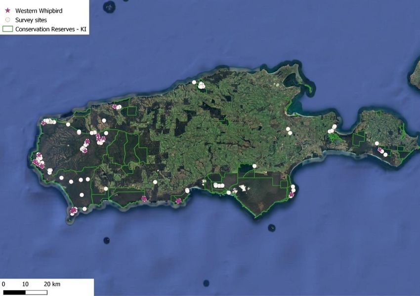
KANGAROO ISLAND SOUTHERN EMU-WREN Stipiturus malachurus halmaturinus
Baxter (2015) describes the Southern Emu-wren as moderately common in the south and
west coastal mallee heath from Cape Willoughby west to Cape du Couedic and north to Cape
Borda, along the north coast from Cape Borda to Western River Conservation Park, and
throughout stunted whipstick mallee/stringybark growing on the ironstone plateau.

A male Kangaroo Island Southern Emu-wren (Stipiturus malachurus halmaturinus) using Slender
Honey-myrtle (Melaleuca gibbosa) at Vivonne Bay Conservation Reserve. Photo T. Hunt.

Southern Emu-wrens were encountered in nearly all the survey areas within the fire scar,
except Lathami Conservation Park and Western River Conservation Park (Fig. 4). They did not
respond readily to call playback if used, but frequently responded with alarm calls or song to
the observer walking through the habitat. They were often associated with fairy-wrens, and
at times produced very similar calls which made detection and recording numbers
challenging.

Outside the fire area emu-wrens were detected in three sites at Seal Bay, and a single bird
was heard at Cape Gantheaume Wilderness Area. The eastern end of the island receives less
rainfall than the north-west, and conditions here appeared drier. These patches likely support
lower densities of birds than the west, an observation supported by D. Paton (pers. comm.).

February 2020                                                                                 7
Figure 4. Survey sites where Kangaroo Island Southern Emu-wrens were detected (blue dots)
across Kangaroo Island, South Australia, 20–28th February 2020.

February 2020                                                                               8
Typical habitat Southern Emu-wrens were in during Kangaroo Island surveys
 Low open shrubland. Olearia axillaris, Leucopogon parviflorus, also   Melaleuca lanceolata open shrubland
 containing Correa backhouseana var. orbicularis, Goodenia varia,      also containing Melaleuca gibbosa and Goodenia varia.
 Myoporum insulare and Lasiopetalum schulzenii. Southeast corner of    Southeast corner of Cape Bouger Wilderness Area.
 Cape Bouger Wilderness Area.

 Low open coastal shrubland containing Leucopogon                      Low open coastal shrubland containing Leucopogon
 parviflorus, Correa backhouseana var. orbicularis,                    parviflorus, Correa backhouseana var. orbicularis, Goodenia
 Goodenia varia, Myoporum insulare and Olearia axillaris.              varia, Myoporum insulare and Olearia axillaris. Near
 Cape du Couedic, approximately 500 m south of the lighthouse.         Remarkable Rocks.

February 2020

                                                                                                9
21-Feb-2020. Single female Southern Emu-wren flushed from the centre of overgrown track (off top of Ravine Road, near Cape Borda). Small area 20 x 30 m of unburnt vegetation. A couple of other strips of unburnt vegetation along Ravine Road 2 x 20 m. 22-Feb-2020. Northern end of Shackle Road, Ravine des Casoars was one of the only areas observed where fire intensity was low with small (5 x 10 m) unburnt patches scattered throughout the scorched vegetation. a) Single Southern Emu-wren observed, and 3-6 Western Whipbirds heard calling in vicinity. b) Southern Emu-wren observed foraging and moving through narrow roadside vegetation strip containing Banksia ornata, Allocasuarina striata and Calytrix tetragona. 24-Feb-2020. Four Southern Emu-wrens located in the unburnt area directly west of Cape du Couedic lighthouse. Emu-wrens were found in similar habitat further south towards Admirals Arch and in a small (2 ha) unburnt patch west of Remarkable Rocks. February 2020 10
KANGAROO ISLAND WESTERN WHIPBIRD Psophodes nigrogularis lashamri
Baxter (2015) describes the Western Whipbird as uncommon, occurring mostly along the
south and west coastal mallee belt from Cape Borda to Cape du Couedic and then east to
Cape Willoughby. It is also widespread, albeit in lower density, throughout the elevated
plateau of Flinders Chase National Park and along north coast from Cape Borda east to
Western River Conservation Park. Isolated occurrences in the more fragmented eastern
districts include Beyeria Conservation Park, Nepean Conservation Park/Western Cove and
Point Morrison area.

An immature Kangaroo Island Western Whipbird (Psophodes nigrogularis lashamri) in low coastal
heath at Cape du Couedic, Flinders Chase National Park. Photo T. Hunt.

Western Whipbirds were encountered in nearly all the survey areas within the fire scar,
except Lathami Conservation Park (Fig. 5). They were relatively responsive to call playback
when used, though patience was required to detect them as they often skulked silently
around the observer or only called after playback finished (up to 20 minutes later). Outside
the fire area whipbirds were detected at two sites in Cape Gantheaume Conservation Park
and a single site at Simpson Conservation Park.

Two whipbirds were found in small patches of scorched vegetation near roadsides on Cape du
Couedic (see photos below), indicating birds are at least attempting to move through the
landscape. However, these observations were never far from larger areas of intact habitat, so
the capacity for these birds to move between isolated remnants of unburnt vegetation is
unknown.

February 2020                                                                                  11
Figure 5. Survey sites where Kangaroo Island Western Whipbirds were detected (purple stars)
across Kangaroo Island, South Australia, 20–28th February 2020.

February 2020                                                                                 12
Typical habitat Western Whipbirds were found in during surveys
 Taller Melaleuca lanceolata open shrubland also containing Correa   Eucalyptus diversifolia mallee also containing Acacia paradoxa,
 backhouseana var. orbicularis and Leucopogon parviflorus. Pair of   Melaleuca lanceolata, Choretrum glomeratum, Hakea rostrata and
 duetting whipbirds heard here. Feral cat (Felis catus) and          Allocasuarina verticillata. West Bay area, Flinders Chase National
 Rosenberg’s Goanna (Varanus rosenbergi) tracks were also recorded   Park.
 at the site. Vivonne Bay Conservation Park.

February 2020

                                                                                    13
Typical habitat Western Whipbirds were found in during surveys
One Western Whipbird seen moving through a narrow strip of burnt Melaleuca lanceolata and Eucalyptus diversifolia open shrubland also
roadside vegetation. This strip contains Melaleuca lanceolata and containing Lasiopetalum discolour and Melaleuca gibbosa. One
Lasiopetalum discolour. Cape du Couedic area, approximately 1.4 km Western Whipbird observed flying across the road into a small patch
northeast of Cape du Couedic Lighthouse. of unburnt vegetation. Other patches of unburnt vegetation persist
nearby. Cape du Couedic area, approximately 1.5 km north of the
lighthouse.
February 2020
1425-Feb-2020. At least three Western Whipbirds located here in thick unburnt vegetation dominated by Eucalyptus diversifolia, Melaleuca lanceolata and Olearia axillaris, Vivonne Bay Conservation Area. Emu-wrens were found in the same area but closer to the cliffs in coastal scrubland; Melaleuca lanceolata, Leucopogon parviflorus, Olearia axillaris, Correa pulchella. 27-Feb-2020. Cape Gantheaume Western Whipbird site; Eucalyptus diversifolia, Melaleuca lanceolata, Hakea mitchellii, Spyridium sp. February 2020 15
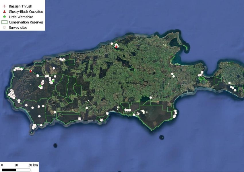
Western Bassian Thrush Zoothera lunulata halmaturina
Baxter (2015) describes the Bassian Thrush as uncommon, occurring in mostly secluded,
forested river valleys of western Kangaroo Island. Only a single pair of thrush were located
during the surveys (Fig. 6), in a burnt-out swamp off Shackle Road (see photo below). Gullies
in the fire fared badly, with dry conditions and plenty of fuel resulting in mostly consumed
understory vegetation. This contrasts with the 2007 fires where fire mapping indicates much
of the gully and creekline vegetation was less severely burnt by the fire. Bassian Thrush
detection is likely to be reduced during the non-breeding season, with targeted surveys using
acoustic recorders preferable from May when birds begin breeding (R. Boulton pers. comm.
from Mt Lofty Ranges).

Figure 6. Survey sites where Western Bassian Thrush (pink cross), Glossy-Black Cockatoos (red
triangle) and Kangaroo Island Little Wattlebirds (green star) were detected across Kangaroo
Island, South Australia, 20-28th February 2020.

February 2020                                                                                   16
Western Bassian Thrush, Bull Creek. Photo T. Hunt.

22-Feb-2020. a) The swamp along Bull Creek where a pair of Western Bassian Thrush were
observed foraging, Ravine des Casoars Wilderness Protection Area, and b) Rocky River gully in
Flinders Chase National Park.

February 2020                                                                                   17
Kangaroo Island Little Wattlebird Anthochaera chrysoptera halmaturina
Only two Little Wattlebirds were found during the surveys (Fig. 6). Historic records for Little
Wattlebird tended to concentrate on Flinders Chase National Park area, an area significantly
burnt. The species is likely to be relatively mobile, whether this should have made them more
abundant or less is unknown as extensive searches in the eastern end of the island were not
undertaken to address an easterly movement after the fire.

Kangaroo Island Glossy Black-Cockatoo              Calyptorhynchus lathami halmaturinus
Glossy Black-Cockatoos were found in two locations (Fig. 6). Eight birds were seen along a
gully on Cape Borda Road in the north-west of the island. The area was not completely
consumed, although most of the understorey was, with only the Sugar Gums (Eucalyptus
cladocalyx) still retaining their leaves (Fig. 7). A Glossy Black-Cockatoo nest box was intact
on a nearby tree. The second recording was birds heard near Lathami Conservation Park, a
known feeding and breeding area for Glossy Black-Cockatoos. It must be noted that these
rapid assessment surveys did not specifically target Glossy Black-Cockatoos as the Recovery
Team were already undertaking their own survey work at the time.

A male Kangaroo Island Glossy Black-Cockatoo (Calyptorhynchus lathami halmaturinus), foraging
on revegetated Drooping Sheoak (Allocasuarina verticillata), Cygnet River. Photo T. Hunt.

February 2020                                                                                18
Figure 7. Gully on Cape Borda road where Glossy Black-Cockatoos were observed. The Sugar
Gums (Eucalyptus cladocalyx) retain a scorched canopy but most of the understorey has been
consumed by fire.

Kangaroo Island Shy Heathwren Calamanthus cautus halmaturina
Shy Heathwren were detected in unburnt patches particularly in the north-west of the island
(Fig. 8) and were sometimes detected in small strips of unburnt roadside vegetation. One
observation was recorded of a Shy Heathwren foraging for invertebrates in the fire scar about
500 metres from the nearest patch of unburnt vegetation (see Fig. 9).

February 2020                                                                                19
Figure 8. Survey sites where Kangaroo Island Shy Heathwrens were detected (red cross) across
Kangaroo Island, South Australia, 20-28th February 2020.

Figure 9. Kangaroo Island Shy Heathwren (Calamanthus cautus halmaturina) foraging for
invertebrates in the fire scar, Cape Borda. Photo T. Hunt.

February 2020                                                                                  20
Beautiful Firetail Stagonopleura bella
Beautiful Firetails were encountered relatively frequently in most sites on the north-west of
the island (Fig. 10). None were detected outside the fire area.

Beautiful Firetail (Stagonopleura bella) foraging for seeds, Cape Borda Lighthouse. Photo T. Hunt.

Figure 10. Survey sites where Beautiful Firetails were detected (red diamond) across Kangaroo
Island, South Australia, 20-28th February 2020.

February 2020                                                                                    21
Discussion
There appears to be justifiable concern for the long-term recovery of the bird populations on
the western side of Kangaroo Island. Despite the ease of detecting some species in unburnt
patches (even normally difficult species such as the emu-wrens and whipbirds) it is possible
that these birds are in higher than normal densities in these refuges. They certainly appear to
have the ability to retreat to even very small patches during or immediately after the fire, as
was seen on private property where 20 emu-wrens were observed in a 20 x 20 m unburnt
patch (P. Hodgens pers. comm.) Whether these densities are higher than normal, and how
long these refuges can support these numbers of birds is unknown, as is their ability to
sustain or support breeding birds during future breeding events.

The extent and severity of the fire is much greater than the previous 2007 fire; after that
event, low-intensity burns left a patchy mosaic of unburnt or scorched but connected
vegetation throughout the western half of the island. The few corridors of vegetation
remaining after the 2019/2020 fires are mostly limited to small, narrow strips along the cliff
faces. Recovery will require birds to persist in small numbers in unburnt patches (possibly
only 8–12 large sized patches) waiting for the surrounding vegetation to recover to levels
where they can forage and then ultimately breed. How long this takes will depend on both the
plant and bird species in question. Additional perturbations such as dry or unfavourable
climatic conditions, competition for resources with conspecifics and other species, and
increased predation due to reduced cover and increased numbers of predators in remnant
vegetation will create further challenges for the persistence of these birds. Any movement of
birds across the open and exposed areas of the fire scar, as well as any foraging that may
occur as birds look for additional resources, will incur an increased risk of predation until the
vegetation regenerates sufficiently to provide increased cover. It may take many months or
years for the vegetation to reach this state.

Relying on the eastern side of the island as a source of birds for recovery is ambiguous, as its
unlikely to be as productive as the west with drier conditions and hence fewer birds
dispersing. Distances between the eastern remnant patches on Dudley Peninsula and the
regenerating vegetation in the west are likely prohibitive for these areas to act as viable
source populations for most species. In addition, the open and cleared agricultural areas
between remnant patches host few corridors of suitable habitat for birds to move through,
particularly for those species of conservation concern, and any movement that does occur will
also be accompanied by an increased risk of predation, harmful interactions with artificial
structures (e.g. fencelines) and vehicle collisions across roads. This leaves Cape Gantheaume
Conservation Park and Wilderness Protection Area as the only large, intact and connected
habitat remaining. Though it couldn’t be comprehensively searched, the relatively low
numbers of birds recorded in the eastern end of this area suggest it is unlikely to be a major
source site for many of the priority species.

The unburnt vegetation on private property to the north of the “A-Wedge” could play a major
role in helping to repopulate the western side of the island. Much of this land is currently
being managed for wildlife conservation, e.g. cat control implemented through Kangaroo
Island Land for Wildlife. Similar cat management may help improve survival and breeding in
unburnt patches within the parks as species cannot rely on dispersal from outside the fire
area to replenish numbers.

February 2020                                                                                 22
Recommendations
With limited baseline monitoring of species’ distributions and abundances before the
2019/2020 fires, it is difficult to determine whether the densities of birds observed in these
surveys are unsustainably high for the given resources in an unburnt patch, if the
occurrences of species have shifted markedly, and what capacity each species of concern has
to disperse between patches. As such, continued standardised monitoring of these species is
important over the coming months and years to provide robust baseline information with
which to make recommendations for conservation actions, both in the wake of these fires and
for those fires that may occur on a similar scale in the future.

     •     Additional surveys in unburnt refuges April–May 2020; possibly utilising local
           volunteers.
                o   Survey some of the smaller unburnt patches (e.g. along Shackle Road) to look
                    at bird numbers. If patch size and its ability to support bird’s medium-long
                    term is going to be a problem, birds will disappear from these smaller sites
                    first.
                o   Access and survey the unburnt areas in the Ravine Des Casoars, directly south
                    of Cape Borda. There is no road access to these sites, so they were not visited
                    during February due to time restraints.
                o   Comprehensive surveys on private properties managed for wildlife north of "A-
                    Wedge”.
                o   Re-survey February 2020 priority sites (selection based on ease of access,
                    importance for recolonisation); likely “A-Wedge”, Cape Borda, Cape du
                    Couedic, West Bay, Cape Bouguer and smaller patches along Shackle Road.
     •     Develop a monitoring program both within the burnt area to monitor recovery and the
           unburnt eastern side of the island to assess its ability to help with recolonisation.
                o   No one survey method will be efficient at monitoring all bird species; notably,
                    the relatively low detectability of Western Whipbird and Western Bassian
                    Thrush during a small-scale standardised survey means their presence is likely
                    to be missed. A workaround may be to complete the standardised 2 ha, 20
                    min active area search method embedded within a 500 m area search. This is
                    a survey technique already used within Birdlife Australia’s Birddata system,
                    though note that the Embedded Survey method is not available when entering
                    observations in the mobile Birdata app.
                    The standardised use of call playback for whipbirds and emu-wrens at the
                    beginning of the survey (e.g. 30 seconds of call playback coupled with 30
                    seconds of listening time for each species) may help increase detectability of
                    these species whilst keeping detectability between surveys consistent.
                o   Select priority unburnt patches for long-term monitoring. This monitoring
                    would require additional data on species abundance, something the 2 ha, 20
                    min methodology underestimates.
                o   The eastern sites could be accessed by volunteers as well as the more
                    accessible unburnt patches in the western half of the island. However,
                    experienced contractors are likely to be needed to undertake some of the
                    more detailed monitoring.
     •     Targeted Western Bassian Thrush surveys during winter months using AudioMoths.

February 2020                                                                                        23
• Cat control in unburnt priority patches.
• Coordinate habitat mapping (DEW & BirdLife) of difficult to access terrain (i.e. Cape
Gantheaume) and fire area.
References
Loyn, R. H. 1985. The 20-minute search: a simple method for counting forest birds.
Biological Survey Branch, State Forests and Lands Service.
February 2020 24Appendix I All birds (77 species) recorded during surveys on Kangaroo Island, South Australia 20-28th February 2020. Species Sum of Individuals Number of survey sites Australasian Gannet 1 1 Australian Magpie 15 9 Australian Pelican 3 3 Australian Pied Oystercatcher 1 1 Australian Raven 24 14 Australian Shelduck 52 1 Australian White Ibis 1 1 Bassian Thrush (Western) 2 1 Beautiful Firetail 26 14 Black-faced Cormorant 36 1 Black-faced Cuckoo-shrike 4 4 Brown Falcon 1 1 Brown Quail 1 1 Brown Thornbill (KI) 81 40 Brown-headed Honeyeater (KI) 48 14 Brush Bronzewing 1 1 Cape Barren Goose 2 1 Caspian Tern 1 1 Common Bronzewing 2 2 Common Starling 6 1 Crescent Honeyeater 89 31 Crested Tern 17 5 Crimson Rosella (KI) 89 24 Dusky Woodswallow 10 3 Eastern Spinebill 2 2 Elegant Parrot 3 2 European Goldfinch 4 3 Galah 32 7 Glossy Black-Cockatoo (KI) 9 2 Golden Whistler 36 28 Great Cormorant 2 2 Grey Currawong (KI) 45 35 Grey Fantail 26 21 Grey Shrike-thrush 8 5 Hooded Plover 8 5 House Sparrow 12 1 Indian Peafowl 6 1 Little Corella 15 1 Little Raven 30 11 Little Wattlebird (KI) 3 2 February 2020 25
Magpie-lark                     1     1
 Masked Lapwing                  18    3
 Nankeen Kestrel                 2     2
 New Holland Honeyeater (KI)    330    73
 Osprey                          3     3
 Pacific Gull                    12    6
 Painted Button-quail            7     5
 Peregrine Falcon                1     1
 Pied Cormorant                  4     2
 Purple-crowned Lorikeet        217    26
 Purple-gaped Honeyeater (KI)    46    16
 Rainbow Lorikeet                49    11
 Red Wattlebird (KI)             42    21
 Red-browed Finch                4     2
 Scarlet Robin                   37    24
 Shy Heathwren (KI)              31    24
 Silver Gull                     69    7
 Silvereye                      155    43
 Sooty Oystercatcher             7     3
 Southern Boobook                3     3
 Southern Emu-wren (KI)         108    41
 Spotted Pardalote               5     4
 Spotted Scrubwren (KI)         177    77
 Striated Pardalote              3     2
 Striated Thornbill (KI)        105    34
 Sulphur-crested Cockatoo        10    1
 Superb Fairy-wren (KI)         245    77
 Tawny-crowned Honeyeater        6     5
 Tree Martin                     34    11
 Wedge-tailed Eagle              10    6
 Welcome Swallow                 47    23
 Western Whipbird (KI)           42    28
 White-bellied Sea-Eagle         5     4
 White-eared Honeyeater (KI)     15    10
 White-fronted Chat              12    2
 Willie Wagtail                  8     7
 Yellow-tailed Black-Cockatoo    30    3

 Total                          2654

February 2020                               26
You can also read