Intelligent photogrammetry - Agisoft
←
→
Page content transcription
If your browser does not render page correctly, please read the page content below
Intelligent
photogrammetry

Agisoft
Agisoft Metashape is a cutting-edge software solution, with its engine core
driving photogrammetry to its ultimate limits, while the whole system is de-
signed to deliver industry specific results relying on machine learning techni-
ques for post-processing and analysis tasks.

The software allows to process images from RGB or multispectral cameras,
including multi-camera systems, into the high-value spatial information in
the form of dense point clouds, textured polygonal models, georeferenced
true orthomosaics and DSMs/DTMs. Further post-processing enables to eli-
minate shadows and texture artifacts from the models, calculate vegetation
indices and extract information for farming equipment action maps, auto-
matically classify dense point clouds, etc.
Very fast                             Local or cloud                          Intuitive UI
& highly accurate                     processing                              & stereo mode
Based on the state-of-the-art         Agisoft Metashape is capable of         The software package has a linear
technology developed by Agisoft,      processing of 50 000+ photos            project-based workflow that is
Metashape allows for very fast        across a local cluster, thanks to       intuitive and can be easily mastered
processing, providing at the same     distributed processing functionality.   even by a non-specialist, while pro-
time consistent and highly accurate   Alternatively, the project can be       fessional photogrammetrists can
results both for aerial and close-    easily sent to the cloud to minimize    benefit from advanced features like
range photography (up to 3cm for      hardware investment, with all           stereo mode and have complete
aerial, and up to 1mm for close-      the processing options being still      control over the results accuracy,
range photography).                   available.                              with detailed report being genera-
                                                                              ted at the end of processing.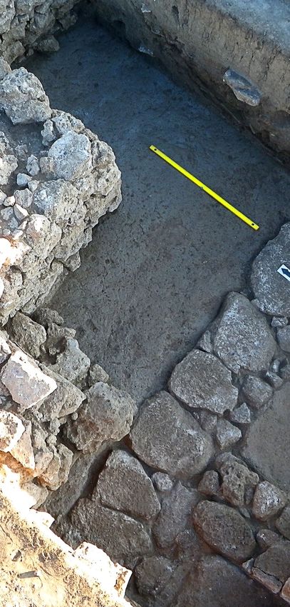
Satellite imagery
                support
Metashape 1.6 features satellite imagery processing in addition to central
perspective cameras such as frame, fisheye, spherical and cylindrical ones,
supported in earlier versions. This option is integrated into the standard work-
flow, allowing to generate all typical products such as dense clouds, DEMs,
orthomosaics and tiled polygonal models, both on a local workstation and
over a network. Panchromatic and multispectral satellite images are supported,
provided that sufficiently accurate RPC data is available for each image.

Laser scanning data can also be loaded into Metashape software and merged
with photogrammetric point cloud; furthermore, LIDAR points can be
colorized with the help of the imagery available for the same scene. In case
project deals with archival data, Metashape is capable of scanned film images
processing with support for automatic fiducial marks detection. If source
data is video sequence, adaptive frame selection based on camera motion
speed is particularly beneficial.
Mission planning

                                                                              Matthias Church by FlyBySense
                for complex sites
Metashape 1.6 enables to automatically calculate optimal mission plans for
objects of complex geometry, like many of the cultural heritage buildings,
based on simple overhead flight. Generated mission plan can be loaded in
a drone controlling application to automatically perform survey session for
detailed model reconstruction.

Reduce overlap feature is made for analyzing excessive image sets to under-
stand which images are useful and which are redundant. This helps to main-
tain balance between processing time and model quality, as well as to get
guidance for future survey missions for the objects of a similar type.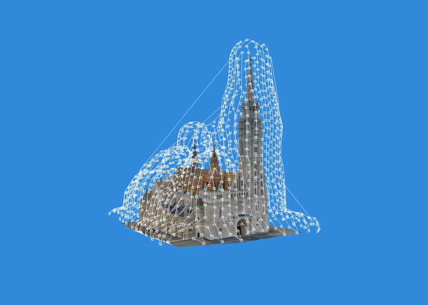
Out-of-core detailed

                                                                                   Superintendent’s office IPHAN by Adolfo Ibañez Vila
                mesh generation
Improved filtering algorithm at dense stereo matching step in Metashape 1.6
helps to reduce noise on the final surface while preserving thin structures
within the scene. New mesh generation method works directly with depth
maps data — this allows to reconstruct exceptionally detailed geometry thanks
to utilization of all the information available. The method is adaptive concern-
ing resolution of the input imagery and, thus, guarantees efficient usage of the
hardware resources while generating the most detailed model possible for the
dataset.

Furthermore, out-of-core implementation greatly reduces memory consump-
tion, while GPU acceleration support for both mesh and texture generation
steps significantly speeds up the processing. Distributed mesh generation over
network allows for further cut of processing time.
Cloud processing
& online visualization
Metashape is optimized for multi-core CPUs and multi-GPU systems for fast
generation of the results on a single machine. Distributed processing on an
HPC cluster helps to speed up all the calculations for massive datasets even
further. Batch processing and integrated Python and Java API options enable
all levels of automation of the photogrammetric processing workflow.
Metashape 1.6 presents improved cloud processing interface allowing to save
on the hardware infrastructure for photogrammetric pipeline, with further
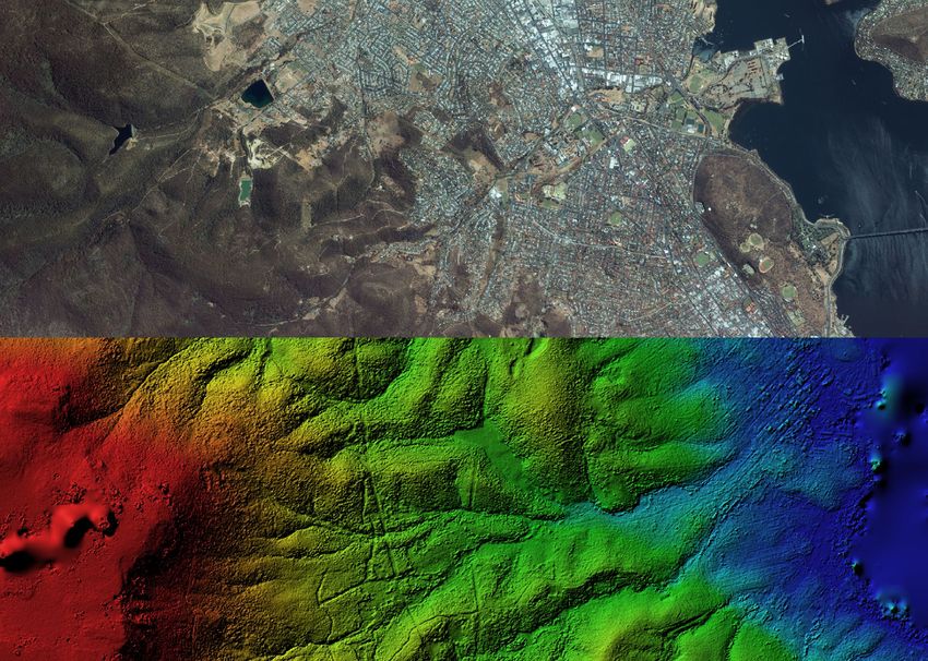
option to visualize processing results online.Seamless orthomosaic for Surveying & Mapping Metashape is a perfect tool for aerial imagery processing. The functionality of the program is being constantly developed according to the tasks set by rapidly emerging UAS industry. Metashape has proved to be a professional level post-processing tool capable of dense point clouds generation and classification for further exceptionally detailed DSMs/DTMs calculations and high-resolution seamless ortho- mosaics export, not to mention reconstruction of precise polygonal models of large scale objects. It is an indispensable part of GIS workflow starting with a UAV system.
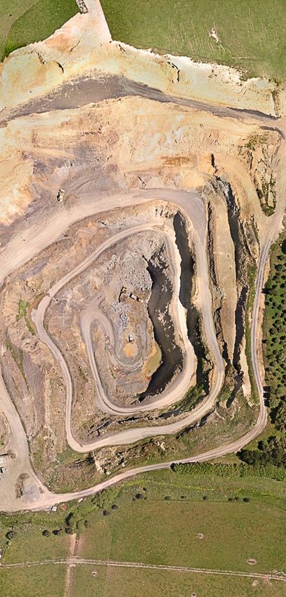
Highly accurate measurements
for Mining & Quarrying
Highly accurate DEMs produced by Metashape lay the grounds for precise
area and volume measurements, both for excavations and piles. Once multiple
flights performed at different time moments, Metashape allows for volume
change tracking, soil erosion and glacier studies.

Automatic non-coded targets detection capability saves up on manual work
in inspection projects done on a regular basis
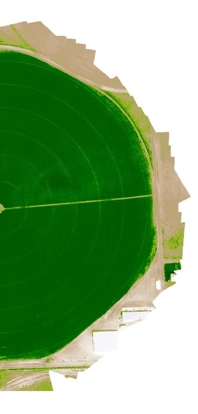
Customized vegetation index calculation
for Precision Agriculture & Environmental
Management
With support for panchromatic, multispectral and thermal imagery, Metashape
seamlessly integrates into workflows involving processing of data from diverse
sources, like vegetation and soil analysis, fires and night studies, etc.

Vegetation indices calculation according to a user-defined formula allows to
analyze crop problems and generate prescriptions for variable rate farming
equipment.
Consumer camera support
for Archaeology & Documentation
Archaeology more and more often relies on photogrammetric approaches
today, be it a need to model an artifact or a demand for an excavation map-
ping.

Thanks to the capability to process imagery from any digital camera, Metashape
is widely used in various archaeological projects both up in the mountains and
deep under the water, including special researches like greenery pattern studies
to find ancient ruins under the ground or rock art documentation and analysis
projects.
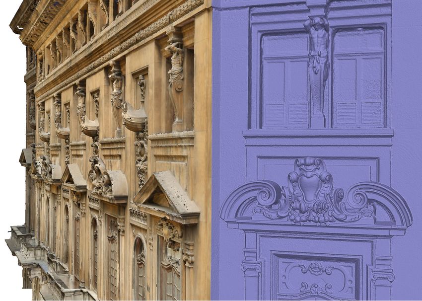
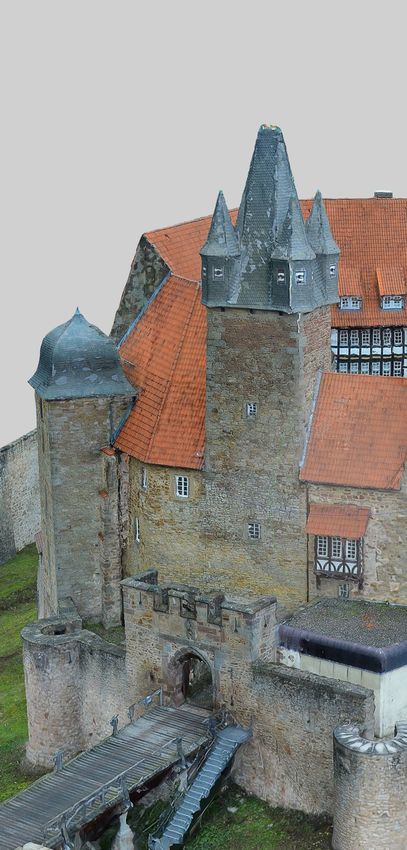
Oblique imagery support
for Architecture & Cultural Heritage
Preservation
Numerous projects prove that Metashape is a quality tool to solve the tasks
of facade and building modeling.

With support for oblique imagery processing, Metashape allows to recon-
struct the whole building, which can be employed for virtual tours creation,
with reconstruction results being exhibited as illustrative models of large-
scale cultural heritage objects. 3D models of partially ruined monuments
and artifacts generated with Metashape present reliable basis for restoration
works thanks to exceptional accuracy of reconstruction results.

Castle Spangenberg by Aibotix GmbH
www.aibotix.com
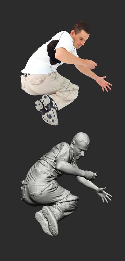
Photorealistic textures
for Visual Effects & Game Design
Thanks to being highly detailed and photorealistic, Metashape models meet
the strict requirements of professional animation studios, which successfully
employ the software for movie and game production.

Face and body capture results, being among the most demanded ones, prove
that Metashape potential goes beyond one’s imagination.

Human scan by Infinite Realities
www.ir-ltd.net
Advantages
01. Highly accurate and detailed     04. Network processing for large      07. Easy sharing with PDF or fly
results                              projects                              through video export and direct
                                                                           upload to online resources
02. Fully automated and intuitive    05. Cloud processing and visuali-
workflow                             zation to save up on infrastructure   08. Stereoscopic measurements for
                                                                           precise feature extraction
03. GPU acceleration for faster      06. Reasonably powerful Standard
processing                           edition for art projects

      Compatibility
01. Processes images from digital/   03. Works well with most UAVs         06. Supports most EPSG coordinate
film/video cameras and multi-                                              systems and configurable vertical
camera systems                       04. Integrates with LIDAR work-       datums
                                     flows with point cloud import
02. Supports frame/fisheye/                                                07. Runs on Windows, Mac OS X
spherical/cylindrical/RPC camera     05. Exports results in widely         and Linux
models                               supported formats
Capabilities
01. Satellite, aerial and close-range 09. Manual seamline editing 16. Ambient occlusion and normal
triangulation maps generation
10. Elevation contour lines
02. Incremental image alignment generation 17. 4D reconstruction for dynamic
scenes
03. Mission planning 11. Georeferencing using flight log
and/or GCPs 18. Hierarchical tiled model gene-
04. Image set redundancy analysis ration and visualization
12. Coded and non-coded targets
05. Dense point cloud generation auto detection 19. Polygonal model reconstruction
and automatic multi-class
classification 13. Coordinate/distance/area/ 20. Spherical panorama stitching
volume measurements
06. DSM/DTM generation 21. Built-in Python scripting and
14. Multispectral imagery processing Java API for job automation
07. True orthomosaic generation in and vegetation index calculation
user defined projections 22. Headless operation support
15. Texture generation with
08. Automatic seamline refinement delighting and deghosting filters
for traditional DTM-based
orthomosaicsWant to try? Start your testing with free 30-day trial license — compare editions and download at www.agisoft.com Register at cloud.agisoft.com and To place an order contact our sales Benefit from the local purchase get personal account to test cloud department sales@agisoft.com — check the list of our authorized processing of your projects resellers at www.agisoft.com 2019 © Agisoft LLC
You can also read