Land Tenure and Its Influence on Agriculture in Artisanal Gold-Mining Zones of Sikasso Region, Mali
←
→
Page content transcription
If your browser does not render page correctly, please read the page content below
Open Journal of Ecology, 2021, 11, 95-104
                                                                                             https://www.scirp.org/journal/oje
                                                                                                        ISSN Online: 2162-1993
                                                                                                          ISSN Print: 2162-1985

Land Tenure and Its Influence on Agriculture in
Artisanal Gold-Mining Zones of Sikasso Region,
Mali

Mahamadou Moussa Keita1,2,3*, George Morara Ogendi2,3
1
 Rural Polytechnic Institute for Training and Applied Research, Katibougou, Koulikoro, Mali
2
 Department of Environmental Science, Egerton University, Njoro Campus, Nakuru, Kenya
3
 Dryland Research Training and Ecotourism Centre, Chemeron, Baringo, Kenya

How to cite this paper: Keita, M.M. and       Abstract
Ogendi, G.M. (2021) Land Tenure and Its
Influence on Agriculture in Artisanal Gold-   Land tenure is a major determinant of the types of land use in a region or
Mining Zones of Sikasso Region, Mali. Open    area and, by extension, affects its conservation. Most of the land that falls
Journal of Ecology, 11, 95-104.
                                              under public or communal land-tenure systems in developing countries such
https://doi.org/10.4236/oje.2021.112009
                                              as Mali faces numerous challenges among them being natural resource overex-
Received: December 14, 2020                   ploitation. This is mainly because the land is openly accessible to all people
Accepted: February 4, 2021                    around it, and thus the tendency to overexploit the land resources leading to
Published: February 7, 2021
                                              degradation, and food and environmental insecurity. In Mali, land ownership
Copyright © 2021 by author(s) and             falls under three categories: Public or Government, Communal and Private.
Scientific Research Publishing Inc.           This study was undertaken to assess the land ownership types in Yanfolia
This work is licensed under the Creative      District, Mali, a gold-mining area that lies some 170 km southern east of cap-
Commons Attribution International
                                              ital district of Bamako and upstream of Selingué dam on Sankarini River. A
License (CC BY 4.0).
http://creativecommons.org/licenses/by/4.0/   social survey of 200 households was done using a structured questionnaire.
                Open Access                   Additional research instruments were focus group discussion, key informant
                                              interviews and observation check-lists. The data was analyzed using both de-
                                              scriptive and inferential statistics. The study findings indicated that most of
                                              the land under gold-mining was owned by the government followed by
                                              community and finally private. There were significant associations between
                                              size of land under gold-mining and land tenure types: communal land (χ2 =
                                              30.52; p = 0.000); private land (χ2 = 65.09; p = 0.000) and public or govern-
                                              ment land (χ2 = 177; p = 0.000). Gold-mining takes place mostly on lands
                                              classified under public/government and communal compared to that which
                                              takes place on lands classified as private. It is recommended that the relevant
                                              Malian governmental regulatory and enforcement agencies implement and
                                              enforce existing environmental laws with respect to land and environment.
                                              These agencies should adopt participatory and sustainable approaches to land

DOI: 10.4236/oje.2021.112009 Feb. 7, 2021                       95                                     Open Journal of Ecology
M. M. Keita, G. M. Ogendi
and natural resources management for improved food and environmental
security.
Keywords
Land, Gold-Mining, Environment, Agriculture, Food-Security
1. Introduction
Land use as a common natural resource has jeopardized environmental security
and property right in developing countries [1]. Artisanal gold-mining contributes
to raising land ownership problems in Mali. Majority of artisanal gold-mining is
exploited as common resources under the property right of community. Land
right is declining to be for government generally in Mali [2] [3]. Indeed, there
are two other property rights which include community and private. In fact, ar-
tisanal gold mining exploitation is under community right in term of common
resources in this country. There is an exploitation type called “draguage” (exca-
vator system) which is used by private firms contracted privately by the govern-
ment of Mali. These private firms exploit gold directly on rivers and backwaters
with government licenses or authorization over the country. Land monitoring in
Mali is carried out by three types of right. The first right is for government
which includes all in the territory of country, aspects of defense, and questions
linked to boundaries and community conflict. The second right is about the tra-
ditional laws and rights of communities. These are usually called accustomed
laws and rights. In other words, they are first occupants, habitants and comers at
the place. Ordinarily, these rights and laws are followed up and monitored by
traditional chief of villages, sub-counties and counties undertaking the govern-
ment right. This study was undertaken to assess the land ownership types of ar-
tisanal gold mining area of Farabacoura, Yanfolia District in Mali.
2. Materials and Methods
2.1. Study Area
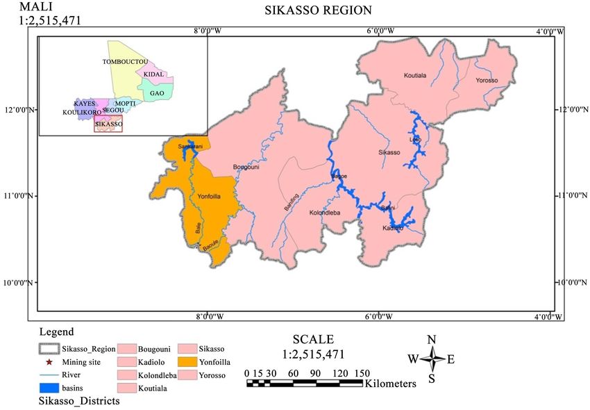
Sikasso region is located in the Southern part of Mali and it is also the third ad-
ministrative region of the country. It borders Segou region to the North, Repub-
lic of Cote d’Ivoire in the South, Republic of Guinea to the West, Burkina Faso
to the East and Koulikoro region to the North West. Sikasso region covers
71.790 km2 representing 3.8% of national territory. The region has seven (7) dis-
tricts which include Sikasso, Bougouni, Kadiolo, Kolondièba, Koutiala, Yanfolila
and Yorosso. In Sikasso region, there are 3 urban communes, 144 rural com-
munes and 1.831 villages [4].
Farabacoura and Tiéguècourouni are villages in Tangandougou commune,
district of Yanfolila in Sikasso region. Tangandougou commune is some 170 km
from Bamako, the capital city of Mali. The study sites, Farabacoura are about 10
DOI: 10.4236/oje.2021.112009 96 Open Journal of EcologyM. M. Keita, G. M. Ogendi
km from Selingué Dam which is on Sankarani River while Tiéguècourouni is 55
km away from Selingué. The population of the commune is about 5775 inhabi-
tants [5]. The major ethnic groups of the natives are composed of Bambara, Se-
nufo, Manliké, Bozo and Peulh (Figure 1).
The economic activities of the commune include crop and livestock produc-
tion, fishing, agroforestry, commerce and artisanal gold-mining. These produc-
tion systems are characterized by small-scale farming with low agricultural pro-
duction. In term of cereals production, these small-scale farmers cultivate maize,
sorghum and millet for subsistence purposes. The commercial crops include
rice, cotton, groundnut and sweet-potatoes.
Livestock production is based both on extensive system for commercial pur-
poses and traditional practices for the provision of households needs and to
supply crop production with composting manure and other activities in farm.
The main types of livestock reared comprise cows, goats, sheep, donkeys and
chickens. They are only reared for subsistence purposes and for other domestic
expenditures such as health care and for traditional ceremonies like marriages,
burial and other rites of passages.
In term of forest and environmental management, the natives practice agro-
forestry activities mainly focused on both indigenous and exotic trees. The ex-
ploitation of the indigenous plants such as karité, néré, baobao, Afzelia africana,
Khaya senegalensis and Prosopis africana is for food production, precious wood
and medicinal purposes. The communities also grow fruits trees such as orange,
mango and papaya among others where they supply the local markets with fruits
as a source of income apart from supplementing their diets.
Figure 1. Location of study area in Sikasso region.
DOI: 10.4236/oje.2021.112009 97 Open Journal of EcologyM. M. Keita, G. M. Ogendi
2.2. Assumption of System Theory
The system theory stands for ecosystem and socio-system in term of entities’ re-
lationships. The ecosystem has to ensure interacting functional unit in living and
non-living environment while socio-system refers to humans’ functional unit ex-
ploiting resources for their lives, they are supposed to protect and improve them
from destruction state. The imbalance between entities in their functional units
will drive to climate change in environment, society and economic activities.
Consequently, the imbalances of entities will impact sustainable development
logical process to be realized in multidimensional context [6]. The approach fo-
cuses on the system model of Drivers-Pressures-State-Exposure-Effects-Actions
(DPSEEA) inspired from Drivers, Pressures, State, Impacts, Responses (DPSIR)
[7] [8].
2.3. Data Collection Tools and Methods
Structured questionnaires were used to gather information from the household
head or his/her representative. The questionnaires were structured on profes-
sions (gold mining, crop, livestock, agroforestry, fisheries, age, gender, origin,
marital status, education level, etc.). In addition, three focus group discussions
were held with local government, miners and non-miners in Tangandougou
Commune plus key informant interviews and observation check-list. The col-
lected data was analysed using the Statistic Package for Social Sciences (SPSS)
while ArcGIS was used for geographical information to come up with study area
Map.
The sampling technique that was employed in this study considered artisanal
gold mining as a factor that caused impacts on social economic functions of the
natives of Sikasso region. Data was collected by the use of structured question-
naire which was administered through interviewing the households’ heads. In
each case one representative of the household who was 18 years old was inter-
viewed. The sample size was 200 households consisting of respondents drawn
from the study area and had some information about artisanal gold mining and
impacts on the social economic systems. The questionnaires were administered
in Farabacoura and Tieguecourouni villages both in Tangandougou Commune,
of Yanfolila district.
The respondents were drawn from the two villages equally as follows:
The mining site: Farabacoura village respondents represented the mining
site. These respondents were involved in either mining and/or agricultural
activities. The information on these activities was collected from an area of
approximately 20 km2.
The non-mining site: as a nearby site of Tieguecourouni village, the study in-
terviewed 100 households by soliciting information about mining and agri-
cultural activities based on study objectives. The distance between the two
study villages was approximately 45 km but within the same commune.
The sample for this study was calculated using the formula indicated here be-
DOI: 10.4236/oje.2021.112009 98 Open Journal of EcologyM. M. Keita, G. M. Ogendi
low [9]. The study was used this formula, because the population of Tangan-
dougou commune is ready known.
NC 2
n= (1)
C 2 + ( N − 1) e 2
where:
n = is the sample size
N = is the known population of Tangandougou commune
e = is the error margin of (3%)
C = is the coefficient of variation (30%)
The sample size based on this formula was:
5775 × 0.32
=n = 100 (2)
0.3 + ( 5775 − 1) 0.03
2 2
The result was multiplied by two giving a total of 200 households distributed
as 50% between the two villages for data collection in Tangandougou commune.
The study used exploratory and descriptive research designs with cross sec-
tional random sampling of 200 households. Data collection was done using
household survey in Farabacoura and Tiéguècourouni. The questionnaires were
administered on mining site of Farabacoura and non-mining site of Tiéguècou-
rouni. This study sites were approximately 50 km apart. The proportionality of
100 samples was used for household survey as sample size on each site. Data was
analysed using descriptive and inferential statistics such as Chi-square, correla-
tion and logit model computed with location as dependent variable. According
to [10], “the model is defined as logistic if the expression for the probability fac-
tors given the Xs, is 1 over 1 plus e to minus the quantity α plus the sum from i
equals 1 to K of βi times Xi” the formula bellow defined mathematically Logistic
Regression model.
1
P( X ) = − (α + ∑ β i X i )
(3)
1+ e
where P(X) stands for location, α and βi represented in the model formula are
unknown parameters which have to be estimated from data collected on Xs and
D for a group of study subjects [10]. In this case study, the binary variables were
used and codified as no or yes which are equal to (0, 1).
3. Results
3.1. Descriptive of Land Ownership in Artisanal Gold-Mining
The community land property right was observed in 167 households representing
around 83.5% of study population. Those who were not working on community
land were 33 respondents representing 16.5% of the interviewed people. The
distribution was 69 positive responses from the non-mining site and 98 from the
mining site. The negative responses were 31 from the non-mining site and 2
from mining site. The Chi-Square was (χ2 = 30.52) with the significance level of
(p = 0.000) (Table 1).
DOI: 10.4236/oje.2021.112009 99 Open Journal of EcologyM. M. Keita, G. M. Ogendi
Table 1. Frequency and percentage of types of land in non-mining and mining areas.
N = 200
Parameters Freq. % χ2 p
Non-Mining Mining
Community right
No 33 16.5 31 2
30.521 0.000
Yes 167 83.5 69 98
Private
No 137 68.5 42 95
65.091 0.000
Yes 63 31.5 58 5
Government
No 104 52 99 5
177.003 0.000
Yes 96 48 1 95
Source: Authors’ Field Survey, 2016.
The private right of land was quoted in 63 interviewed households represented
by 31.5% of respondents’ population. They were 137 households represented by
68.5% in which private right of land was not quoted among study population.
That population was distributed as 58 from the non-mining site and 5 people
from the mining site who gave the positive responses. The negative responses
were 42 from the non-mining site and 95 from the mining site among observed
population. The Chi-Square was (χ2 = 65.09) with the significance level of (p =
0.000).
The public or government right was observed in 96 interviewed households
represented by 48% of the respondents’ population. There were 104 interviewed
households represented by 52% in which people did not recognize the public
right. The distribution was 1 observed from the non-mining site and 95 from the
mining site gave positive responses There were 99 from the non-mining site and
5 from the mining site who quoted the negative responses. The Chi-Square was
(χ2 = 177.00) with the significance level of (p = 0.000).
3.2. Correlation of Land Property Right
The correlation of land property right included community right, private right,
government or public right and about location. Results showed that there were
significant strong negative relationships between private right and location (r =
−0.57; p > 0.01), private right and community right (r = −0.65; p > 0.01) and
between government versus private right (r = −0.60; p > 0.01). In addition, there
were significant strong positive relationships between community right and lo-
cation (r = 0.39; p > 0.01), government right and location (r = 0.94; p > 0.01) and
between government versus community right (r = 0.40; p > 0.01) (Table 2).
3.3. Logit Regression of Land Property Right
Land right is declining to be under the control of the government generally in
DOI: 10.4236/oje.2021.112009 100 Open Journal of EcologyM. M. Keita, G. M. Ogendi
Table 2. Pearson’s correlations of land property right.
Parameters Location Community right Private right Government right
Location 1
Community right 0.391** 1
Private right −0.570** −0.656** 1
Government/
0.941** 0.400** −0.608** 1
Public right
**. Correlation is significant at the 0.01 level (2-tailed). Source: Authors’ Field Survey 2016.
Mali (Constitution, 1992). Indeed, there are two other property rights which in-
clude community and private. Artisanal gold-mining is exploited under com-
munity right in term of common resources in this country. There is a type of ex-
ploitation called “draguage” (excavator system) which is carried out by con-
tracted private companies with partnership of the government of Mali. These
private companies are exploiting gold directly on rivers with government li-
censes or authorization over the country.
Land is monitored by three types of right in Republic of Mali. The first right is
from the government which includes all the territory of country, all aspects of
defense, questions linked to boundaries and community conflict. The second is
about the traditional laws and rights of communities. These are usually called
accustomed laws and rights. In other words, they are first occupants, habitants,
comers at the place. Ordinarily, these rights and laws are followed-up and mo-
nitored by the traditional chief of villages, sub-counties and counties undertak-
ing the government right (Table 3).
The parameters run about the property right looked at the ownership of land
used on gold-mining and non-mining sites. These were attributed to community
right, private right and government or public right of land. They all had a posi-
tive strong correlation to localities with the coefficient of community right
(0.819), private right (0.433) and government right (7.587). If
Y =β 0 + β X 1 + β X 2 + β X 3 + ε so the variables in equation were
Y= 4.988 .
−3.851 + 0.819 + 0.433 + 7.587 =
4. Discussions
There are three major types of land currently in Mali. The significant characte-
ristic is that government owns all the land over the country in term of adminis-
tration. By doing so, it becomes the principal regulator of all issues related to
land [11]. The government is currently on land identification concerning farm
lands in Mali. In addition, there are also private and community property rights
of land that means individual or communities can get property right of land in
Mali. According to [12] land certification is a fundamental issue of stability, it
increases households income and reduces conflict [13]. Land conflict becomes
increased where policies are not clear [14] [15].
DOI: 10.4236/oje.2021.112009 101 Open Journal of EcologyM. M. Keita, G. M. Ogendi
Table 3. Logit regression of land tenure in tangandougou commune.
Explanatory Variables B S.E. Wald Sig.
Community right 0.819 1.239 0.437 0.509
Private right 0.433 1.027 0.178 0.673
Government 7.587 1.230 38.061 0.000***
Constant −3.851 1.439 7.161 0.007
*** significant at 1% level. Source: Authors’ Field Survey, 2016.
4.1. Public/Government Land
In the case of public land, the rights belong to the government and it is the larg-
est flexible ownership. Globally, this right covers all territory of the country in-
cluding parks, lakes, rivers, forests, swamp and dry land. The government is the
regulator and controller of land under this right. These lands are notified with
landed title and classification order so as to protect them such as forests, sensibly
lands, army land and other protected areas [16]. These public lands have to be
reclassified only by political and national interest issues [17]. According to [18]
the estimation of world’s forests are about 80 percent are publicly owned with
the remaining held by local communities and municipalities.
4.2. Private Land
In case of private land, they are three kinds of documents which allowed people
to own land. These documents are essentially the letter, permit and land title.
The letter and permit cannot give all right of ownership while fundamental title
gives all right of ownership including exploitation of natural resources. The let-
ter and permit are temporary authorization given to owners by authorities. This
ownership will be released whenever the government projects are undertaken for
the same the land [19].
4.3. Community Land
Land under control of the community, the comminatory land is for everybody
and it will fail into the “Tragedy of commons”. The property right is neither for
anybody nor notified and identified by any official document. Nevertheless, ac-
cording to the constitution of 1992, people can exploit community land for
agricultural purposes, animals grazing and housing in rural areas. Land becomes
overexploited and degraded by community such us overfishing, forests degrada-
tion and deforestation [20] [21].
5. Conclusion & Recommendations
The study concluded that the cultivable lands were negatively affected by arti-
sanal gold-mining because of absence of property right in this area. Therefore,
the government should identify and certify by sectors all lands over the territory
of Mali. The certification will correct the insufficiency of land management and
prevents conflict in rural areas.
DOI: 10.4236/oje.2021.112009 102 Open Journal of EcologyM. M. Keita, G. M. Ogendi
Acknowledgements
This material is based upon work supported by the United States Agency for In-
ternational Development, as part of the Feed the Future initiative, under the
CGIAR Fund, award number BFS-G-11-00002, and the predecessor fund the
Fond Security and Crisis Mitigation II grant, award number EEM-G-00-04-00013.
Conflicts of Interest
The authors declare no conflicts of interest regarding the publication of this pa-
per.
References
[1] Hardin, G. (1968) The Tragedy of the Commons. Science, 162, 1243-1248.
https://doi.org/10.1126/science.162.3859.1243
[2] Republic of Mali (1992) Constitution: Presidency of the Republic of Mali.
[3] Nurbekov, A., Akramkhanov, A., Kassam, A., Sydyk, D., Ziyadoullaev, Z. and La-
mers, J.P.A. (2016) Conservation Agriculture for Combating Land Degradation in
Central Asia: A Synthesis. AIMS Agriculture and Food, 1, 144-156.
https://doi.org/10.3934/agrfood.2016.2.144
http://www.aimspress.com/journal/agriculture
[4] Assemblée Régionale de Sikasso (2011) Plan stratégique de développement régional
de Sikasso 2011-2020. ARS/Fonds Africain pour le Développement, Abidjan.
[5] RGPH (2009) Récensement General de la Population et de l’Habitat du Mali
(RGPH) Résultats définitifs. Répertoire des villages, Sikasso.
[6] Mele, C., Pels, J. and Polese, F. (2010) A Brief Review of Systems Theories and Their
Managerial Applications Service Science, 2, 126-135.
https://doi.org/10.1287/serv.2.1_2.126
[7] Abdelrehim, A., Ghali, C., Akol, C., Ambala, C., Mafuta, C., Sebukeera, C., Turya-
tunga, F., Lungu, I.G., Ndione, J.A., Opio-Odongo, J., Sabet, M., Daoud, M., and
Ochola, W. (2011) Africa Environment Outlook-3, Authors’ Guide. United Nations
Environment Programme, Nairobi.
[8] Kleinbaum, D.G. and Klein, M. (2010) Logistic Regression: A Self-Learning Text.
3rd Edition, Springer, New York. https://doi.org/10.1007/978-1-4419-1742-3
[9] Nassiuma, D. (2000) Survey Sampling: Theory and Methods. Nairobi University
Press, Nairobi, 7.
[10] Iannucci, C., Munajo, M. and Sambucini, V. (2011) A System Approach to the In-
tegration of Ecosystem Services with DPSIR Components. Shaker Verlag Aachen.
[11] United States Agency for International Development (2010) Mali Land Tenure As-
sessment Report. http://www.usaid.gov
[12] Persha, L., Mattingly, D., Greif, A. and Huntington, H. (2014) Impact Evaluation of
Land Certification Project in Ethiopia.
https://www.land-links.org/wp-content/uploads/2016/09/USAID_Land_Tenure_EL
TAPELAP_IE_Overview_Updated.pdf
[13] Diallo, D. (2014) Properties and Management of Gravelly Soils Developed on Fer-
ruginous Cuirass in Mali. Journal of Soil Science and Environmental Management,
6, 35-43. https://doi.org/10.5897/JSSEM12.084
[14] Jayne, T., Stevens, C., Lowery, S. and Stickler, M. (2016) The Role of Land Policy in
DOI: 10.4236/oje.2021.112009 103 Open Journal of EcologyM. M. Keita, G. M. Ogendi
Agricultural Transformation and Inclusive Economic Growth: Implications for
Africa. World Bank, Washington DC.
[15] Kloos, K., McClung, M. and Huang, S. (2016) Insights from Rwanda: Analysis of
Land Conflict Resolution Project in Eastern Province. World Bank, Washington
DC.
[16] Barthel, K., Cespedes, V., Salazar, B., Torres, R. and Varon, M. (2016) Land and
Rural Development Policy Reforms in Colombia: The Path to Peace. World Bank,
Washington DC.
[17] Keita, M.M., Ogendi, G.M., Owuor, G. and Wycliff, N.N. (2018) Impacts of Arti-
sanal Gold Mining on Water Quality: A Case Study of Tangandougou Commune in
Sikasso Region, Mali. Journal of Environmental Health and Sustainable Develop-
ment, 3, 621-629. http://dx.doi.org/10.18502/jehsd.v3i4.228
[18] Aggarwal, S. and Freudenberger, M.S. (2013) Tenure, Governance, and Natural Re-
source Management, Contributions to USAID Development Objectives.
http://usaidlandtenure.net/
[19] Keita, M.M., Ogendi, G.M. and Owuor, G. (2018) Socio-economic Factors That In-
fluence Household Incomes in Artisanal Gold Mining Area of Tangandougou
Commune, Mali. ADRRI Journal of Agriculture and Food Sciences, 4, 1-19.
[20] Awgichew, S., Flintan, F. and Bekure, S. (2016) Improving Security of Rights to Re-
sources through Participatory Rangeland Management in Ethiopia. World Bank,
Washington DC.
[21] Keita, M.M., Owuor, G. and Ogendi, G.M. (2018) Drivers of Participation in Arti-
sanal Gold Mining and Its Effect on Agriculture in Mali. ADRRI Journal of Agri-
culture and Food Sciences, 4, 1-16.
DOI: 10.4236/oje.2021.112009 104 Open Journal of EcologyYou can also read