Landforms and Landscapes - 16 ARTICLES 16 IMAGES 7 VIDEOS For Years 6-8 This Pack contains: Humanities and Social Sciences ...
←
→
Page content transcription
If your browser does not render page correctly, please read the page content below
Britannica LaunchPacks | Landforms and Landscapes

                    Landforms and Landscapes
                                                 For Years 6-8

                This Pack contains:

                                               16 ARTICLES
                                               16 IMAGES
                                               7 VIDEOS

© 2020 Encyclopædia Britannica, Inc.                             1 of 90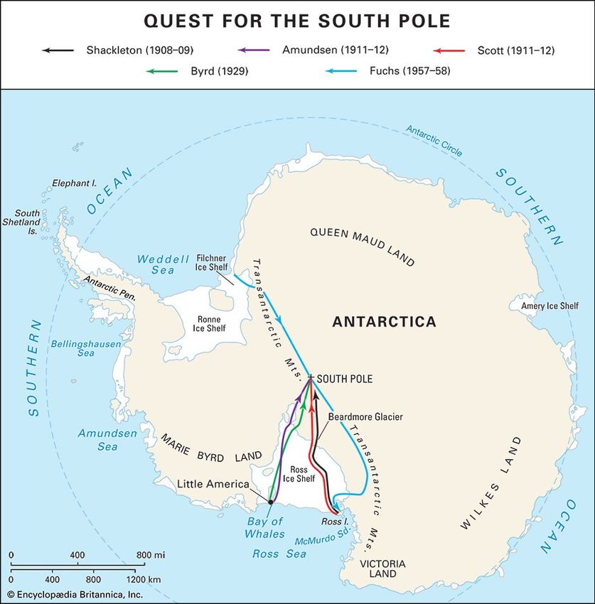
Britannica LaunchPacks | Landforms and Landscapes

 Antarctica
 The icy continent surrounding the South Pole is called Antarctica. Its name means “opposite to the Arctic,”
 referring to the region around the North Pole. Antarctica is the fifth in size among the continents, larger than
 Europe and Australia. It is a cold and forbidding land that has no permanent human population and is almost
 devoid of animal or plant life. However, the ocean surrounding Antarctica teems with life.

 A map of Antarctica highlights the major geographic regions, ice sheets, and research stations (with …

 Encyclopædia Britannica, Inc.

 Gentoo penguins live in Antarctica.

 Paul Souders—Stone/Getty Images

© 2020 Encyclopædia Britannica, Inc.                                                                                2 of 90
Britannica LaunchPacks | Landforms and Landscapes

 Researchers study the Ross Ice Shelf at the Bay of Whales, Antarctica.

 Michael Van Woert/NOAA NESDIS, ORA

 Ice and stormy seas kept anyone from seeing Antarctica until about 1820. In 1950 more than half the continent
 still had not been seen. Now airplanes and tractors have taken people to most parts of Antarctica, and satellite
 photographs have revealed the rest. But Antarctica remains a frontier, and much is yet to be learned about it.

 Almost no one goes to Antarctica except scientists and some adventurous tourists. The continent has natural
 resources that someday may be used, but the harsh environment of the area makes them difficult to exploit.
 Countries interested in Antarctica have signed a treaty that reserves the region for science and other peaceful
 purposes.

© 2020 Encyclopædia Britannica, Inc.                                                                              3 of 90
Britannica LaunchPacks | Landforms and Landscapes

 The Land

 Paradise Bay is a harbor on the Antarctic Peninsula.

 © Jupiterimages—Photos.com/Getty Images

 Antarctica covers an area of about 5.5 million square miles (14.2 million square kilometers). It would be
 essentially circular except for the Antarctic Peninsula and two indentations created by the Ross Sea and the
 Weddell Sea. The Antarctic Peninsula forms an 800-mile (1,300-kilometer) northward extension of Antarctica
 toward the southern tip of South America, about 600 miles (970 kilometers) away.

 The enormous Beardmore Glacier extends across the Transantarctic Mountains of central Antarctica.

 Commander Jim Waldron USNR—Antarctic Photo Library/National Science Foundation

 An ice sheet covers nearly all of Antarctica. At its thickest point the ice sheet is 15,670 feet (4,776 meters)
 deep—almost 3 miles (5 kilometers). It averages 7,000 to 8,000 feet (2,100 to 2,400 meters) thick, making
 Antarctica the continent with the highest mean elevation. This ice sheet contains 90 percent of the world’s ice
 and 70 percent of the world’s fresh water.

© 2020 Encyclopædia Britannica, Inc.                                                                               4 of 90
Britannica LaunchPacks | Landforms and Landscapes

 An iceberg floats in the waters off Antarctica.

 iStockphoto/Thinkstock

 This picture shows the edge of an ice shelf in Antarctica. An ice shelf is a thick mass of floating…

 © Armin Rose/Shutterstock.com

 The Antarctic ice was formed from the snows of millions of years that fell on the land, layer on layer. The weight
 of new snow squeezes the old snow underneath until it turns to a substance called firn, then ice. As the ice piles
 up, it moves toward the coast like batter spreading in a pan. The moving ice forms into glaciers, rivers of ice that
 flow into the sea. Pieces of the floating glaciers break off from time to time, a process called calving. These
 icebergs float north until they reach warm water, break into pieces, and melt. Icebergs as large as 40 by 30
 miles (64 by 48 kilometers) have been sighted, but most are smaller. In some places the floating glaciers stay
 attached to the land and continue to grow until they become ice shelves. The Ross Ice Shelf alone is about the
 size of Canada’s Yukon Territory and averages 1,100 feet (330 meters) thick.

 The Transantarctic Mountains divide Antarctica into eastern and western parts. The mountains stretch …

 Hannes Grobe

© 2020 Encyclopædia Britannica, Inc.                                                                               5 of 90
Britannica LaunchPacks | Landforms and Landscapes

 The Transantarctic Mountains extend for more than 2,000 miles (3,200 kilometers) across the continent, dividing
 the ice sheet into two parts. The larger, eastern part—called East Antarctica—rests on land that is mostly above
 sea level. It has been there at least 14 million years. The smaller, western part—called West Antarctica—is on
 land that is mostly below sea level.

 Other mountain ranges include the Prince Charles Mountains and smaller groups near the coasts. The Antarctic
 Peninsula has many mountains. The Ellsworth Mountains are Antarctica’s highest, the Vinson Massif rising
 16,050 feet (4,892 meters) above sea level. Mountains with only their peaks showing through the ice (called
 nunataks) are found in some areas. Several active volcanoes on the continent provide spectacular and scenic
 landforms at many places and are located near the Antarctic Peninsula and in the Transantarctic Mountains.

 Only about 2 percent of Antarctica is free from ice. These unusual land areas, called oases, generally are near
 the coast and include the dry valleys of southern Victoria Land and the Bunger Oasis in Wilkes Land. High rims at
 the end of the valleys prevent entry of large glaciers. The warm local climate melts the ends of smaller glaciers
 extending into the valleys.

 In October 2016, 24 countries and the European Union agreed to establish the world's largest marine…

 © Behind the News

 Surrounding Antarctica is a cold water mass called the Southern, or Antarctic, Ocean. It contains what were once
 considered the southern parts of the Pacific, the Atlantic, and the Indian oceans. The Ross and Weddell seas are
 extensions of the Southern Ocean. The Antarctic Convergence, which encircles Antarctica roughly 1,000 miles
 (1,600 kilometers) off the coast, divides the cold southern water mass from warmer waters to the north. The
 Antarctic Circumpolar Current, the world’s largest ocean current, moves eastward around the continent at an
 average speed of about half a knot (1 kilometer per hour). Sea ice up to 10 feet (3 meters) thick forms outward
 from the continent every winter, making a belt 300 to 1,000 miles (500 to 1,600 kilometers) wide. Even in
 summer the sea ice belt is 100 to 500 miles (160 to 800 kilometers) wide in most places.

 The aurora australis, or southern lights, glow in the skies over Antarctica in winter.

 © AbleStock.com/Jupiterimages

© 2020 Encyclopædia Britannica, Inc.                                                                               6 of 90
Britannica LaunchPacks | Landforms and Landscapes

 Antarctica has three points that are called South Poles. The best known is the geographic South Pole, at 90° S
 latitude on the axis of Earth’s rotation. In the early 1990s the geomagnetic South Pole, which moves, was
 located at about 78° S, 108° E, in East Antarctica; it is the center of the Southern Hemisphere auroras. The
 magnetic South Pole is the area toward which compasses point; it is just off the Adélie Coast at about 66° S,
 139° E, and moves a few miles to the northwest each year.

 Antarctica does not have 24-hour periods broken into days and nights. This is because the continent lies almost
 entirely south of the line of latitude of 66.5° S, which is known as the Antarctic Circle. Because of the tilt of Earth’
 s axis as it revolves around the Sun, the Antarctic Circle has one day each year when the Sun does not set (the
 summer solstice, December 21 or 22) and one day when the Sun does not rise (the winter solstice, June 21 or
 22). The number of days without sunset or sunrise increases southward from the Antarctic Circle. At the South
 Pole the Sun rises on about September 21 and moves in a circular path upward until December 21, when it
 reaches about 23.5° above the horizon. Then it circles downward until it sets on about March 22. This “day,” or
 summer, is six months long. From March 22 until September 21 the South Pole is dark, and Antarctica has its
 long “night,” or winter.

 According to scientific theory, some 200 million years ago Antarctica was joined to South America, Africa, India,
 and Australia in a single large continent called Gondwana. There was no ice sheet, and trees and large animals
 flourished. Today, only geological formations, coal beds, and fossils remain as clues to Antarctica’s warm past.

 Climate
 Antarctica is the coldest continent. The world’s record low temperature of –128.6 °F (–89.2 °C) was recorded
 there. The mean annual temperature of the interior is –70 °F (–57 °C). The coast is warmer. Monthly mean
 temperatures at McMurdo Station range from –18° F (–28 °C) in August to 27 °F (–3 °C) in January. Along the
 Antarctic Peninsula temperatures have been as high as 59 ° F (15 °C).

 A person walks in the wind at a camp in Antarctica.

 FLPA/SuperStock

 Because it is such a large area of extreme cold, Antarctica plays an important role in global atmospheric
 circulation. In the tropics the Sun warms the air, causing it to rise and move toward the poles. When these air
 masses arrive over Antarctica, they cool, become heavier, and fall from the high interior of the continent toward
 the sea, making some Antarctic coasts the windiest places in the world. Winds on the Adélie Coast in the winter
 of 1912 to 1913 averaged 40 miles (64 kilometers) per hour 64 percent of the time, and gusts of nearly 200
 miles (320 kilometers) per hour have been recorded.

© 2020 Encyclopædia Britannica, Inc.                                                                                 7 of 90

Britannica LaunchPacks | Landforms and Landscapes

 Antarctica’s interior is one of the world’s major cold deserts. Precipitation (if melted) averages only 1 to 2 inches
 (2.5 to 5 centimeters) a year.

 Plant and Animal Life

 Antarctic hair grass (Deschampsia antarctica) is one of only two flowering plants that grow in…

 Lomvi2

 The severe climate has kept Antarctica nearly devoid of life. Plants are limited almost entirely to primitive types
 that are capable of surviving lengthy winter periods of total or near-total darkness during which photosynthesis
 cannot take place. The most common plants are lichens, which comprise about 350 species. Mosses and
 liverworts grow mostly in ice-free areas along the coast. Two species of flowering plants—a grass and an herb—
 are found on the peninsula and a few islands. More widespread than plants are numerous types of bacteria,
 algae, and fungi such as yeasts and molds.

 The native land animals are limited to arthropods (such as insects), which become inactive during the coldest
 months. Nearly all the species are found only in Antarctica. These springtails, midges, mites, lice, and fleas live
 generally along the coast among plant colonies. Some species live as parasites on birds and seals.

 The immense numbers of birds and seals that live in Antarctica are, properly speaking, sea animals. They spend
 most of their time in or over the water, where they get their food. These animals come ashore only to establish
 rookeries and breed.

 Emperor penguins can be found around the entire coastline of Antarctica.

 © Photos.com/Jupiterimages

© 2020 Encyclopædia Britannica, Inc.                                                                               8 of 90
Britannica LaunchPacks | Landforms and Landscapes

 About 45 species of birds live south of the Antarctic Convergence. Two penguin species—the emperor and the
 Adélie—are distributed widely around the entire coastline. Gentoo and chinstrap penguins occupy Antarctic
 Peninsula coasts and some islands. Penguins are excellent swimmers and catch and eat their food—mostly krill
 (a shrimplike animal) and fishes—underwater.

 The animal life of Antarctica includes Adélie penguins and leopard seals.

 Stockbyte/Thinkstock

 Sea mammals native to Antarctica include seals, porpoises, dolphins, and whales. Four species of seals breed
 almost exclusively in the Antarctic. They are the Weddell seal, which ranges as far south as the sea does and
 can dive as deep as 2,000 feet (600 meters) for nearly an hour; the crabeater seal, which spends most of its
 time around pack ice (sea ice); the leopard seal, which favors penguins as its food; and the Ross seal, rarely
 seen. Other Antarctic species include the fur seal and the huge elephant seal. Most populous is the crabeater,
 whose numbers are estimated to be in the millions. Among the whales of Antarctic waters are the killer whale,
 sperm whale, and rare bottle-nosed, or beaked, whale.

 A marine biologist examines specimens hauled up from the depths of the Southern (Antarctic) Ocean,…

 Contunico © ZDF Enterprises GmbH, Mainz

 Fishes peculiar to the Antarctic include the Antarctic cod and the icefish. These and other Antarctic fish have
 developed blood that enables them to live in seawater as cold as 28 ° F (–2 °C).

© 2020 Encyclopædia Britannica, Inc.                                                                               9 of 90
Britannica LaunchPacks | Landforms and Landscapes

 Antarctic krill (Euphausia superba).

 Matt Wilson/Jay Clark/NOAA NMFS AFSC

 The most important single member of the Antarctic marine food chain is the krill. This crustacean looks like a
 small shrimp and exists in huge numbers; one vast swarm stretching several miles in length was observed from
 ships, and some biologists think the total population may be 5 billion tons or more. Krill eat small marine
 organisms called plankton and in turn are eaten in great numbers by squid, birds, seals, and whales.

 Economic Development
 Antarctica is so far from world markets, and its environment is so hostile, that little economic development has
 taken place. Also, little is known about the amounts of natural resources that exist there. But, if world shortages
 of food and energy products become severe, Antarctica may be more intensely explored. Because no one
 country governs the land, however, exploitation of the continent’s resources would raise questions of ownership.
 In addition, economic development would be limited by the Antarctic Treaty of 1959, which preserved the
 continent for scientific research, as well as later international agreements designed to protect its resources.

 The first people to make money by going to Antarctica were whalers and sealers. Seal hunters began catching
 Antarctic seals for their oil and fur in the late 1700s. Fur seals were reduced almost to extinction by the 1820s,
 at which point the sealers started hunting elephant seals. The hunting of elephant seals continued until 1964,
 when some 20 countries signed measures to protect the plants and animals of Antarctica. The Convention for
 the Conservation of Antarctic Seals, signed in 1972, established guidelines for any future sealing. It prohibits the
 taking of fur, elephant, and Ross seals and limits the annual catch of crabeater, leopard, and Weddell seals.

 Whaling began in Antarctic waters in the 19th century. The industry enlarged greatly in the early 1900s, when
 steamships, harpoon guns, and shore processing stations (notably at South Georgia) were introduced. During the
 1912–13 season 10,760 whales were caught. After that time nearly all the whales caught in the world were
 caught in Antarctic waters. In 1931, a peak year, 40,199 whales were caught in the Antarctic, while only 1,124
 were caught in the rest of the world. So many whales were caught that their numbers declined, just as had those
 of the seals. The industry declined after 1960. In the 1980–81 season fewer than 6,000 whales were caught in
 the Antarctic; all were minke whales, a relatively small-sized species also called the lesser rorqual. In 1986 the
 International Whaling Commission banned commercial whaling, though Japan continues to take Antarctic whales
 in the name of scientific research.

 The Soviet Union began commercial fishing on a large scale in 1967. Within a decade, intensive fishing led to
 severe declines in the numbers of Antarctic cod and other types of fish. Krill fishing began in the early 1970s and
 grew rapidly over the next decade. In response to these threats to the Antarctic ecosystem, multiple countries
 signed the Convention on the Conservation of Antarctic Marine Living Resources in 1982. This agreement—an

© 2020 Encyclopædia Britannica, Inc.                                                                               10 of 90
Britannica LaunchPacks | Landforms and Landscapes

 addition to the Antarctic Treaty—set catch limits on krill, finfish, and other marine animals. After a period of
 decline, krill harvests increased again in the early 21st century as a source of food for the growing aquaculture
 (fish farming) industry.

 Petroleum and other minerals have never been exploited in Antarctica. Minerals have been found in great
 variety on the continent but almost always in small amounts. Only two large mineral deposits have been found:
 iron ore in the Prince Charles Mountains and coal in the Transantarctic Mountains. However, it would cost too
 much to get these materials to market to make them economically attractive.

 Large reserves of petroleum may exist in Antarctica, and oil has generally been considered to be the most likely
 prospect for exploitation. Little exploration has been done, however, and even if reserves were found, extraction
 would be difficult. The edge of the Antarctic continental shelf is 1,000 to 3,000 feet (300 to 900 meters) deep,
 much deeper than the world average continental shelf depth of about 600 feet (200 meters), and Antarctica’s
 icebergs would threaten drill rigs. Also, the environmental impact of spills would be greater in Antarctica
 because low temperatures retard the growth of biological organisms that reduce crude oil to environmentally
 harmless components.

 Even as these economic barriers discouraged mining in Antarctica, the Antarctic Treaty countries took an
 additional step to prevent the practice. In 1991 they signed a protocol to the treaty that prohibited the
 exploitation of mineral resources in Antarctica for 50 years. The protocol took effect in 1998, meaning that
 mining was banned until 2048.

 Some people have devised ingenious schemes for towing Antarctic icebergs north to serve as a source of fresh
 water. As with the continent’s other potential resources, however, delivery costs would be too high to make
 these plans economically feasible.

 A cruise ship with tourists approaches the Lemaire Channel at the Antarctic Peninsula, in…

 © Andrew Peacock—Stone/Getty Images

 Antarctica has abundant scenic resources, and it seems likely that they have greater potential for economic
 development than do mineral and biological resources. Commercial tourist visits to Antarctica began in the
 1950s. Between 1958 and 1980 an estimated 16,600 passengers on 80 cruise ships visited places along the
 Antarctic Peninsula and in the Ross Sea. Tourism continued on a small scale until the 1990s, when the number of
 visitors began to multiply more quickly. In the early 21st century, the continent typically received a few tens of
 thousands of visitors each year. Most visitors come to the northern Antarctic Peninsula aboard cruise ships. A
 small but growing number of more adventurous tourists have ventured into or across the continental interior by
 ski, dog team, or private aircraft.

 New technologies for landing large wheeled aircraft on inland ice sheets have opened possibilities for tourist
 facilities in many parts of Antarctica. Permanent accommodations for tourists ashore seem inevitable, especially

© 2020 Encyclopædia Britannica, Inc.                                                                                11 of 90
Britannica LaunchPacks | Landforms and Landscapes

 in the Antarctic Peninsula. The flourishing tourist industry, however, has few controls under Antarctic Treaty
 regulations. Parties to the treaty are studying effects of tourism in order to provide regulations for ensuring
 protection of Antarctica’s highly sensitive ecosystem. Safeguarding penguin rookeries that particularly attract
 tourist photographers is of special concern. Problems created by the increasing tourism include sewage and
 waste disposal and the need for search and rescue facilities (a few tourist ships have gone aground or have been
 trapped in ice, requiring help).

 Political and International Relations
 Because it has never had permanent human settlements, Antarctica has had an unusual political history. Seven
 countries have claimed pie-shaped sectors of territory centering on the South Pole. Three of the claimed sectors
 overlap on the Antarctic Peninsula. One sector is unclaimed. Most other countries do not recognize these claims.
 The United States policy, for example, is that the mere discovery of lands does not support a valid claim unless
 the discovery is followed by actual settlement. Also, like many other countries, the United States reserves all
 rights resulting from its explorations and discoveries.

 This unsettled situation might have continued had it not been for a surge of scientific interest in Antarctica that
 developed in the mid-1950s. At that time scientists of 12 countries decided to make research in Antarctica the
 major portion of a large investigation, the International Geophysical Year. The 12 countries were Argentina,
 Australia, Belgium, Chile, France, Japan, New Zealand, Norway, South Africa, the Soviet Union, the United
 Kingdom, and the United States. When this program was completed in 1958, these countries decided to continue
 their research programs in Antarctica.

 Much of the research had been achieved through international cooperation, and the 12 countries carried their
 new, friendly ties from science into politics. They met in Washington, D.C., in 1959 to sign the Antarctic Treaty.
 The treaty reserved the region for peaceful purposes, especially scientific research. It prohibits nuclear weapons
 and disposal of radioactive waste on the continent, and it does not allow military activities there except to
 support science and other peaceful pursuits. The treaty does not recognize or dispute the territorial claims of
 any country, but it also does not allow any new claims to be made. It allows members to inspect each others’
 installations, encourages the exchange of personnel, and requires each country to report to the others on its
 plans and results.

 The Antarctic Treaty did not address all possible activities in Antarctica—for example, it included nothing about
 sharing the continent’s natural resources. It did, however, provide for regular meetings to further its objectives.
 At these meetings the original treaty countries, as well as others that later signed the agreement, have agreed
 on conservation plans and on responsible collection and sharing of resources.

 Scientific Research

© 2020 Encyclopædia Britannica, Inc.                                                                               12 of 90
Britannica LaunchPacks | Landforms and Landscapes

 Palmer Station is a research station that was built by the United States. It is located on Anvers…

 Christopher Michel

 The government of Norway owns a research station in Queen Maud Land, Antarctica. Scientists live and …

 Islarsh

 The International Geophysical Year (IGY) of 1957–58 began the modern era of scientific investigation of
 Antarctica. It established multiple year-round stations on the continent, including one at the geographic South
 Pole and one at the geomagnetic South Pole. Since then numerous Antarctic Treaty countries have carried out
 continuous scientific studies. A nonpolitical body called the Scientific Committee on Antarctic Research, or SCAR,
 coordinates the international scientific effort in Antarctica.

 The scientific knowledge of Antarctica gained during and after IGY far outweighs that learned in the preceding
 millennia. This progress has been made possible by advances in technology, including jet aircraft, turbine-
 powered helicopters, ski-planes, and polar-orbiting satellites that automatically collect data across the continent
 and transmit it to a base collection station.

 A computer-enhanced map, taken from satellite observations of ozone levels in the atmosphere over…

 NASA Ozone Watch

© 2020 Encyclopædia Britannica, Inc.                                                                            13 of 90
Britannica LaunchPacks | Landforms and Landscapes

 Researchers launch a balloon carrying an ozonesonde, an instrument that measures ozone in the…

 NOAA

 The research carried out in Antarctica encompass virtually all the physical sciences. Biologists, geologists,
 oceanographers, geophysicists, astronomers, glaciologists, and meteorologists conduct experiments there that
 cannot be duplicated anywhere else. Many important problems with relevance for the entire Earth are best
 studied in the polar region. One example is ozone depletion, the gradual thinning of Earth’s protective ozone
 layer in the upper atmosphere. In 1985 researchers reported that since 1977 the ozone over Antarctica had
 decreased rapidly in the springtime. Scientists found that this seasonal “ozone hole” resulted from the presence
 of man-made chemical compounds known as chlorofluorocarbons (CFCs), which were widely used in industry.
 This discovery led to strict regulations on the use of CFCs.

 An image produced by NASA shows locations on Antarctica where temperatures increased between 1959…

 GSFC Scientific Visualization Studio/NASA

© 2020 Encyclopædia Britannica, Inc.                                                                             14 of 90
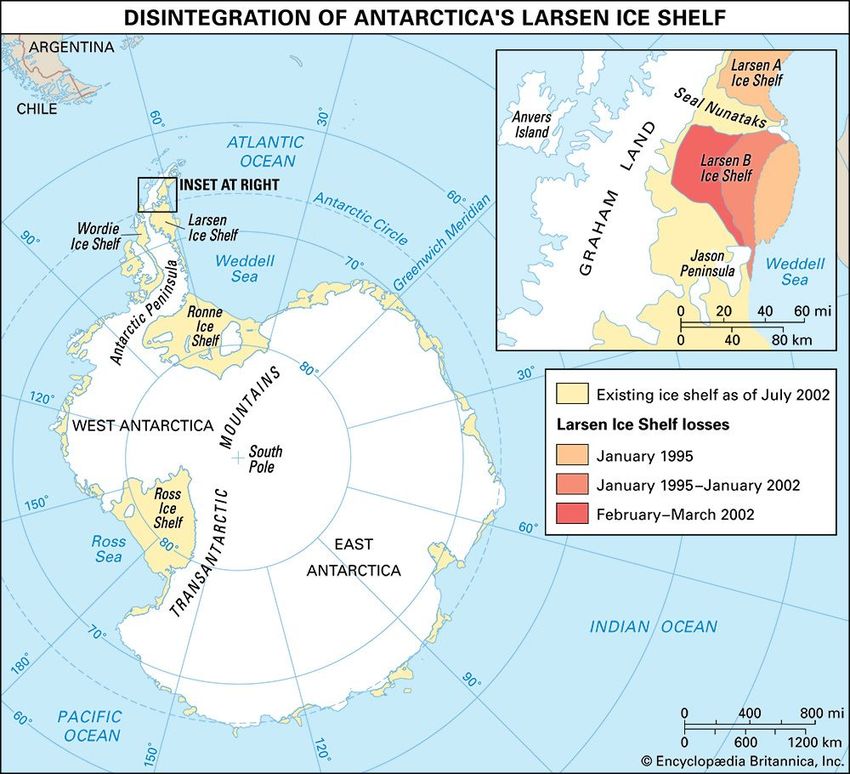
Britannica LaunchPacks | Landforms and Landscapes

 A map shows the extent of collapse of the Larsen Ice Shelf in Antarctica. The Larsen A Ice Shelf…

 Encyclopædia Britannica, Inc.

 Another crucial research subject with worldwide implications is global warming. The effects of this gradual rise in
 Earth’s surface temperatures are most visible at the poles. West Antarctica is one of the fastest-warming places
 on Earth. The collapse of much of the Larsen Ice Shelf, part of the Antarctic Peninsula, between 1995 and 2002
 was largely attributed to climate changes resulting from rising air temperatures. Continued melting of the
 glaciers and ice sheets of Antarctica could contribute to a dangerous rise in the global sea level. The impact of
 global warming was a main goal of the International Polar Year of 2007–08, an international research project
 focused on Antarctica and the Arctic.

 History of Exploration

 An engraving based on a sketch by Charles Wilkes shows his men on the Antarctic ice.

 From Narrative of the United States Exploring Expedition by Charles Wilkes, U.S.N., Vol. II, 1849

 The first expedition to come close to Antarctica took place from 1772 through 1775. The English navigator James
 Cook sailed around the continent and came within 100 miles (160 kilometers) of it. Land was seen about 1820,
 when separate British, American, and Russian expeditions all claimed first sightings. In 1821 the American sealer
 John Davis made the first recorded landing on Antarctica, at Hughes Bay, on the Antarctic Peninsula. In the
 Antarctic summer of 1839–40 a U.S. Navy expedition headed by Charles Wilkes mapped 1,500 miles (2,400
 kilometers) along the coast of East Antarctica. The next summer James Clark Ross of Great Britain sailed into the
 Ross Sea, traveling as far south as a ship can go. The first recorded landing on mainland Antarctica was on Cape
 Adare in 1895, and the first group to spend a winter there did so from March 1898 to March 1899.

© 2020 Encyclopædia Britannica, Inc.                                                                            15 of 90
Britannica LaunchPacks | Landforms and Landscapes

 Beginning in the early 20th century, several explorers set out to reach the South Pole. Roald…

 Encyclopædia Britannica, Inc.

 Encyclopædia Britannica, Inc.

© 2020 Encyclopædia Britannica, Inc.                                                              16 of 90
Britannica LaunchPacks | Landforms and Landscapes

 Roald Amundsen, 1923.

 UPI/Bettmann

 The struggle inland and toward the geographic South Pole began with the first expedition by Robert F. Scott of
 Great Britain in 1901–04. A fellow Englishman, Ernest Shackleton, led an expedition that came within 112 miles
 (97 nautical miles, or 180 kilometers) of the pole in 1909. But the first person to reach the pole was Roald
 Amundsen of Norway on December 14, 1911. On another Antarctic expedition Scott arrived at the pole just a
 month later; he died on March 29, 1912, trying to return to the coast.

 Richard E. Byrd.

 © N. G. Thwaites—Hulton Archive/Getty Images

 These early expeditions relied on sail power, dog power, and human power for their transportation. The
 mechanical age arrived on November 16, 1928, when George Hubert Wilkins, leading an American expedition,
 made an airplane flight from Deception Island. On November 29, 1929, Richard E. Byrd of the United States flew
 a three-motor Ford plane over the South Pole. Byrd also explored parts of Antarctica by air and on the surface in
 1933–35 and 1939–41 and commanded the largest single expedition to Antarctica yet attempted—the U.S. Navy’

© 2020 Encyclopædia Britannica, Inc.                                                                            17 of 90
Britannica LaunchPacks | Landforms and Landscapes

 s Operation High Jump in 1946–47. Thirteen ships, 25 airplanes, and thousands of men made surveys almost all
 the way around the continent.

 Vivian Ernest Fuchs, center, with fellow expedition team members W. Stanley Moss (immediately left…

 © The Estate of William Stanley Moss; reproduced by permission

 Shackleton made the first attempt at an overland crossing of Antarctica in 1914. His ship was caught and
 crushed, however, in ice in the Weddell Sea. The idea of an overland crossing lay dormant for several decades
 until it came to fruition during International Geophysical Year with the British Commonwealth Trans-Antarctic
 Expedition led by Vivian Ernest Fuchs. Using tracked vehicles and aided by aerial flights, the party left
 Shackleton Base on Filchner Ice Shelf on November 24, 1957, and by way of the South Pole reached the New
 Zealand Scott Base on Ross Island on March 2, 1958. In 1979–81 the continent was again crossed as part of the
 British Transglobe Expedition, which made the first polar circumnavigation of the world. In 1990 a six-man
 international expedition led by the American Will Steger completed a 221-day trek across Antarctica using
 dogsleds. At more than 3,700 miles (6,000 kilometers), it was the longest dogsled trek, as well as the first
 unmechanized passage through the South Pole. (See alsopolar exploration; world exploration at a glance.)

 Guy G. GuthridgeEd.

 Additional Reading
 DEWEY, JENNIFER.   Antarctic Journal: Four Months at the Bottom of the World (HarperCollins, 2001).GOGERLY, LIZ.
 Amundsen and Scott’s Race to the South Pole (Heinemann, 2007).HACKWELL, W.J. Desert of Ice (Scribner, 1991).
 KALMAN, BOBBIE, AND REBECCA SJONGER.      Explore Antarctica (Crabtree, 2007).MYERS, W.D. Antarctica: Journeys to the
 South Pole (Scholastic, 2004).PRINGLE, L.P. Antarctica: The Last Unspoiled Continent (Simon & Schuster, 1992).
 ROBERSON, DENNIS.   Antarctica (Lucent, 2003).WOODS, MICHAEL. Science on Ice: Research in the Antarctic (Millbrook,
 1995).

 Citation (MLA style):

 "Antarctica." Britannica LaunchPacks: Landforms and Landscapes, Encyclopædia Britannica, 23 Nov. 2021. packs.
 eb.com.au. Accessed 10 Apr. 2022.

 While every effort has been made to follow citation style rules, there may be some discrepancies. Please refer to
 the appropriate style manual or other sources if you have any questions.

© 2020 Encyclopædia Britannica, Inc.                                                                                18 of 90
Britannica LaunchPacks | Landforms and Landscapes

 coast
 The area where the sea and land meet is called a coast. The coasts of the world measure about 312,000
 kilometres (193,000 miles) in total. Coastal areas are also known as shores and seasides. They form unique
 habitats where a range of animals and plants survive in a challenging environment.

 There are many different types of coast. They may be sandy, rocky, muddy or covered in shingle. Some have
 steep cliffs that are buffeted by waves, while others are broad stretches of land that alternate between being
 wet and dry as the tides go in and out.

 How Coasts Are Formed
 Coasts have changed over millions of years. They are affected by geological events such as volcanic activity, ice
 ages and changes in sea levels. Two other factors that affect the shape and type of coast are erosion and
 deposition.

 Erosion
 Erosion is the wearing away of rocks or soil by the action of water, wind or ice. At the coastline, waves force
 pockets of air against rocks, which expand and explode, causing damage to the rocks over time. The continual
 force of waves against rocks and soil also wears them down, breaking them up into smaller and smaller
 fragments. Water that gets trapped in cracks and crevices can freeze in cold weather, causing more damage
 when it expands, forcing cracks to open wider. Plants, animals and humans can also cause coastal erosion.

 Sea arches, like this one in Dorset, England, are formed by wave erosion.

 Photos.com/Getty Images

© 2020 Encyclopædia Britannica, Inc.                                                                               19 of 90
Britannica LaunchPacks | Landforms and Landscapes

 Headlands and bays are features of coasts that are formed by erosion. Waves wear down different…

 Encyclopædia Britannica, Inc./Patrick O'Neill Riley

 Erosion at the coast can result in the formation of features such as sea caves, arches, bays and coves. One
 important effect of coastal erosion can be the loss of land and homes when cliffs fall into the sea.

 Deposition
 Deposition is the laying down of materials, such as rocks, stones, gravel, sand and mud. As rivers reach the
 shoreline they widen and lose much of their energy. When this happens, the load of materials they have been
 transporting is dropped to the bottom of the river bed or in the sea. Sandy beaches, estuaries, sand bars, spits,
 deltas and lagoons are the result of deposition.

 Animals and Plants
 The living organisms that inhabit coasts form part of a special ecosystem. These animals and plants have to
 cope with extreme weather conditions of wind and rain, salty water, tides and waves. For this reason many
 coastal organisms do not live anywhere else.

 Rocky shores are high-energy habitats where waves pummel the coast, making it difficult for animals to live
 there. However, when the tide goes out, rock pools provide sanctuaries for small crabs and soft-bodied animals
 such as sea anemones. Shelled animals, such as mussels and barnacles, attach themselves firmly to the rocks,
 and can withstand the biggest waves. Jellyfish and shells can sometimes be found washed up on the shore,
 particularly after a storm at sea.

 Seaweed such as brown kelp and bladderwrack are common at coasts and sea lettuce forms a bright green,
 slimy carpet on smooth rocks. Multicoloured lichens cover exposed rocks above the waves.

 On sandy beaches, lugworms live beneath the water: their holes and wormcasts are the only sign of their
 presence when the tide goes out. In drier zones, such as sand dunes and clifftops, spiky marram grass, sea
 lavender and pink thrift grow.

 Sea birds often roost in coastal areas and the nests of terns and plovers can be found on rocky shores. Herring
 gulls, black-headed gulls, redshanks and common terns are amongst the many types of bird that visit coasts in
 search of food. Large birds, such as the peregrine falcon, build their nests on cliff faces.

 Fossils
 The erosion of a coast can have unexpected benefits, revealing clues to the types of animals and plants that
 lived in the area millions of years ago. Fossils, or remains, of ammonites and other marine animals can be found
 on the Northumbrian and Dorset coasts of England, for example. The soft cliffs of East Anglia and the Isle of
 Wight have been eroded to reveal many ancient remains of animals that lived long ago, including dinosaurs,
 woolly mammoths and sharks.

 Coasts and People
 Over thousands of years, coasts have proved to be good places to live, and human ancestors are known to have
 set up home by the sea. The water is full of life, such as fish and shellfish, so it provided a plentiful source of
 food. Caves and cliffs offered shelter from the weather and from predators such as wolves.

 Coastal Settlements
© 2020 Encyclopædia Britannica, Inc.                                                                                   20 of 90
Britannica LaunchPacks | Landforms and Landscapes

 Coastal Settlements
 Many coastal areas began to develop and change about 15,000 years ago as the Ice Age was drawing to an end.
 The ice melted, sea levels rose and people were able to move north. They began to inhabit caves, often near the
 shore. The United Kingdom’s oldest-known dwelling has been discovered by archaeologists at a cliff edge at
 Howick, in Northumberland. The people who lived there, around 9,600 years ago, collected flints from the coast
 to make their tools.

 Travellers and Invaders
 Living by the sea enabled people to trade with travellers from overseas. Coastal communities have since
 maintained strong links with other countries. They often have diverse cultures and foods, which reflect the wide
 variety of peoples that have visited their shores.

 The Normans built Bamburgh Castle on the coast of Northumberland, England, so they could defend…

 Photos.com/Jupiterimages

 Unwelcome visitors, such as invaders, may also make their first appearance at coastal areas. For this reason,
 Britain’s coasts are peppered with castles and other military buildings which, through history, have provided a
 first line of defence against invasion. Dover Castle in south-east England was built on land that has been
 occupied as a defensive site since the Iron Age, at least 2,400 years ago. Bamburgh Castle in Northumberland
 was built by the Normans following their invasion in 1066. Pendennis Castle in Cornwall was built by Henry VIII to
 defend England against invasion by the Spanish and French.

 Changing Coastlines

 Structures called groins, or groynes, protect coastlines from the power of the waves.

 © Paul Cowan/Dreamstime.com

© 2020 Encyclopædia Britannica, Inc.                                                                           21 of 90
Britannica LaunchPacks | Landforms and Landscapes

 Coasts are continually changing. Deposition and erosion form and reform the land. Other changes are the result
 of the movement of plates that make up Earth’s crusts (seeplate tectonics). In the long term, sea levels rise and
 fall because of this movement. Scientists have also predicted that changes in climate caused by global warming
 will cause sea levels to rise. An increase in marine pollution is also affecting coasts and their delicate
 ecosystems.

 Grasses help keep sand dunes in place.

 © ehrlif/stock.adobe.com

 In some places these changes can cause damage to buildings and can cause beaches to disappear. However,
 engineers have developed several different ways to protect coasts. Engineers can build structures to keep the
 waves from hitting the shore. They can also use the natural surroundings to help protect the coasts. They may
 replace sand that has been washed away, or they may restore sand dunes by planting grasses. The grasses help
 keep wind and water from blowing or washing the sand away.

 Citation (MLA style):

 "Coast." Britannica LaunchPacks: Landforms and Landscapes, Encyclopædia Britannica, 4 Mar. 2022. packs.eb.
 com.au. Accessed 10 Apr. 2022.

 While every effort has been made to follow citation style rules, there may be some discrepancies. Please refer to
 the appropriate style manual or other sources if you have any questions.

 desert
 Any barren region that supports very little life may be called a desert. More commonly, however, the term desert
 is reserved for regions that are barren because they are arid, or dry. Arid deserts receive little precipitation and
 are characterized by specialized plants that tolerate drought conditions and salty soils. Occupying some 20
 percent of the Earth’s surface, deserts are one of the planet’s main types of ecosystems. They may or may not
 be hot, and their land features range from windswept expanses of loose sand to rugged mountains, bare rock,
 and plateaus strewn with gravel and boulders.

© 2020 Encyclopædia Britannica, Inc.                                                                              22 of 90
Britannica LaunchPacks | Landforms and Landscapes

 Joshua trees and other yucca plants grow in the desert in Joshua Tree National Park in California.

 © Max Baumann/Shutterstock.com

 Climate and World Distribution

 Atacama Desert, Chile.

 Encyclopædia Britannica, Inc.

 Deserts are areas in which there is a shortage of moisture available for plants. There is no precise measure of
 how dry such an area must be to be called a desert. Characteristically, deserts receive an average of less than
 10 inches (25 centimeters) of rain or other precipitation per year. Many deserts get less than half that amount of
 rain yearly, and some receive almost none. Regions with an average annual precipitation between some 10 and
 16 inches (25 and 40 centimeters) are often called semideserts.

 But rainfall is not the only factor that influences how much water is available to support plants. The distribution
 of the rainfall throughout the year, the humidity of the air, and the temperature and amount of sunshine all play
 a role. Some definitions of deserts focus on the imbalance between the amount of precipitation received and the
 amount of moisture that could be lost through evaporation and through plants’ leaves. In the Sonoran Desert, in
 the southwestern United States and Mexico, for example, a year’s potential evaporation—the amount of
 evaporation that would occur if water were always present—is some 100 inches (250 centimeters). This is about
 20 times the actual annual rainfall.

 Rainfall in deserts is not only scanty but also erratic. Most deserts have at least a few days of rain a year, but
 some may get no rain at all for several years or receive a year’s amount in one storm. For example, Iquique, in
 northern Chile, had no rain for a period of four years. The fifth year brought 0.6 inches (1.5 centimeters), making
 a five-year average of 0.12 inches (0.3 centimeter). At another time 2.5 inches (6.4 centimeters) fell in a single
 shower.

© 2020 Encyclopædia Britannica, Inc.                                                                              23 of 90
Britannica LaunchPacks | Landforms and Landscapes

 Most of the world's hot deserts lie between 20° and 35° north and south of the equator. The main…

 Encyclopædia Britannica, Inc.

 There are two main types of arid desert: hot and temperate. Most of the Earth’s deserts are found between 20°
 and 35° in both north and south latitudes, near the Tropic of Cancer and the Tropic of Capricorn, respectively.
 Except for a couple of coastal deserts kept cool by ocean currents, these deserts are hot. They occupy
 subtropical regions that straddle a wet, tropical region around the equator. Because of the predominant air-
 circulation patterns, the air that descends into the subtropical regions has already rained out most of its
 moisture over the tropical lands. The air is also heated as it descends, which further prevents rain.

 Temperate deserts are found farther from the equator, in the middle latitudes. They occur mainly in Central Asia,
 with smaller areas in western North America, southeastern South America, and southern Australia. These deserts
 are generally separated from the coast by mountains or by great distance. Air picks up moisture from the ocean,
 but by the time it reaches these regions, it has lost much of its moisture over either the mountains or the land
 nearer the coast.

 Ice cap and tundra regions around the poles are sometimes called cold deserts. They have little precipitation,
 but the dearth of vegetation is caused chiefly by the cold.

 Temperatures range widely in deserts. In hot deserts, daytime air temperatures above 100° F (38° C) occur
 regularly in summer. Al Aziziyah, Libya, holds the record for the hottest temperature with a high of 136° F
 (57.8° C), while Death Valley, Calif., comes close with 134° F (56.7° C). Winters are cold in temperate deserts,
 located far from the equator. The Gobi, in Central Asia, for example, has an average low temperature of −40° F
 (−40° C) in January and an average high of 113° F (45° C) in July.

 The temperature drops sharply in the desert night. Dry air, cloudless skies, and bare, dry earth furnish ideal
 conditions for the cooling of air after sunset. A 24-hour range of 25 to 45 Fahrenheit degrees (14 to 25 Celsius
 degrees) is common, and it may exceed 60 to 70 Fahrenheit degrees (33 to 39 Celsius degrees).

© 2020 Encyclopædia Britannica, Inc.                                                                              24 of 90
Britannica LaunchPacks | Landforms and Landscapes

 Land Forms

 People get water at a well in the Thar (Great Indian) Desert, in western Rajasthan, India.

 © virdg/Fotolia

 Sagebrush blooms in the Chisos Mountains, in Big Bend National Park, in southwestern Texas. The park …

 © jamespharaon—iStock/Getty Images

 Desert areas differ greatly in their surface features, which range from mountains to plateaus to plains. The
 ground may be bare rock or be covered with sand, scattered boulders, or a “desert pavement” of coarse gravel
 and stones. Although sand dunes are spectacular features of deserts, they are not as common as generally
 believed. In the deserts of the southwestern United States, for example, dunes occupy less than 1 percent of the
 surface. In the most sandy of all deserts, the Arabian, dunes occupy only about 30 percent of the total area. If
 sand accumulations on plains are extensive and appear as a “sand sea,” they are called ergs.

 A more common type of desert consists of rugged mountains separated by basins called bolsons. The mountains
 receive most of the rains in downpours. As the water rushes down the steep slopes it cuts deep gullies and
 carries rock fragments, gravel, and sand to the bolson. These materials are freed from the water when it slows
 or evaporates, and they are deposited as cones or in fans of sediment called alluvial fans. The rugged forms
 produced in this way, such as the terrain in Death Valley, are termed badlands.

 Sometimes floodwaters make a temporary shallow lake in the basin. The temporary lakes that form in basins
 with no outlet are called playa lakes. Typically the water soon evaporates into the air or filtrates into the ground,
 leaving behind sediments of clay, silt, and sometimes salt. The flat-bottomed depression that is formed by the
 water is called a playa. In narrow basins, alluvial fans and badlands may extend to the edge of the playa. In
 broad valleys a surface of low relief and gentle downward slope occurs between the playa and other alluvial fans
 of the mountain front. Such a surface is called a desert flat or llano.

© 2020 Encyclopædia Britannica, Inc.                                                                              25 of 90
Britannica LaunchPacks | Landforms and Landscapes

 Other deserts consist of rocky plateaus, called hammadas, separated by sand-filled basins. Here differences in
 altitude are usually slight. Many hammadas are broad, almost flat, dome-shaped areas. Where streams or wind
 wear away the weaker rocks, strong rock formations stand out boldly as mesas or cuestas. Pinnacles, needles,
 and arches carved in colored rocks lend fantastic beauty to the deserts of the American Southwest. Gullies are
 cut deep into the hammadas by the wearing force of the torrents. Gullies are known as wadis in Arabia and
 arroyos in the Southwest.

 Plants and Animals

 Plants in the deserts of Arizona have varying strategies to survive the dry conditions.

 Encyclopædia Britannica, Inc.

 Few parts of the desert are entirely barren. Where water seeps toward the surface, a great variety of plants
 spring up. After a rain low shrubs and grasses come to life. At blooming time, the plants are fragrant and bright
 with color. They grow quite far apart, instead of providing complete ground cover. Trees and large shrubs can be
 found in the desert, but they are not prominent in the driest regions.

 Learn about the saguaro cactus, a plant unique to the Sonoran Desert, as found in Saguaro National…

 Encyclopædia Britannica, Inc.

 Desert plants differ in the ways they are adapted to arid places. Some plants sprout when the rain falls, bloom
 quickly, ripen their seed in a few days, then wither and die. Other plants survive periods of water shortage by
 drying up and becoming physiologically inactive. When more water becomes available they swell up and resume
 activity. Some desert plants depend upon underground water and have long root systems, while others are able
 to absorb dew. Various adaptations of the leaves, such as smaller surface areas, help prevent the loss of
 moisture. In most species of cactus, for example, leaves are either absent or very small. Cacti and other

© 2020 Encyclopædia Britannica, Inc.                                                                            26 of 90
Britannica LaunchPacks | Landforms and Landscapes

 succulent plants also store water in their thick, fleshy tissues to help them survive long dry periods. (See also
 sagebrush.)

 Animals live in all but the most barren stretches. The camel is the most useful domestic desert animal. Its
 physical structure permits it to travel far without water. Various wild mammals, birds, and reptiles of arid regions
 must get all their moisture from their food. In times of drought, many desert animals remain inactive for long
 periods. Others hide from the sun during the hottest daytime hours and come out at night to feed. More than
 half of desert animals live at least part of the time underground, where it is cooler and more humid. Another
 strategy is migration: many birds and other desert animals survive by regularly moving to areas that have
 recently received rain.

 People and Deserts
 Deserts are much less densely populated than other land areas. People can live and grow crops in the desert
 only at places where they can get water, called oases. In some spots ordinary shallow wells reach the water
 table, or the upper boundary of underground water, but usually groundwater lies at greater depths in deserts
 than in humid lands. In alluvial fans the water sinks deep into the porous material, but it may be reached by a
 well at the tip of the fan.

 In wadis, ordinary wells can usually tap a supply of good water. Oasis settlements therefore are most often
 found where wadis are numerous. Ergs into which many wadis drain may have a water supply. Desert shrubs in
 the hollows between the dunes signal its presence. Deep artesian wells may be bored where the rock structure
 holds water under pressure. In some oases an artesian spring flows through a crack in the rock.

 Streams that rise in rainy regions outside deserts bring the most generous supply of water for irrigation. All the
 large deserts except those of Australia are crossed by these so-called exotic rivers. The largest and best known
 of them are the Nile in Egypt, the Tigris and Euphrates in Iraq, the Indus in Pakistan, and the Colorado in the
 United States.

 Desert soils are usually productive when given water. They are coarse textured and highly mineralized. Most
 widely cultivated are the water-transported soils of floodplains and alluvial fans. Land is precious in oases, so it
 is intensively cultivated. In North African and Asian oases, the chief food crops are dates, figs, wheat, barley,
 rice, and beans. Oasis farmers also raise such crops as cotton and sugarcane. In the United States irrigated lands
 are mainly used for citrus fruits, dates, winter vegetables, and cotton.

 The proper development of critical water resources has focused on improving surface-water management
 techniques, improving control and storage of surface runoff, reducing loss from shallow aquifers, and desalting
 brackish waters. The buildup of salts in the soil has become a serious problem that is being studied in several
 nations. The introduction of cultivated plant species with greater salt tolerance, as has been done in Israel,
 seems to be a promising alternative to abandoning arid land.

 Humans have changed many desert environments. Irrigated lands have been extended by giant river-control
 systems. Oases once reached only by camel now have airports and gas stations for motor vehicles. Settlements
 have sprung up in deserts to obtain such valuable minerals as the petroleum of Saudi Arabia, Iraq, and Iran and
 the copper and other metals of arid North and South America. Typical desert minerals are soluble salts left
 behind by evaporation. Sodium nitrate, the most valuable, comes from the north Chile desert.

 The mismanagement or overuse of arid and semiarid lands can cause desertification, or the spread of desert
 environments. Excessive cultivation of the land, clearing away the vegetation, or exhausting the water supply

© 2020 Encyclopædia Britannica, Inc.                                                                                 27 of 90
Britannica LaunchPacks | Landforms and Landscapes

 can rob arid or semiarid land of its ability to sustain life. Factors such as long-term climate change or severe
 drought can also cause desertification.

 Charles William Finkl, Jr.Ed.

 Citation (MLA style):

 "Desert." Britannica LaunchPacks: Landforms and Landscapes, Encyclopædia Britannica, 4 Mar. 2022. packs.eb.
 com.au. Accessed 10 Apr. 2022.

 While every effort has been made to follow citation style rules, there may be some discrepancies. Please refer to
 the appropriate style manual or other sources if you have any questions.

 Echo Caves
 The Echo Caves are among the oldest caves in the world. These limestone caves are in the Molapong Valley in
 the South African province of Limpopo, about 6 miles (10 kilometers) west of Motlatse Canyon. The name derives
 from the echoes that are heard when rock formations within the caves are struck. The echoes can be heard
 outside the caves.

 The cave system is about 25 miles (40 kilometers) long, but its full extent is unknown. One of the largest rooms
 in the system is about 328 feet (100 meters) long and 190 feet (60 meters) high. The Madonna and Crystal
 Palace chambers are some of the latest discoveries. Visitors can go on guided tours.

 The caves have many impressive rock formations, including stalagmites and stalactites. A stalagmite is cone-
 shaped and rises up from the cave floor. A stalactite is a cone that hangs from the ceiling.

 People lived in the caves in prehistoric times. Cave dwellers may have used the rock formations as drums to
 warn each other when danger was near. Tools and other evidence of these early people are exhibited in a
 museum near the caves. There is also rock art in the caves that was made by the San people hundreds of years
 ago.

 The caves were unknown to European settlers in the region until 1923, when the owner of a farm called
 Klipfonteinhoek found them. When his cattle disappeared, the farmer wanted to find out what had happened to
 them. He discovered that the cattle had been going into the Echo Caves.

 The caves were not open to the public until 1960, after the completion of the Abel Erasmus Pass and the J.G.
 Strijdom Tunnel through the Drakensberg range. The caves were later declared a South African national
 monument.

 Citation (MLA style):

 "Echo Caves." Britannica LaunchPacks: Landforms and Landscapes, Encyclopædia Britannica, 17 Sep. 2018.
 packs.eb.com.au. Accessed 10 Apr. 2022.

© 2020 Encyclopædia Britannica, Inc.                                                                                28 of 90
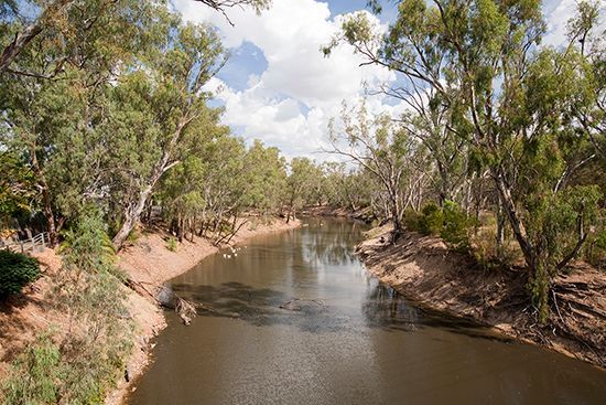
Britannica LaunchPacks | Landforms and Landscapes

 While every effort has been made to follow citation style rules, there may be some discrepancies. Please refer to
 the appropriate style manual or other sources if you have any questions.

 Great Victoria Desert
 An immense dry area known as the Great Victoria Desert stretches across southern Australia. It lies in the states
 of Western Australia and South Australia, between the Gibson Desert on the north and the Nullarbor Plain on the
 south. The Great Victoria Desert extends eastward from Kalgoorlie almost to the Stuart Range. It covers an area
 of about 250,000 square miles (647,000 square kilometers). Most of the desert consists of a vast expanse of
 sand dunes, though in some places a layer of tightly packed pebbles covers the ground.

 Great Victoria Desert, Australia.

 Encyclopædia Britannica, Inc.

 Spinifex grass grows in the Great Victoria Desert of southern Australia.

 © N Mrtgh/Shutterstock.com

 The Great Victoria Desert receives only about 6 to 10 inches (15 to 25 centimeters) of rain each year. The desert
 has very hot summers and cooler winters, when nighttime temperatures may drop below freezing.

© 2020 Encyclopædia Britannica, Inc.                                                                           29 of 90
Britannica LaunchPacks | Landforms and Landscapes

 Grass of the genus Triodia (Spinifex) grows in parts of the desert, and there are also scattered acacia trees and
 shrubs. Wildlife includes reptiles such as skinks, geckos, monitor lizards, and copperhead snakes as well as mice,
 dingoes, and foxes.

 The Great Victoria Desert was named by the Australian explorer Ernest Giles, who led a party across it from east
 to west in 1875. Few people live in the desert. Some Australian Aboriginal people live in the eastern regions. The
 Australian government uses parts of the Great Victoria Desert to test weapons. There are several national parks
 and nature reserves in the area, including the Great Victoria Desert Nature Reserve and Nullarbor National Park.

 Citation (MLA style):

 "Great Victoria Desert." Britannica LaunchPacks: Landforms and Landscapes, Encyclopædia Britannica, 4 Mar.
 2022. packs.eb.com.au. Accessed 10 Apr. 2022.

 While every effort has been made to follow citation style rules, there may be some discrepancies. Please refer to
 the appropriate style manual or other sources if you have any questions.

 Huang He (Yellow River)
 The main river of northern China, the Huang He (or Hwang Ho) is the second longest river in the country, after
 the Yangtze. It rises on the Plateau of Tibet and flows generally eastward, emptying into the Yellow Sea. Chinese
 historians routinely refer to the Huang He as the cradle of Chinese civilization. The river, its tributaries, and its
 valley have played an integral part in the history of China for more than 3,000 years. Along the middle and lower
 reaches of the system, Chinese civilization and agriculture first developed, and the earliest capitals of the
 dynastic era, Anyang and Luoyang, were located there. Control of the river and its drainage area provided the
 great surplus of grain required for China’s military and political expansion beginning in the Qin Dynasty (221–
 207 BC).

 The Huang He (Yellow River) is the main river of northern China. It flows eastward from the Plateau…

 Encyclopædia Britannica, Inc.

© 2020 Encyclopædia Britannica, Inc.                                                                                30 of 90
You can also read