LARIMER COUNTY OFFICE OF EMERGENCY MANAGEMENT - WWW.LARIMER.ORG/EMERGENCY - emergency preparedness guide
←
→
Page content transcription
If your browser does not render page correctly, please read the page content below
LARIMER COUNTY

LARIMER COUNTY OFFICE OF EMERGENCY MANAGEMENT
            WWW.LARIMER.ORG/EMERGENCY
TO OUR
COMMUNITY
A Letter from the County Commissioners
WE CAN BE A MORE PREPARED LARIMER
     COUNTY STARTING WITH YOU!
We know that many of us have experienced a great deal of hardship in recent years,
particularly following the events of 2020 and 2021 when we suffered significant disasters
impacting Colorado, including our county and beyond. Nevertheless, Larimer County is
home to incredibly resilient community members, which has been demonstrated time and
time again.

Larimer has been, and will continue to be, impacted by a wide range of hazards, both natural
and human-related, that could result in various emergencies and disasters. The Larimer
County Board of County Commissioners understands the challenge, and the responsibility,
to be prepared for, respond to, and recover from these types of events. Being ready for
disasters and ensuring the future of our resilience county-wide takes intentional partnership
between the county and our community members. Key components of this partnership
are ensuring our community is aware of the risks that exist in our local area and providing
recommendations and resources on how to be better prepared. Development and release
of this preparedness guide is one of the many ways in which Larimer County works with our
community to be better prepared and more resilient to hazards we may face.

Disaster preparedness is a partnership, and we call upon our local community to share in this
responsibility. Having a well-thought out personal and family preparedness plan is the first
crucial step in ensuring the safety and wellbeing of yourself, your family, and furthermore,
your community. We encourage you to utilize this guide as a tool in building awareness
of the natural and human caused disasters that exist in Larimer County, and to use this as
guidance for development of your own preparedness plan.

This preparedness guide has been updated with the current resources and lessons learned
we have here locally. It has been developed by the Larimer County Office of Emergency
Management in collaboration with the Larimer County Sheriff’s Office as well as other critical
local emergency management agencies and partners. It is our hope that this information will
not only help minimize the fear and anxiety associated with disasters, but that it will inspire
and empower you to feel more ready for the future. We hope the guide will enhance your
ability to make the decisions that are best for you and your family before, during, and after a
disaster.

Larimer County is a special place, and we are fortunate you are part of the community in
which we live, work, and play. Thank you for taking action to make us more resilient.

       John Kefalas                   Kristin Stephens            Jody Shadduck-McNally
    Commissioner, District 1        Commissioner, District 2         Commissioner, District 3
                                                                                                  3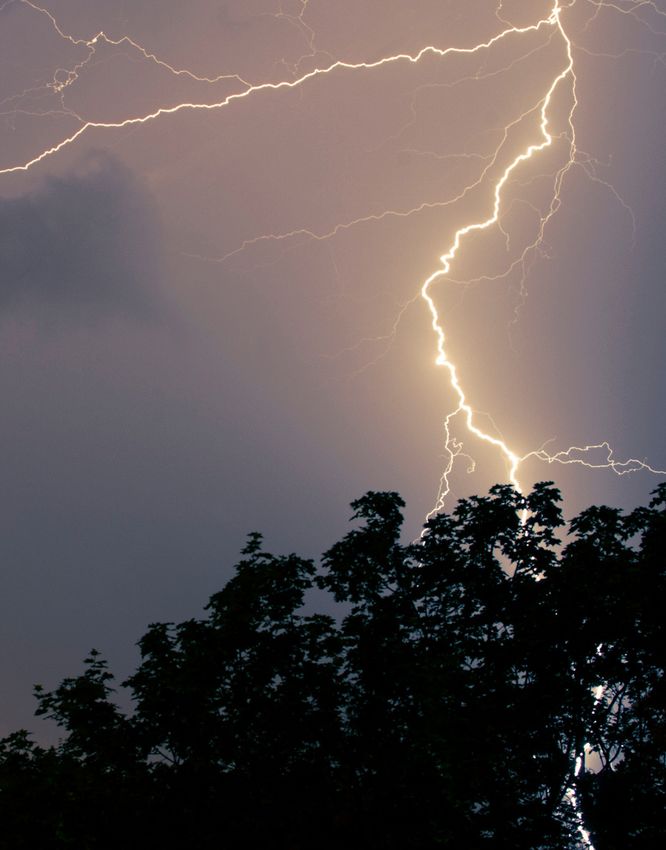
NOTE FROM THE SHERIFF
                      & OEM
                                   Larimer County is a unique and amazing place
                                   to live, work and play. The beauty and majesty
                                   of our mountains, rivers and plains is endless.
                                   However, the same features that make this such
                                   a great place to be also present potential dangers
                                   to those living and visiting our county. The events
                                   of 2012, 2013, and 2020 reminded us of the
                                   ever-present dangers from events like wildfires
                                   and floods. Despite these threats, the citizens of
                                   Larimer County have proven themselves amazingly
                                   resilient. This emergency preparedness guide
                                   has been developed as a tool to help residents to
                                   prevent, protect against, mitigate, respond to, and
                                   recover from the threats and hazards that exist in
                                   our community.
                                          - Larimer County Sheriff Justin Smith

    When we are prepared,
    we become an asset to
    our neighbors. It is always
    possible that you could
    be the first responder in
    any given situation, and by
    having the plans and tools
    needed to be ready at your
    disposal puts you ahead of
    the game to be able to better
    support those around you                                                       in
    need.
    Community preparedness is a team effort, and we are all in this together. We
    hope you utilize this resource as a guide to educate yourself and your family,
    make a plan that works best for you, and then share what you have learned with
    your neighbors. Community resilience starts with you, and together, we can
    ensure a strong Larimer County long into the future.
    				- Larimer County Office of Emergency Management

4
CONTENTS
  BREAKING DOWN EMERGENCIES 					6-11
		Emergency Situations
		    All About 911 & Medical Emergencies
		    Preparing for Disruptions

  BE READY									                                 12-17
		     Education & Awareness
		Emergency Alerts
		     Watches vs. Warnings
		     All About Evacuations

  NATURAL HAZARDS							                            18-43
		Larimer County Primary Natural Hazards
		    Thunderstorms & Thunderstorm Hazards
		Wildfire
		Flash Floods
		    Winter Storms & Extreme Cold

  HUMAN-RELATED HAZARDS					                        44-53
		   Larimer County Primary Human Caused Hazards
		Home Fires
		Criminal Activity
		Terrorism
		HAZMAT
		   Larimer County Planning Committee

  PREPARE									                                  57-71
		    Emergency Preparedness for the Whole Family
		    Pets & Livestock
		Community Resilience
		    VOAD & Volunteer Response
		    Preparing a Disaster Supply Kit
		    Family Emergency Contact Sheet

                                                            5
BREAKING DOWN
     EMERGENCIES

66
EMERGENCY SITUATIONS
 are complex! There are a lot of different entities that are involved in keeping
 our community safe. There is also a lot of work that is done before and after
emergency situations to help our community prepare and recover from disaster!

Who is involved                             6. Volunteers - play a crucial role in
in an emergency?                            emergencies. The volunteer fire fighters
                                            and EMTs are often the first to give
1. Communications                           aid at in incident. Search and rescue
Centers - are involved                      volunteers can spend days looking
in such things as answering 911             for someone. Dive and ice rescue
calls, notifying appropriate response       volunteers pull people from dangerous
authorities of a situation, coordinating    water and ice. Other volunteers help
support, and issuing evacuations.           with clean up from fires and floods.

2. Sheriff’s Office - are in charge of      7. Road & Bridge / Utilities - Often
Law Enforcement for Larimer County.         these groups go overlooked, but they
Additionally, the Sheriff’s Office is the   are important first responders! Road
lead for evacuation operations, and         and Bridge personnel ensure that roads
serves as the Marshall for wildland         are plowed for emergency vehicles or
fire in the county.                         help repair damaged roads after a flood.
                                            Additionally, Utilities personnel work
3. Fire Protection - In Larimer             hard during severe weather to make
County, there are Fire Authorities,         sure that power can get to our homes
Fire Protection Districts, and Fire         and buildings, which can prevent further
Departments. They respond to                emergencies!
structure and wildland fires, and
other emergency situations in our           8. Office of Emergency Management
communities. They are responsible           - OEM is involved in all phases of
for emergencies in their jurisdictions      a disaster including preparedness,
and provide mutual aid to neighboring       prevention, mitigation, response, and
jurisdictions when needed.                  recovery. OEM serves 3 key roles
                                            - assisting with public information,
4. Emergency Medical Service - are          supporting responders in the field, and
involved in the care and transport of       community support (such as activating
patients needing medical care.              overnight shelters with community
                                            partners).
5.Police Departments - are in charge
of law enforcement within municipal         9. You! You serve a key role in an
jurisdictions.                              emergency. Being prepared is the first
                                            step. Read on to learn more!

                                                                                       7
ALL ABOUT 911 & MEDICAL
EMERGENCIES
WHEN YOU DIAL 911
in Larimer County, your call, whether by landline or cell
phone, will be received by any one of 5 communications
centers. The Emergency Telecommunicators at these centers
will help you by determining the nature of your emergency
and what type of response will be needed based on your
location and circumstances.
CALL BOXES
Callboxes can be found throughout Larimer County. They are often located in
places where phone service is sparse. By picking up the receiver or pressing
the call button on the callbox, citizens can reach an emergency communications
center for emergency assistance.
TEXT TO 911
All emergency communications centers in Larimer County are currently equipped
to receive and handle Text-to-9-1-1 calls. Text-to-9-1-1 is very useful to those
who are hard of hearing, deaf, or speech-impaired. Text-to-9-1-1 could also
help in situations when a caller is facing a threatening situation and a voice call
could increase the threat; the caller is injured and cannot speak; the caller is in a
remote location and can only send out a text message; or other scenarios. Please
remember that texting should only be used if you are unable to make a voice call
to 9-1-1.
911 IS... 911 IS NOT...
→ The number to call to report a → The number to call for phone
crime in progress numbers
→ The number to call if an emergency → The number to call for animal
threatening life or property exists problems
→ The number to call if you need → The number to call for directions
medical help → The number to call for road
→ The number to call if you see an conditions
accident → The number to call for power
→ The number to call if you see outages
smoke or flames
8
EMERGENCY ALERTS:
                      Register for emergency alerts at www.nocoalert.org

                      Information about Larimer Emergency Telephone
                      Authority & 911 in Larimer County: www.leta911.org

                      Please go online to register your cell or VOIP phone for
                      emergency alerts and to learn more about the text to 911
                      feature.

           Call if you can, text if you must!
MEDICAL EMERGENCIES
In addition to sending emergency responders,
the Emergency Telecommunicator may give you
medical instructions or direct you in specific
actions to assist you with your emergency until
help arrives. Remember that when an ambulance
arrives to assess the situation, it’s free - but if you
are transported, fees may be involved for you or
your insurance company. A 9-1-1 call for assistance
in areas far removed from a hospital may require
an air ambulance to provide transportation to a
medical facility as soon as possible. With medical
emergencies, fires, law enforcement calls or
whatever the situation, 9-1-1 Emergency.

In addition to sending emergency responders, the Emergency Telecommunicator
may give you medical instructions or direct you in specific actions to assist you
with your emergency until help arrives. Remember that when an ambulance
arrives to assess the situation, it’s free - but if you are transported, fees may
be involved for you or your insurance company. A 9-1-1 call for assistance in
areas far removed from a hospital may require an air ambulance to provide
transportation to a medical facility as soon as possible. With medical emergencies,
fires, law enforcement calls or whatever the situation, 9-1-1 Emergency.

                                                                                      9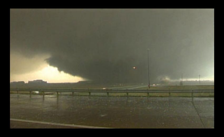
PREPARING FOR DISRUPTIONS
     Being prepared does not have to be overwhelming, nor does it have to be scary!

     We are going to let you in on a little secret (originally given to us by Aaron
     Titus, a member of our Local VOAD and author of the book, How to Prepare
     for Everything). The best way to prepare for disasters, is to not prepare for
     disasters at all!

     Think about it, the disaster itself is not what impacts us, but the disruptions the
     disaster causes. This could be things like displacement from your home, loss of
     power, or supply chain disruptions. So, if we plan for these disruptions, we can
     be better prepared in the event of a disaster to deal with them.

     While this guide will have hazard-specific information, we encourage you to
     think through this disruption’s lens. After all, it is easier to prepare a food supply,
     or think through what you might need for your pet if you have to be away from
     home for a while, versus simply “prepare for a flood.” In conclusion, preparing
     this way helps you be better prepared for a multitude of possible situations!

     A NOTE ON PERSONAL RESPONSIBILITY
     Every member of the community has personal responsibility for their own
     safety. This includes adequate planning and preparedness for the hazards and
     risks within each specific community. Larimer OEM is responsible for providing
     services and resources, as available, to all members of our community, but can
     only be successful with the help of every prepared individual. Self-reliance is a
     primary component in training and education programs in Larimer County to give
     community members the tools to help themselves and others in the event of a
     disaster. Community preparedness is a joint effort between emergency response
     agencies and community members.

          When you are prepared, you become an asset to your
          community and can better help support those in need!

10
WANT TO SHARPEN YOUR SKILLS?
In Larimer County, there are a lot of opportunities to learn emergency
preparedness skills for you and your family. A great way to build skillsets and
also be able to contribute to your community during a time of need is to get
involved with a volunteer organization. There is more information about this
on pages 64 and 65.
See below for examples the different types of training that may be offered
by Larimer County or community partners.
Want to learn more about training opportunities? Visit
https://www.larimer.gov/workshops-and-trainings-we-offer
HAM Radio CPR & Stop Community Resilience
& Emergency the Bleed & Neighborhood
Communications Support
Disaster Youth Disaster Financial
Preparedness Preparedness Preparedness
11BE READY
Understanding Alerts, Warnings
and Evacuations
12EDUCATION & AWARENESS
are the two keys to protecting yourself and your family in an extreme weather
event. There have been countless instances in the history of search and rescue
in Larimer County where victims placed themselves in harm’s way by refusing
to pay attention to a weather forecast or their surroundings. Remember,
4-wheel drive vehicles are not indestructible and may offer a false sense
of security. They can and do get stuck in snow and are easily swept away
in floods as any other vehicle! Pay attention to weather advisories, watches,
and warnings. Educate yourself on the differences between them, know the
best way to respond, and share this knowledge with your family and friends.
Practice situational awareness by learning to be aware of your surroundings
and seek further information if you sense imminent danger. Keep tune to the
latest hazardous weather information and weather forecasts, and always have
an emergency plan set in place within your family.
EMERGENCY ALERTS
NOCO ALERTS
Emergency alerts are sent when there
is an imminent threat to life in situations
such as such as wildfires, floods, gas
leaks, dangerous weather, or critical
law enforcement activity. If you have a
traditional landline phone, your landline will
automatically receive emergency alerts. The
emergency notification system also allows
residents of Larimer County to sign up for
FREE emergency alerts on their cell phone,
work phone, VOIP phone, home phone, text
message, and email.
If you receive an emergency alert, please do not call 9-1-1 for clarification
or to ask questions unless you have an actual emergency. The NOCO Alert
website is a dedicated place for all information about emergency alerts in
Larimer County. Not only can residents sign up for alerts here, but they can
also view a map of the alert area, see current and previous alerts sent, and
discover non-emergency alert options for their community.
13HOW EMERGENCY ALERTS WORK
The Emergency Alert System in Larimer County allows us to
alert you if there is an emergency situation in your area creating
an imminent threat to life. You opt-in to enter your contact
information based on addresses you care about in Larimer
County. The information you provide is protected and will not
be used for any other purpose.
When we issue a notification about an imminent threat to life,
you will receive a message on the voice or text communication
methods that you have registered. If requested for the
notification, you can confirm that you have received the
message and you will not be contacted by any subsequent
methods regarding that particular notification. If you do not
confirm, the system will continue to attempt to reach you at all
of the contact paths that you have registered.
REACHWELL
RECEIVE ALERTS IN THE LANGUAGE OF YOUR
CHOICE!
An additional alerting tool has been added to Larimer Emergency Telephone
Authority’s emergency alert system! Starting April 1, 2022, all emergency alerts
in Larimer County will be delivered to the ReachWell app. Community members
simply set their language preference in the app and ReachWell will deliver
push notifications in the language selected. Choose from one of 103 different
languages, including Spanish, Arabic, Swahili, and more! This app serves as
an additional method to reach more people in Larimer County. We strongly
encourage all community members to also register for an emergency alert profile
at www.nocoalert.org.
Download the ReachWell app from the Apple App Store or Google Play today!
14WATCHES VS. WARNING -
WHAT IS THE DIFFERENCE?
A Weather Watch is issued when the conditions are
favorable for the development of severe weather
over the next several hours. If there is a weather
watch issued for your area, stay tuned to your local
media for the latest weather information and closely
monitor the situation. Review your emergency plan
with your family and have your emergency kit close
by. Be alert for changing weather conditions and
possible warnings. Weather watches are large areas
(typically 20,000 to 40,000 square miles) and are
issued by county. If a weather watch is issued close
to your location, but does not include your county,
you should still remain alert to the situation as
weather conditions can change suddenly.
WITH A WEATHER WATCH, ALL THE INGREDIENTS
ARE THERE FOR SEVERE WEATHER TO OCCUR
A Weather Warning is issued when a
dangerous weather event is imminent or
currently in progress. A weather warning
requires immediate action and may be life
threatening. You and your family should take
the appropriate actions necessary to seek
shelter and safety. Weather warnings are
usually issued as irregular shapes that may
cover only part of the county. Warnings are
also communicated in a variety of ways, and
some may include local cities and landmarks.
Therefore, know where you are relative to
your home county, local cities, and notable
landmarks, as well as neighboring counties to
better understand the threats relative to you
and your family.
WITH A WEATHER WARNING, THE CUPCAKE HAS
BEEN MADE AND IS HERE.
15ALL ABOUT EVACUATIONS
Larimer County is prone to hazards such as wildfires or flash
flooding that may prompt the need for an evacuation from your
place of residence. It is important to recognize that many of the
hazards that pose a threat in Larimer County are fast acting and may
occur with little time for warning.
Evacuations are issued through NoCo Alert (See Section Titled “Be
Ready - Understanding Alerts and Warnings” on page 13). Below are
the following types of evacuation orders that are issued. Please note
that we will allow as much time as possible, however circumstances
may be such that your first call will be to tell you to get out now.
Do not assume that you will get the evacuation orders issued
chronologically.
Please also note that if at any time you feel unsafe, you should
evacuate. Do not wait on an evacuation order to be “sure” that you
should vacate the area.
LARIMER COUNTY EVACUATION
ORDERS:
Voluntary Evacuation
Please note that this is not a “pre-evacuation” order. A Voluntary
Evacuation Order is still an evacuation order, and the purpose
of this order is that if you are a community member who needs
additional time to exit the area due to such things as needing to get
large animals out of the area, you have health conditions that may be
aggravated by the incident, or you are concerned for your safety, you
should evacuate at this time.
Other considerations for a Voluntary Evacuation Order:
• Gather essential items to add to an emergency Go-Kit, such as
medication and items you may need if away for an extended period
• Create a plan for transporting animals out of the area if needed
Imminent Threat Evacuation
This evacuation level was added following the Cameron Peak Fire and
the massive burn-scar it left as a result, leading to increased risk of
dangerous flash flooding (see more about burn-scar flooding on page
34). If this alert is issued, this means you must leave now, and that
there is no time to gather any personal belongings. At this time, you
should seek higher grounds by any means necessary.
16TIPS FOR EVACUEES
• Plan Now. The time to start thinking • Get Organized. Take time now,
about your evacuation plans is not prior to an evacuation order
when you receive our emergency being issued, to gather important
notification, but now - or documents. Make a written list of
immediately upon seeing or hearing important phone numbers. Take a
about a threat within several miles of home inventory, either by video or
your location. photo records, of possessions and
financial documents. Also locate
• Gather Supplies. Keep an your driver’s license, credit cards,
Emergency Supply Kit (or “Go-Kit”) cash, and checkbook.
that includes:
Prescription medicine • Animals. Make sure your supplies
Clothing, food, and water include what you might need
Phone chargers for your pet, including food,
Cash medications, leash, kennel, and
Hand sanitizer and disinfecting comfort items/toys. Gather small
wipes animals that you plan to take with
you in one room. For larger animals,
• Evacuation Route. Find the make plans to transport and board
designated evacuation route for your them.
area. If there is not one defined,
make sure you take time to learn the • Alert Friends and Family. As soon
routes out of your area. Plan at least as you are evacuated, call friends
2 safe routes. Practice evacuating and family to let them know your
your home. situation and that you are okay.
• Have a Meeting Point. There is a • Stay Informed. Listen to the news
chance that you and the members for updates on the situation. Follow
of your household may be separated your local responding agencies on
before or during an evacuation. social media. Sign up for alerts at
Having a meeting spot that is known www.nocoalert.org.
by everyone can help families get
reconnected more quickly and
alleviate putting first responders at
risk searching a hazardous area for
someone who is not there.
17NATURAL
HAZARDS
Thunderstorms
Wildfire
Flash Floods
Winter Storms and Extreme Cold
18LARIMER COUNTY PRIMARY
NATURAL HAZARDS
FLASH FLOODING WILDLAND (FOREST) WINTER STORMS
FIRE
LIGHTNING HAILSTORMS TORNADOES
WACKY COLORADO WEATHER
Remember that Colorado weather
is dynamic. Weather conditions can
change rapidly and the weather
across the plains can be radically
different from the high country. For
example, take a look at the weather
situation during the afternoon of
April 8, 2013 (see right). The Front
Range and mountainous areas were
experiencing winter weather, while
severe weather was expected out on
the high plains and blizzard weather Graphic from NWS - Boulder
was affecting areas in between!
19A THUNDERSTORM
is a local storm produced by a cumulonimbus cloud that is accompanied by
lightning and thunder. An estimated 100,000 thunderstorms occur across the U.S.
each year and are especially prevalent along the Front Range during the spring
and summer. While many Colorado residents enjoy taking part in recreational
outdoor activities during this time of year, it is important to keep in mind that
it is also the peak season for thunderstorms. In Colorado, thunderstorms are
most common during the afternoon and evening hours. Thunderstorms can
pose a variety of hazards such as dangerous lightning, hail, and strong winds
that may lead to property damage and loss of life. What ingredients are needed
for thunderstorms to develop? What can we do to stay safe from their hazards?
Read below and find out!
3 INGREDIENTS TO MAKE THUNDERSTORMS
1. Moisture - Colorado has two major
sources of moisture - the Pacific Ocean FUN FACTS:
and the Gulf of Mexico
⇝On average, July
2. Instability - The atmosphere is is when the most
“unstable” when there is warm, moist air thunderstorm activity
near the ground and cool, dry air higher occurs across the eastern
up in the atmosphere. In this situation, if half of Colorado. The
a “bubble” of warm, moist air near the
ground is forced upward it will continue western slopes see most
to rise so long as it is warmer than its of their thunderstorm
surroundings. As the bubble rises, it cools, activity in August.
and the water vapor condenses to form
water droplets - which we see as clouds!
⇝Lightning heats the air
3. A Source of Lift - To develop a to as hot as 54,000 °F!
thunderstorm, there needs to be
something that pushes the air upwards.
The heated air expands
Some of the common lifting mechanisms explosively and creates a
in Colorado are cold or warm fronts, shockwave, the thunder,
drylines, air rising up the mountains which spreads out through
(upslope), the mountains heating up faster the air in all directions.
than the plains (differential heating), and
strong winds that push the air upward
as they rush away from thunderstorms
(outflow boundaries).
20THUNDERSTORM HAZARDS
LIGHTNING
All thunderstorms produce lightning, which is the number
one life threatening weather hazard in Colorado. In an average
year, 3 people are killed by lightning and 13 are injured. Even
those who are not killed by a lightning strike are often left
to cope with permanent disabilities. Most people are struck
by lightning while doing outdoor activities, such as working,
hiking, or playing sports. Many people are unaware of how
far lightning can strike from its parent thunderstorm. In fact,
lightning can strike as far as 10 miles away from a storm.
Many deaths from lightning occur ahead of the storm because
people wait until the last minute before taking cover.
It is not yet possible to forecast where and when lightning will
strike. By learning about lightning and some basic safety rules,
you can protect yourself from one of the most unpredictable
forces of nature.
HOW IS LIGHTNING CREATED?
1. Inside a thunderstorm, it is very
turbulent. Rising water droplets are
constantly colliding with falling ice,
building a separation of charge within
the cloud (positive charge at the
top, negative charge at the bottom).
Meanwhile, a pool of positive charge
gathers on the ground.
2. Have you ever heard of the saying
“opposites attract”? The positive
charges on the ground rise up through
taller objects towards the negative
charges at the bottom of the cloud, and
vise-versa.
3. When the positive charges connect
with the negative charges, we see the
electrical transfer as lightning!
21LIGHTNING SAFETY
• Keep an eye on the sky! Look for • If you are in the mountains and
darkening clouds and/or flashes of above tree line, you are the highest
lightning. Listen for the sound of object around. Quickly get below
thunder. It is a warning to anyone tree line and get into a grove of
outside that they are within striking small trees. Try not to be the second
distance of the storm and need to tallest object during a thunderstorm!
get to a safe place quickly. • If you are in an open area, crouch
• If you see or hear a thunderstorm, down and keep twice as far away
postpone activities promptly and from a tree as it is tall. Do not lie
do not wait for rain to start to seek flat on the ground! When lightning
shelter. Many people take shelter strikes the surface, it induces
from the rain, but most people currents in the ground that can
struck by lightning are not in the be fatal up to 100 feet away. You
rain! have to minimize your height AND
• Seek shelter in a sturdy, enclosed contact with the surface.
building but not in a carport, open • If you are in water, get out! Water
garage, covered patio, shed, or is a great conductor of electricity.
under a tree. Sturdy buildings are Stay off the beach and out of small
the safest place to be. Once inside, boats or canoes. If you are caught in
stay away from electrical appliances a boat, crouch down in the center of
and plumbing fixtures. the boat away from metal hardware.
• If no sturdy building is nearby, get • Avoid metal. Drop metal backpacks,
inside a hard-topped, all-metal stay away from clothes lines, fences,
vehicle. Once in a vehicle, roll up exposed sheds, and electrically
the windows and avoid contact with conductive elevated objects. Do not
any conducting paths leading to the hold on to metal items such as golf
outside of the vehicle (e.g., radio). clubs, fishing rods, tennis rackets or
tools.
SUPERCELL THUNDERSTORM
An organized thunderstorm with a rotating
updraft (see right) is a supercell. Supercells
often persist for several hours, making them
some of the most dangerous types of storms
because they often produce destructive
tornadoes, large hail, strong winds, and flash
flooding during their long lifecycles. (More
about Tornados on page 19)
22HAIL & STRONG WINDS
Of the estimated 100,000 thunderstorms that occur
each year in the U.S., about 10% are classified as
severe. A thunderstorm is severe if it produces one
or more of the following:
• Hail the size of a U.S. quarter or larger (1 inch
in diameter)
• Winds of 58 mph or stronger
• A tornado
HOW DOES HAIL FORM?
1. Water droplets are carried up high 4. However, these hailstones can get
in the atmosphere by the updraft of a caught back in the updraft, where
thunderstorm. they are carried back up into the
atmosphere. This cycle can happen
2. In stronger updrafts, these water many times over. With each trip the
droplets may encounter temperatures hailstones travel through the freezing
that are well below the freezing level level, another layer of ice is added to
(the height where the temperature is the hailstone.
32 °F), causing the water droplets to
freeze into ice. 5. The hailstones continue to
accumulate layers of ice until the
3. These small hailstones grow as updraft is no longer able to suspend
they collide with other water droplets them in air. At that point, the hailstones
that freeze onto its surface. As the are heavy enough to fall out of the
hailstones grow larger, they start to fall downdraft as large hailstones!
out of the storm in the downdraft.
DO YOU REMEMBER? JUNE 2014 FORT COLLINS
HAILSTORM
On the night of June 24th, a severe thunderstorm
developed near Red Feather Lakes and moved
southeast over Fort Collins. A severe thunderstorm
warning was issued for parts of southeastern Larimer
County, as the strong storm brought ping pong sized
hail (see right), gusty winds, and continuous cloud to
ground lightning. Heavy rain also came with the storm,
where as much as 2 inches fell within a 30-minute
period over some areas.
23TORNADOES
A tornado is a rapidly rotating column of air descending
from the base of a severe thunderstorm and in contact
with the ground. Tornadoes nearly always start as a funnel
cloud, but the circulation must reach the ground to be
classified as a tornado.
An average of about 60 tornadoes occur in Colorado each year, with a peak
season typically between mid-May and mid-July. Most of these tornadoes
develop east of the Continental Divide and are weak and short-lived. Although
Larimer County does not often experience tornadoes, it is not unacquainted with
such events either. On June 18th, 1987, a tornado touched down at Colorado
State University’s Mountain Campus. On the ground for about a mile, it uprooted
nearly 1,500 trees and destroyed a ropes course. Most, but not all, tornadoes
develop from supercell thunderstorms.
HOW DOES A TORNADO FORM?
Most tornadoes come from supercell Trained weather spotters may
thunderstorms because of their observe this rotation as a corkscrew
persistent rotating updraft. This rotation appearance to the storm’s updraft with
develops when the atmosphere has curved cloud bands. The circulation
strong wind shear. Wind shear is simply associated with a mesocyclone covers
a change in wind speed or direction an area much larger than the tornado
with height. For example, say there that may develop within it (that is, a
are weak winds from the west near mesocyclone is not a tornado, but may
the ground (10 mph), and really strong be a precursor to it). Often, a localized
winds from the west higher up in cloud lowering occurs beneath the
the atmosphere (50 mph). This type mesocyclone called a “wall cloud”. A
of wind shear will create a rotating, funnel cloud may descend from the
horizontal column of air. The updraft of wall cloud and becomes a tornado
a thunderstorm may lift this horizontally when it makes contact with the
rotating column of air into the vertical ground.
which causes the entire storm to
rotate. This storm-scale rotation is
known as a “Mesocyclone.”
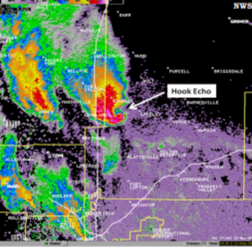
24EXPLORING NATIONAL WEATHER SERVICE RADAR
National Weather Service forecasters
use radar to monitor the type,
movement, and intensity of
precipitation, especially during times of
severe weather. If the radar reflectivity
pattern shows a “hook echo”, this is
a good sign that a mesocyclone is
present and favorable conditions exist
for tornado development. For example,
check out the radar image to the
right of the supercell responsible for
producing the Windsor, CO tornado in
2008.
ENHANCED FUJITA SCALE
Tornado strength is rated by the
damage it causes. The Enhanced-Fujita
scale is a set of wind estimates based
on this damage and assigns a rating to
the tornado that is surveyed.
Fun Fact: Many of
65 - 85 MPH the tornadoes that
EF 0 Light Damage form along the
86 - 110 MPH Front Range come
EF 1 Moderate Damage from non-supercell
110 - 135 MPH thunderstorms,
EF 2 Considerable Damage often called
136- 165 MPH “landspouts.”
EF 3 Severe Damage
EF 4 166- 200 MPH
Devastating Damage
EF 5 OVER 200 MPH
Incredible Damage
25TORNADOES: MYTH VS FACT
Myth: All tornadoes are visible and Myth: Tornadoes do not hit big cities.
look like a classic funnel.
Fact: Tornadoes have hit several large
Fact: Many tornadoes are obscured cities, such as Dallas, Oklahoma City,
by heavy rain and hail (rain-wrapped) Miami, and Salt Lake City. An urban
and may not be visible until they are tornado will have a lot more debris
already upon you! Also, the visible than a rural one.
part of the funnel may not extend
all the way to the ground, while the
swirling winds do. Moreover, the Myth: The southwest corner of the
violent winds of a tornado may extend basement is the safest place to be in
well outside the visible funnel. Finally, during a tornado.
some tornadoes are tall and skinny,
while others are short and wide. Fact: The worst place to be is on
Sometimes they are so large that they the side from which the tornado is
are mistaken for just really low clouds! approaching, which is commonly the
south or southwest side.
Myth: Bigger tornadoes are stronger
and more destructive than smaller Myth: Tornadoes do not develop over
tornadoes. mountains.
Fact: The size and shape of a tornado Fact: Tornadoes can and have
does not say anything about its occurred in the mountains. On
strength. There is no way to know July 7, 2004, a hiker observed and
how strong a tornado is just by looking photographed a tornado at 12,000 feet
at it. in Sequoia National Park, California,
making it the highest ever observed in
the U.S. On July 28, 2014, a tornado
Myth: During a tornado, you should touched down near 11,900 feet in
open all the windows in your home to Mt. Evans, Colorado, making it the
equalize the pressure. 2nd highest elevation a tornado was
observed!
Fact: Opening the windows of your
home to decrease the air pressure
does nothing to decrease the damage.
Instead, it lets the wind in, making it
easier to blow your house apart!
26TORNADO SAFETY
General Safety Tips If Driving
• Seek shelter in a sturdy building • If you are in open country and see
with a basement or underground a tornado, drive away from the
storm shelter. If these options are tornado and its path if time permits
not available, move to a hallway or
a small interior room on the lowest • If the tornado is fast approaching
floor, such as a bathroom or closet and you don’t have time to drive
and stay away from windows. away, you have one of two options.
→ Safest option - Abandon your
• Cover yourself! Wear a helmet to vehicle and seek shelter in the
protect your head. Use blankets lowest level of a sturdy building
or get under a sturdy piece of → Abandon your vehicle and lie in a
furniture such as a workbench to ditch or culvert away from your
protect yourself from flying debris vehicle and protect your head.
(this is the greatest risk of injury However, be aware that tornadic
from tornadoes!). storms often produce heavy
rainfall, which can flood ditches
If in a Mobile Home or RV and culverts. Make sure you
• If you live in a mobile home, have a
plan of where to seek shelter in the know what you are getting into
event of severe weather. and how easily you can get out
of these locations if they flood.
• If severe weather is imminent, • Do not take shelter under an
abandon your mobile home overpass/bridge. By doing so, you
in advance of the storm and are:
seek shelter in a nearby sturdy → Blocking the roadway with your
building or storm shelter. Mobile vehicle. This risks the tornado
homes offer little protection from coming through and turning
tornadoes! vehicles into debris fields, which
will restrict emergency vehicles
from being able to get through.
→ By climbing to higher ground
underneath the overpass/bridge,
you will place yourself at greater
risk from the tornado and flying
debris.
27WINDSOR TORNADO: MAY 22, 2008
While strong tornadoes are not common in northern Colorado, they
can happen. An example is the EF3 tornado that caused extensive
damage to areas in and near Windsor, Colorado, on May 22, 2008. It is
the costliest tornado to date in northern Colorado history, causing an
estimated $193.5 million in damage along a 39-mile track. There was one
fatality, 78 injuries, and at least 850 damaged homes. There were several
characteristics to this tornado event that made it unusual for the region,
including the time of day when it formed, its intensity, its long track,
and its direction of motion. The storm developed in the late morning, in
contrast to the late afternoon when most tornadoes strike. It was also
strong and long-lived, while most tornadoes this close to the Front Range
are typically weak and short-lived. Although we often observe tornadoes
to have an eastward motion to their track, this tornado moved very
quickly toward the north northwest.
Photo courtesy of Weld County OEM
28WILDFIRE
is one of Larimer County’s greatest hazards. For most of our history, Larimer
County’s largest wildfires usually encompassed two to three thousand acres.
However, in the year 2000, the situation changed with the Bobcat Fire at 10,665
acres. Then in 2002, the Big Elk Fire burned more than 4,000 and threatened
the Town of Estes Park. In 2004, the Picnic Rock Fire burned nearly 9,000
acres. In 2012, Larimer County experienced its most destructive fire season on
record with the Woodland Heights Wildfire burning down 22 houses and two
outbuildings near Estes Park, and the High Park Wildfire, which burned 87,250
acres and destroyed more than 259 homes. The High Park Wildfire was the most
destructive fire in Colorado history, in terms of the number of homes it burned,
until it was surpassed by the Waldo Canyon Wildfire in El Paso County in that
same year.
In 2020, Larimer County also experienced what would become the largest
wildfire in Colorado State history, the Cameron Peak Wildfire. This fire ignited
on August 13, 2020, and was not considered 100% contained until almost
4 months later on December 2, 2020, and was finally deemed controlled
on January 12, 2021. This fire had a significant impact on our communities,
prompting evacuations for almost all of the communities of western Larimer
County, including Estes Park when a separate fire, the East Troublesome Fire,
crossed into Larimer County from Grand County. In total, the Cameron Peak
Wildfire burned 208,913 acres and destroyed 469 structures (224 of these being
residential structures).
In the past few decades there has been a proliferation of homes in what is now
called the Wildland/Urban Interface - cluster developments or individual homes
located in the mountainous and forested areas of our county. When these
developments and mountain homes are threatened, our firefighters must divert
attention and resources to saving them and away from the effort to flank and
stop the fire. In the pages following, we will look at emergency preparedness
for fire with a discussion of this problem and what landowners in the areas
potentially threatened by fire can do to make their homes safer.
29WHERE TO GET INFORMATION
It is important during an incident to receive information from
official sources. While tools like social media are great for
accessing information quickly, it may not always be accurate.
If the Larimer County Sheriff’s Office (LCSO) has command
of an active fire, the LCSO Public Information Office is the
most accurate source of information. Most updates will be
posted to Twitter as the information becomes available.
LCSO also utilizes Facebook and Nextdoor to post less
frequent, but more comprehensive reports about active
fires. LCSO may also issue press releases in hopes the local
media will share the information with their readers.
Official Social Media Handles:
Larimer County Larimer OEM Larimer Sheriff’s Office (LCSO)
Facebook: @LarimerCounty Facebook: @LarimerCountyOEM Facebook: @LarimerSheriff
Twitter: @LarimerCounty Twitter: @LarimerOEM Twitter: @LarimerSheriff
WILDFIRE CONDITIONS & FIRE RESTRICTIONS
The Larimer County Sheriff’s Office Emergency Services Unit and local fire
departments/districts monitor potential wildfire conditions throughout the
year. The Larimer County Board of County Commissioners will impose fire
restrictions, when necessary, based on the recommendations of the Sheriff’s
Office and/or any fire chief or fire agency within Larimer County. If fire
restrictions are in place, a notice will be posted on the Larimer County website
at www.larimer.gov.
Regardless of current conditions, community members and visitors to Larimer
County are encouraged to exercise caution with any potential source of ignition:
• Campfires - only build campfires when and where authorized, do not leave
them unattended and put them out completely. Use ample water and stir
until the coals are cool to the touch.
• Cigarette and cigar butts - dispose of lit smoking materials properly.
Heat transfer from exhaust systems - do not park a vehicle in areas with
tall grass that could catch fire.
• Grinding and welding - keep a shovel and fire extinguisher close and ready
to use as these activities can start fires.
• Lawn mowers - metal blades striking rocks can create sparks and start
fires.
30FIREWORKS IF YOU SEE SMOKE
Any fireworks that leave the ground or Immediately call the LCSO non-
explode are illegal in Colorado. Legal emergency number (970) 416-1985.
fireworks include the following:
• fountains Provide emergency dispatchers with
• toy caps the best location of the source of the
• snake or glow worms smoke, where you are, the color of
• ground spinners the smoke, and any characteristics of
• illuminating torches the smoke you can describe.
• dipped sticks and sparklers
• toy propellants
• noise makers that crackle or
whistle, but don’t explode
Note: It is unlawful to furnish fireworks
to anyone under 16 years of age.
Those under 16 are also prohibited by
law from buying fireworks.
EVACUATION
In the event of an active wildfire, the Larimer County Sheriff’s Office may issue
evacuation notices for your safety. This is done via NOCO Alert. If you have a
landline, you will receive emergency alerts on that phone. If you do not have a
landline or wish to receive emergency alerts on your cell phone, visit
www.nocoalert.org to register for free. For more information about evacuation
notices in Larimer County, see page 16.
It is important to note that you do not have to wait to receive an evacuation
order to evacuate. Remember that wildfires are dynamic, and can move really
quickly. If you feel unsafe for any reason, leave the area immediately. Additionally
remember that it can take time to evacuate children, pets, or livestock. If you are
in this situation, it is highly recommended that you leave early, before a mandatory
evacuation order is issued.
31DEFENSIBLE SPACE
(Excerpts Courtesy of the Colorado State Forest Service) Two factors have
emerged as the primary determinants of a home’s ability to survive wildfire.
These are the home’s roofing material and the quality of the “defensible space”
surrounding it.
ZONE 1 ZONE 2 ZONE 3
is the area of is an area of fuel reduction. It is a is an area of
maximum modification transitional area between Zones 1 200 feet around
and treatment. It and 3. The size of Zone 2 depends the structure.
consists of an area on the slope of the ground where It extends from
of 5 feet around the the structure is built. Within the edge of your
structure in which all this zone, the continuity and defensible space
flammable vegetation arrangement of vegetation should to your property
is removed. These be modified. Remove stressed, boundaries.
15 feet are measured diseased, dead, or dying trees
from the outside edge and shrubs. Thin and prune the
of the home’s eaves remaining larger trees and shrubs.
and any attached Be sure to extend thinning along
structures, such as either side of your driveway all
decks. the way to your main access road.
These actions help eliminate the
continuous fuel surrounding a
structure while enhancing safety
and the aesthetics of the property.
ROOFING MATERIAL
Use fire-resistive materials (Class C or better rating), not wood, or shake shingles,
to roof homes in or near forests and grasslands. When your roof needs significant
repairs or replacement, do so with a fire-resistant roofing material. Larimer
County currently requires new construction to have Class A roofs only. Check with
the county building department for further details at www.larimer.gov/building.
Defensible space is an area around a structure where fuels and vegetation are
treated, cleared, or reduced to slow the spread of wildfire towards the structure.
It also reduces the chance of a structure fire moving from the building to the
surrounding forest. Defensible space provides room for firefighters to do their
jobs. Your house is more likely to withstand a wildfire if grasses, brush, trees, and
other common forest fuels are managed to reduce a fire’s intensity. Creating an
effective defensible space involves developing a series of management zones in
which different treatment techniques are used. Develop defensible space around
each building on your property.
32DEFENSIBLE SPACE & FIREWISE
ANNUAL CHECKLIST
Slash from the thinning is Fire extinguishers are checked
eliminated. and in working condition.
Roof and gutters are clear of Branches overhanging the roof
debris. and chimney are removed.
Your escape routes, meeting There is an easily accessible
points, and other details are tool storage area with rakes,
known and understood by all hoes, axes, and shovels for use
family members. in case of fire.
Chimney screens are in place Grass and weeds are mowed to
and in good condition. a low height.
You have practiced family fire Road signs and your name and
drills and your fire evacuation house number are posted and
plan. easily visible.
Trees and shrubs are properly The driveway is wide enough,
thinned and pruned within the and clearance of trees and
defensible space. branches is adequate for fire
and emergency equipment.
An outdoor water supply is Attic, roof, eaves, and
available, complete with hose foundation vents are screened
and nozzle that can reach all and in good condition. Stilt
parts of the house. foundations and decks are
enclosed, screened, or walled
up.
33WHAT IS PRESCRIBED BURNING?
Larimer County is a fire-dependent landscape. This means that fire is a central
component of keeping this landscape thriving, beautiful and resilient. Years of
limiting fires have decreased the important work that fire used to do in reducing
and recycling the vegetation, both dead and
alive, in our forests. This has left forests
with too many trees competing for limited
resources, creating overly dense and
unhealthy forests that can fuel large, high-
intensity wildfires like those experienced in
2020.
Prescribed fire is an important forest
restoration tool that leverages a natural
process to help foster ecosystem health,
decrease future fire risk, and prevent
negative outcomes of fire.
Prescribed fires are planned and
implemented by well-trained fire managers
with a strong understanding of fire and
fire-adapted forests, utilizing on-the-ground
experience and science. Prescribed fire
is a way to use a natural process to ensure
forest health and reduce high-severity wildfire hazards. The choice is not between
no fire and lots of fire, it is a choice between an unhealthy forest and a healthy
one. Prescribed fire is a chance to restore our forests, so they are more resilient
to natural fire in the future.
You can be part of the solution! Take small actions to and around your home to
decrease its exposure to wildfire, such as the tips around defensible space on
page 28. You can also encourage your neighbors or homeowner associations to
invest in similar activities.
Find out more information regarding prescribed fire
practices, forest and watershed health, opportunities to
participate in workshops and tours and more at www.
nocofireshed.org
342020
THE YEAR OF FIRES
Due to such factors as climate change, drought, pine-beetle infestations, and
lack of fire on the landscape from fire suppression policy and resulting forest
overgrowth, we continually see more intense fire conditions, with larger, more
catastrophic wildfires occurring in the western U.S. each year. Prior to 2002,
there was never a fire larger than 100,000 acres in Colorado. In the year
2020 alone, Colorado experienced three of its largest fires in history, all of
which surpassed this number. These include the Cameron Peak Fire, the East
Troublesome Fire in Grand and Larimer Counties, which burned 193,812 acres
and resulted in the death of 2 people, and the Pine Gulch Fire in Mesa and
Garfield counties which burned a total of 139,007 acres.
In addition to Colorado experiencing the three largest fires in its state history,
2020 was a challenging year with fire even here in Larimer County. At the
same time of the Cameron Peak Fire, Larimer County was not only impacted
by the global COVID-19 Pandemic, which caused challenges in sheltering and
firefighting operations, but also experienced complex response challenges
when multiple fires happened at the same time. There was the Lewstone
Fire here in Larimer County that ignited close to Cameron Peak (though
thankfully was extinguished in a few days), as well as large fires that
threatened other parts of Larimer County such as the Mullen Fire in Wyoming
to the North (which eventually reached over 176,876 acres) and the Calwood
Fire in Boulder County to the South (which eventually reached about 10,113
acres), both of which influenced evacuations in Larimer County.
Photo Courtesy of Tracy Hines, Larimer County
35FLASH FLOODS
are the number one cause of death of all thunderstorm hazards, and nearly half
of all flash flood fatalities are vehicle related. Most flash floods are caused by
slow-moving thunderstorms, a series of thunderstorms moving repeatedly over
the same area, or heavy rainfall from tropical storm systems. There are some
cases where flash floods also occur from dam failures, ice jams, or irrigation ditch
breaches. Also, it takes much less rainfall to create flash flood conditions in the
vicinity of an area burned by a forest fire.
Flash floods are dangerous, sudden rises in water levels along streams, rivers, and
creeks above a predetermined flood level. Flash floods can also be rapid flows
of high water moving into a normally dry area. Ongoing flooding can intensify to
flash flooding in cases where intense rainfall leads to a rapid surge of rising flood
waters. Depending on the intensity and duration of the rainfall, the landscape,
and soil conditions, flash floods can develop within minutes or hours. They can
also move with surprising speed, offering little or no warning of approach. Even
without rivers going over their banks, heavy rain can trigger mud and rockslides.
Some rain induced rockslides occur days after heavy rain has lubricated internal
surfaces of rock formations. Such conditions create hazardous situations for
driving in mountain canyons when rocks or debris are washed onto the road
surface. These types of slides have closed both the Poudre and Big Thompson
canyons for days at a time.
Many people underestimate the force and power of water. It takes 6 inches of
fast-moving flood water to knock you off your feet. Flash floods can roll big
boulders, tear out trees, destroy bridges and buildings, and even scour out new
channels. Whether you are driving or walking, if you come to a flooded road, do
not drive or walk through it!
FLASH FLOOD WATCH FLASH FLOOD WARNING
(6-24 hours in advance): Life or (5-60 minutes in advance): Life or
property-threatening weather hazard property-threatening hazard is occurring
possible. Conditions are favorable and now or likely to occur in the near future.
floods are possible, but there is some Move to higher ground or evacuate
uncertainty. Stay tuned for updates. If immediately.
you are in/near the watch, you should
review your emergency plan with your
family and be prepared to take action
if threatening weather approaches. Stay
tuned to your local news or weather
radio for current and expected weather
conditions.
36BURN SCAR FLOODING
Following a catastrophic wildfire, as we saw in Larimer
County with the Cameron Peak Fire and around the state of
Colorado in 2020, the intense heat leaves behind conditions
where vegetation is burned away completely, and soil is
heavily charred. The soil develops an almost wax-like layer
that repels water, and this condition can last for several
years. As a result, when it rains, the water is no longer
absorbed into the soil and instead behaves similarly to water
running across a sidewalk. This potentially leads to flooding
or mudflows, even when rain is light.
Flooding is a hazard that is already very likely in Larimer County, however, the
burn scar from the Cameron Peak Wildfire is over 200,000 acres, which increases
this likelihood of post-fire flooding occurring significantly in Larimer County.
Additionally, areas that typically experience high waters, particularly in the spring
run-off such as rivers, streams, or tributaries, and properties located below or
downstream from the burn areas are at increased risk of flooding.
Larimer County OEM has compiled a comprehensive resource guide
specifically for post-fire burn-scar related flooding. This can be accessed on
our website at www.larimer.gov/emergency.
JULY 20, 2021 | BLACK HOLLOW FLOOD
An example of burn-scar flooding
is the Black Hollow Flood and
Debris Flow that took place in
the Poudre Canyon north of Fort
Collins on July 20, 2021. Heavy
rainfall resulted in a mudflow that
sent a large amount of debris
into the canyon, destroying at
least five structures, damaging
the roadway and taking the lives
of 4 Larimer County community
members.
Photo Courtesy of Larimer County OEM
37EVACUATION
Like wildfires, flash flooding is a rapidly-onset hazard. This means it can happen
quickly and with little time for warning. Therefore, it is important to understand
evacuation orders. Because flash flood potential is heightened due to the Cameron
Peak burn scar in Larimer County, a new evacuation order was issued in addition
to Mandatory and Voluntary Evacuation orders. This new level is known as an
“Imminent Threat” Evacuation order. If this order is issued, it means LEAVE NOW -
there is no time to gather personal belongings, and you should reach higher ground
by any means necessary.
FLASH FLOOD SAFETY
• Do not depend on official warnings • If your vehicle stalls, abandon
reaching you before a problem your car and seek higher ground.
arises. Keep alert to signs of heavy Rapidly rising water may engulf your
rain, both in your location and far vehicle and sweep you/passengers
upstream. Know where higher downstream.
ground is and how to get there
• Do not camp or park your vehicle
• If you suspect that flooding is near streams, especially during
imminent, or if it is occurring, get threatening weather conditions.
to higher ground quickly. Get out
of areas subject to flooding, such as • Be very cautious at night during high
low spots and canyons. water conditions. It is more difficult
to recognize flood dangers and the
• Avoid flooded and rapid flow areas! darkness can disorient you from the
Do not try to cross flowing streams. safest route when trying to seek
safety.
Never drive through flooded
roadways! It takes only 2 feet of
running water to move a vehicle
(even an SUV!). Even if you see
parts of the road on the opposite
side of a flooded area, you do
not know the depth of the water
or the condition of the road
under the water.
38You can also read