LEARNING METHODOLOGY GUIDELINES - APPLICATION OF THE PEDASTE'S MODEL IN DAYLIGHTING RIVERS - Daylightingrivers
←
→
Page content transcription
If your browser does not render page correctly, please read the page content below
LEARNING
METHODOLOGY
 GUIDELINES

APPLICATION OF THE
PEDASTE‘S MODEL IN
DAYLIGHTING RIVERS
Project partners

Authors: Ugolini Francesca, Cavas Bulent, Di Grazia Serena, Massetti Luciano, Mylonas Demetris,
Ozdem Yilmaz Yasemin, Papageorgiou Fouli, Pearlmutter David, Ungaro Fabrizio, Striano Vincenzo

Acknowledgments: DAYLIGHTING RIVERS partnership: Sara Fabbricanti (WREF, Italy), Elvira
D’Ambrosio, Mariella Mazza, Maria Teresa Gambino, Teresa Somma, Sabato Iuliano, Roberta
Iannone, Maurizio Califano, Giuseppe Gioiella, Raffaele Annarumma, Pantaleona Marrazzo, Vincenza
Somma (Sensale High School), Antonis Lazaris, Andrea Theofilou (Rafina Lyceum, Greece), Eleni
Kolovou (PRISMA, Greece), Gonzalo Barbera, Carlos Garcia Izquierdo (CEBAS-CSIC, Spain), Marìa
Germàn Escudero, María Pilar Parras Masa (IES Miguel Espinosa, Spain).

Editing: Pearlmutter David, Ugolini Francesca

Photo of the front and back cover: Vincenza Somma (Sensale High Schools)

ISBN: 9788895597386

2018. Published by IBIMET-CNR, Firenze, Italy.

The European Commission’s support for the production of this publication does not constitute
endorsement of the contents which reflects the views only of the authors, and the Commission
cannot be held responsible for any use which may be made of the information contained therein.
Summary
1.       ECOLOGICAL AND ENVIRONMENTAL DEBT ................................................................................... 1
2.       SCIENCE EDUCATION TO TRIGGER ENVIRONMENTAL AWARENESS ............................................... 3
3.       RIVERS AND LAND AS LEARNING ENVIRONMENT ......................................................................... 6
4.       TECHNOLOGIES FOR LAND USE STUDIES AND PROMOTION ......................................................... 9
     4.1 GEOGRAPHIC INFORMATION SYSTEMS FOR SECONDARY EDUCATION .................................................................. 9
     4.2 LOCATION BASED GAMES IN EDUCATION ................................................................................................... 13
        Location based games ....................................................................................................................... 13
        Location Based Games and Learning ................................................................................................. 13
        Game patterns of LBGs ...................................................................................................................... 14
        Challenges during Design and Play of LBGs ....................................................................................... 15
        Practical guidance on how to construct an educational game targeting river management ........... 15
5. THE LEARNING METHODOLOGY: APPLICATION OF THE PEDASTE INQUIRY BASED LEARNING
MODEL .................................................................................................................................................19
     5.1 WHAT IS INQUIRY BASED LEARNING ......................................................................................................... 19
     5.2 THE FIVE PHASES OF PEDASTE’S MODEL IN THE LEARNING UNIT ...................................................................... 20
        Orientation ........................................................................................................................................ 20
        Conceptualization .............................................................................................................................. 21
        Investigation ...................................................................................................................................... 22
        Conclusion.......................................................................................................................................... 23
        Discussion .......................................................................................................................................... 23
6.       THEMATIC MODULES AND LEARNING UNITS ...............................................................................25
     6.1. IMPLEMENTATION OF THE MODULES ........................................................................................................ 25
     6.2 NEW LEARNING UNITS ........................................................................................................................... 28
7.       EVALUATION OF THE EFFICACY OF THE MODULES AND LEARNING UNITS ...................................29
8.       SYNERGIES BETWEEN THE PROPOSED INQUIRY BASED LEARNING MODEL AND CITIZEN-SCIENCE
         31
9.       ANNEX 1 - EVALUATION TOOLS ...................................................................................................33
10. ANNEX 2 – EXAMPLES OF LEARNING UNITS .................................................................................34
11. REFERENCES .................................................................................................................................68
1. Ecological and environmental debt
Vincenzo Striano

In the past decades, the available natural resources have decreased exponentially. We are building up a
real, massive ecological debt, which should worry us much more than public debt.
Fresh water used to be seen as an inexhaustible source but, since the mid 80’s, its consumption has been
faster than its natural cycle.                                                                                    1
Each year, the Global Footprint Network determines Earth Overshoot Day: “Earth Overshoot Day marks
the date when humanity’s annual demand on nature exceeds what Earth can regenerate in that year. In
1987 that day was December 19th. In 2000 it was November 1st. In 2017 it was August 2nd. Humanity is
currently using nature 1.7 times faster than ecosystems can regenerate. This is like using 1.7 Earths every
year”.

                                                     EARTH OVERSHOT DAY
                                                                                          The Earth
                                                                                          Overshoot day
                                                                                          (red number)
                                0                   22
                                                                   50                     marks the date
                                                                                          when humanity’s
                                                                             151          annual demand
                                                                                          on nature
                               365,00                                                     exceeds what
                                                343,00
                                                                                          Earth can
                                                                 315,00
                                                                                          regenerate in that
                                                                                          year.
                                                                           214,00

                             1980
                                              1987
                                                               2000
                                                                          2017

       = Ecological and environmental debt (days)

However, it is not only a matter of numbers and theory; in fact, among concrete and visible effects is the
disappearance of rivers and lakes. The flow of the Nile and the Indus river has visibly decreased. The
Yangtze (or “Blue River”) and the Huang He (or “Yellow River”), which used to be among the six longest
waterways in the world, today hardly reach the sea. The Colorado river and the Rio Grande do not even
reach Mexico, ending in the USA. Not to mention thousands of small rivers and water streams dried out
in the last years. The situation is not different for lakes (drastic reduction for the Aral, Chad, Owens etc.).
There is a generalized tendency to waste water resources, but it’s fair to point out that 11% of the world
population consumes 88% of fresh water. Intensive agriculture and animal rearing are among the main
causes of the disappearance of water resources, together with diets based on food produced using
massive quantities of water. Water itself is essential and irreplaceable for all living forms. Farming alone
uses on average 70% of the available water resources. But there is more. According to the FAO, about
1/3 of the food that is produced on our planet goes to waste, and every year, the amount of food Italians
throw into the garbage would be sufficient to feed 3/4 of the country's population for an entire year. It is
a paradox, but in the world the number of deaths caused by malnutrition and those caused by overeating
and poor nutrition are more or less equivalent.
It’s mainly the rich who waste resources, and it’s mainly the poor who see their living condition worsen
drastically. According to the “Lancet Countdown on Health and Climate Change” report, drafted by the
Health World Organization, a billion of climate refugees are expected within 2050.
There is also a further aspect complicating the scenario. The demographic growth is encouraging a rising
    concentration of the population in big cities. In 2009, the number of people living in urban areas overtook
    the number in rural settings. Following this trend, in 2030 about 3/4 of the world population will be living
    in cities, making accessing water extremely difficult.
    All this is not caused by the natural evolution of the planet, but it’s the consequence of human behaviors.
    We must change our lifestyle, and this will not happen thanks to moral calls, but rather by raising public
    awareness and educating the citizens. Starting from the younger ones.
2
    The path to build a culture that prioritizes the fight to ecological debt is long. Both the macrocosm of
    major, universal issues and the microcosm of our everyday life can be great starting points to introduce
    projects on the theme of environmental education, and to understand the strong impact each of us can
    have. The relationship between man and nature needs to be the main focus. For instance, it is very
    important to educate students on the anthropic cycle of water. Visiting your local industrial water
    treatment plant offers an opportunity to learn how complex the process of potabilization and depuration
    is. You also learn to drink from the tap instead of plastic bottles, taking part in the fight against CO2
    pollution. The most effective way for students to learn is through active participation and practical
    experience. It is interesting to experiment with new teaching methods that involve not only scientific
    subjects but also arts and humanities. For instance, for one of our projects with schools, in collaboration
    with the Centre for Contemporary Art Luigi Pecci (Centro per l’Arte Contemporanea Luigi Pecci) based in
    Prato, we used work from “Studio Orta”, a group of fashion designers and performers carrying out
    multimedia research, who have successfully exhibited their minimal habitats, tackling themes such as
    water scarcity and climate migration https://www.studio-orta.com/en/artwork/278/OrtaWater-Zille-
    Fluvial-Intervention-Unit
    They displayed bikes or canoes decorated with plastic bottles and equipped with microsystems for
    mechanical potabilization. All these elements symbolize the experience of migrants who have to flee
    destruction and waste. Paradoxically, waste becomes an accessory and a floating support. These are
    complex, rigorous and disturbingly beautiful structures, which are not made to be reassuring, but to raise
    issues and awareness.
    Water Right Foundation deals with environmental education, working with thousands of students and
    teachers every year. The Erasmus+ Daylighting Rivers project has been a great opportunity to tackle
    issues that were only addressed within local contexts and deal with them in a European dimension, so as
    to build international partnerships and relationship networks, and to experiment new methods to introduce
    young citizens to civic training.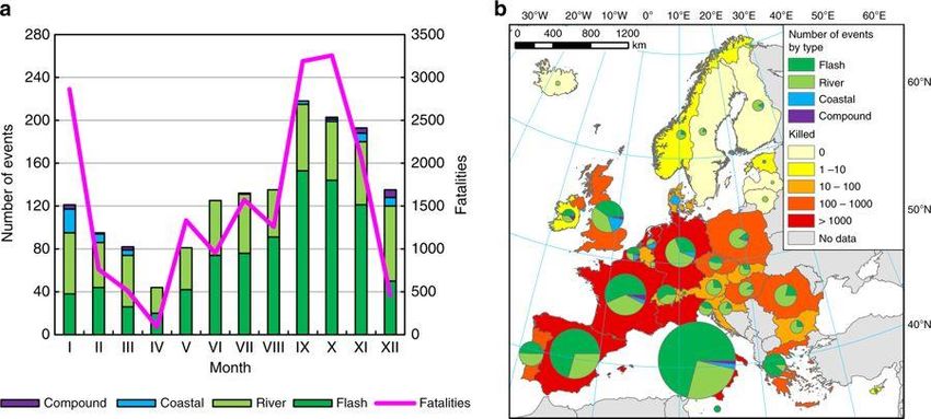
2. Science education to trigger environmental awareness
Francesca Ugolini, David Pearlmutter

       One of the greatest educational challenges in this century is to prepare young people with the
scientific basis they need to understand rationally environmental issues, in the hope of initiating a societal
process of environmentally responsible behaviour. This challenge is especially acute if we consider that
Europe faces a shortfall in scientifically knowledgeable people at all levels of society, and a decrease in      3
the numbers interested in pursuing science-related careers (SIS.net 2012, Bøe et al. 2011, National
Academy of Sciences 2007, European Commission 2004).
       The scarcity of interest among students for science-related pursuits may be due to various
sociological and personal factors, among which are the perception of scientific subjects as difficult and
not connected to their lives, and the lack of stimulation in conventional approaches to teaching. Relatively
few appreciate the extent to which science can enrich their lives, by helping them to understand natural
phenomena and interpret changes going on around them, and to find solutions to specific issues. Young
people with a basic science background are likely to be more keen about understanding how things work,
and more responsible for their own behaviour, because better able to manage risks; thus they should find
it easier to access job perspectives.
       Moreover, innovation and technological development are constantly entering our lives, indicating
how science, technology, engineering, and mathematics (STEM) will impact everyday life, not only in
science based careers. The knowledge of science has not only a conceptual importance, but also a social
and economic development utility (Haas 2005).
                                                         Another important aspect is the responsible
                                                  citizenship (SIS.net 2012) that science knowledge may
                                                  foster. Decision making processes should be informed by
                                                  knowledge that originates from scientific methods and
                                                  evidence, and since nowadays there is an increasing
                                                  attention toward the participatory processes in decision
                                                  making, citizens should be more aware and confident in
                                                  understanding complex scientific topics in order to
                                                  participate with their personal opinion and critical
                                                  thinking.
                                                         Science education starts in the schools – where
 Source: Papageorgiou et al., 2015a.              students can experiment, get their first experience on
                                                  scientific methods, and be inspired in investigations.
Therefore, the use of engaging methods in science teaching, such as Inquiry based learning (IBL), is
fundamental. IBL nurtures students to be responsible for their own
learning process (Pedaste et al. 2015, Kaltman 2010), enhances their
interest in science (Bruder and Prescott 2013), and makes it easier
for them to envisage of a science-related future career (Di Fabio et
al. 2013).

       The assumption is that learning is enhanced when students are
asked to build their own solutions, and when they acquire practical
experience by doing. However, teachers support the students’
thinking by posing questions without pre-judging their ideas or
answers, with the goal of sharpening students’ curiosity and
reasoning skills.
In complex projects like this one, in order to be successful in the acquisition of knowledge and skills
    (i.e. competence acquisition), the students’ interests and prior knowledge should be identified. For this
    reason, prior to the implementation of the project with the class, students and teachers fill in the survey
    (IO1) (links available in the Annex). The survey is designed to assess the respondents' basic level of
    knowledge on the project topics, to define their main interests, and to identify students with specific skills
    or interests that may play specific roles for the overall success of the project.
4           A guided learning process in which the teachers act as facilitators, without giving the correct answer
    but rather supporting the students in achieving their own findings, can produce very positive results during
    the practical experience (Almuntasheri et al. 2016). Some
    authors think that an open-inquiry thinking raises their logical
    thinking skills (Berg et al. 2003; Germann et al. 1996).
    Therefore, most challenging for teachers is posing these
    questions, to enahnce students’ thinking and stimulate them to
    investigate and find solutions.
            Most often, IBL activities are used for understanding
    basis concepts in physics, chemistry and biology, for which
    students can experiment with materials and variables to
    understand a specific concept in one lesson. In contrast,
    DAYLIGHTING RIVERS offers thematic modules that address
    the understanding of more complex systems (e.g. river
    ecosystem, soil properties, effects and impacts of land use,
    river etc.). Scientific investigations, including hands-on
    activities, land use studies etc., will allow students to construct
    their knowledge and also raise their environmental awareness.
    Hopefully, this will be achieved by applying structured IBL in
    order to allow teachers to have a better awareness of the
    knowledge level of the students before starting, and the cumulative effect on knowledge, skills and
    environmental awareness that investigations without preconceptions between genders or different
    ethnicities will bring.
                                                                    Moreover, outdoor learning in a natural or
                                                            semi-natural environment is foreseen in strict
                                                            connection to areas that students know. Outdoor
                                                            learning enhances not only educational achievement,
                                                            but also environmental awareness, natural science
                                                            skills, cooperative behaviour and social cohesion
                                                            (Ofsted 2008; Natural England 2012) – and this
                                                            seems especially effective for young people living in
                                                            urban contexts (Thomas and Thompson 2004;
                                                            England Marketing 2009). Another important aspect
                                                            that DAYLIGHTING RIVERS takes into consideration
    is the use of technologies for studying, investigating and communicating the project results and knowledge
    acquired during the project.
    Nowadays the use of technologies is prominent in everyday life and in work. Learning how to use software
    and devices is useful for acquiring knowledge and skills based on logical thinking, and for communicating
    independent findings in a different way. DAYLIGHTING RIVERS offers the opportunity to work with
    Geographic Information Systems (GIS) and to develop Location Based Games (LBG).

          Besides the more engaging teaching methods, DAYLIGHTING RIVERS suggests a partnership in
    which teachers and students can collaborate with scientists and experts in the professional fields related
    to the project themes. There is evidence that the presence of scientists in the schools is beneficial not
only for the students but also for teachers and scientists themselves (Teachers-Scientists Partnership
report, 2010). The TSP project (2008-2010) identified the following benefits: for teachers: i. knowledge
transfer and understanding of real-world and new scientific discoveries; ii. opinion exchange; iii. access
to resources (papers, presentations, didactic materials, scientific instruments etc.); for scientists: i.
improving methods of communication with students; ii. increasing motivation and enthusiasm in their job;
iii. understanding better the community’s awareness and perceptions of science, scientists and their work.
Finally, students: i. acquired knowledge and understanding of basic research and applications for problem 5
solving; ii. had opportunities to experience real science with real scientists; and iii. increased awareness
of the types and variety of science and technological careers.
Thus, the main objectives of DAYLIGHTING RIVERS are:
- To increase the awareness, confidence and understanding of phenomena using the scientific
method;
- To enhance the educational experience by making science connected to students’ local territory;
- To support cross-disciplinary learning between scientific subjects, art and history;
- To develop skills in practical activities and technologies; and
- To develop soft skills like group work and communication.3. Rivers and land as learning environment
Serena di Grazia
People are strongly tied to the landscape with emotions (Davidson et al., 2009) that increase
interest and awareness for landscape studies, regardless of their age. Indeed, rivers have a strong imprint
on the territory and historical importance. Understanding the dynamics of interaction between man and
6 nature is useful for developing a critical appreciation of rivers and their many aspects the topics, and this
can be accomplished through comparison between the different ways that people have responded to
changes in the river system at different times (e.g. in the past and in the present).
The fluvial dynamics as well as the technological, economic and social development of civilization
are linked to water courses. The study of the water courses relates to different places, since the entire
river basin is regulated by river dynamics. For instance, upstream engineering interventions have an
impact on the valley, and dams and hydraulic modifications on the tributaries interfere with the river
behaviour. The river's reaction to man's actions offers insights for the analysis of nature and man. Studying
the river makes possible new knowledge to raise, like the history of the landscape and the culture of a
place.
Topics like the ones listed below deserve more attention by all generations, and at the high school
level they can be approached in not only in STEM but also in humanistic subjects. Moreover, inquiry-based
learning methodologies allow tackling problems through interactive methods and techniques, to reach a
deeper knowledge by description, quantification and calculation of important parameters. This new
knowledge, acquired also with a direct contact with the river system, is consistent with the cultural
awareness that should be acquired in high schools.
Hydraulic hazard
The presence of a river in a town can cause
floods and the presence of covered rivers increases the
hydraulic hazard. The water inside covered rivers flows
into concrete walls and does not infiltrate as
groundwater. In case of a heavy rain, the water that
previously flowed into a big river bed goes straight into
a narrower underground channel – usually less than
twenty meters wide – that is not suitable for extreme
amounts and for this reason, it can cause floods in the Source: www.noaa.gov
urbanized area. Every year, floods in urban areas
cause massive deaths and damages.
Moreover, with the climate changes recorded during the last decades, the amount and the
distribution of rains has changed, and the size of the covered rivers built from the 19th century onwards
is no longer adequate.
The perception of the danger is linked to the memory of disasters like floods and to the view of the
river which grows rapidly during the rainy season, so that the different levels of risk can be assessed.
However, the flooded rivers hide river dynamics – so even if citizens do not have direct perception of
danger, the awareness of their presence in the territory increases the perception of danger.
Geomorphology
The territory is shaped by the water courses and the river dynamics give it specific characteristics.
Hydrological studies increase awareness of the slow evolution of nature that follows the river course with
a force and constancy to which man must relate and adapt.
Climate change and daily behaviorThe river is an element of the landscape and the changes made by both man and climate change
are easily recorded (Palmer, 2008). Drought decreases the water flow and increases the concentration of
chemical and bacterial pollutants in water, causes eutrophication etc. On the other hand, a different
distribution of rains with extreme events causes hydrogeological disruptions and affects directly the
amount of water flowing in water courses. Therefore, studies on rivers, including the water management
in urban areas and hidden rivers, can be useful for the assessment of climate change impacts and to
understand how the territory can be more resilient. 7
Management of the water course
Man's intervention on the rivers may influence the territory at river basin scale, affecting also the
landscape, and at a wider scale when places in more than one country are involved. The environmental
planning involves all inhabitants of a river basin, and therefore any intervention in a territory, rather than
being limited to the political boundaries, needs to consider the whole river.
Moreover, urbanization has strongly affected the flow of rivers in cities: river beds in and around
towns have been channeled, drained, diverted or culverted, generally to create new infrastructures such
as roadways. These "hidden" rivers are part of the natural drainage system, but they are flowing
underneath concrete streets.
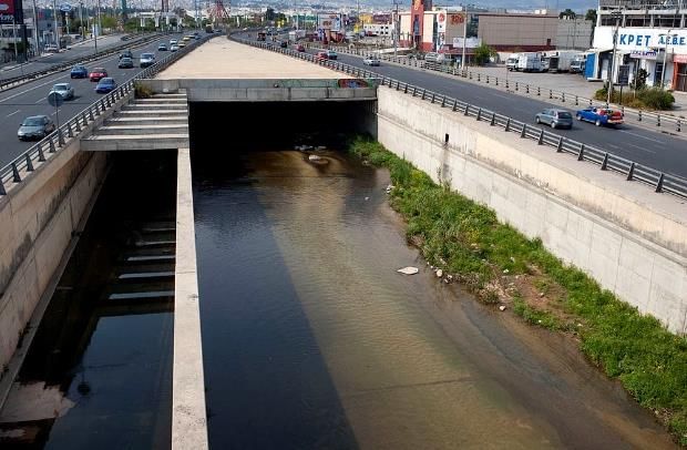
The hidden rivers in the territory
Hidden rivers can be of different types. There are
streams that have been covered to build roads, there are
sewage systems that collect surface water, and much
more. Memory has been lost in many of the rivers.
Cartographic research by students can be a way to foster
the awareness of young people toward the topic and
increase their knowledge of the territory.
This is also important in connection to climate
change, which often causes alternating periods that
fluctuate from extremely dry conditions to heavy rains,
which suddenly increase the river flow with consequent Cephissus river view under the highway
enormous hydraulic risks. Athens-Lamia. Source: Wikipedia.
A recently published study (Paprotny et al. 2018)
has analyzed flood events from 1870 up to 2016 in all Europe. The study indicates that there has been
an increase in annually inundated area and number of persons affected since 1870, and three
Mediterranean countries (Italy, Spain and France) count the highest number of flood events (especially
Flood
occurrences and
fatalities. Total
number of flood
events and
fatalities
between 1870
and 2016, a by
month and b by
country. Source:
Paprotny et al.
2018, Nature.flash floods) with a higher frequency between September and November – while central and western
Europe countries count more river floods concentrated between June and August.
Land planning
Planning is not just about making a physical change, but also transforming people's emotional vision
of the landscape (Balmori, 2014). In DAYLIGHTING RIVERS, students’ planning is based on the definition
8
of "landscape quality objectives" – that is, a detailed indication of the characteristics that students would
like to see recognized in a familiar place. Everything changes in such systems, and the action of man is a
dominant vector (Ghersi, 2005).
Based on these issues, DAYLIGHTING RIVERS aims to create a young community that is sensitive
to the issue of rivers, and to encourage the acquisition of knowledge, capacity to design basic research
studies and practical solutions for saving river ecosystems but also raising awareness of the importance
of rivers over a wide range of aspects. Through Learning Units in natural and urban environments and
thanks to the contribution of urban/landscape architects and scientists, DAYLIGHTING RIVERS also fosters
youngsters’ curiosity on the hidden rivers in their town and stimulates design solutions for their
daylighting.
To address this general and long-term objective, DAYLIGHTING RIVERS aims to produce leaning
modules based on Inquiry Based Learning (IBL) in contexts familiar to the students. In this way, it aims
to attract students to science and at the same time, raise their awareness on urban sprawl, land use
changes and issues connected to rivers.
Source: Rafina Lyceum (Greece)
http://zogaris.blogspot.com/2018/10
/rafina-river-environmental-4. Technologies for land use studies and promotion
4.1 Geographic Information Systems for secondary education
Fabrizio Ungaro
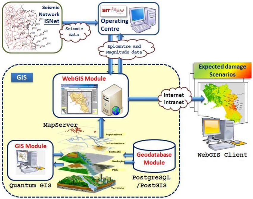
The feature that makes Geographic Information Systems (GIS) particularly interesting to
educators is its ability to dynamically represent the world and its issues from a variety of spatial 9
perspectives (Audet and Paris 1997). Fitzpatrick and Maguire (2000) describe GIS as a set of integrated
software programs designed to store, retrieve, manipulate, analyze and display geographical information.
Currently the availability of web-based GIS (i.e. a module allowing connection with a remote map server)
has expanded the classical GIS architecture (i.e. a geodatabase module coupled with a GIS module),
combining the advantages of both the Internet and GIS. Web-based GIS allows users not only to add and
remove layers of data, but also to collect, process, analyze, interpret, visualize and communicate them,
and to achieve client-server interaction (figure below).
Example of a
Geographical
Information
System (GIS)
logical
architecture: GIS
modules are
represented inside
the dashed box, to
differentiate them
from other
subsystems they
connect to via
internet (From
Pollino et al.
2012).
As a technology, GIS has the capability to expand the topics students can explore virtually to a
limitless extent, promoting interdisciplinary learning and changing the way students approach and think
about the geographic space and the objects it contains.
The use of GIS tools fosters the development of geospatial thinking competences, enabling the
students to:
1. Develop spatial thinking skills: spatial visualization, spatial orientation, and spatial relations;
2. Critically read and interpret cartographic data and other visualizations of geospatial objects and
their relationships in different media;
3. Be aware of geographic information and its representation through GIS;
4. Visually communicate spatial information, developing a language to transmit and exchange basic
geographic information with others ;5. Describe and use examples of GI application in daily life and in society, relating the features of
the geographic space and their changes to the past and current dynamics in society;
6. Tackle a number of spatially based problems, address conflicts at different spatial scales from
local to global, and explore space-dependent dynamics over time from a multidisciplinary
perspective;
7. Use (freely available) GI interfaces and Web-based map services along with other kinds of mobile
10 devices (smartphone, tablets).
Typically when assessing the role of GIS in secondary education, the first distinction is that between
teaching and learning about GIS, and teaching and learning with GIS (Sui 1995). Teaching and learning
about GIS focuses on the development of students’ knowledge about the system and spatial data and the
development of skills in using GIS, while teaching and learning with GIS focuses on the development of
students’ geographic knowledge and geographic thinking skills. According to Meyer et al. (1999) the focus
should be on “using GIS to learn how to do geography”, rather than on “learning how to use the
technology”. Today most educators believe that geography education should put more efforts on teaching
and learning with GIS, rather than teaching about GIS (Lemberg & Stoltman 2001; Kerski 2003; Bednarz
2004). Neverthelss, some authors (e.g. Johansson 2006) claim that it is necessary to teach students first
about GIS before they can engage in learning with GIS.
Education with GIS can then have different forms: (1) teaching about GIS; (2) teaching with GIS; (3)
learning with GIS; and (4) inquiry with GIS. In teaching about GIS, teachers tell students about what GIS
is and how GIS works. In teaching with GIS, teachers use GIS with a digiboard or a projector and a
screen, in order to illustrate their talks about specific themes, regions, or geographic problems.
Educational WebGIS software and Virtual Globes are very suitable for this kind of teacher-centered
education. In learning with GIS, students work on short GIS-based lessons in the computer room. This is
a more student-centered kind of education. The fourth and final form of education with GIS is inquiry with
GIS. In this case, students are challenged to tackle real life problems within a specific spatial domain using
GIS to find solutions via iterative cycles of designing, testing, and evaluating, together with teachers.
The processes adopted when answering geographic questions (Favier 2011). Notes: i, internal operations; E,
external operations.This iterative process allows the students to see how GIS integrates as part of the wider cycle of problem
– evaluation – solution loop. This is shown very clearly in the above figure (Favier 2011), while the
following table summarizes the types of question usually addressed by GIS enquiry.
Step What to do Type of Knowledge
Construction
Ask a geographical Ask question about the Enquiry 11
question world around you
Acquire geographical data Identify data and Inventory
information that you need
to answer your questions
Explore geographical data Turn the data into maps, Spatial processing and
tables graphs and look for analysis
patterns and relationships
Analyze geographical Test a hypothesis, carry Spatial Analysis, Modelling,
information out map, statistics, written Decision making
analysis using evidence
The types of question usually addressed by GIS enquiry.
Numerous studies have documented the increase of GIS tools in secondary education around the
world: according to many authors, (Audet and Paris 1997; Bednarz and Ludwig 1997; Johansson 2003;
Landenberger et al. 2006; Kerski 2008) GIS supports constructivist teaching and learning strategies such
as problem-based and inquiry-based learning. Furthermore, the use of GIS provides opportunities for
issue-based, standards-based, and student-centered education in classrooms (Kerski 2003). Nevertheless,
recent studies (Kerski et al. 2013) highlight that although the current use of GIS tools in secondary
education remains small, there are chances of greater increases in the number of schools, teachers and
students using GIS. This is mainly due to the convergence of citizen science, emphasis on spatial thinking,
the widespread use of mobile devices, the accessibility to open data and the spreading of Web-based
map services (Kerski et al. 2013). According to Demirci et al. (2013) though, the use of GIS as an
educational technology is hindered on the one side by technological obstacles (e.g. lack of quality data,
GIS software, and internet infrastructure) and on the other by pedagogical difficulties, (e.g. teachers’
limited knowledge, skills and experience about GIS). Bednarz (2004) highlighted that Teachers appears
to be ‘the weakest link’ and a serious component limiting diffusion of GIS in secondary education.
In DAYLIGHTING RIVERS teachers are trained in the use of GIS, and GIS based activities with
students will be developed during the school year. The focus of training and educational activities will be
in the development of spatial thinking skills related to spatial relations, such as those reported in the
following table:
Skills for spatial relations Process used in cognitive
mapping and GIS
Recognizing spatial distribution and spatial patterns Constructing gradients and
surfaces
Identifying shapes Layering
Recalling and representing layouts Regionalizing
Connecting locations Decomposing
Associating and correlating spatially distributed Aggregating Correlating
phenomena
Comprehending and using spatial hierarchies
Regionalizing Evaluating regularity or
randomness
Comprehending distance decay and nearest neighbor Associating
effect in distributions (buffering)Way finding in real world frames of reference Assessing similarity
Imagining maps from verbal descriptions Forming hierarchies
Sketch mapping Assessing proximity
Comparing maps Measuring distance
Overlay and dissolving maps Measuring directions
Defining shapes
Defining patterns
12 Determining clusters
Determining dispersion
Examples of spatial thinking skills.
Students will be asked to identify a problem in their area related to the environmental status of
rivers and its implication at ecological, social and economic levels, and to determine a (Web)GIS project
topic to help design solutions to these problems.4.2 Location Based Games in education
Demetris Mylonas and Fouli Papageorgiou
Location based games
Hide and seek, I-Spy, police and thieves, role playing games and capture-the-flag games have all
been popular real-life location-based games that have been played in different versions across the globe.
These games allow the players to refer to physical objects and location(s) and use their creativity and 13
imagination in order to interact meaningfully with others, as well as with the location(s). In recent years
there has been a rise in the number of creative games, interactive narratives and playful activities that
are facilitated by mobile devices in such a way that the game activity follows the players’ location. A term
used to describe such games is “mobile location-based games”.
The advent of mobile devices, such as smartphones and tablets, and the fast evolution of game
technology, provide great opportunities to develop place-based games that encourage participants to
become immersed in playful and meaningful interactions, using different layers of information. These
products also offer real opportunity for learning and storytelling about specific locations and routes,
introducing the natural or built environment as a participant in the players’ interaction and experience.
New media, such as internet-connected mobile devices, enable instant social networking, micro-
blogging and video sharing, all of which are being widely used by young people. The nature of these
media and the applications used, possibly more than their content, have greatly influenced the way the
younger generation and society at large think.
In recent years, advanced mobile devices have made the use of location-based services very
convenient. Location-based Services (LBSs) are IT services for providing information that has been
created, compiled, selected, or filtered taking into consideration the current location of the users or other
persons on mobile devices. With the expansion of location-based services, location-based games have
also gained in popularity and become more widespread.
Many applications for modern smartphones incorporate LBSs to provide location-based
information. This information can be used to give location-based advice, navigation directions, to track
movement and conveniently communicate one’s current location to friends, etc. However, it can be also
used in the fields of entertainment and learning, to create games that make the position of the player an
essential part of the gaming and learning process.
A location-based game (LBG) is defined as a form of play designed to evolve on a device in
motion, directly linking the game experience with the location of the player. To create a location-based
experience, usually a connection to other devices, e.g. a server or other players, is necessary. However,
it is also possible to run single player games, provided that all required information is stored in the player’s
device. In this case, a connection to other devices is not necessary to run a LBG, as long as the game
follows the changing locations of the player’s device.
Location Based Games and Learning
Location-based gaming offers great educational possibilities, as it allows educators and facilitators
of learning to create constructivist experiences rich in educational content (Papageorgiou et al. 2015a,
2015b). The proliferation of LBGs is due to the widespread use of mobile devices, like smart phones and
tablets, with advanced location sensing capabilities, as for example GPS satellite positioning. LBGs can be
compelling for young players as well as adults. Video games are, by their very nature, built around
interaction and participation. Therefore, they provide a tool for designing curricula that offer more than
mere exposure to content, aiming to enrich student experience through engagement and active
participation. LBGs offer an additional level of experience: due to the fragile border between games and
real world activities, and because of the resulting changes in the game experience, players becomeinvolved and associate with the LBG, thus gaining stronger emotions and satisfaction from well-designed
LBGs.
Mobile games are particularly suited to creating educational experiences in informal settings.
Mobile media and augmented reality can fruitfully combine the advantages of educational video games
with place-based learning.
LBGs offer great opportunities to include educational content in the playful experience by using
14 context-aware learning tactics and content generation mechanisms like augmented reality, embedded in
a mobile device game or triggered by simple technologies such as QR codes and RFID.
LBGs have another important feature, which makes them valuable for education: they connect
places and stories. In a LBG, it is possible to embed extra layers of information and narratives about, for
example, the route of an urban river or other locations of environmental importance. By visiting real
places, the story becomes a personal experience linking physical objects with learning content. This
conveys to the player location-specific knowledge, which is easy to remember, exploiting the connection
between the real world and the game.
Game icon on a game-map (left), example of text produced by school kids for a plaque (descriptive form) of a
game stop (centre) and game items (right).
Game patterns of LBGs
A useful classification of potential game patterns in LBGs is outlined below:
A. Search-and-Find
In Search-and-Find games the player has to search for a specific geolocation in order to progress
in the game. This can be made possible either by suggesting the rough location to be visited using a map
in the game interface; or by giving a clue referring to the surroundings e.g. a building, a road feature or
a landmark. In such games the player can choose from a range of proposed locations or move towards
the single location suggested. Reaching a destination is the main objective behind Search-and Find Games.
An example of this game-pattern is Geocaching in which the player moves to a specific location in order
to find a hidden physical object, usually a box containing items, then takes one item out of the box and
leaves back another item in replacement to the one the player removed. GPS coordinates provide the
location for the next “geocache” to be discovered.
B. Follow-the-Path
A Follow-the-Path game is quite similar to a Search-and-Find game with the only difference being
that a destination is not the goal, but the sequence of destinations is, and how the player reaches them.
Any deviation from the defined route can result in penalties for the player i.e. missing a reward/item/clue.
Treasure Hunt is one of the most popular Follow-the-Path games.C. Chase-and-Catch
In Chase-and-Catch games the players try to find a moving virtual target and claim it: this target
can refer to the actual location of another player or the changing locations of a moving virtual object that
exists only in the game world. The player is informed about the location of the target via the game
interface/ interactive map and the aim of the game is to approach the target quickly to “catch” it. This
game-pattern promotes strategy building and physical activity while it can involve a single player or be a
multiplayer gameplay. Ingress is an augmented reality territorial version of the Chase-and-Catch game 15
type.
D. Change-of-Distance
Change-of-Distance games use the notions of proximity or remoteness between the player’s
location and several geolocations within the game; the location itself or the direction of the player’s
movement are not as important as the movement of the player. The player’s goal is to either move
towards a location or move further away. An example of this pattern is The Journey: in this game the
actual location of the player does not influence the plot, however the movement and the journey of the
player are tracked, as well as the locations already visited.
Challenges during Design and Play of LBGs
The very nature of LBGs, being placed in the physical world and using actual locations and places
as their backdrop, poses several challenges to both designers and players, such as energy consumption,
network coverage or GPS accuracy.
A. Energy Consumption
Using GPS on a mobile device while being connected to a wireless Internet at the same time
results to high-energy consumption in most devices. Shorter game sessions and offline intervals or content
introduced through QR codes can reduce the energy demands of an LBG.
B. (In)-Accuracy of Positioning Systems
Bad reception of GPS signal or inaccuracy of positioning systems can cause interferences to the
player’s experience. A strategy that may efficiently address this problem is to increase the range of the
geolocated virtual objects so that a non-accurate location would have fewer possibilities to interfere with
the gameplay.
C. Inadequate wireless internet reception
Bad signal, although limited nowadays in most EU countries, is not unusual especially in natural
areas and in some urban areas as well where 3G or 4G coverage is poor. Testing the signal of different
providers on-site with mobile devices before starting the game could prove useful for two reasons: firstly,
to define the field of action for the game more precisely; and secondly to choose a provider that offers
the best coverage. Portable hotspots can also come in handy for data sharing in such cases.
However, if the group of designers preferred to create an offline game, either because data pack
plans can be expensive or because portable hotspots can be slow, an alternative would be to use QR
codes. This is a feasible option if the would-be game designers wished to avoid internet coverage
restrictions, being willing, at the same time, to settle for text-only game content.
Practical guidance on how to construct an educational game targeting river management
Before starting designing a game one should think about the following questions:
• What is the goal of your game?
• Is there a learning objective? How will you accomplish it?• How many users and age groups will be involved?
• How long will the game last?
• What game mechanics will you use (points, scoreboards, escalation, narrative goals)
• Will your game require Wi-Fi /3G coverage? Will you use QR codes instead?
In order to better understand the process of game design, a set of issues that are integral to the design
16 process are presented:
Field trips: Throughout the completion of the project you will have the opportunity to visit the river
course several times. Make use of those visits and take advantage of the walking tours with experts.
People like telling stories while wandering around. Also, keep in mind that this also works vice versa:
Game mechanics can encourage wandering around!
Inquiry: Do not hesitate to ask experts and teachers about issues related to river management. Use their
expertise in order to accurately identify the issues regarding the river of study, and inquire about past
experience, best practices in your country and elsewhere, and proposals for possible intervention. One of
the best practices possible is to discuss and inquire about issues in the location where they are most
evident.
Choosing game genres and narrative: People sometimes feel demotivated to play alone or get easily
bored when playing by themselves. A cooperative or competitive game between teams can provide a
solution to this problem. For several locations it might be practical to create games for solo players that
enjoy strolling around at their own pace and discover the game. Learn about game types, ways to motivate
the player and storytelling by examining video-games, street games, traditional games and interactive
storytelling experiences.
Game Mechanics: Simple is beautiful! Don’t use too many mechanics and too much text. Try to design
an interactive and emotionally moving system/game/story.
Think of all the simple but truly beautiful games you have experienced and you will understand that the
fun in the game does not lie in its complexity. Think as a player when you design the game and avoid
long texts and excessive information. Concentrate on the issues at hand and the message you want to
get through and try to use as few game mechanics as possible. Get inspired by the issues themselves and
games that you love and create a new experience for your users.
Storyboarding: “Plan First, Play Later!” Paper prototypes are an easy way to get feedback on multiple
ideas. A script is always useful when trying to get a story through. Prepare your plot by writing a script
and use paper prototypes before digitally designing your game. Share your idea with friends and
classmates and check if it makes sense and keeps them interested before implementing your game.
Implementation: Use the help offered by the game-design platform you select (tutorials, forum, help
desk etc.). Don't be afraid to ask your teammates and make mistakes. Remember that the platforms are
free and might contain bugs. Don't lose heart! Creating a piece of software and debugging it, even in
such a simple and user-friendly way, requires patience.
Playtesting: Playtesting is the most important phase of game design. This is where a game shows its
potential and ideas are tested in action. Do not be afraid to fail. Fail fast and try to fix the problematic
points or redesign. Run the game within its actual context on site if possible. Test out core mechanics
before emulating the final game.
Environment: The game you have to design has a significant feature that you cannot ignore: it is set
on the course of a river, whether it is flowing through an urban area or a rural area.
This will give you several extra parameters to take into consideration during the design process.
• Respect the features of the urban landscape and the natural landscape where the river is flowing
through
• Follow rules and guidance of the riverside area
• Take safety issues into consideration
• Remember to integrate them in your game designTechnology: Such issues are always there – especially when you have to deal with territories away from
city centres. You should keep in mind technology inefficiency and breakdowns. Mind potential 3G or 4G
coverage issues and be prepared game mechanics interventions to favour the game flow.
Enjoy your game design process! The most important part of the game process is to remember that
it is supposed to be fun.
175. The Learning methodology: application of the Pedaste
Inquiry Based Learning model
Francesca Ugolini
5.1 What is Inquiry Based Learning (IBL)
In Inquiry Based Learning (IBL) the activity is centred on the student, who should design and
19
build the body of information, solve problems that arise and reflect on the significance of the solutions
(Kaltman 2010). This approach allows students to actively acquire new knowledge rather than receiving
it passively through routine teaching or standard frontal instruction, whilst the teacher facilitates the
learning process. This means that the teacher should support students’ engagement in inquiry and
engage them in constructing meaningful understandings. The teacher encourages the students to put
forward their ideas, explore and debate their point of view while using dialogic, critical and thought-
provoking questions and giving students time to think and answer (Chin 2007; Maaß 2011).
IBL has a long history. Dewey in 1933 outlined several important aspects of inquiry-based
learning, such as defining a problem, formulating a hypothesis, and conducting tests. Later on,
interaction between phases, sequencing of phases, modifications in terminology, and more definitions
were introduced. However, contemporary inquiry cycles implicitly reflect aspects of earlier frameworks.
White and Frederiksen (1998) proposed an inquiry cycle of five phases: Question, Predict, Experiment,
Model, and Apply; more recently, Bybee (2006) published the 5E learning cycle model in which he
proposes five inquiry phases: Engagement, Exploration, Explanation, Elaboration, and Evaluation.
Pedaste et al. (2015) found that different descriptions of inquiry cycles in the research literature
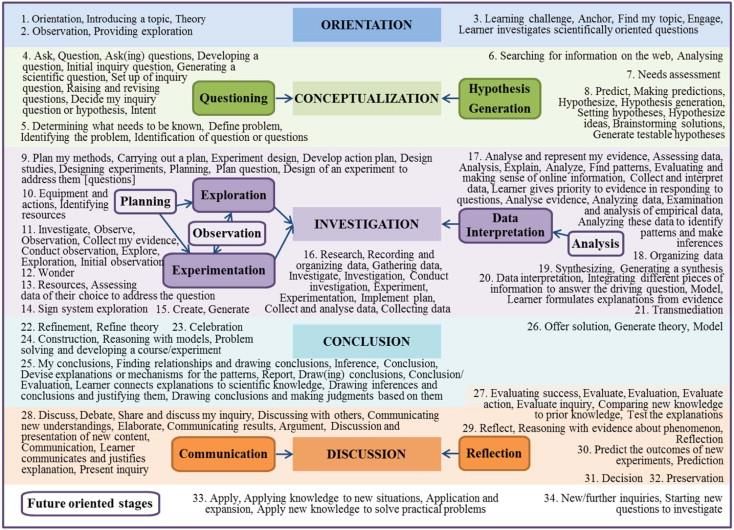
use various terminologies to label phases that are very similar. These authors summarize the Inquiry
Based Learning phases from different frameworks into 5 phases: Orientation, Conceptualization,
Investigation, Conclusion and Discussion (figure below).
Scheme of the five phases of the summarized model described by Pedaste et al. (2015).5.2 The five phases of Pedaste’s model in the Learning Unit
DAYLIGHTING RIVERS has developed Learning Units structured on the Pedaste model. The
choice of this model has different motivations: as it is an integration of other models, it is flexible and
adaptable to different kinds of Learning Units – such as simple explorative experiments in which different
variables are tested, or more complex scientific research studies. Understanding how Pedaste’s model
works is crucial, and therefore a description of each phase (adapted from Pedaste et al. 2015), together
with an example as guidance for the Learning Units, is reported here below. The following figure
20
summarizes the model as a cycle, because it is intended to lead to further investigations.
Phases of the learning Pedastes’s model within the Learning Unit.
At the beginning, the teacher introduces the DAYLIGHTING RIVERS project to the class by saying a
few words about the innovative and interdisciplinary learning path regarding the local rivers, with
reference to a relevant macro-theme of actual interest.
Then, a Learning Unit on a specific topic or river aspect is begun, with its activities following the
model of implementation described below. Here we give a general description of each phase
(objective and description) with some practical examples of questions and implementation activities.
Orientation
Orientation is the phase in which the interest and curiosity is stimulated in relation to the
problem or the topic. The teacher, as facilitator of the learning process, introduces the topic to the class.
In some situations or environments, the students define the topic by their curiosity (Scanlon et al. 2011).
The variables connected to the topic are identified during this phase and the problem statement is the
main outcome.
Objective: Presentation of the topic; identification of the problem and the variables
For instance, the teacher in the classroom shows some pictures of the selected river/area/canal.Do you know where this picture (river) has been taken?
What are the predominant characteristics?
Why is it like that?
Are there issues connected to this river?
21
Depending on the answers, the next phase identifies the questions and the hypothesis to investigate.
The learning units available are examples of activities that have been performed and implemented by
the piloting classes.
Conceptualization
Conceptualization is a process of understanding a concept (or concepts) belonging to the stated
problem. It is divided into two sub-phases, Questioning and Hypothesis Generation. These sub-phases
yield similar yet distinguishable outcomes: Questioning arrives at a research question or more open
questions about a domain, while Hypothesis Generation arrives at a testable hypothesis. Both of these
are based on theoretical justification and contain independent and dependent variables, but have one
key difference – the hypothesized direction of the relation between variables given in the hypothesis is
not present in the case of a research question (Mäeots et al., 2008). In general, hypothesizing is a
formulation of a statement or a set of statements (de Jong, 2006), while questioning is a formulation
of investigable questions (White & Frederiksen, 1998). Thus, the outcomes of the Conceptualization
phase are research questions or hypotheses to be investigated, or both if first research questions are
formulated and then hypotheses are generated based on these.
Objective: Identification of the questions and the hypothesis on specific topic/issues
The students should start reasoning about the aspects that they are curious to investigate, by posing
questions and formulating hypotheses.
Why does it look like that?
How does it work?
Where/when may it be different?
“Where does the (river) come from?
Where does it go?
How was it in the past, and how might it be in the future?
What is the colour of the water? Why?
How many animal and plant species live here?
What kind of sediments do we observe?
What differences may we observe compared to other locations?”
The project or the implementation of the investigation should involve more than one school
subject. Interdisciplinary activities integrate different approaches, methods of investigations allowing a
more comprehensive and coherent learning of complex issues. Knowledge on fauna and flora can be
acquired in the biology course, the quality of water and soil can be analysed in the chemistry course,
etc. Therefore, a good coordination between different teachers is expected in order to find and gatherthe needed data and information, as well as to attain a final synthesis that integrates the different
perspectives.
Investigation
Pedaste et al. write that investigation is the phase where curiosity is turned into action in order
to respond to the stated research questions or hypotheses (Scanlon et al. 2011), and they identify the
22 sub-phases of Exploration, Experimentation, and Data Interpretation.
Objective: planning, experimenting, analysing data and interpreting the results
Let’s do it!
1. Planning the investigation: list of materials and methods
2. Performing the investigation (experimenting) by gathering data and making
observations
3. Interpreting the results
During the preliminary activity of Planning, the students can actually design their investigation,
as this is also an important part of the work.
Planning the experimentation:
The teacher and the students plan their investigation, by deciding:
• Where to conduct the investigation
• What to do and how to do it
For instance, the preliminary work can be based on a map or an aerial photo (e.g. Google Earth),
using an interactive whiteboard. Students can identify the route of the (river) digitally or on the map,
observing where it starts, where it goes and how the territory is used (i.e. the land cover) along the
watercourse. They can measure the length of specific features and identify the location(s) where they
want to carry out the investigation. They also decide What and How to carry out the investigation (the
school’s subjects and topics are indicated in the Learning Units). For any kind of investigation (for
instance, analysing the river ecosystem by noting the species of plants, fishes, reptiles, and birds that
live next to a water course or taking water samples to test the water quality etc.), they will have to list
the materials and methods which they will apply, with the support of teachers and experts. Involving
experts from local research centres and universities can be a valuable opportunity to access up-to-date
knowledge and to make use of scientific equipment.
The Learning Units developed in DAYLIGHTING RIVERS cover several specific topics dealing with
water and land management. They include digital media, bibliographical references and worksheets for
teachers and students. Although some of them are developed for specific locations or issues, they serve
as examples for implementation in different contexts, adapted by the teacher to the local environment.
The Learning Units are available on the DAYLIGHTING RIVERS website
http://www.daylightingrivers.com/.
Acquired skills: photo-interpretation, map orientation, use of the scale, designing an investigation.
Performing the investigation
The investigation is the implementation of the previously devised plan, and thus follows from the
previous step along the project timeline.You can also read