Liquefaction - Frequently asked questions - Nelson City Council
←
→
Page content transcription
If your browser does not render page correctly, please read the page content below
Liquefaction - Frequently asked questions
http://www.nelson.govt.nz/environment/nelson-plan/natural-hazards/liquefaction/

1. What is liquefaction?
    Liquefaction refers to a process that can occur during earthquakes
    where ground shaking causes loose and saturated soil to loose strength
    and behave like a fluid.
2. In what situations could liquefaction occur?
    The key elements that are needed for liquefaction to occur are:
    •   Sufficient ground shaking during an earthquake (a combination of
        duration and intensity of shaking)
    •   Loose, non-plastic soil (typically sands and silts, and in some cases
        gravel)
    •   Saturated soil (ie below the groundwater table)
    Areas susceptible to liquefaction generally correspond with geologically
    young deposits (
Emergency Management Act. Managing these risks requires assessment
of the natural hazards, and identification of areas where they may
occur.
Managing natural hazard risks ensures that development occurs in
appropriate locations, and in ways that avoid or mitigate the risk. The
first step in managing the risk posed by a natural hazard risk is
assessing areas, or the entire region, to identify where the hazard may
occur (which involves mapping).
The latest liquefaction mapping was comissioned in response to updates
to the Building Code in 2019 requiring local authorities to complete
mapping of liquefaction hazard areas in their region by 29 November
2021. The Building Code updates were made to ensure that new
buildings are built safe and strong enough to withstand liquefaction
effects and came into force because of the experience of the Canterbury
earthquakes and subsequent recommendations made by the Royal
Commission of Inquiry.
5. What information is used to map the liquefaction hazard areas?
Regional liquefaction maps are based on technical assessments
undertaken by engineering geolgoists and geotechnical engineers. These
assessments consider information on the subsurface soils available from
regional and local geologic maps, along with ground surface elevations,
aerial imagery, and regional seismicty to identify areas that may contain
susceptible saturated deposits. More detailed assessments involve
quantitiative liquefaction assessessments that identify the range of
liquefaction damage predicted for a site during a specific earthquake
event. These assessments are typically applied at a local scale and
consider the specific subsurface soil types at the site as identified from
geotechnical investigations, along with estimated earthquake shaking
for a design event, and measured groundwater levels.
The latest regional liquefaction mapping is based on an assessment by
Beca which follows the methodology set out in in the joint Earthquake
Comission (EQC)/ Ministry of Business, Innovation and Employment
(MBIE)/Ministry for the Environment (MfE) guidance. You can view this
guidance document at: building.govt.nz/assets/Uploads/building-code-
compliance/b-stability/b1-structure/planning-engineering-
liquefaction.pdf
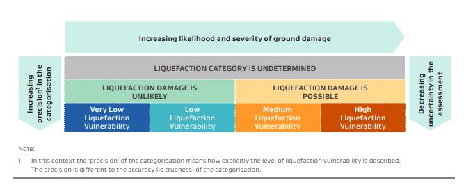
6. What do the liquefaction maps show?
The liquefaction map identifies areas where liquefaction damage is
possible in the event of strong shaking from an earthquake. These
correspond with areas identified as potentially containing loose and
saturated deposits that are susceptible to liquefaction.
FAQs – Liquefaction hazard –May 2022
Page 2The mapping is colour coded acording to liquefaction vulnerability
catergories assigned in the MBIE guidenance document. The yellow/gold
colour indicates where liquefaction damage is possible. The green colour
shows where liquefaction damage is unlikely.
7. Why is my property included in the liquefaction susceptibility
area when it has never been affected?
Councils are required to look at risk over a long time period to help
inform decisions regarding future development and land uses. During
our lifetimes, Nelson has not experienced an earthquake of the
magnitude that would cause liquefaction damage, like Christchurch did.
8. Will this information go on my property file and Land
Information Memorandum (LIM)?
Yes. All property files have been updated with this natural hazard
information and a new LIM notation has been included.
Under the Local Government Official Information and Meetings Act 1987
Council has an obligation to provide LIM notations regarding information
it holds on natural hazards (including liquefaction) but is not yet
contained within the local District Plan.
Even in circumstances where the liquefaction hazard is only identified on
a small portion of a property (e.g. driveway or garden), Council is still
required to note this on the LIM and property information file.
9. What does the LIM notation say?
Liquefaction hazard
The Council holds a report (Nelson Regional Liquefaction Assessment,
23 November 2021) that identifies this property, or part of this
property, as ‘liquefaction damage is possible’ meaning it is potentially
susceptible to ground damage caused by liquefaction during
earthquakes.
The data contained within the Nelson Regional Liquefaction
Assessment report has been generated at a regional scale (1:25,000)
FAQs – Liquefaction hazard –May 2022
Page 3using regional datasets. Site specific liquefaction assessments were not
considered. The assessment is indicative of the potential for
liquefaction to affect any individual site or property. To determine the
specific liquefaction hazard affecting any individual site or property, a
site-specific assessment may need to be undertaken.
Further refinements to the geographic extent of the identified area
where ‘liquefaction damage is possible’ may occur in the future, for
example as the Nelson Resource Management Plan (NRMP) is updated.
As a result, the liquefaction information recorded on the LIM for this
property may be updated in the future.
A copy of the Nelson Regional Liquefaction Assessment report, and
previous reports on liquefaction hazard, can be accessed online at
http://www.nelson.govt.nz/environment/nelson-plan/natural-hazards/
or by contacting the Planning Administrator on 5460200.
10. My property in Tāhunanui was developed using appropriate
foundation treatment to mitigate the risk of liquefaction. Why
do I still have a LIM notation on my property file?
Since 2013, a number of new developments in Tāhunanui have
incorporated appropriate foundation treatments into the building
design to mitigate the risk of damage from liquefaction. While this may
have mitigated the risk of liquefaction damage to the building, other
parts of the property could remain at risk e.g. driveways and gardens.
On this basis, it is appropriate that a LIM notation remains on the
property file to ensure that liquefaction is considered when assessing
any future development proposals on the site and to inform potential
buyers.
11. Why has my property in Eastern Tahunanui now been identified
as susceptible to liquefaction when previous assessments
found that it wasn’t?
Our understanding of liquefaction in Nelson continues to evolve as new
areas are assessed and we undertake more detailed studies in areas
we are already aware of.
Methodologies for assessing liquefaction also change over time. The
recent region-wide assessment of liquefaction used the methodology
outlined in national guidance issued by the Ministry of Business,
Innovation and Employment (MBIE) in 2017 for planning and building
on liquefaction-prone land. This is a different methodology to the one
used for previous assessments of Tahnuanui undertaken in 2013 and
2014. The setting of the Tahunanui area indicates it is underlain by
geologically young, loose, and saturated deposits meaning the
susceptiblitly of these deposits cannot be discounted.
12. Can I get the LIM notation removed?
FAQs – Liquefaction hazard –May 2022
Page 4Under section 44A (2) (i) and (ii) of the Local Government Official
Information Management Act (LGOIMA) councils are legally obliged to
include this information on LIMS if it is not apparent from the District
Plan (in Nelson’s case, the NRMP). However, once this information is
included in an operative District Plan, the LIM notation may be
removed.
13. Will being in the liquefaction area limit the ability to build a
new house or extend an existing one on my property?
Anyone looking to carry out building or development on their land need
to ensure that they gain the appropriate building and/or resource
consent.
There are currently no rules in the NRMP regarding development in an
area at risk from liquefaction hazard specifically. However liquefaction
can be considered in some resource consent processes where natural
hazards need to be considered more broadly.
In the future, areas of Nelson that may be susceptible to liquefaction
are expected to be included into the NRMP, or into a new resource
management plan.
If you require a building consent, the Council’s assessment would
consider liquefaction. It would consider the proposed location and type
of foundations, the purpose of the building, and the risk to people,
property, infrastructure and the environment from liquefaction. Please
visit the Council’s building consent webpage for more information
regarding new buildings in areas of liquefaction:
nelson.govt.nz/new-buildings-and-liquefaction-effects
14. Can my property still be subdivided if it’s in the liquefaction
suscpeibility area?
Subdivision requires resource consent. The rules for subdivision are
contained in the Nelson Resource Management Plan. Natural hazards
are taken into account when considering an application to subdivide
land within areas susceptible to natural hazards, including liquefaction.
15. What if I want to sell my property?
Any potential buyer can access the relevant land and property
information files in relation to natural hazards. To find out more about
requesting property files and fees involved (there is no fee if you are
the property owner) please visit: nelson.govt.nz/requesting-property-
files
Prospective buyers can also purchase a LIM from the Council. To find
out more about obtaining a LIM and the fees involved, please visit:
nelson.govt.nz/land-information-memorandum-lim-reports
16. Will this information affect my property value or insurance?
FAQs – Liquefaction hazard –May 2022
Page 5Council cannot advise property owners about any effect this
information may have on your property values or insurance. We
recommend property owners seek professional advice from a property
valuation or insurance expert about any concerns you may have
regarding these matters.
17. Will I be covered by the Earthquake Commission (ECQ) if my
property is affected by an earthquake?
EQC cover provides natural disaster insurance for residential homes
and some areas of residential land after earthquakes, landslips,
volcanoes, tsunami and hydrothermal activity. It also provides cover
for storm flood damaged land.
For more information, please refer to EQC’s website:
eqc.govt.nz/what-we-do/what-youre-covered-for
18. Where do I find information about what to do during an
earthquake?
Civil defence information and advice on getting prepared can be found
on the Nelson Tasman Civil Defence Emergency
Management website.
FAQs – Liquefaction hazard –May 2022
Page 6You can also read