LIVING BREAKWATERS: A MULTI-LAYERED APPROACH TO COASTAL ADAPTATION - Adaptation Canada
←
→
Page content transcription
If your browser does not render page correctly, please read the page content below
LIVING BREAKWATERS: A MULTI-LAYERED
 APPROACH TO COASTAL ADAPTATION

 Adaptation Canada
 Vancouver, February 19-21, 2020
Hewitt haikudeck.com

 Kees Lokman (klokman@sala.ubc.ca)
 Assistant Professor, UBC
OUTLINE
➤ Project Overview
➤ Coastal Adaptation Platform
 ✦ Interactive map browser
 ✦ Time-based narratives
 ✦ Adaptation strategies
➤ Point Grey Cliffs
 ✦ Modeling marine conditions
 ✦ Plant geography & potential for
 slope stabilization
 ✦ Social, economic, legislative, &
 environmental assessment

 2
OUTLINE
 ➤ Project Overview
 ➤ Coastal Adaptation Platform
 ✦ Interactive map browser
 ✦ Time-based narratives
 ✦ Adaptation strategies
 ➤ Point Grey Cliffs
 ✦ Modeling marine conditions
 ✦ Plant geography & potential for
 slope stabilization
 ✦ Social, economic, legislative, &
 environmental assessment

 3
THE LIVING BREAKWATERS PROJECT

➤ Funded by Natural Resources Canada
 (May 2018 - December 2020)
➤ 2 overarching objectives
 ✦ to advance the adaptation knowledge in
 the region and beyond, and
 Hawke

 ✦ to develop solutions for erosion of the
 Point Grey cliffs.

 Boyes

 4
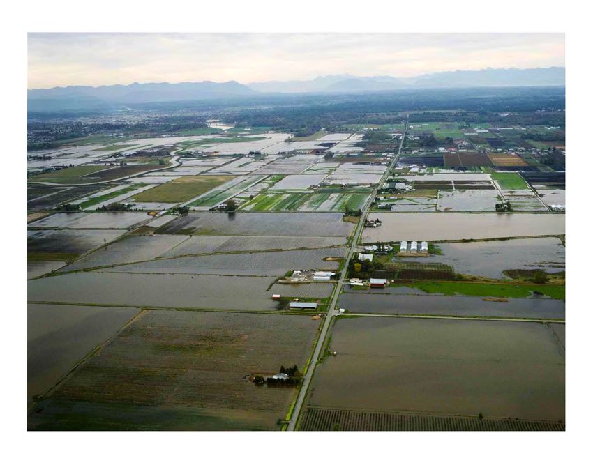
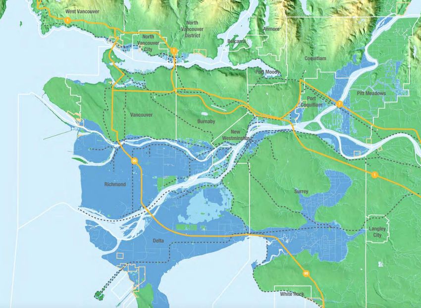
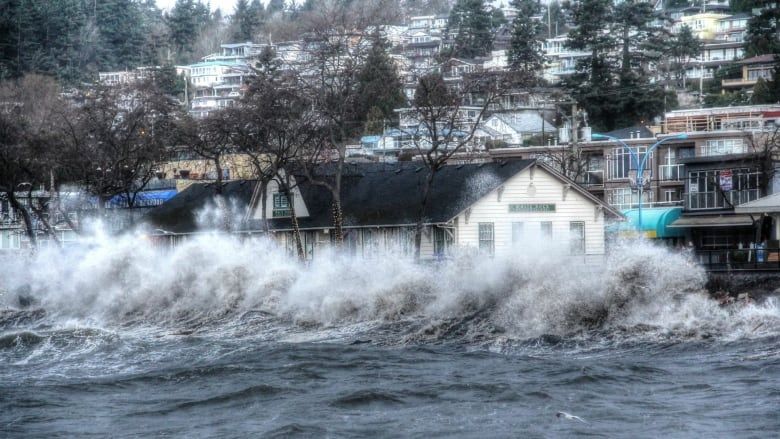
Coastal Risks in
The Fraser Delta

 5
102
Species at Risk
 of Extinction

 6
Impact
Livelihood 11 FN
 Communities
 (in Metro Vancouver)

 7
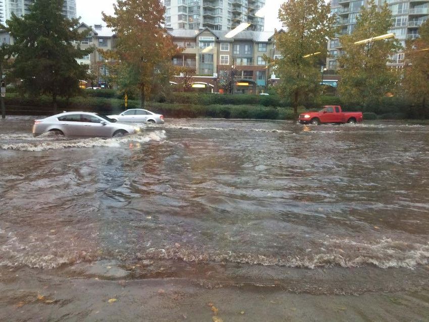
>238,000 people
directly impacted
 (based on present day flood event)

 Source: Fraser Basin Council

 8
Agricultural
losses ~$690M
(based on short-duration present day flood event)

 Source: Fraser Basin Council

 9
Economic
losses ~$20-23B
 (based on present day flood event)

 Source: Fraser Basin Council

 10
Multifaceted
 Issue
•Flood Control
•Land Use Planning
•Urban Design
•Emergency Management
•Spatial Justice
•Subsidence
•Salinization
•Coastal Habitat Squeeze
•Insurance
•Governance
•Real Estate Development
•Geotechnical Engineering
•Infrastructure Systems
 11
OUTLINE
 ➤ Project Overview
 ➤ Coastal Adaptation Platform
 ✦ Interactive map browser
 ✦ Time-based narratives
 ✦ Adaptation strategies
 ➤ Point Grey Cliffs
 ✦ Modeling marine conditions
 ✦ Plant geography & potential for
 slope stabilization
 ✦ Social, economic, legislative, &
 environmental assessment

 12
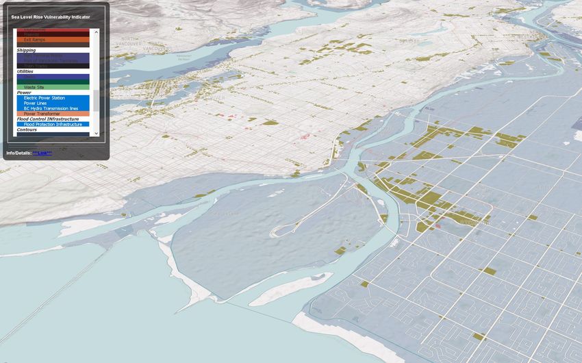
1. INTERACTIVE WEB BROWSER

 Highlights different flood scenarios

 Shows the areas under risk (flood plains,
 infrastructures, institutional buildings,
 impervious areas, etc.)

 Shows different vulnerability areas (social,
 built environment, ecological vulnerability)

 Provides an option to download data/maps

 13
14
1I. TIME-BASED NARRATIVES

 Provides detailed information on areas/
 timelines/progress or cascading impacts of
 a selected issue

 Graphically rich, preferably dynamic
 presentation

 5-8 narratives total (utilities/
 infrastructure, ecosystem health,
 agriculture, urban development, cultural/
 heritage)
 15
16
17
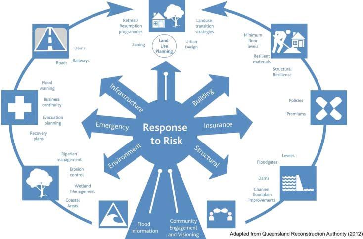
1II. ADAPTATION STRATEGIES

 ~25 different
 strategies with
 embedded with links
 and information on
 costs, permitting,
 case studies. etc.
19
20
21
OUTLINE
➤ Project Overview
➤ Coastal Adaptation Platform
 ✦ Interactive map browser
 ✦ Time-based narratives
 ✦ Adaptation strategies
➤ Point Grey Cliffs
 ✦ Modeling marine conditions
 ✦ Plant geography & potential for
 slope stabilization
 ✦ Social, economic, legislative &
 environmental assessment
 ✦ Understanding Values 22
UNDERSTANDING FACTORS CAUSING CLIFF EROSION
 extreme
 rainfall

 cultural landscapes
 places of learning
 ceremonial sites

 infrastructure
 & assets stormwater
 runoff

 cliff
 recession

 sea level rise + storm surge
 seepage
 wind+wave runup tide level
 beach mean sea-level
 erosion
 23
A MULTI-LAYERED APPROACH TO COASTAL ADAPTATION

 PAST PRESENT FUTURE

 Literature review Modeling marine Stakeholder
 conditions engagement

 Historical events and Plant geography Adaptation strategies
 coastal interventions
 Social, economic, Potential
 legislative, implementation
 environmental strategies
 assessment

 Understanding place

 24
A MULTI-LAYERED APPROACH TO COASTAL ADAPTATION

 PAST PRESENT FUTURE

 Literature review Modeling marine Stakeholder
 conditions engagement

 Historical events Plant geography Adaptation strategies
 and coastal
 interventions Social, economic, Potential
 legislative, implementation
 environmental strategies
 assessment

 Understanding place

 25
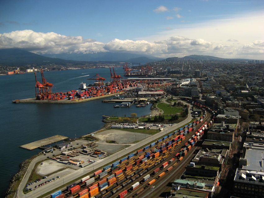
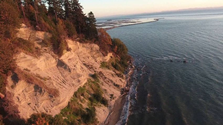
POINT GREY CLIFFS
 Point Grey
 Cliffs

 MOA

 University of
 British Columbia

 Wreck Beach

 Pacific Spirit
 Park

 • Musqueam First Nation
 • 5 jurisdictions
 •19 different stakeholders
 Pacific Spirit Society

 26
e of soft sediment material with mean diameters of the sediments in the cliff ranging from 200 to 300 µ
au Associates, 2002). The cliff tops are about 50 to 80 meters above mean sea-level (Piteau Associat
, Pool, 1975). POINT GREY CLIFFS

 Piteau Associates (2002)

 Figure 1.6: Typical composition of Grey Point coastal cliffs. From Piteau Associates (2002). 27
POINT GREY CLIFFS

c.1925 c.1950
 UBC
 construction

 clear cutting
 UBC library & erosion UBC library

 28
2 APPROACHES (NATURAL)

1975 1976

 UBC library

 UBC library UBC library

 29
2 APPROACHES (ENGINEERED)

 1981

 UBC library

 UBC library UBC library

 30
POINT GREY CLIFFS

1983 2013
 MOA

 UBC library CTV News

 Gravel Replanting Berms
 Landslides
 31
A MULTI-LAYERED APPROACH TO COASTAL ADAPTATION

 PAST PRESENT FUTURE

 Literature review Modeling marine Stakeholder
 conditions engagement

 Historical events and Plant geography Adaptation strategies
 coastal interventions
 Social, economic, Potential
 legislative, implementation
 environmental strategies
 assessment

 Understanding
 place

 32
I. MODELING MARINE CONDITIONS Scenarios
 ➤ Tidal characteristics
This chapter uses the conditions presented in Chapter 3 to generate test scenarios for the hydrodynamic
 ➤ Wind
model. & waves
 The first section describes the steps to these primary scenarios. In the second section the other base-
and sensitivity cases are presented.
 ➤ Storm surges
5.1. Test scenarios
 ➤ Fraser
In this section theRiver
 setup of the scenarios is discussed. The main dividing factors are whether waves are in-
cluded in the model and which discharge of the Fraser River, either freshet or non-freshet. At the end of this
 ➤ Human
section the resultingInterventions
 scenarios are shown.(marine worksin&
 All cases presented dredging)
 Table 5.1 have bottom sediment available
with a D 50 of 380 µm.
 ➤ Conceptual sediment budgets
 Table 5.1: Proposed present-time model scenarios.

 Scenario ID Period Tidal range River discharge Wind/waves
 1 Aug. - Apr. Normal Non-freshet WNW
 2 Aug. - Apr. Normal Non-freshet ESE
 3 Aug. - Apr. Normal Non-freshet Eastern storm (5 years RP)
 4 May - Jul. Normal Freshet Western storm (5 years RP)
 5 May - Jul. Normal Freshet WNW
 6 May - Jul. Normal Freshet ESE

 Rens Harteveld 34
4.4. Bathymetry 30

 4.4. Bathymetry
 The depths of the different grids are from a variety of sources. The depths in the large model (Fig. 4.4a) is

 I. MODELING MARINE CONDITIONS
 from the NOAA with partly additions from the Delft Dashboard GEBCO-08 satellite database. The depths
 in the intermediate model are again partly from the NOAA depth samples, but also more detailed additions
 of nautical charts of Point Grey and the Fraser Main Arm (see Appendix D) are implemented. Both these
 admiralty charts are shown below in Fig. D.1 & D.2.

 3
computational
 grids

 (a) Depth large grid.
 (b) Depth intermediate grid.

 Close-up of
 the finest grid

 (c) Depth fine grid. (d) Fine model depth zoomed in. Rens Harteveld 35
I. MODELING MARINE CONDITIONS
 (a) Significant wave heights of scenario 8a at low water.

6.2. Waves 48

 Causes of marine erosion
 ➤ Direct wave attack &
 wave run-up during high
 tide and storm events

 (a) Significant wave heights of scenario 8a at low water. (b) Significant wave heights of scenario 8a at high water.
 ➤ Long shore sediment
 Figure 6.8: Difference in significant wave heights during high and low waters of scenario 8a.
 transport by tides and
 waves.
 ➤ Deficit of sediment input
 to the coastal system.
 ➤ Sea level rise
 (b) Significant wave heights of scenario 8a at high water.

 Figure 6.8: Difference in significant wave heights during high and low waters of scenario 8a.

 Rens Harteveld
 Rens Harteveld 36
PLANT GEOGRAPHY AND POTENTIAL FOR SLOPE STABILIZATION
➤ Density and types of the plant understory and canopy
 impacting Cliff ’s surface erosion.

 Shaun Yap, Amanda Eliora, Dr. Nina Hewitt 33
II. PLANT GEOGRAPHY + POTENTIAL FOR SLOPE STABILIZATION
Candidates to stabilize the soil
along the cliffs
➤ Big-Leaf Maple and Red Alder for
 canopy
➤ Sword Fern and native Rubus species
 (Trailing Blackberry) for understory
Other findings
➤ Western Red Hemlock, Douglas Fir and
 Western Red Cedar show relatively
 low abundance, indicating they
 either failed to establish or failed
 to reproduce

 Shaun Yap, Amanda Eliora, Dr. Nina Hewitt 37
III. SOCIAL, ECONOMIC, LEGISLATIVE & ENVIRONMENTAL ASSESSMENT

 TECHNICAL

 SOCIAL ENVIRONMENTAL

 LEGISLATIVE ECONOMICAL

 38
III. SOCIAL, ECONOMIC, LEGISLATIVE & ENVIRONMENTAL ASSESSMENT

 Musqueam FN
 TECHNICAL
 Port of Vancouver
 DFO
 Province of BC
 Metro Vancouver
 City of Vancouver SOCIAL ENVIRONMENTAL

 UBC Campus
 Planning
 Univ. Endowment L.
 Private owners
 Pacific Spirit Park
 UBC community
 Tourists LEGISLATIVE ECONOMICAL

 7 NGOs

 39
III. SOCIAL, ECONOMIC, LEGISLATIVE & ENVIRONMENTAL ASSESSMENT
 Fisheries Act
 Species at Risk Act
 TECHNICAL
 Navigable Waters Act
 Environmental Protection Act
 Migratory Birds Convection
 Act
 Canada Marine Act
 SOCIAL ENVIRONMENTAL
 Land Act
 Wildlife act
 Guidelines for Management
 of Coastal Flood Hazard
 Sea Dike Guidelines 2010
 Riparian Rights and Public
 Foreshore Use
 Land Use, Building and
 Community LEGISLATIVE ECONOMICAL
 Official Community Plan
 Land Use 2015

 40
water bodies.
 etention facilities can be installed above ground in the form of ponds or swales or placed
 underground. As the ground at B is costly, limited and above ground structures require a
 lot of surface area, an underground vault is installed. The stormwater is temporarily stored
 in the vaults and is released at a much lower rate to reduce the erosive force of the water.
 Besides, suspended solids and floating pollutants as oil are removed from the stormwater in

III. SOCIAL, ECONOMIC, LEGISLATIVE & ENVIRONMENTAL ASSESSMENT
 the vault.

 8.1. Technical
 TechnicalFeasibility
 easibilit
 The vault consist of an inlet pipe, a detention chamber with baffles, an outlet pipe and a
 49

 manhole,
 Tablesee Figure
 8.2: 10.2.
 Run-up The needed
 calculations storage
 for the volumebeach,
 engineered of the using
 chamber is predicted
 the wave to beslope at x=30 m
 height and
 2,600 by B s 100 year-storm model [54]. However, since this model was created new

 Do nothing
 water management measures have been taken and it is therefore advised to create a new
 Number
 100 year-storm Water Hm0 the Tp
 model to determine L0of theSlope
 dimensions pipes and Run-up
 the chamber.Reduction
 To have with respect
 sedimentation of suspended solids in the vault, it is recommended that the chamber has a
 Scenario level [m] [m] [s] [s] [-]
 length-to-width ratio of at least 1:4 and preferable of 1:6 [24].
 [m] to original scenario [%]
 1 2.4 0.83 7.20 80.97 0.03 0.84 64%

 Subaerial
 2 3.4 1.43 7.20 80.97 0.03 0.70 69%
 3 3.5 1.52 7.20 80.97 0.03 0.68 69%

 1.Revegetation
 As it can be observed from the calculations, the run-up is considerably reduced by the
 new beach profile, mainly due to its wave attenuation effect.

 Floating Wetlands. Floating Islands have proven to be successful for wave energy at-

 2.Stormwater detention facility tenuation, protecting bank and shoreline from wave erosion. According to AquaBio [60] the
 reduction in deep water is around 80 % and in shallow water between 58-90%, depending
 on the width and thickness of the island. These results refer to a controlled experiment at
 Alden Laboratories, with waves between 18-25 cm [60].

 3.Inter-aquifer drainage wells This technology aims to imitate the natural floating wetlands, and it consists of three basic
 elements: a base, an anchor and plant material. An example can be seen in Figure 8.4.
 Figure 10.2: nderground storm vault with inlet pipe, outlet pipe, manhole and detention chamber. d usted by authors from
 [57].

 Marine The detention facility is installed underneath a parking area as this can easily be made
 into a construction site and parking areas are, next to roads, a big source for stormwater
 pollution [56]. In Figure 10.4 the parking lots in the pro ect area are given. Additionally, it is
 important that the vault is installed in an area where floodings are expected in a 100 year-

 1.Rip-rap and rock revetment
 storm event, to minimi e the runoff before the water enters the vault. Areas where significant
 surface flooding is predicted are shown in Figure 10.3 [54]. When comparing Figure 10.4 with
 Figure 10.3 parking lots are found in Area 2. This area is therefore thought to be the most
 efficient area for installing the detention vault. Additionally, it is advised to install pipes in
 the high risk flooding areas which lead the water to the inlet pipe of the detention vault.

 2.Engineered beach & floating wetlands
 3.Clam gardens

 Irene Cantoni,
 Figure 8.4: Floating Wetlands components [38]. Camilla Gaido, Tessa Jonker, Laura van Gijzen 41
III. SOCIAL, ECONOMIC, LEGISLATIVE & ENVIRONMENTAL ASSESSMENT
 Table 12.1: oncepts summary. ource: authors.

 oncept Technical nvironmental conomical Legislative Social
 - abitat will disappear as the
 - on intervention - ost of campus land - ommunity affected
 cliff erodes - Without intervention no
 o Nothing - rosion will continue - ost of infrastructure: by the lost of land and
 - robably new habitats will permission is needed
 as business as usual buildings, roads and sewer cultural heritage
 be formed
 - Reduction of the available
 - ffective protection habitat
 - inimum maintenance - eeds to meet the urisdictional - hange of the aesthetic landscape
 Rip-rap of the toe - t is recommendable carrying
 - Total estimated cost is demands of , and - each may be not suitable
 and roc revetment - oes not solve the problem the most nuisance activities
 around 210 anada s government for pedestrians
 of sediment budget during winter reduce the
 loss of species
 - lteration of the habitat due
 - t copes with problems of to coverage of new type sand
 - aintenance of floating wetlands
 marine erosion and and increase of turbidity -Federal, provincial and
 ngineered and beach must be considered - hange of the aesthetic landscape
 sediment budget - Floating islands give a new habitat local urisdictional
beach and loating wetlands - Total estimated cost is - ncrease of available recreational beach
 - ac of studies to ensure but can generate a dead one behind demands must be fulfilled
 around 180
 level of effectiveness -Resilient solution that can be
 adaptable to R
 - lteration of habitat from
 beach to clam garden
 - ow water uality can impact in - aintenance of clam
 - oes not solve the problem
 clamps contamination not suitable gardens must be - rovincial and local
 lam gardens and of sediment budget - hange of the aesthetic landscape
 for human consumption considered urisdictional demands
 submerged brea water - ac of studies to ensure -First ations cultural heritage
 - ncrease of habitat for clams - Total estimated cost is must be fulfilled
 level of effectiveness
 and other species around 35
 -Resilient solution that can be
 adaptable to R
 - Revegetation provides new
 - liff stability is aim through
 habitats expanding the existing
 revegetation. fficiency is not certain - The three approaches are in
 wildlife population -Revegetation adds aesthetic value
 - igh speed flow over the cliff is - aintenance vegetation land thus must be
 - The stormwater detention removes - torm water facility reduces
 avoid through an underground must be considered approved mainly by
 Subaerial contaminants improving water nuisances due to flooding
 stormwater detention facility - Total estimated cost is - torm water detention facility
 uality - Revegetation and drainage wells
 - nter-a uifer drainage wells reduce around 7.5 and drainage wells plans must
 - The drainage wells can influence the increase safety for cliff s visitors
 thus seepage erosion. est location follow guidelines
 uality and uantity of ground water
 is difficult to be determined
 i.e oxidation of dissolved metals

 Irene Cantoni, Camilla Gaido, Tessa Jonker, Laura van Gijzen 42
III. SOCIAL, ECONOMIC, LEGISLATIVE & ENVIRONMENTAL ASSESSMENT
 Comparison suggests
 ➤ Hard marine approaches
 ✦ work well to stop the waves
 ✦ do not solve the sediment deficit problems
 ✦ Negative economic and environmental impacts
 ➤ Soft/hybrid approaches
 ✦ high uncertainty as there is no precedent in this region
 ✦ supply more sediment
 ✦ have more environmental, social and economic benefits
 ✦ possible regulatory complications
 ➤ Access to cliff presents practical challenges
 Irene Cantoni, Camilla Gaido, Tessa Jonker, Laura van Gijzen 43
NEXT STEPS — UNDERSTANDING VALUES AND PERSPECTIVES

 44
FINAL REMARKS
➤ Provide an online platform that advances
 adaptation knowledge in the region and
 beyond
➤ Provide information on adaptation strategies
 and adaptation resources
➤ Case study to examine different factors
 contributing to erosion Hawke

➤ Identify tangible & intangible assets at risk
➤ Bring people together to discuss different
 values and perspectives on adaptation
➤ Lead to more informed, involved & Boyes

 meaningful decisions (hopefully) 45
 45
THANK YOU / QUESTIONS ?

 Kees Lokman
Assistant Professor of Landscape Architecture
 University of British Columbia
 klokman@sala.ubc.ca

 46
You can also read