Locational Impact of Petrol Filling Stations Close to Residential Buildings in Ife Central, Nigeria
←
→
Page content transcription
If your browser does not render page correctly, please read the page content below
SSRG International Journal of Humanities and Social Science Volume 8 Issue 2, 29-36, Mar-April, 2021
ISSN: 2394 – 2703 /doi:10.14445/23942703/IJHSS-V8I2P106 © 2021 Seventh Sense Research Group®

 Locational Impact of Petrol Filling Stations Close
 to Residential Buildings in Ife Central, Nigeria
 M.A. Oyinloye1*, O.E. Abiola2
 1
 Dept. of Urban and Regional Planning, Federal University of Technology, Akure, Nigeria
 2
 Dept. of Urban and Regional Planning, Federal University of Technology, Akure, Nigeria

 Received Date: 18 February 2021
 Revised Date: 21 March 2021
 Accepted Date: 04 April 2021

Abstract - The emergence and indiscriminate siting of fuel vehicle owners (Iman, Ismail, & Martin, 2009). However,
petrol stations all across the country call for urgent in recent times, there had been a proliferation of filling
investigation of the impact of their sitting at close stations sited across different parts of the country with
proximity to residential areas and absurd places at Ife rising concerns for safety as a sizable number of them do
Central, Nigeria. This project was conducted to assess the not meet nor comply with the stipulated operational
locational impact of petrol filling stations (PFS) close to licenses requisite safety measures (fire standards, layout,
residential buildings in Ife Central, Nigeria. The spatial location, and waste management) by the regulatory bodies.
locational pattern of fuel stations was analyzed and its They were sited in close proximity to each other and in
resultant impact on Ife Central, Nigeria, to determine the residential areas contrary to the guidelines for siting such
degree of compliance of the PFS with planning standards accident-prone facilities. These practices, therefore, pose a
and regulations; and assess the physical, social and dangerous trend and heightened public health risk on the
economic relationship between the PFS and residential neighboring life, properties, and environment (Afolabi et
land uses in the study area. Fifty-two (52) were sampled al., 2011).
for data collection. A two-phase mixed-method approach Fuels are primarily hydrocarbons containing volatile
was adopted, using qualitative interviews to validate organic compounds such as benzene, some of which are
identified factors. Upon the validation of the location injurious and harmful if in contact with skin and as well
factors through an inductive approach, a quantitative posit low dosage upon exposure to it (Linet et al., 1996).
questionnaire was formulated. Using a quantitative The safety of lives and properties and protection of the
survey, data were collected from 340 respondents. The environment are therefore of major concerns revolving
data were then analyzed using factor analysis and around the petrol filling stations. At ambient temperature,
structural equation modeling to determine the factors and petrol and other vehicle fuels are potentially hazardous.
their relationship with factors of location. The analysis Petrol gives off vapour when mixed with air in appropriate
reveals cumulative non-compliance to principles and proportions. It burns with explosive force if ignited.
standards by all the PFS. The nearest neighbour ratio was Moreover, all petroleum products are potential pollutants,
0.56, showing the PFS distribution was cluster distribution which, if not properly handled or managed, can damage
pattern of the fuel stations, portraying an unorganized the environment - injurious to aquatic life and harmful to
distribution. This cluster distribution pattern impacts human health if inappropriately handled (Health and
negatively on the residents’ wellbeing, environment, and Safety Executive, 2018).
socio-economic life. The study also identified owner
preferential choice and planning standards; storage Petroleum is a dominant source of revenue and foreign
material and factor of location; environmental impact exchange in Nigeria. It strategically accounts for about
assessment; type of license; and distance between the 78% of Gross Domestic Product and up to 90% of the
tanks and site management and administration as the five country’s total annual revenue and foreign exchange
factors that directly influenced the choice of location of earnings (National Bureau of Statistics, 2008). The
the Petrol Filling Stations (PFS). petroleum industry in Nigeria is divided into two - the
 upstream and the downstream sectors. The upstream refers
Keywords: Petrol Station, Residential, Impact, Planning to activities such as exploration, production, and delivery
Standards. to an export terminal of crude oil or gas. The downstream,
 on the other hand, encompasses activities like loading
 I. INTRODUCTION crude oil at the terminal and its user, especially
 The relevance and importance of technological transportation, supply trading, refining distribution, and
advancement and man’s need for energy (man-made) marketing of petroleum (Asada, 2010). The public actors
generation are high and enormous. Fossil fuel is still are government agents and functionaries such as the
relevant in meeting the energy demand; its utilization in Nigerian National Petroleum Corporation (NNPC) and its
the automobile makes the strategic building of petrol subsidiaries, the Department of Petroleum Resources
filling stations (PFS) important to meet the demand of (DPR), the Petroleum Product Pricing Regulatory

 This is an open access article under the CC BY-NC-ND license (http://creativecommons.org/licenses/by-nc-nd/4.0/)
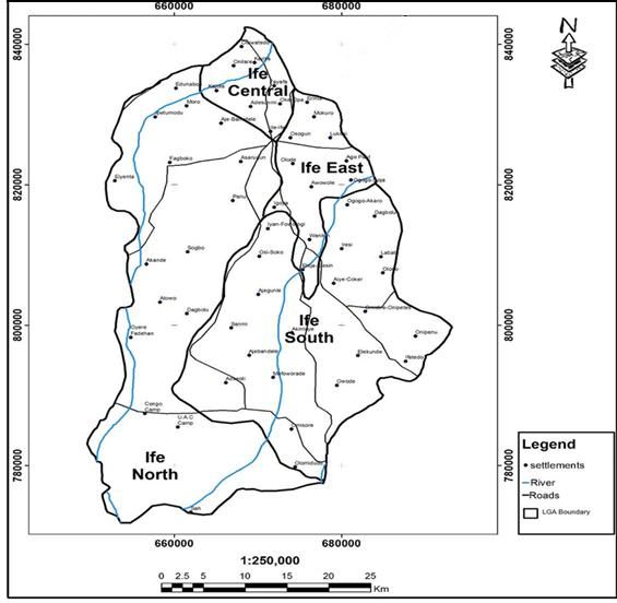
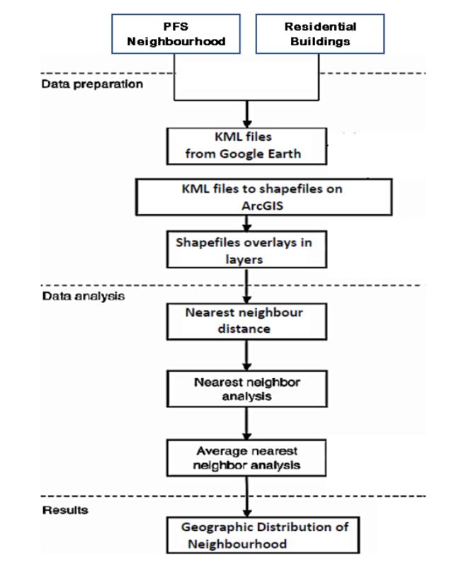
M.A. Oyinloye & O.E. Abiola / IJHSS, 8(2), 29-36, 2021

Authority (PPPRA), among others. The private segments III. MATERIALS AND METHODS
consist of both indigenous and foreign actors. The The following data were used in carrying out this research
indigenous actors consist of independents marketers, work: The primary source included the administration of
which numbered about 1000 in 1979, a year after structured and unstructured questionnaires, oral interview,
formulating the act which established them but increased personal observation, topographical map of Ile-Ife of 1966
to 7948 in 2010. They compete with the foreign or with the scale of 1:50,000 produced by the survey
multinational marketers like Mobil Oil Nigeria Plc., MRS department of the state, Geographic information system
Nigeria Plc., Total Nigeria Plc., and Africa Petroleum Plc. (GIS), Global Positioning System(GPS). Two different
Studies have reported that inhalation of benzene in the questionnaires were prepared; one for fuel station owners
environment caused mucous membrane irritation, heart or managers and the other for residents in the study area.
attack, cancers of the lung, brain, and stomach, leukaemia, There were fifty-two fuel stations covered or analyzed in
aplasia, dermatitis, and bone marrow depression the study area, and they were all enumerated to determine
(Sangotola, Fasanmade, Ayanrinde, Olatinwo, & Olaniran, their level of compliance with the guidelines set by the
2015) Department of Petroleum Resources. The second
 questionnaire was used to conduct a survey of residents’
 II. STUDY AREA opinion regarding the location of fuel stations and their
 The city of Ile-Ife (Figures 1.1-1.3) is the headquarter implications around them. The entire filling stations
of Ife Central Local Government Area of Osun State, located in the study area were altogether sampled. A
Nigeria. It is located on latitudes 7˚26' N and7˚32' N of the purposive sampling method was adopted to administer
equator and longitude 4˚29' E and 4˚37' E of the Meridian. questionnaires. This sampling technique represents a
The population of the area is about 167,254 persons group of non-probability sampling techniques; and a
consisting of 88,403 males and 78,801 females, based on judgmental or selective sampling of which the researcher
the 2006 census result (Nigeria Population Commission, relies on his whims and whims to select the respondent. A
2007). The vegetation in Ile-Ife is made of three canopy total of ten (10) respondents with close proximity to each
heights, the tallest trees up to 25m high with canopies far petrol station were randomly sampled, forming the sample
apart, the middle layer 10-15m high with rather size for residents living around the filling station. A total
discontinues and irregular canopy, and the third layer of three hundred and forty (340) questionnaires were
comprises of dense saplings and shrubs generally less than administered to get the necessary information for this
5m high. The vegetation in Ile-Ife is made of three canopy research. The Global Positioning System (GPS) was used
heights, the tallest trees up to 25m high with canopies far to pick the coordinates of the petrol stations in the study
apart, the middle layer 10-15m high with rather area, while the satellite imagery was used to randomly
discontinues and irregular canopy, and the third layer sample the number of buildings within 50 meters and 100
comprises of dense saplings and shrubs generally less than meters range to the petrol stations.
5m high. The floor is originally covered by a fairly thick
layer of the little forest.

 Fig.-1: Map of Ife showing Ife Central Local
 Government
 Fig.- 2: Nearest neighbourhood analysis
Source: Author’s Fieldwork (2018)

 30
M.A. Oyinloye & O.E. Abiola / IJHSS, 8(2), 29-36, 2021

 IV. DATA ANALYSIS AND PRESENTATION
 Table-1: Socio-economic status of the respondents living in the neighbour
 Socio-economic Frequency Percent
 Gender of the respondents
 Male 181 53.2
 Female 159 46.8
 Age distribution of the respondents
 18-35 246 72.3
 36-60 89 26.2
 60 and above 5 1.5
 Marital status of the respondents
 Single 157 46.2
 Married 175 51.5
 Divorced 8 2.4
 Educational qualification of the respondents
 Primary 5 1.4
 Secondary 137 40.3
 Tertiary 171 50.3
 Technical 27 8.0
 Occupation of the respondents
 Farming 4 1.2
 Trading 180 52.9
 Civil servant 43 12.6
 Others 113 33.2
 Years
 Less than 5 years 53 15.6
 5-10 52 15.3
 10-20 71 20.9
 Above 20 164 48.2
 Total 340 100
 Nativity of the Respondents
 Native 175 51.5
 Non-Native 165 48.5
 Total 340 100
 Source: Author’s Fieldwork (2018)
A. Spatial Location of Petrol Stations and their 2. From the figures, it is clear that the PFS is widely
 Coordinates located across the study area, particularly along the major
 transportation routes of the town, with concentration at the
The geographic coordinates of all the petrol filling stations hub of the study area.
in the study area are presented in Table 2. The spatial
distribution showing the locations of the PFS across the
study area with the satellite imagery is presented in Figure

 29
M.A. Oyinloye & O.E. Abiola / IJHSS, 8(2), 29-36, 2021

 Table-2: Names and coordinates of petrol stations
SN Longitude Latitude Petrol Stations Streets Name
1 671883.00 826751.00 Dee Miskaf Energy Resource Aderemi Road
2 671924.00 826707.00 Total Arubidi Aderemi Road
3 673270.11 829167.54 Emerald Light Aladanla
4 673287.11 829267.54 Total Aladanla
5 673770.11 833884.54 SDG Mult Ilink Venture Alakowe
6 668305.11 828872.54 Poplat Service Station Ede-Road Beside OAU
7 672065.11 828793.54 Amazing Investment Fajuyi
8 672291.11 828793.54 Forte Oil Fajuyi
9 672380.11 828878.54 Raynud Fajuyi
10 670811.00 829679.00 Ayofat Global Services Ltd Hezekiah Oluwasanmi Road
11 670871.00 829607.00 Fotab Hezekiah Oluwasanmi Road
12 671298.00 829039.00 Olafat Unique Concept Ltd Hezekiah Oluwasanmi Road
13 666621.11 828905.54 Basic Connextion Ibadan Road
14 666765.11 828928.54 Eko Oil & Gas Ibadan Road
15 666357.11 828911.54 Folab Ibadan Road
16 666707.11 828899.54 Ife Mobid Ibadan Road
17 668356.00 828505.00 Energy Oil and Gas Ife-Ibadan Express Road
18 668898.00 828226.00 Poplat Ife-Ibadan Express Road
19 672510.00 827517.00 Sam'd Oil Ifewara Road
20 674082.11 830514.54 Gboye Investment Ikoyi
21 672934.11 828946.54 Hammedal Ilesha Garage
22 671508.00 827628.00 Total Iremo Road
23 664499.11 830626.54 Friend Top Kajola Akile Alewe Eran
24 674085.11 830699.54 Adunfak Investment Kojumole
25 670701.11 827859.54 Conoil Burnt Lagere
26 670315.11 827982.54 MRS Petrol Station Lagere
27 670498.11 827924.54 Poplat Lagere
28 670172.11 828051.54 Total Lagere Ife-Ile
29 670304.11 827987.54 Tentacle Investment Lagere Ife-Ile
30 669562.11 828057.54 Access Inter-Biz Mayfair Road
31 669169.11 828121.54 Bofat Petrol Mayfair Road
32 669363.11 828069.54 Exodus Petrol Station Mayfair Road
33 669027.11 828271.54 Metrol Petrol Station Mayfair Road
34 672889.00 828388.00 Bovas More Road
35 672780.00 828069.00 Olafat Unique Concept Ltd More Road
36 673067.00 828834.00 Simeon's Oil Nigeria Ltd More Road
37 670830.00 827812.00 Oando No1 Aderemi Road
38 670996.00 827620.00 Dollars Oil Petroleum No28 Aderemi Road
39 673580.11 829870.54 Adegboye General Enterprise OAU Phase 2
40 673606.11 829921.54 Total OAU Phase 2
41 673880.11 830179.54 Meritan Oil & Chemical OAU Phase 3
42 673470.11 829698.54 NIPCO OAU Phase1
43 665201.11 828811.54 Oando Petrol & Gas Ooni Layout Ibadan Road
44 673824.11 832286.54 Latosen Petrol Investment Opa
45 673707.11 831754.54 Virgo Service Opa
46 674381.00 828995.00 Keto Oil Reinhard Bonnke Road
47 668139.44 829131.83 AP Oil Road 1 OAU Campus
48 671784.11 828415.54 BOVAS Sabo Junction
49 671513.11 828251.54 Forte Oil Sabo Junction
50 665782.11 828964.54 Adeyanju Toll Gate
51 664652.11 828595.54 Dollas Toll Gate
52 664925.11 828692.54 Segfar Petrol &Gas Toll Gate
 Source: Author’s Fieldwork (2018)

 30
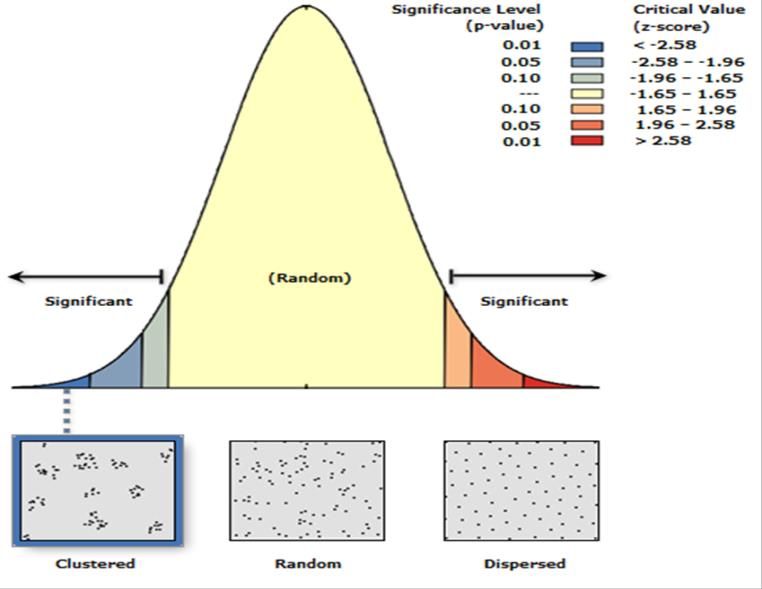
M.A. Oyinloye & O.E. Abiola / IJHSS, 8(2), 29-36, 2021

 Fig.- 3: Spatial distributions of petrol stations Ile-Ife Central
 Source: Author’s Fieldwork (2019)
B. Nearest Neighbour Analysis The values obtained for ranges from zero to 2.15, and
 when its value is: 0
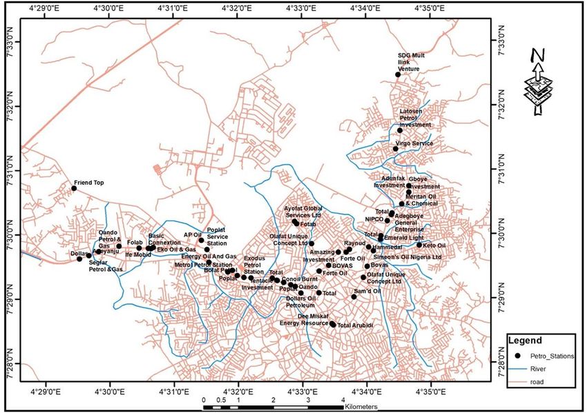
M.A. Oyinloye & O.E. Abiola / IJHSS, 8(2), 29-36, 2021

Ideally, the spatial distribution pattern of facilities should non-compliance to the urban plans and standards by the
be regular for easy accessibility with a minimum standard owners. The spatial pattern of the PFS in the study area
for location between one PFS and the other. On the revealed an unfair competition between fuel station
contrary, the PFS in the study area was located in a owners and the inefficiency of the regulatory bodies.
clustered and irregular pattern that is void of the minimum
spacing standard. This implies that the PFS was closely The irregular spatial distribution of PFS in cities
located in parts of the study area in an irregular, clustered constitutes a social and economic menace to
pattern. The import of cluster distribution of facilities neighbourhoods as queues of vehicles at stations often
prone to high flammability and toxicity pertains to the result in serious traffic congestions. The adjoining
health and safety of lives and properties in the neighbourhood (residential buildings and their occupants)
neighbourhood. This pattern of distribution revealed poor is exposed to danger in case of a fire accident.
enforcement of standards by the regulatory bodies and

 Fig.-4: Nearest neighbour analysis of neighbourhood markets
 Source: Author’s fieldwork, (2019).

Table-3: Nearest neighbour analysis summary of the PFS
Parameters Value

Observed Mean Distance: 307.4650 Meters
Expected Mean Distance: 553.7756 Meters
Nearest Neighbour Ratio: 0.555216
z-score: -6.135950
p-value: 0.000000
Source: Author’s Fieldwork (2019)

 32
M.A. Oyinloye & O.E. Abiola / IJHSS, 8(2), 29-36, 2021

 Table-4: Results of size-area compliance and 8 m buffer of the PFS
 Name Area Area No of Buildings 8m 400 m
 (m2) Compliance within 8m buffer Buffer buffer
 Access Inter Biz 1319 C m2)
 (>=1200 2 (PNC
 to R) (PNC
 to P)
 Adegboye General Enterprise 1471 C 2 NC NC
 Adeyanju 1166 NC 1 NC C
 Adeyemi 2333 C 0 C NC
 Adunfak Investment 1509 C 1 NC NC
 Amazing Investment 811 NC 3 NC NC
 Ap Oil 1050 NC 7 NC NC
 Ayofat Global Services Ltd 537 NC 5 NC NC
 Basic Connextion 1524 C 2 NC NC
 Bofat Petrol 2990 C 0 C NC
 Bovas 760 NC 2 NC NC
 Conoil Burnt 592 NC 5 NC NC
 Dee Miskaf Energy Resource 2034 C 3 NC NC
 Dollars Oil Petroluem 1069 NC 3 NC NC
 Dollas 428 NC 4 NC NC
 Eko Oil &Gas 1337 C 5 NC NC
 Emerald Light 1000 NC 2 NC C
 Energy Oil and Gas 2006 C 1 NC NC
 Exodus Petrol Station 631 NC 4 NC NC
 Folab 1022 NC 0 C NC
 Forte Oil 1512 C 1 NC NC
 Forte Oil 2707 C 2 NC NC
 Fotab 1419 C 4 NC NC
 Friend Top 1105 NC 5 NC NC
 Gboye Investment 523 NC 3 NC NC
 Hammedal 1286 C 1 NC NC
 Ife Mobid 624 NC 6 NC NC
 Keto Oil 501 NC 4 NC NC
 Latosen Petrol Investment 628 NC 2 NC NC
 Meritan Oil & Chemical 1915 C 5 NC NC
 Metrol Petrol Station 3374 C 5 NC NC
 MRC Petrol Station 1613 C 0 C NC
 NIPCO 1055 NC 4 NC NC
 Oando 1284 C 1 NC NC
 Oando Petrol &Gas 1495 C 0 C NC
 Olafat Unique Concept Ltd 829 NC 0 C NC
 Olafat Unique Concept Ltd 2881 C 0 C C
 Poplat 1449 C 2 NC NC
 Poplat 668 NC 2 NC NC
 Poplat Service Station 1150 NC 2 NC NC
 Reynut 1354 C 0 C NC
 Sam'd Oil 1334 C 3 NC NC
 SDg Multi Link Venture 1873 C 1 NC NC
 Segfar Petrol &Gas 672 NC 3 NC NC
 Simeon's Oil Nigeria Ltd 1194 NC 0 C NC
 Tentacle Investment 1216 C 3 NC NC
 Total 1253 C 1 NC NC
 Total 2288 C 2 NC NC
 Total 1184 NC 0 C NC
 Total 5354 C 0 C NC
 Total Arubidi 1719 C 0 C NC
 Virgo Service 316 NC 3 NC NC

 Table-5: Setback to residential land use
Setback to residential land use Frequency Percentage
50 30 57.69
100-150 8 15.38
200-250 5 9.62
300-350 9 17.31
Total 52 100.00
Source: Author’s Fieldwork, (2018)

 33
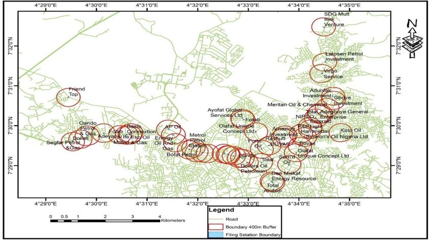
M.A. Oyinloye & O.E. Abiola / IJHSS, 8(2), 29-36, 2021

C. The setback of 50m to residential building pollution (water, land, and air), and health risks are among
 numerous risks associated with the non-compliance. This
The 50 m setback to residential land use is presented in study reveals high non-compliance to distance or setback
Table 5 and shown in Figure 4. The results show that the of residential land use guidelines to the PFS in the study
PFS with 50 m setback of residential land use has the area. Many of the PFS operations did not follow the
highest percentage of 57.7 %, while those with 100 – 150 planning standards before constructing the petrol station(s)
m setback of residential land use is 15.4 %, and those with or a residential building. In the case of any mishaps such
200 – 250 m setback of residential land use is 9.6 %, and as pollution of the environment (air, water, and soil), the
300 – 350 m is 17.3 %. The result of this study reveals that effect could still be feasible on lives and properties within
lives and properties in proximity to the PFS with less than the close proximity.
50 m are at great risk to fire outbreaks, environmental

 Fig.-5: Setback to residential buildings (PFS with 50 m buffer)
 Source: Author’s Fieldwork, (2018)

 Fig.- 6. Distance between two PFS
 Source: Author’s Fieldwork, (2018)

 34
M.A. Oyinloye & O.E. Abiola / IJHSS, 8(2), 29-36, 2021

 Table-6: Proposed factors, their variable names, attributes
 S/N Proposed factors Attributes
 1 Entrepreneurial influence Reason for Location
 2 Factor for location
 3 Site management Other services in Station
 4 Storage capacity
 5 Materials for storage
 6 Coating materials
 7 Planning standards Distance between tanks
 8 Setback to residential land use
 9 Setback to infrastructure
 10 Turning radius
 11 Distance to the road
 12 Distance from health care
 13 Pump setback to the pavement
 14 Environmental-impact assessment Suitability before siting
 15 Assessment before siting
 16 Approval of the government
 17 Original land use
 18 Size of the station
 Source: Author’s Fieldwork (2018)

 Table-7: Correlation of respondents’ responses p-values (Pearson)
Variables Health Type of Water Proximity Opinion Socio- Common
 risk pollution pollution to gas on gas economic ailments
 stations station life
Health risk 0
Type of pollution 0.130 0
Water pollution 0.174 < 0.0001 0
Proximity to gas station 0.530 0.684 0.132 0
Opinion on gas station < 0.0001 0.022 0.046 0.403 0
Social economic life 0.0002 0.052 0.310 0.129 < 0.0001 0
Common ailments < 0.0001 0.006 0.321 0.011 0.213 0.802 0
Values in bold are different from 0 with a significance level alpha=0.05

Table 7. above shows the correlation which exists between 2.There was partial compliance with the principles,
various response variables of the respondents. Health risks standards from concerned regulatory, monitoring planning
presented by siting the PFS close to residential areas are bodies from the side sides of the PFS. No single PFS met
statistically significant to the opinion on gas stations, the cumulative standards.
common ailments, and socio-economic life of the
respondents. 3.Using factor analysis and structural equation modeling,
 five factors were identified to have influenced the choice
The type of pollution experienced by the respondents is factors of locating the PFS, they are owner preferential
statistically significant to water pollution, common choice and planning standards, storage material and factor
ailments, and opinions of respondents on gas stations. of location, environmental impact assessment, type of
Likewise, proximity to the gas stations of the respondents license, and distance between the tanks and site
is significant to the common ailments experienced by the management and administration.
respondents. The opinions of respondents on gas stations
are also statistically significant to the socio-economic life 4.The clustered distribution pattern of the PFS impacted
of the respondents. both the wellbeing of the residents and the environment.
 Traffic congestion, parking inconveniences, noise
 V. CONCLUSION pollution characterized the environmental discomfort
Based on the analysis done and the result obtained or created. Also, air pollution, noise pollution, and water
presented, it can be concluded that: were strongly identified as the resultant effect of the
 services and operations of the PFS. Soil pollution was also
1.The spatial distribution pattern of PFS at Ife Central, identified.
Nigeria, is clustered using the ArcGIS tool.

 35
M.A. Oyinloye & O.E. Abiola / IJHSS, 8(2), 29-36, 2021

5.The services of the PFS had negative impacts on the [2] Asada, D., The petroleum industry in Nigeria: Joint operating
 agreements, memorandum of understandings, compensation and
wellbeing of the residents, as respiratory diseases top the other related issues in perspective,(2010).
list, leukaemia, and nervous breakdown were also [3] Clark, P., & Evans, F., Distance to nearest neighbor as a measure
reported. This confirmed the literature, thus categorizing of spatial relationships in populations. Ecology, 35(4) (1954) 445–
them as long-term non-carcinogenic health problems. 453.
 [4] Iman, A., Ismail, S., & Martin, R., Site potentiality mapping for
Short-term health issues were also reported for being
 petrol filling station based on traffic count within residential
exposed to the vapors of gasoline dispensed by the PFS, neighbourhoods (No. eres_360), (2009). Retrieved from European
and they include fever, diarrhoea, cough, and cold. Real Estate Society website:
 https://ideas.repec.org/p/arz/wpaper/eres2009_360.html
6.The study revealed that there was a high level of [5] Linet, M. S., Yin, S.-N., Travis, L. B., Li, C.-Y., Zhang, Z.-N., Li,
awareness among the residents on the health and D.-G., . . . Group, T. B. S., Clinical features of hematopoietic
 malignancies and related disorders among benzene-exposed
environmental effect of the PFS in the area. At the same workers in China. Environmental Health Perspectives, 104, (1996)
time, there was low awareness among the PFS operators 1353–1364. https://doi.org/10.2307/3433190
on the impact of their activities. [6] National Bureau of Statistics., Nigeria annual abstract
 statistics,(2008).
7.Non-synergetic principles and standards had been [7] Nigeria Population Commission., Official Gazette on the National
 and State Provisional Totals: 2006 Census (No. 24). Lagos,
observed between the regulatory bodies and the local
 Nigeria: Federal Government Printer, 94 (2007).
authorities. [8] Ogundahunsi, D. S., Locational analysis of fuel stations, in Ilesa,
 Osun State, Nigeria. International Journal of Development
 References Strategies in Humanities, Management, and Social Sciences, 4(2)
 [1] Afolabi, O. T., Olajide, F. O., & Omotayo, S. K., Assessment of (2014) 245–258.
 safety practices in filling stations in Ile-Ife, South Western [9] Sangotola, T. M., Fasanmade, P. A., Ayanrinde, W. A., Olatinwo,
 Nigeria, Journal of Community Medicine and Primary Health I. O., & Olaniran, H. F., On the effects of petrol stations in
 care, 23(1-2) (2011) 9-15. Nigeria, International Journal of Science, Engineering and
 Technology Research (IJSETR), 4(4) (2015) 947–954.

 36
You can also read