The Benefits of a Common Map Data Standard for Autonomous Driving - White Paper Navigation Data Standard e. V - NDS Association
←
→
Page content transcription
If your browser does not render page correctly, please read the page content below

White Paper

                     The Benefits of a
     Common Map Data Standard
           for Autonomous Driving
                                   By Philip Hubertus
with contributions by Martin Schleicher, Fabian Klebert, Georg Horn, and Dr. Markus Junker

                         Navigation Data Standard e. V.
White Paper:
The Benefits of a Common Map Data Standard for Autonomous Driving

      The Benefits of a Common Map Data Standard
                for Autonomous Driving

  By Philip Hubertus with contributions by Martin Schleicher, Fabian Klebert, Georg Horn, and Dr. Markus Junker

We have spoken to companies and start-ups that have built self-driving vehicle system
prototypes. The results they showed off were super promising. Even with relatively simple
sensor hardware, many of them were able to achieve good results in a relatively short
development time. Soon they were out there, letting go of the steering wheel, taking their
foot of the pedal, and cruising along highways hands-free. Yet, none of them had access to a
high-definition map, which supports automated driving use cases. Since getting evaluation
access to map data for highly automated driving (HAD) from the big mapping companies is
not easy, they simply focused on what they could get easy access to, in this case, self-
captured data from sensors. The more sophisticated start-ups were combining data from
different kinds of sensors, like cameras, ultrasonic sensors, radar, and lidar. They trained
and improved their AI models on recorded data sets from their test drives – with promising
results.

But is sensor data really enough to fulfill the needs of a self-driving car? Can sensor data
alone power a vehicle that is at least as safe and comfortable as a human chauffeur-driven
car?

1 - A vehicle with SAE level 2 - Partly Automated Driving - features enabled

June 2019                                                                                                         2
White Paper:
The Benefits of a Common Map Data Standard for Autonomous Driving

In order to make safe, reliable, and comfortable automated driving a reality, carmakers must
see maps as a necessary reference for the sensors that enables self-driving cars. We, the
NDS association believe, maps should serve as a common location reference, the common
canvas on which vehicle and infrastructure sensor data are combined to paint a realistic
picture of the world. The map helps the car understand the world around it. And the map
also includes the data that vehicle and infrastructure sensors cannot provide. An example of
such non-detectable data are rules of the road that are not posted on a sign.

2 - A vehicle with SAE level 2 - Partly Automated Driving - features enabled on the German Autobahn

Human drivers make decisions based on experience, intuition and their own knowledge of
the rules and tactics you need behind the wheel. A self-driving car aiming to provide a ride at
least as safe and comfortable as a human chauffeur-driven car needs that and more. Every
millisecond, a self-driving car needs to obtain, evaluate and make decisions based on its
environment. And that environment can change rapidly. The map that fills this role must be
a high definition (HD) map, one that enables vehicles to combine what the sensors see with
the information from the HD map to precisely locate and position the vehicle on the road
and in the lane. With this precise vehicle positioning, the maneuvers of the vehicle will match
the safety and comfort level its passengers expect.

June 2019                                                                                             3
White Paper:
The Benefits of a Common Map Data Standard for Autonomous Driving

Let’s break this down:

•   A map for automated driving needs to include local knowledge of the rules of the road.
    This is information that sensors often cannot collect themselves. Basic driving rules, for
    example, are not generally posted for sensors to “read”, which means that a self-driving
    car relying on sensors alone would not be able to understand and follow the rules. For
    example, a sensor only based self-driving car will encounter situations where it will not
    be able to detect the right-of-way rule for an intersection. Is it then safe to assume the
    default right-of-way rules apply? Since sensors cannot expect to see such rules clearly
    displayed all the time for each unique roadway or intersection, this information needs to
    come from the map, where these rules are attributed to the specific roads and the lanes
    they apply to.

•   A map for automated driving needs to enhance sensor functionality for contextual
    awareness of the environment. With the map as a reference, a self-driving car can
    better understand exactly where it is and compare what it “sees” with its sensors to what
    is coded as attributes into the map data. For example, is the car currently driving on two-
    lane, one-way road, or is the left lane actually intended for oncoming traffic? Is the object
    detected ahead by sensors simply a highway sign or an overpass – or could it something
    else? If it is not coded in map data, this would send a red flag to the vehicle that the
    seemingly harmless object could actually be a physical barrier that, if approached at full
    speed, could prove fatal.

•   A map for automated driving needs to enable the planning of vehicle control maneuvers
    beyond sensor visibility. This enables self-driving cars to slow down before a sharp
    curve, an intersection, or a reduced speed zone, thereby making the ride comfortable
    and safe for the passengers. This is an essential capability, particularly under conditions
    with lower sensor visibility, e.g. due to weather, poor lighting or bad road markings.

•   A map for automated driving needs to allow the precise positioning of a vehicle on the
    road. Understanding where exactly the vehicle is in relation to the road lanes further
    supports all of the three above-mentioned elements. It is critical to leave very little room
    for interpretation on this. For example, whether a car is driving on the highway or on a
    parallel street – or perhaps even a road running underneath on a lower level street or in
    a tunnel – can make an enormous difference with regard to speed limits, lane direction
    and more. By being able to match the vehicle to the exact lane it is driving in, and by
    having additional data points to improve positional accuracy, the behavior of a car
    operating in automated driving mode will be much more comfortable and safer.

June 2019                                                                                         4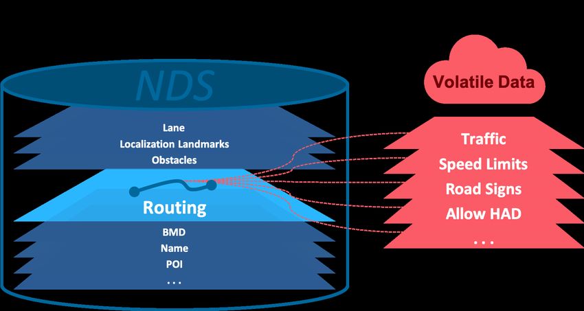
White Paper:
The Benefits of a Common Map Data Standard for Autonomous Driving

You may wonder whether the standard navigation maps of today are not enough already.
Let’s look at the differences of a map for navigation and one for automated driving.

Today’s standard definition maps include road topology
and the link network, in which the centerlines of roads are
coded. Sometimes there is a centerline for each direction
of traffic, but in many cases, only one centerline is coded
for both directions. Clearly, such imprecise and
inconsistent information is insufficient for automated
driving.                                                                                 3 - Road segment with coded
                                                                                         centerlines shown in red

For automated driving, the data needs to be much more
detailed, with lane geometries, lane groups and lane relations. The next level of detail is the
exact lane markings, including their type and color. After that, comes the localization objects
that allow the positioning of the vehicle by including guardrails, signs, lampposts, medians,
gantries, walls and more.

4 - Road segment with coded lane centerlines, coded lane markings, coded localization objects shown in red

The common canvas that unites all of this information is an HD map. This highly detailed
map includes this information and even more, like permanent speed limits, temporary
construction zones or detoured routes. With this level of detail, an HD map can precisely
locate and geo-reference all this data and, along with the vehicle’s sensor data, share it with
others on the road.

By continually comparing the real-time data collected by its sensors with the road and
environmental data stored in the HD map data, vehicles can determine their position
independently of navigation signals, enabling precise positioning that is accurate down to
less than 15 cm laterally and 50 cm longitudinally. The more data collected and shared using
a common referencing system, the more the car can benefit from the data in return.

And there is one additional factor that cannot be underemphasized:
This map needs to have a fast feedback loop with as many participants as possible contributing to
it with their sensor data.

June 2019                                                                                                              5
White Paper:
The Benefits of a Common Map Data Standard for Autonomous Driving

In our diverse, global economy, no single OEM, supplier or system vendor has enough
vehicles in the field equipped with sensor technology to serve all relevant markets entirely
themselves. Automated driving functionalities require high-quality, precise maps that are
always up-to-date. And this needs to be barrier-free, meaning that when you drive your
German car across the border to France, there should still be consistent data available.
Updating such a map by using only your own brand’s vehicle sensor data is simply not
enough to reach the quality and update frequency required to maintain accurate maps. For
example, an OEM with a large number of vehicles in the United States, may not have a
significant volume in Germany or China. Not only would it be unfeasible to expect the same
coverage across the world’s different markets, it is also inefficient and impractical.
Collaboration, data sharing, and using common data standards is a win-win for everyone,
but for that to work, we need to speak the same “language” with a common infrastructure, a
common standard.

The advantages of a common standard for navigation map data are numerous. To name a
few, a common map data standard:

   •   offers data compatibility.
       “Speaking the same language” ensures there is less room for translation error when
       transforming and interpreting data that describes the real world. This is essential to collect
       and compare sensor data with the map that serves as the location reference to increase
       the safety and comfort level of an automated vehicle.
   •   provides ease of access, reducing development costs.
       When developers collaborate, they save valuable time and money. By pooling resources,
       no one has to start from scratch to develop their own systems, because they can pull from
       the extensive expertise and experience of a global network of partners working toward the
       same goal.
   •   increases the data quality, and thereby the safety, reliability and practicality of
       automated vehicles.
       When cars speak the same language and share their data indiscriminately, every car can
       have the most accurate, up-to-the-minute information about its environment, allowing it
       to react to situations more quickly, reliably and safely.
   •   improves the consistency of data and the speed of the feedback loop increases.
       This leaves less room for errors when processing and using data. As a vehicle sensors’
       process data and compares them to the reference map, a common definition help to
       speed up the feedback loop that transfers detected differences back to a system that
       updates the map in near real-time.

June 2019                                                                                          6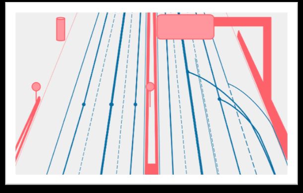
White Paper:
The Benefits of a Common Map Data Standard for Autonomous Driving

     •    increases general road safety for all road users.
          When cars can communicate with each other regardless of make, model or origin,
          accidents can be prevented, our roads become safer and everyone benefits, whether you
          are a driver, passenger, cyclist or pedestrian.
     •    presents legal certainty with respect to IP, contributed to and owned by the
          standard’s members.
     •    supports the sharing of domain knowledge, resulting for example in the full inclusion
          of broad market requirements.

5 – A common map data standard increases the data quality and thereby the safety and reliability of automated vehicles

The Navigation Data Standard (NDS) is the worldwide standard for map data in automotive
eco-systems. Today, map data in NDS format is used in vehicles of over 30 automotive
brands globally since many years. This includes Acura, Aston Martin Lagonda, Audi, Bentley,
BMW, BMW Motorrad, Chrysler, Citröen, DS, Ferrari, Fiat, Hyundai, Jeep, Kia, Lamborghini,
LEVC, Mercedes-Benz, Mercedes-Benz Trucks, MG Motors, MINI, Nissan, Opel, Peugeot,
Porsche, Renault, Seat, Skoda, Smart, Subaru, Toyota, Volkswagen and Volvo.

The NDS association has 38 members: industry leading OEMs, system and solution vendors,
and map data suppliers. The advantage of a consortium like NDS is that it creates broad
consensus in the industry on the best path forward, supported by the best engineers and
experts available from multiple companies. Standardization consortia may not be known for
their fast pace. However, market-driving associations by like-minded companies – as is the
case with NDS – have demonstrated themselves to have the right speed for the market.

June 2019                                                                                                                7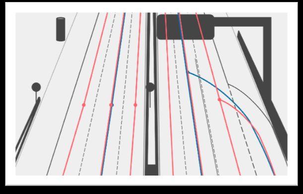
White Paper:
The Benefits of a Common Map Data Standard for Autonomous Driving
The members of the NDS Association have defined the data specification for an HD map to
support automated vehicles. Established map data providers, as well as newcomers, are
offering their high definition maps in NDS, and a number of OEMs are using the standard to
develop and test automated vehicles today.
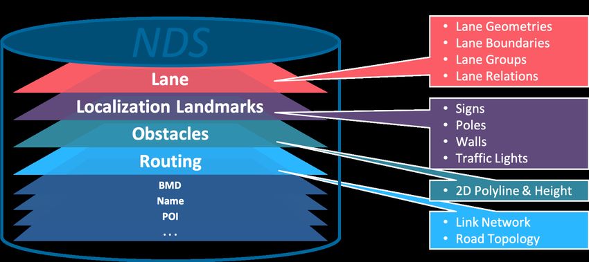
For HAD, the NDS map data format offers four specific building blocks that layer the data
and references it to each other:
1. The NDS Lane Building Block contains advanced lane information for HAD and
enhanced navigation functionality. It represents an attribute layer for highly detailed
lane geometry and provides the data for precise guidance instructions and advanced
lane guidance functionality, since navigation systems for HAD need detailed
information on road topology and road geometry.
Usually, roads are digitized as a single polyline for each roadway independent of the
number of lanes. For HAD, it is insufficient to encode the number of lanes and the
connections between lanes only. The following information is also important:
• Geometry of lanes and lane boundaries, such as physical lane dividers
• Road markings, such as arrows
• Possibilities of changing lanes
• Associated lanes, such as lanes in opposite directions
Lane properties that contain the information required by navigation systems for HAD
may be described by attribute groups that combine lane attributes with validity
ranges.
2. The NDS Obstacle Building Block provides data structures that allow the modeling
of obstacles along the road edges. Obstacles are generic, stationary objects that
reside along the road and can be used for positioning, for example, guardrails, walls,
fences, or small hills near the road.
3. The Localization Landmark Building Block provides data structures that allow the
modeling of landmarks that can be used for positioning. Localization landmarks
represent real-word objects, such as signs, traffic lights, road markings, road-side
equipment like posts and poles, or perpendicular walls. If the sensors of a vehicle
detect localization landmarks along the road, the system can use these to determine
the vehicle's position.
For each localization landmark, a bounding box with an absolute geographic position
and height values, or a center line is defined. To model relations between routing
June 2019 8
White Paper:
The Benefits of a Common Map Data Standard for Autonomous Driving

           features and localization landmarks, feature references between the base links and
           road geometry lines and the landmarks are defined. This information enables the
           application to validate the localization landmark's position in relation to the assumed
           current car position.

     4. The Routing Building Block provides the underlying link network for the other
           building blocks. Applications need this link information to enable car positioning.

6 - Illustration of NDS database building blocks with selected attribute lists

In addition to storing this data as a full on-board database, the data relevant for automated
driving can be consumed tile-based, via an application programming interface (API). The
collected and shared sensor data that is highly dynamic and changes often can be
referenced to the map data and then offered via APIs. Automated vehicles can consume this
data as they need it. For HAD, you must think of traffic data, hazard warnings, dynamic
speed limits and road signs, and safety flags that indicate whether a road segment is safe
and accessible.

As part of the NDS data specification, the members have defined how volatile location IDs
can be used to support use cases were data with an extremely high frequency of changes is
combined with map data that doesn’t need the same high frequency of updates. This is to
ensure NDS enables data transfer bandwidth and costs to be used as efficiently as possible.

June 2019                                                                                        9
White Paper: The Benefits of a Common Map Data Standard for Autonomous Driving 7 - Illustration of NDS database with reference from routing building block to volatile data layers The currently latest version of NDS is version 2.5 and its specification includes data format definitions for the above. Nevertheless, the NDS format is evolving to a new generation of specifications that is focused on enabling a combination of embedded and streamable data. This is specifically targeted at even better supporting highly and full automated driving with map data. It is also addressing the fact that navigation is shifting from pure offline and embedded models to hybrid models. Map data that is not changing often, for example the digital terrain model or icons and country meta data, remains embedded, while map data attributes that change more frequently are streamed to the vehicle on demand. Hybrid also means, features like search, route calculation and traffic-related recalculations, as well as other high data and computational features, can move to servers. This includes cloud- connected dynamic data services derived from infrastructure and vehicle sensors. On the server side, NDS is used to ensure data integrity and a seamless user experience in case a data connection is not possible. While NDS spec 2.5 will continue to be maintained as NDS.Classic, the new evolution of NDS is called NDS.Live. NDS.Live comes highly modularized to scale across usage scenarios in the car, in the edge network (5G), and in the cloud. With its focus on HAD, functional safety, and seamless map data distribution. NDS.Live widens the scope of the format to better include online electronic horizon services and dynamic map management to generate a truly distributed map experience for NDS developers and OEMs. The NDS Association drafted a first version of NDS.Live in May 2019. Further specification work will continue to migrate current NDS features, as well as add new functionality, for June 2019 10
White Paper:
The Benefits of a Common Map Data Standard for Autonomous Driving

example, to improve HAD support in urban scenarios and to integrate lessons learned into
the new architecture. The target of the version 1.0 release of NDS.Live is in 2020.

The NDS association members invite companies to join the association and the shared
patent pool of the Navigation Data Standard, which is THE worldwide standard for map data
in automotive eco-systems. Together we will define the format specification of the digital
map and its interfaces.

Learn more about NDS at www.nds-association.org and feel free to contact
Martin Schleicher, NDS Association Chairman,
martin.schleicher@nds-association.org or
Dr. Markus Junker, NDS Association Administration,
markus.junker@nds-association.org

About NDS

NDS, short for Navigation Data Standard, is the worldwide standard for map data in
automotive eco-systems.

NDS maps work worldwide and are globally adopted. NDS members and map coverage
include North America, EMEA, APAC, including China, South Korea, and Japan. NDS offers a
well-defined spec for how to store map data and it allows flexibility for customized user
experiences. The NDS specification covers the data model, storage format, interfaces, and
protocols. NDS is for in-vehicle navigation and for ADAS and e-horizon safety systems. It is
for mobile companion apps, connected car cloud solutions, and for automated driving. It
evolves with the market needs as NDS is for the automotive industry, by the automotive
industry.

The NDS association has 38 members: Automotive OEMs, system and solution vendors, and
map data suppliers.

The advantage of a consortium like NDS is that it creates broad consensus in our industry on
the best path forward, made by the best engineers and expert available from multiple
companies. Standardization consortia may not be known for a fast pace. However, market
driving associations by like-minded companies - as it is the case with NDS - demonstrated to
have the right speed for the market.

June 2019                                                                                      11
You can also read