LUNAR AND PLANETARY - HAYABUSA2: Bringing Home a Mystery
←
→
Page content transcription
If your browser does not render page correctly, please read the page content below
HAYABUSA2: Bringing
           Issue #154

Home a Mystery
Featured Story · News from Space · The Lunar and Planetary Institute’s 50th Anniversary Science Symposium ·
Meeting Highlights · Opportunities for Students · Spotlight on Education · In Memoriam · Milestones ·
New and Noteworthy · Calendar

LUNAR AND PLANETARY
INFORMATION BULLETIN
October 2018       Issue 154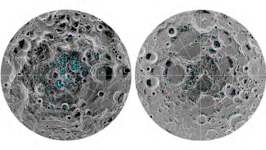
Issue #154 2 of 53 October 2018
Featured Story
Hayabusa2: Bringing Home a Mystery
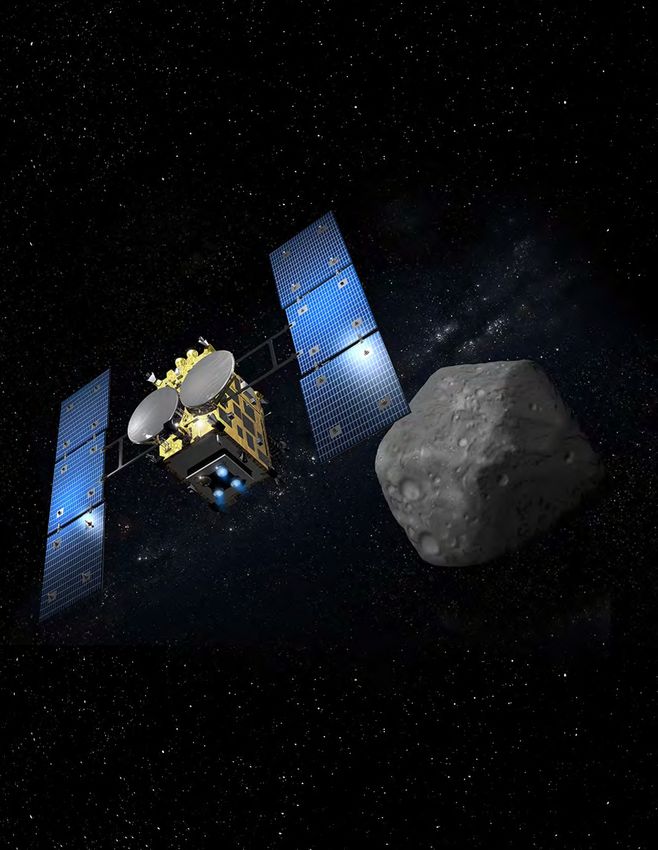
On May 9, 2003, the Japanese Aerospace Exploration Agency (JAXA) launched Hayabusa, the first mission to return an asteroid sample back to Earth.
Fifteen years later, JAXA, in partnership with the European Space Agency (ESA), has sent a second mission to rendezvous with an asteroid, with the
objective of returning yet another sample. Both Hayabusa missions were designed to provide insight and understanding into the building blocks of
the solar system. Hayabusa brought us back pieces of 25143 Itokawa, an S-class asteroid. Hayabusa2 is on course to return samples from
162173 Ryugu, a C-class asteroid. This sample will be the first returned from a C-class asteroid.
The Spacecraft
Hayabusa2 launched on December 3, 2014, and arrived at its target, Ryugu, on June 27, 2018. This bold, exciting mission has raised the bar on its
predecessor by including a lander (the Mobile Asteroid Surface Scout, MASCOT, a collaboration with ESA) and three MINERVA_II rovers, as well as
targeting three touchdowns to sample the surface.
The sampling payload also includes the Small Carry-on Impactor (SCI), designed to create a crater on the surface of Ryugu. This crater will enable the
spacecraft to sample more pristine materials from below the space-weathered surface. The artificially created crater will also help to measure crater
scaling properties, which will provide scientists with information needed to more accurately date the surface. The main spacecraft hosts a payload
that includes the Optical Navigation Camera (ONC) system, which contains two wide-angle cameras (ONC-W1 and ONC-W2, whose primary purpose is
to provide optical navigation, but has also been employed to monitor the release and decent of the lander and rovers) and a narrow-angle camera
(ONC-T, equipped with seven color filters to measure the broadband spectral behavior in the visible), the Light Detection and Ranging (LIDAR)
altimeter (also used for navigation during the lander release, rover release, and sampling operations), the Thermal-Infrared Imager (TIR), and the
Near-Infrared Spectrometer (NIRS3). The Deployable Camera (DCAM3) is a releasable imager, whose purpose is to image the cratering event prior to
sampling while the main spacecraft hides from the ejecta.
The ESA-provided MASCOT lander contains its own payload for examining the surface. MASCOT carries a magnetometer, a radiometer, an infrared
spectrometer, and a camera capable of imaging the small-scale structures and textures of the regolith (the ground-up top layer of the surface).
MASCOT has the capability to “tumble” and reposition itself across the local surface, thus providing the mission with the capability to characterize the
regolith at multiple locations. MASCOT was deployed to Ryugu’s surface on October 3, 2018, and collected data for 17 hours until its battery ran out.
The MIcro-Nano Experimental Robot Vehicle for the Asteroid (MINERVA)-II rovers are successors to the MINERVA lander on the original Hayabusa
mission. MINERVA-II-1 carries rovers Rover-1A and Rover-1B, which were developed by JAXA. They move by hopping within Ryugu’s microgravity. Their
payload includes stereo and wide-angle cameras and a thermometer. MINERVA-II-2 carries a single rover, Rover-2, developed by a consortium of
Japanese universities led by Tohoku University. It also travels by hopping across the surface. Its payload consists of two cameras, a thermometer, and
an accelerometer. The MINERVA-II-1 rovers were deployed to Ryugu’s surface on September 21, 2018. As they are solar powered, they are still
operating. MINERVA-II-2 will be deployed in mid-2019.
The Target
Ryugu is a C-class asteroid, approximately 1 kilometer in diameter. C-class asteroids are believed to represent the most primitive bodies in our solar
system, with chemical compositions similar to the Sun and the early solar nebula. Such objects often contain hydrated minerals and carbon-
containing materials, compositions that explain their generally dark albedos. C-class asteroids are believed to be the source of the carbonaceous
chondrite meteorites collected here on Earth.
Ryugu is also a near-Earth asteroid, and therefore has an orbit that not only approaches that of Earth, but also brings it closer to the Sun than
asteroids that reside in the main belt (located between the orbits of Mars and Jupiter). Ryugu’s surface is alternately heated and cooled by the Sun as
it rotates, which contributes to the thermal processing of the surface.
Prior to Hayabusa2’s encounter with Ryugu, little was known of this asteroid. Groundbased spectra indicated that it was a dark object, but few
diagnostic mineral features were seen. The presence of the hydrated mineral feature typically observed at 0.7 micrometers was present in some, but
not all, observations. The early data returned from Hayabusa2 have shown that Ryugu is still quite mysterious.
The first images of Ryugu (Fig. 1) revealed a top-shaped object with an orbital period of ~7.6 hours. Ryugu displays a dark, rocky, hummocky surface.
There are boulders everywhere! Boulders of various sizes are strewn across the entire surface, making the selection of touchdown (for sampling) and
landing sites (for the safe decent of landers and rovers) extremely challenging. Distinctive features include craters and a ridge along the asteroid’s
equator, along with a large boulder near the south pole (top of image). Ryugu rotates in a retrograde direction, thus placing the “south pole” at the top
of the image.
Copyright 2018 Lunar and Planetary Institute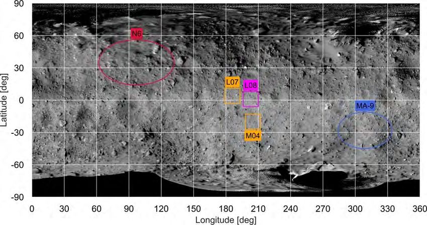
Issue #154                                                        3 of 53                                               October 2018

                                    Fig. 1. Image of the asteroid 162173 Ryugu taken on June 30, 2018, shortly after
                                    arrival into the home position, 20 kilometers from the asteroid. In this image, south
                                    is at the top. A large boulder can be seen at the south pole (top of image, as Ryugu is
                                    a retrograde rotator). Credit: JAXA, Tokyo University, Kochi University, Rikkyo
                                    University, Nagoya University, Chiba Institute of Technology, Meiji University, Aizu
                                    University, and AIST.

The home position for the spacecraft is a “parked orbit” where the spacecraft essentially hovers 20 kilometers above the surface and the instruments
observe the asteroid as it rotates beneath it. Images acquired from 6 kilometers (Fig. 2) and 64 meters (Fig. 3) above the surface show that the terrain
on this asteroid remains very rocky even at higher spatial scales.

                                                       Copyright 2018 Lunar and Planetary Institute
Issue #154                                                        4 of 53                                             October 2018

                                   Fig. 2. This image of 162173 Ryugu was acquired on July 20, 2018 from an altitude
                                   of 6 kilometers. The large crater on the equator, which makes Ryugu resemble a
                                   beaten up Death Star, is seen in the center of the image. Credit: JAXA, Tokyo
                                   University, Kochi University, Rikkyo University, Nagoya University, Chiba Institute of
                                   Technology, Meiji University, Aizu University, and AIST.

                                   Fig. 3. This image taken by the ONC-T from 64 meters altitude shows that even at
                                   higher spatial scales the surface of Ryugu remains very rocky. Credit: JAXA, Tokyo
                                   University, Kochi University, Rikkyo University, Nagoya University, Chiba Institute of
                                   Technology, Meiji University, Aizu University, and AIST.

Images taken with the TIR (Fig. 4) indicate that the temperatures across Ryugu’s surface are not uniform. In fact, images taken from the home position
shortly after arrival show the northern hemisphere is warmer than the southern hemisphere.

                                                      Copyright 2018 Lunar and Planetary Institute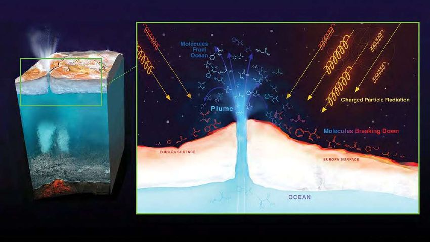
Issue #154                                                        5 of 53                                               October 2018

                                    Fig. 4. Images of 162173 Ryugu taken by the TIR on June 30, 2018, show that the
                                    northern hemisphere is much warmer than the southern hemisphere. The numbers
                                    on the scale are relative, where blue indicates colder regions and red indicates
                                    warmer regions. Credit: JAXA, Ashikaga University, Rikkyo University, Chiba Institute
                                    of Technology, Aizu University, Hokkaido University of Education, Hokkaido
                                    Kitamihito.

The Mission

The mission plan is an exciting blend of landers, rovers, an impact experiment, and sample collection, in addition to the intriguing observations to be
acquired from the main spacecraft. Operations are defined by spacecraft position, where observations taken from the 20-kilometer “home position”
are considered to be Box-A operations (Fig. 5). Box-B operations are conducted at the same altitude as Box-A; however, they include maneuvers of
the spacecraft in the horizontal direction with respect to the initial Box-A position. Box-C observations are those where the spacecraft remains in a
parked position but lowers its altitude. For example, images were acquired from 1000 meters above Ryugu during Box-C activities with both the ONC
wide-angle and telescopic cameras. These images provide the science team with high-spatial-resolution images that can be used along with lower-
resolution images to keep the observations in global context (Fig. 6).

                                                       Copyright 2018 Lunar and Planetary Institute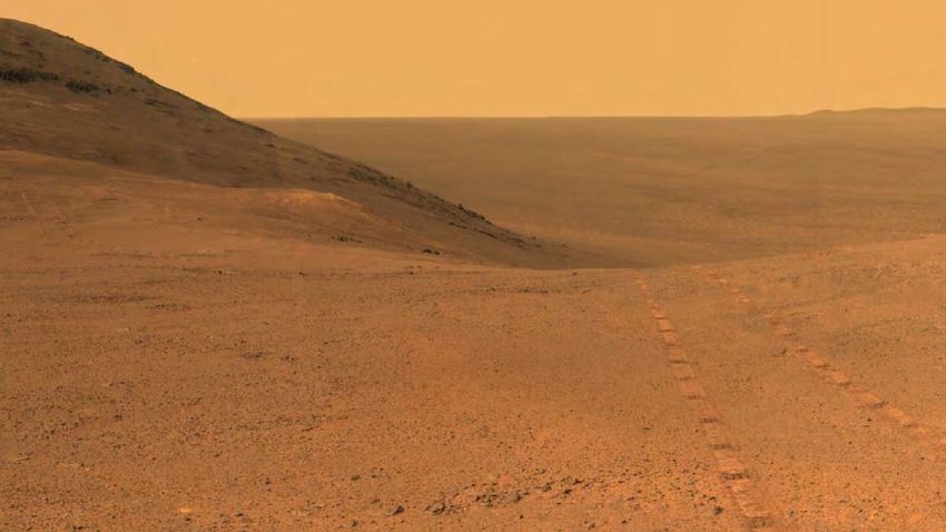
Issue #154                                          6 of 53                                         October 2018

             Fig. 5. This diagram displays the different spacecraft operational zones designed to
             investigate Ryugu.

                               Copyright 2018 Lunar and Planetary Institute
Issue #154                                                       7 of 53                                            October 2018

                                   Fig. 6. This image was taken by the ONC-W1 camera during the touchdown
                                   rehearsal operations October 14–16, 2018. The shadow of the Hayabusa2
                                   spacecraft can clearly be seen on the surface of Ryugu. Credit: JAXA, Tokyo
                                   University, Kochi University, Rikkyo University, Nagoya University, Chiba Institute of
                                   Technology, Meiji University, Aizu University, and AIST.

Hayabusa2 has wrapped up its early mission operations phase and has segued into its landed operations. The MINERVA-II-1 rovers are currently active
on the surface. Images acquired from the rovers show a highly rocky terrain (Fig. 7). ESA’s MASCOT lander, successfully deployed on October 3, 2018,
has also been operating on the surface. Images acquired by the ONC wide-angle camera captured the deployment of the MASCOT lander onto the
surface (Fig. 8).

                                   Fig. 7. This image of Ryugu’s surface was taken by Rover-1B on September 23, 2018,
                                   after landing on the surface. This image shows that the surface is rocky, even at
                                   small spatial scales.

                                                      Copyright 2018 Lunar and Planetary Institute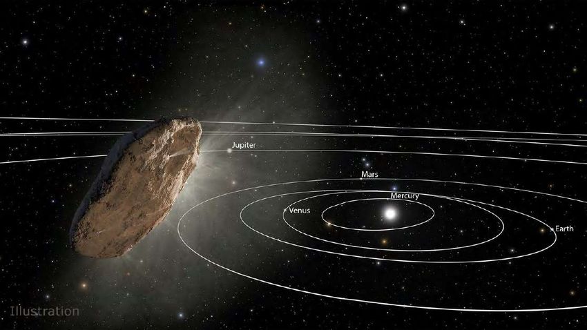
Issue #154                                                         8 of 53                                                       October 2018

                                     Fig. 8. The MASCOT lander’s (upper left side of the image) deployment onto the
                                     surface of Ryugu was captured by the ONC-W1. Here MASCOT is still above the
                                     surface.

The first of the three touchdown and sample retrievals is planned for early 2019, after the spacecraft comes out of solar conjunction (which lasts from
late November through December 2018). Landing site selections (Fig. 9) were made primarily based on safety factors (minimizing large boulders and
surface slopes) as well as selecting a site that might offer the best opportunity to understand Ryugu’s mineralogy. The strategy has been to select sites
that offer an opportunity to return the least-processed, most-pristine materials possible.

                      Fig. 9. Location of the landing sites for MINERVA-II-1 (N6), MASCOT (MA-9), and the first touchdown sample
                      collection (L08) with touchdown backup sites (L07 and M04). Credit: JAXA, Tokyo University, Kochi University,
                      Rikkyo University, Nagoya University, Chiba Institute of Technology, Meiji University, Aizu University, and AIST.

Early next year, JAXA will start the sample collection phase of the mission in three parts. The first two consist of floating down to the surface, and firing
solid metal slugs into the regolith. The goal is to launch dust toward the probe for collection. The third requires Hayabusa2 to access material that’s
currently buried beneath the surface. It will use a small explosive projectile to make a crater before diving in to scoop up material. In total, JAXA hopes
to send 100 milligrams of dust back to Earth.

Hayabusa2 is well on its way to meeting all three of the mission’s objectives. The first is to expand our scientific knowledge. By analyzing Ryugu’s
materials, we will get closer to learning about the solar system’s origins and evolution, as well as the emergence and history of life. We know that the
asteroid contains carbon, so we could discover water or organic materials, which are the basic building blocks of life.

The second objective is to maintain and develop the technology for exploring outer space. This precision explorer’s construction is the sum of
technological, scientific, and industrial capability. It is important for us to use the experience we’ve gained in order to make our space technology even
more sophisticated.

The third objective is to venture out into the frontier and broaden the range of human activity in space. Hayabusa2 will have a ripple effect in industry
and society, and will provide an educational experience for today’s youth. Space exploration missions are not short-term projects, and we will need
the help of today’s younger generation. We will teach the people who will succeed us, and continue the exploration of space.

                                                        Copyright 2018 Lunar and Planetary Institute
Issue #154                                                      9 of 53                                                     October 2018

The Lunar and Planetary Information Bulletin collects, synthesizes, and disseminates current research and findings in the planetary
sciences to the research community, science libraries, educators, students, and the public. The Bulletin is dedicated to engaging,
exciting, and educating those with a passion for the space sciences while developing future generations of explorers.

The Bulletin welcomes articles dealing with issues related to planetary science and exploration. Of special interest are articles describing
web-based research and educational tools, meeting highlights and summaries, and descriptions of space missions. Peer-reviewed
research articles, however, are not appropriate for publication in the Bulletin. Suggested topics can be e-mailed to the editors, who will
provide guidelines for formatting and content.

Dr. Paul Schenk, Scientific Editor (schenk@lpi.usra.edu)

Renée Dotson, Production Editor (rdotson@hou.usra.edu)

The Bulletin is published on a quarterly schedule (January, April, July, and October). The copy deadline is the 15th of the month
immediately preceding publication.

To be added to the list to receive notification by e-mail of future issues, please visitwww.lpi.usra.edu/forms/newsletter/.

The Bulletin is published by the Lunar and Planetary Institute (LPI), 3600 Bay Area Boulevard, Houston TX 77058. Material in this issue
may be copied without restraint for library, abstract service, education, or personal research purposes.

ISSN 1534-6587

The LPI is operated by the Universities Space Research Association under Award No. NNX15AL12A from the Science Mission Directorate
of the National Aeronautics and Space Administration. Any opinions, findings, and conclusions or recommendations expressed in this
issue are those of the author(s) and do not necessarily reflect the views of the National Aeronautics and Space Administration.

                                               Copyright 2018 Lunar and Planetary Institute
Issue #154                                                        10 of 53                                                    October 2018

News From Space
Martian Skies Clearing Over Opportunity Rover

 Opportunity’s panoramic camera (Pancam) took the component images for this view from a position outside Endeavor Crater during the span of June 7 to
 June 19, 2017. Toward the right side of this scene is a broad notch in the crest of the western rim of crater. Credit: NASA/JPL-Caltech/Cornell/Arizona State
 University.

A planet-encircling dust storm on Mars, which was first detected May 30 and halted operations for the Opportunity rover, continues to abate.

With clearing skies over Opportunity’s resting spot in Mars’ Perseverance Valley, engineers at NASA’s Jet Propulsion Laboratory in Pasadena,
California, believe the nearly 15-year-old, solar-powered rover will soon receive enough sunlight to automatically initiate recovery procedures — if the
rover is able to do so. To prepare, the Opportunity mission team has developed a two-step plan to provide the highest probability of successfully
communicating with the rover and bringing it back online.

“The Sun is breaking through the haze over Perseverance Valley, and soon there will be enough sunlight present that Opportunity should be able to
recharge its batteries,” said John Callas, Opportunity project manager at JPL. “When the tau level [a measure of the amount of particulate matter in
the martian sky] dips below 1.5, we will begin a period of actively attempting to communicate with the rover by sending it commands via the antennas
of NASA’s Deep Space Network. Assuming that we hear back from Opportunity, we will begin the process of discerning its status and bringing it back
online.”

The rover’s last communication with Earth was received June 10, and Opportunity’s current health is unknown. Opportunity engineers are relying on
the expertise of Mars scientists analyzing data from the Mars Color Imager (MARCI) aboard NASA’s Mars Reconnaissance Orbiter (MRO) to estimate
the tau near the rover’s position.

“The dust haze produced by the martian global dust storm of 2018 is one of the most extensive on record, but all indications are it is finally coming to
a close,” said MRO Project Scientist Rich Zurek at JPL. “MARCI images of the Opportunity site have shown no active dust storms for some time within
about 1,900 miles (3,000 kilometers) of the rover site.”

With skies clearing, mission managers are hopeful the rover will attempt to call home, but they are also prepared for an extended period of silence. “If
we do not hear back after 45 days, the team will be forced to conclude that the Sun-blocking dust and the martian cold have conspired to cause some
type of fault from which the rover will more than likely not recover,” said Callas. At that point, the team will report to NASA HQ to determine whether
to continue with the strategy or adjust it. Callas added, “In the unlikely chance that there is a large amount of dust sitting on the solar arrays that is
blocking the Sun’s energy, we will continue passive listening efforts for several months.”

The additional several months for passive listening are an allowance for the possibility that a Red Planet dust devil could come along and literally dust
off Opportunity’s solar arrays. Such “cleaning events” were first discovered by Mars rover teams in 2004 when, on several occasions, battery power
levels aboard both Spirit and Opportunity increased by several percent during a single martian night, when the logical expectation was that they
would continue to decrease. These cleaning dust devils have even been imaged by both rovers on the surface and spacecraft in orbit.
                                                      Copyright 2018 Lunar and Planetary Institute
Issue #154 11 of 53 October 2018
The chances are small that dust accumulation would be the root cause of Opportunity’s lack of communication. Nonetheless, each day during the
passive phase, JPL’s Radio Science group will scour the signal records taken by a very sensitive broadband receiver of radio frequencies emanating
from Mars, looking for a sign that the rover is trying to reach out.
Even if the team hears back from Opportunity during either phase, there is no assurance the rover will be operational. The impact of this latest storm
on Opportunity’s systems is unknown but could have resulted in reduced energy production, diminished battery performance, or other unforeseen
damage that could make it difficult for the rover to fully return online.
While the situation in Perseverance Valley is critical, the rover team is cautiously optimistic, knowing that Opportunity has overcome significant
challenges during its 14-plus years on Mars. The rover lost use of its front steering — its left-front in June of 2017, and right front in 2005. Its 256-
megabyte flash memory is no longer functioning. The team also knows that everything about the rover is well beyond its warranty period — both
Opportunity and its twin rover, Spirit, were constructed for 90-day missions (Spirit lasted 20 times longer and Opportunity is going on 60 times). The
rovers were designed to travel about 1,000 yards, and Opportunity has logged more than 28 miles. Through thick and thin, the team has seen their
rover soldier on. Now, Opportunity engineers and scientists of Opportunity are planning, and hoping, that this latest dilemma is just another bump in
their martian road.
“In a situation like this you hope for the best but plan for all eventualities,” said Callas. “We are pulling for our tenacious rover to pull her feet from the
fire one more time. And if she does, we will be there to hear her.”
For the current status of Opportunity, visit https://mars.nasa.gov/mer/mission/status_opportunityAll.html.
Ice Confirmed at the Moon’s Poles
The image shows the distribution of surface ice at the Moon’s south pole (left) and north pole (right), detected by NASA’s Moon Mineralogy Mapper
instrument. Blue represents the ice locations, plotted over an image of the lunar surface, where the gray scale corresponds to surface temperature (darker
representing colder areas and lighter shades indicating warmer zones). The ice is concentrated at the darkest and coldest locations, in the shadows of
craters. This is the first time scientists have directly observed definitive evidence of water ice on the Moon’s surface. Credit: NASA.
In the darkest and coldest parts of its polar regions, a team of scientists has directly observed definitive evidence of water ice on the Moon’s surface.
These ice deposits are patchily distributed and could possibly be ancient. At the southern pole, most of the ice is concentrated at lunar craters, while
the northern pole’s ice is more widely, but sparsely spread.
A team of scientists, led by Shuai Li of the University of Hawaii and Brown University and including Richard Elphic from NASA’s Ames Research Center
3
in California’s Silicon Valley, used data from NASA’s Moon Mineralogy Mapper (M ) instrument to identify three specific signatures that definitively
prove there is water ice at the surface of the Moon.
3
M , onboard the Chandrayaan-1 spacecraft launched in 2008 by the Indian Space Research Organization, was uniquely equipped to confirm the
presence of solid ice on the Moon. It collected data that not only picked up the reflective properties expected from ice, but was able to directly
measure the distinctive way its molecules absorb infrared light, so it could differentiate between liquid water or vapor and solid ice.
Copyright 2018 Lunar and Planetary InstituteIssue #154 12 of 53 October 2018
Most of the newfound water ice lies in the shadows of craters near the poles, where the warmest temperatures never reach above –250°F. Because of
the very small tilt of the Moon’s rotation axis, sunlight never reaches these regions.
Previous observations indirectly found possible signs of surface ice at the lunar south pole, but these could have been explained by other
phenomena, such as unusually reflective lunar soil.
With enough ice sitting at the surface — within the top few millimeters — water would possibly be accessible as a resource for future expeditions to
explore and even stay on the Moon, and potentially easier to access than the water detected beneath the Moon’s surface.
Learning more about this ice, how it got there, and how it interacts with the larger lunar environment will be a key mission focus for NASA and
commercial partners for future lunar exploration.
Bricks from Moon Dust
Lunar masonry starts on Earth. European
researchers are working with Moon dust simulants
that could one day allow astronauts to build
habitats on our natural satellite and pave the way
for human space exploration.
The surface of the Moon is covered in grey, fine,
rough dust. This powdery soil is everywhere — an
indigenous source that could become the ideal
material for brickwork. You can crush it, burn it and
compress it.
“Moon bricks will be made of dust,” says Aidan
Cowley, ESA’s science advisor with a wealth of
experience in dealing with lunar soil. “You can
create solid blocks out of it to build roads and
launch pads, or habitats that protect your
astronauts from the harsh lunar environment.”
This 1.5-metric-ton building block was produced as a demonstration of 3D printing techniques European teams see Moon dust as the starting
using lunar soil. The design is based on a hollow closed-cell structure — reminiscent of bird bones point to building up a permanent lunar outpost and
— to give a good combination of strength and weight. Credit: ESA. breaking explorers’ reliance on Earth supplies.
Lunar soil is a basaltic material made up of
silicates, a common feature in planetary bodies with volcanism.
“The Moon and Earth share a common geological history, and it is not difficult to find material similar to that found on the Moon in the remnants of
lava flows,” explains Cowley.
Around 45 million years ago, eruptions took place in a region around Cologne, in Germany. Researchers from the nearby European Astronaut Centre
(EAC) found that the volcanic powder in the area is a good match with what lunar dust is made of. And there is plenty of it.
The lunar dust substitute “made in Europe” already has a name: EAC-1.
The Spaceship EAC initiative is working with EAC-1 to prepare technologies and concepts for future lunar exploration.
“One of the great things about the lunar soil is that 40% of it is made up of oxygen,” adds Cowley. One Spaceship EAC project studies how to crack the
oxygen in it and use it to help astronauts extend their stay on the Moon.
Bombarded with constant radiation, lunar dust is electrically charged. This can cause particles to lift off the surface. Erin Tranfield, a member of ESA’s
lunar dust topical team, insists that we still need to fully understand its electrostatic nature.
Scientists do not yet know its chemical charge, nor the consequences for building purposes. Trying to recreate the behavior of lunar dust in a radiation
environment, Erin ground the surface of lunar simulants. She managed to activate the particles, but erased the properties of the surface.
“This gives us one more reason to go back to the Moon. We need pristine samples from the surface exposed to the radiation environment,” says
Tranfield. For this biologist who dreams of being the first woman on the Moon, a few sealed grams of lunar dust would be enough.
For more information, visit https://www.esa.int/Our_Activities/Human_Spaceflight/Exploration/Bricks_from_Moon_dust.
Mars Express Detects Liquid Water Hidden Under Planet’s South Pole
Copyright 2018 Lunar and Planetary InstituteIssue #154 13 of 53 October 2018
ESA’s Mars Express has used radar signals bounced through underground layers of ice to identify a
pond of water buried below the surface. This image shows an example radar profile for one of 29
orbits over the study region in the south polar region of Mars. The bright horizontal feature at the
top corresponds to the icy surface of Mars. The brightest reflections from the base layer — close to
the center of this image — show a 20-kilometer-wide subsurface anomaly interpreted as a pond
of liquid water. Credit: ESA/NASA/JPL/ASI/Univ. Rome.
Radar data collected by ESA’s Mars Express point to a pond of liquid water buried under layers of ice and dust in the south polar region of Mars.
Evidence for the Red Planet’s watery past is prevalent across its surface in the form of vast dried-out river valley networks and gigantic outflow
channels clearly imaged by orbiting spacecraft. Orbiters, together with landers and rovers exploring the martian surface, also discovered minerals
that can only form in the presence of liquid water.
But the climate has changed significantly over the course of the planet’s 4.6 billion year history and liquid water cannot exist on the surface today, so
scientists are looking underground. Early results from the 15-year old Mars Express spacecraft already found that water ice exists at the planet’s
poles and is also buried in layers interspersed with dust.
The presence of liquid water at the base of the polar ice caps has long been suspected; after all, from studies on Earth, it is well known that the
melting point of water decreases under the pressure of an overlying glacier. Moreover, the presence of salts on Mars could further reduce the melting
point of water and keep the water liquid even at below-freezing temperatures.
But until now evidence from the Mars Advanced Radar for Subsurface and Ionosphere Sounding instrument (MARSIS), the first radar sounder ever to
orbit another planet, remained inconclusive.
It has taken the persistence of scientists working with this subsurface-probing instrument to develop new techniques in order to collect as much high-
resolution data as possible to confirm their exciting conclusion.
Ground-penetrating radar uses the method of sending radar pulses towards the surface and timing how long it takes for them to be reflected back to
the spacecraft, and with what strength. The properties of the material that lies between influences the returned signal, which can be used to map the
subsurface topography.
The radar investigation shows that the south polar region of Mars is made of many layers of ice and dust down to a depth of about 1.5 km in the 200
km-wide study area. A particularly bright radar reflection underneath the layered deposits is identified within a 20 km-wide zone.
Analyzing the properties of the reflected radar signals and considering the composition of the layered deposits and expected temperature profile
below the surface, the scientists interpret the bright feature as an interface between the ice and a stable body of liquid water, which could be laden
with salty, saturated sediments. For MARSIS to be able to detect such a patch of water, it would need to be at least several tens of centimeters thick.
“This subsurface anomaly on Mars has radar properties matching water or water-rich sediments,” says Roberto Orosei, principal investigator of the
MARSIS experiment and lead author of the paper published in the journal Science. “This is just one small study area; it is an exciting prospect to think
there could be more of these underground pockets of water elsewhere, yet to be discovered.”
“We’d seen hints of interesting subsurface features for years but we couldn’t reproduce the result from orbit to orbit, because the sampling rates and
resolution of our data was previously too low,” adds Andrea Cicchetti, MARSIS operations manager and a co-author on the paper. “We had to come up
with a new operating mode to bypass some onboard processing and trigger a higher sampling rate and thus improve the resolution of the footprint of
our dataset: now we see things that simply were not possible before.”
The finding is somewhat reminiscent of Lake Vostok, discovered some 4 km below the ice in Antarctica on Earth. Some forms of microbial life are
known to thrive in Earth’s subglacial environments, but could underground pockets of salty, sediment-rich liquid water on Mars also provide a suitable
habitat, either now or in the past? Whether life has ever existed on Mars remains an open question, and is one that Mars missions, including the
current European-Russian ExoMars orbiter and future rover, will continue to explore.
Copyright 2018 Lunar and Planetary InstituteIssue #154 14 of 53 October 2018
“The long duration of Mars Express, and the exhausting effort made by the radar team to overcome many analytical challenges, enabled this much-
awaited result, demonstrating that the mission and its payload still have a great science potential,” says Dmitri Titov, ESA’s Mars Express project
scientist. “This thrilling discovery is a highlight for planetary science and will contribute to our understanding of the evolution of Mars, the history of
water on our neighbor planet and its habitability.”
For more information about Mars Express, visit http://www.esa.int/Our_Activities/Space_Science/Mars_Express.
Martian Skies Clearing Over Opportunity Rover
Opportunity’s panoramic camera (Pancam) took the component images for this view from a position outside Endeavor Crater during the span of June 7 to
June 19, 2017. Toward the right side of this scene is a broad notch in the crest of the western rim of crater. Credit: NASA/JPL-Caltech/Cornell/Arizona State
University.
A planet-encircling dust storm on Mars, which was first detected May 30 and halted operations for the Opportunity rover, continues to abate.
With clearing skies over Opportunity’s resting spot in Mars’ Perseverance Valley, engineers at NASA’s Jet Propulsion Laboratory in Pasadena,
California, believe the nearly 15-year-old, solar-powered rover will soon receive enough sunlight to automatically initiate recovery procedures — if the
rover is able to do so. To prepare, the Opportunity mission team has developed a two-step plan to provide the highest probability of successfully
communicating with the rover and bringing it back online.
“The Sun is breaking through the haze over Perseverance Valley, and soon there will be enough sunlight present that Opportunity should be able to
recharge its batteries,” said John Callas, Opportunity project manager at JPL. “When the tau level [a measure of the amount of particulate matter in
the martian sky] dips below 1.5, we will begin a period of actively attempting to communicate with the rover by sending it commands via the antennas
of NASA’s Deep Space Network. Assuming that we hear back from Opportunity, we will begin the process of discerning its status and bringing it back
online.”
The rover’s last communication with Earth was received June 10, and Opportunity’s current health is unknown. Opportunity engineers are relying on
the expertise of Mars scientists analyzing data from the Mars Color Imager (MARCI) aboard NASA’s Mars Reconnaissance Orbiter (MRO) to estimate
the tau near the rover’s position.
“The dust haze produced by the martian global dust storm of 2018 is one of the most extensive on record, but all indications are it is finally coming to
a close,” said MRO Project Scientist Rich Zurek at JPL. “MARCI images of the Opportunity site have shown no active dust storms for some time within
about 1,900 miles (3,000 kilometers) of the rover site.”
With skies clearing, mission managers are hopeful the rover will attempt to call home, but they are also prepared for an extended period of silence. “If
we do not hear back after 45 days, the team will be forced to conclude that the Sun-blocking dust and the martian cold have conspired to cause some
type of fault from which the rover will more than likely not recover,” said Callas. At that point, the team will report to NASA HQ to determine whether
to continue with the strategy or adjust it. Callas added, “In the unlikely chance that there is a large amount of dust sitting on the solar arrays that is
blocking the Sun’s energy, we will continue passive listening efforts for several months.”
Copyright 2018 Lunar and Planetary InstituteIssue #154 15 of 53 October 2018
The additional several months for passive listening are an allowance for the possibility that a Red Planet dust devil could come along and literally dust
off Opportunity’s solar arrays. Such “cleaning events” were first discovered by Mars rover teams in 2004 when, on several occasions, battery power
levels aboard both Spirit and Opportunity increased by several percent during a single martian night, when the logical expectation was that they
would continue to decrease. These cleaning dust devils have even been imaged by both rovers on the surface and spacecraft in orbit.
The chances are small that dust accumulation would be the root cause of Opportunity’s lack of communication. Nonetheless, each day during the
passive phase, JPL’s Radio Science group will scour the signal records taken by a very sensitive broadband receiver of radio frequencies emanating
from Mars, looking for a sign that the rover is trying to reach out.
Even if the team hears back from Opportunity during either phase, there is no assurance the rover will be operational. The impact of this latest storm
on Opportunity’s systems is unknown but could have resulted in reduced energy production, diminished battery performance, or other unforeseen
damage that could make it difficult for the rover to fully return online.
While the situation in Perseverance Valley is critical, the rover team is cautiously optimistic, knowing that Opportunity has overcome significant
challenges during its 14-plus years on Mars. The rover lost use of its front steering — its left-front in June of 2017, and right front in 2005. Its 256-
megabyte flash memory is no longer functioning. The team also knows that everything about the rover is well beyond its warranty period — both
Opportunity and its twin rover, Spirit, were constructed for 90-day missions (Spirit lasted 20 times longer and Opportunity is going on 60 times). The
rovers were designed to travel about 1,000 yards, and Opportunity has logged more than 28 miles. Through thick and thin, the team has seen their
rover soldier on. Now, Opportunity engineers and scientists of Opportunity are planning, and hoping, that this latest dilemma is just another bump in
their martian road.
“In a situation like this you hope for the best but plan for all eventualities,” said Callas. “We are pulling for our tenacious rover to pull her feet from the
fire one more time. And if she does, we will be there to hear her.”
For the current status of Opportunity, visit https://mars.nasa.gov/mer/mission/status_opportunityAll.html.
Legacy of NASA’s Dawn, Near the End of Its Mission
This mosaic of Cerealia Facula is based on images obtained by NASA’s Dawn spacecraft in
its second extended mission, from an altitude as low as about 34 kilometers (21 miles).
The contrast in resolution obtained by the two phases is visible here, reflected by a few
gaps in the high-resolution coverage. This image is superposed to a similar scene
acquired in the low-altitude mapping orbit of the mission from an altitude of about
240 miles (385 kilometers). Credit: NASA/JPL-Caltech/UCLA/MPS/DLR/IDA/PSI
NASA’s Dawn mission is drawing to a close after 11 years of breaking new ground in planetary science, gathering breathtaking imagery, and
performing unprecedented feats of spacecraft engineering.
Dawn’s mission was extended several times, outperforming scientists’ expectations in its exploration of two planet-like bodies, Ceres and Vesta, that
make up 45% of the mass of the main asteroid belt. Now the spacecraft is about to run out of a key fuel, hydrazine. When that happens, most likely
between mid-September and mid-October, Dawn will lose its ability to communicate with Earth. It will remain in a silent orbit around Ceres for
decades.
“Although it will be sad to see Dawn’s departure from our mission family, we are intensely proud of its many accomplishments,” said Lori Glaze, acting
director of the Planetary Science Division at NASA Headquarters in Washington. “Not only did this spacecraft unlock scientific secrets at these two
small but significant worlds, it was also the first spacecraft to visit and orbit bodies at two extraterrestrial destinations during its mission. Dawn’s
science and engineering achievements will echo throughout history.”
When Dawn launched from Cape Canaveral Air Force Station in Florida in September 2007, strapped on a Delta II-Heavy rocket, scientists and
engineers had an idea of what Ceres and Vesta looked like. Thanks to ground- and spacebased telescopes, including NASA’s Hubble Space Telescope,
the bodies in the asteroid belt between Mars and Jupiter were visible — but even the best pictures were fuzzy.
Copyright 2018 Lunar and Planetary InstituteIssue #154 16 of 53 October 2018
From 2011 to 2012, Dawn swept over Vesta, capturing images that exceeded everyone’s imaginings — craters, canyons and even mountains. Then on
Ceres in 2015, Dawn showed us a cryovolcano and mysterious bright spots, which scientists later found might be salt deposits produced by the
exposure of briny liquid from Ceres’ interior. Through Dawn’s eyes, these bright spots were especially stunning, glowing like diamonds scattered
across the dwarf planet’s surface.
“Dawn’s legacy is that it explored two of the last uncharted worlds in the inner solar system,” said Marc Rayman of NASA’s Jet Propulsion Laboratory in
Pasadena, California, who serves as Dawn’s mission director and chief engineer. “Dawn has shown us alien worlds that for two centuries were just
pinpoints of light amidst the stars. And it has produced these richly detailed, intimate portraits and revealed exotic, mysterious landscapes unlike
anything we’ve ever seen.”
Dawn is the only spacecraft to orbit a body in the asteroid belt. And it is the only spacecraft to orbit two extraterrestrial destinations. These feats were
possible thanks to ion propulsion, a tremendously efficient propulsion system familiar to science-fiction fans and space enthusiasts. Dawn pushed the
limits of the system’s capabilities and stamina, showing how useful it is for other missions that aim to visit multiple destinations.
Pushed by ion propulsion, Dawn reached Vesta in 2011 and investigated it from surface to core during 14 months in orbit. In 2012, engineers
maneuvered Dawn out of orbit and steered it though the asteroid belt for more than two years before inserting it into orbit around the dwarf planet
Ceres, where it has been collecting data since 2015.
All the while, scientists gained new insight into the early stages of our solar system, fulfilling Dawn’s objective. The mission was named for its purpose:
to learn more about the dawn of the solar system. It targeted Ceres and Vesta because they function as time capsules, intact survivors of the earliest
part of our history. And the duo delivered, giving scientists insight into the original building blocks of the solar system.
“Vesta and Ceres have each told their story of how and where they formed, and how they evolved — a fiery magmatic history that led to rocky Vesta
and a cooler, water-rich history that resulted in the ancient ocean world Ceres,” said Carol Raymond of JPL, principal investigator of the Dawn mission.
“These treasure troves of information will continue to help us understand other bodies in the solar system far into the future.”
There was so much that scientists didn’t know about Ceres before Dawn arrived. Raymond wondered whether they might find Ceres covered with a
smooth, young surface — an enormous cue ball with a frozen crust. Instead, they found the dwarf planet wearing the chemistry of its old ocean.
“What we found was completely mind-blowing. Ceres’ history is just splayed all over its surface,” she said.
Some of the dazzling bright spots turned out to be brilliant salty deposits, composed mainly of sodium carbonate that made its way to the surface in a
slushy brine from within or below the crust.
The findings reinforce the idea that dwarf planets, not just icy moons like Enceladus and Europa, could have hosted oceans during their history — and
potentially still do. Analyses from Dawn data suggest there may still be liquid under Ceres’ surface and that some regions were geologically active
relatively recently, feeding from a deep reservoir.
One of Dawn’s biggest reveals on Ceres lay in the region of Ernutet Crater. Organic molecules were found in abundance. Organics are among the
building blocks of life, though Dawn’s data can’t determine if Ceres’ organics were formed by biological processes.
“There is growing evidence that the organics in Ernutet came from Ceres’ interior, in which case they could have existed for some time in the early
interior ocean,” said Julie Castillo-Rogez, Dawn’s project scientist and deputy principal investigator at JPL.
At Vesta, Dawn’s investigation into the early solar system found a 4.5-billion-year-old witness it could interrogate. Dawn mapped the craters of the
planet-like world and revealed that its northern hemisphere had experienced more large impacts than expected, suggesting there were more large
objects in the asteroid belt early on than scientists thought.
Vesta held other surprises as well. While it’s technically classified as an asteroid, that label belies the rich and varied terrain Dawn revealed, and the
planet-like processes that Vesta experienced. Hubble had relayed images of a mountain at the center of an enormous basin now called Rheasilvia.
Dawn’s mapping showed it to be twice the height of Mt. Everest, and it revealed canyons that rival the Grand Canyon in size. Dawn also confirmed
Vesta as the source of a very common family of meteorites.
Now, near the end of Dawn’s second extended mission at Ceres, the spacecraft has continued to gather high-resolution images, gamma ray and
neutron spectra, infrared spectra, and gravity data. Almost once a day, it will swoop over Ceres about 35 kilometers (22 miles) from its surface — only
about three times the altitude of a passenger jet — gathering valuable data until it expends the last of the hydrazine that feeds thrusters controlling
its orientation. Dawn’s reaction wheels failed earlier in the mission, leaving it heavily dependent on this key fuel. When Dawn runs out in the next
month or two, the spacecraft will lose its ability to communicate with Earth, but it must not crash into Ceres.
Because Ceres has conditions of interest to scientists who study chemistry that leads to the development of life, NASA follows strict planetary
protection protocols for the disposal of the Dawn spacecraft. Unlike Cassini, which deliberately plunged into Saturn’s atmosphere to protect the
system from contamination — Dawn will remain in orbit around Ceres, which has no atmosphere.
Engineers designed Dawn’s final orbit to ensure it will not crash for at least 20 years — and likely decades longer.
Rayman, who led the team that flew Dawn throughout the mission and into its final orbit, likes to think of Dawn’s end this way: as “an inert, celestial
monument to human creativity and ingenuity.”
Copyright 2018 Lunar and Planetary InstituteIssue #154 17 of 53 October 2018
For more information about the Dawn mission, please visit https://dawn.jpl.nasa.gov/.
Observatories Team Up to Reveal Rare Double Asteroid
Bistatic radar images of the binary asteroid 2017 YE5 from the Arecibo Observatory and the Green Bank Observatory on June 25. The observations show
that the asteroid consists of two separate objects in orbit around each other. Credit: Arecibo/GBO/NSF/NASA/JPL-Caltech.
New observations by three of the world’s largest radio telescopes have revealed that an asteroid discovered last year is actually two objects, each
about 900 meters (3000 feet) in size, orbiting each other.
Near-Earth asteroid 2017 YE5 was discovered with observations provided by the Cadi Ayyad University Morocco Oukaimeden Sky Survey on
December 21, 2017, but no details about the asteroid’s physical properties were known until the end of June. This is only the fourth “equal mass”
binary near-Earth asteroid ever detected, consisting of two objects nearly identical in size, orbiting each other. The new observations provide the most
detailed images ever obtained of this type of binary asteroid.
On June 21, the asteroid 2017 YE5 made its closest approach to Earth for at least the next 170 years, coming to within 3.7 million miles (6 million
kilometers) of Earth, or about 16 times the distance between Earth and the Moon. On June 21 and 22, observations by NASA’s Goldstone Solar System
Radar (GSSR) in California showed the first signs that 2017 YE5 could be a binary system. The observations revealed two distinct lobes, but the
asteroid’s orientation was such that scientists could not see if the two bodies were separate or joined. Eventually, the two objects rotated to expose a
distinct gap between them.
Scientists at the Arecibo Observatory in Puerto Rico had already planned to observe 2017 YE5, and they were alerted by their colleagues at Goldstone
of the asteroid’s unique properties. On June 24, the scientists teamed up with researchers at the Green Bank Observatory (GBO) in West Virginia and
used the two observatories together in a bi-static radar configuration (in which Arecibo transmits the radar signal and Green Bank receives the return
signal). Together, they were able to confirm that 2017 YE5 consists of two separated objects. By June 26, both Goldstone and Arecibo had
independently confirmed the asteroid’s binary nature.
The new observations obtained between June 21 and 26 indicate that the two objects revolve around each other once every 20 to 24 hours. This was
confirmed with visible-light observations of brightness variations by Brian Warner at the Center for Solar System Studies in Rancho Cucamonga,
California.
Radar imaging shows that the two objects are larger than their combined optical brightness originally suggested, indicating that the two rocks do not
reflect as much sunlight as a typical rocky asteroid. 2017 YE5 is likely as dark as charcoal. The Goldstone images taken on June 21 also show a striking
difference in the radar reflectivity of the two objects, a phenomenon not seen previously among more than 50 other binary asteroid systems studied
by radar since 2000. (However, the majority of those binary asteroids consist of one large object and a much smaller satellite.) The reflectivity
differences also appear in the Arecibo images and hint that the two objects may have different densities, compositions near their surfaces, or
different surface roughnesses.
Scientists estimate that among near-Earth asteroids larger than 650 feet (200 meters) in size, about 15 percent are binaries with one larger object and
a much smaller satellite. Equal-mass binaries like 2017 YE5 are much rarer. Contact binaries, in which two similarly sized objects are in contact, are
thought to make up another 15 percent of near-Earth asteroids larger than 650 feet (200 meters) in size.
Copyright 2018 Lunar and Planetary InstituteIssue #154 18 of 53 October 2018
The discovery of the binary nature of 2017 YE5 provides scientists with an important opportunity to improve understanding of different types of
binaries and to study the formation mechanisms between binaries and contact binaries, which may be related. Analysis of the combined radar and
optical observations may allow scientists to estimate the densities of the 2017 YE5 objects, which will improve understanding of their composition and
internal structure, and of how they formed.
For more information about near-Earth objects, visit https://cneos.jpl.nasa.gov/.
Radiation Maps of Jupiter’s Moon Europa: Key to Future Missions
Radiation from Jupiter can destroy molecules on Europa’s surface. Material from Europa’s ocean that ends up on the surface will be bombarded by
radiation, possibly destroying any biosignatures, or chemical signs that could imply the presence of life. Credit: NASA/JPL-Caltech.
New comprehensive mapping of the radiation pummeling Jupiter’s icy moon Europa reveals where scientists should look — and how deep they will
have to go — when searching for signs of habitability and biosignatures.
Since NASA’s Galileo mission yielded strong evidence of a global ocean underneath Europa’s icy shell in the 1990s, scientists have considered that
moon one of the most promising places in our solar system to look for ingredients to support life. There is even evidence that the salty water sloshing
around the moon’s interior makes its way to the surface.
By studying this material from the interior, scientists developing future missions hope to learn more about the possible habitability of Europa’s ocean.
However, Europa’s surface is bombarded by a constant and intense blast of radiation from Jupiter. This radiation can destroy or alter material
transported up to the surface, making it more difficult for scientists to know if it actually represents conditions in Europa’s ocean.
As scientists plan for upcoming exploration of Europa, they have grappled with many unknowns: Where is the radiation most intense? How deep do
the energetic particles go? How does radiation affect what’s on the surface and beneath – including potential chemical signs, or biosignatures, that
could imply the presence of life.
A recent scientific study, published in Nature Astronomy, represents the most complete modeling and mapping of radiation at Europa and offers key
pieces to the puzzle. The lead author is Tom Nordheim, research scientist at NASA’s Jet Propulsion Laboratory, Pasadena, California.
“If we want to understand what’s going on at the surface of Europa and how that links to the ocean underneath, we need to understand the
radiation,” Nordheim said. “When we examine materials that have come up from the subsurface, what are we looking at? Does this tell us what is in
the ocean, or is this what happened to the materials after they have been radiated?”
Using data from Galileo’s flybys of Europa two decades ago and electron measurements from NASA’s Voyager 1 spacecraft, Nordheim and his team
looked closely at the electrons blasting the moon’s surface. They found that the radiation doses vary by location. The harshest radiation is
concentrated in zones around the equator, and the radiation lessens closer to the poles.
Mapped out, the harsh radiation zones appear as oval-shaped regions, connected at the narrow ends, that cover more than half of the moon.
Copyright 2018 Lunar and Planetary InstituteIssue #154 19 of 53 October 2018
“This is the first prediction of radiation levels at each point on Europa’s surface and is important information for future Europa missions,” said Chris
Paranicas, a co-author from the Johns Hopkins Applied Physics Laboratory in Laurel, Maryland.
Now scientists know where to find regions least altered by radiation, which could be crucial information for Europa Clipper, NASA’s mission to orbit
Jupiter and monitor Europa with about 45 close flybys. The spacecraft may launch as early as 2022 and will carry cameras, spectrometers, plasma and
radar instruments to investigate the composition of the moon’s surface, its ocean, and material that has been ejected from the surface.
In his paper, Nordheim did not stop with a two-dimensional map. He went deeper, gauging how far below the surface the radiation penetrates, and
building 3D models of the most intense radiation on Europa. The results show how deep scientists need to dig or drill, during a potential future
Europa lander mission, to find any biosignatures that might be preserved.
The answer varies, from 4 to 8 inches (10 to 20 centimeters) in the highest-radiation zones — down to less than 1 centimeter (0.4 inches) deep in
regions of Europa at middle- and high-latitudes, toward the moon’s poles.
To reach that conclusion, Nordheim tested the effect of radiation on amino acids, basic building blocks for proteins, to figure out how Europa’s
radiation would affect potential biosignatures. Amino acids are among the simplest molecules that qualify as a potential biosignature, the paper
notes.
“The radiation that bombards Europa’s surface leaves a fingerprint,” said Kevin Hand, co-author of the new research and project scientist for the
potential Europa Lander mission. “If we know what that fingerprint looks like, we can better understand the nature of any organics and possible
biosignatures that might be detected with future missions, be they spacecraft that fly by or land on Europa. Europa Clipper’s mission team is
examining possible orbit paths, and proposed routes pass over many regions of Europa that experience lower levels of radiation,” Hand said. “That’s
good news for looking at potentially fresh ocean material that has not been heavily modified by the fingerprint of radiation.”
For more information about Europa Clipper, visit https://www.nasa.gov/europa.
Cassini’s Final View of Titan’s Northern Lakes and Seas
During the Cassini mission’s final distant encounter with Saturn’s giant moon Titan, the spacecraft captured this view of the enigmatic moon’s north polar
landscape of lakes and seas, which are filled with liquid methane and ethane. Credit: NASA/JPL-Caltech/SSI.
During NASA’s Cassini mission’s final distant encounter with Saturn’s giant moon Titan, the spacecraft captured the enigmatic moon’s north polar
landscape of lakes and seas, which are filled with liquid methane and ethane.
They were imaged on September 11, 2017. Four days later, Cassini was deliberately plunged into the atmosphere of Saturn.
Punga Mare (390 kilometers, or 240 miles, across) is seen just above the center of the mosaic, with Ligeia Mare (500 kilometers, or 300 miles, wide)
below center and the vast Kraken Mare stretching off 1200 kilometers (730 miles) to the left of the mosaic. Titan’s numerous smaller lakes can be
seen around the seas and scattered around the right side of the mosaic. Among the ongoing mysteries about Titan is how these lakes are formed.
Copyright 2018 Lunar and Planetary InstituteYou can also read