Making cities Economies of production and urbanization in Mediterranean Europe, 1000-500 bc - Cambridge Repository
←
→
Page content transcription
If your browser does not render page correctly, please read the page content below
McDONALD INSTITUTE CONVERSATIONS

Making cities
Economies of production and
urbanization in Mediterranean
Europe, 1000–500 bc

Edited by Margarita Gleba,
Beatriz Marín-Aguilera
& Bela Dimova
Making cities
McDONALD INSTITUTE CONVERSATIONS

Making cities
Economies of production and
urbanization in Mediterranean
Europe, 1000–500 bc

Edited by Margarita Gleba,
Beatriz Marín-Aguilera & Bela Dimova

with contributions from
David Alensio, Laura Álvarez, Giovanna Bagnasco Gianni, William Balco,
Lesley Beaumont, Jeffrey Becker, Zisis Bonias, Simona Carosi, Letizia
Ceccarelli, Manuel Fernández-Götz, Eric Gailledrat, Giovanna Gambacurta,
David Garcia i Rubert, Karina Grömer, Javier Jiménez Ávila, Rafel Journet,
Michael Kolb, Antonis Kotsonas, Emanuele Madrigali, Matilde Marzullo,
Francesco Meo, Paolo Michelini, Albert Nijboer, Robin Osborne, Phil
Perkins, Jacques Perreault, Claudia Piazzi, Karl Reber, Carlo Regoli,
Corinna Riva, Andrea Roppa, Marisa Ruiz-Gálvez, Joan Sanmartí Grego,
Christopher Smith, Simon Stoddart, Despoina Tsiafaki, Anthony Tuck,
Ioulia Tzonou, Massimo Vidale & Jaime Vives-Ferrándiz Sanchez
Published by:
McDonald Institute for Archaeological Research
University of Cambridge
Downing Street
Cambridge, UK
CB2 3ER
(0)(1223) 339327
eaj31@cam.ac.uk
www.mcdonald.cam.ac.uk
McDonald Institute for Archaeological Research, 2021
© 2021 McDonald Institute for Archaeological Research.
Making cities is made available under a Creative Commons
Attribution-NonCommercial-NoDerivatives 4.0 (International)
Licence: https://creativecommons.org/licenses/by-nc-nd/4.0/
ISBN: 978-1-913344-06-1
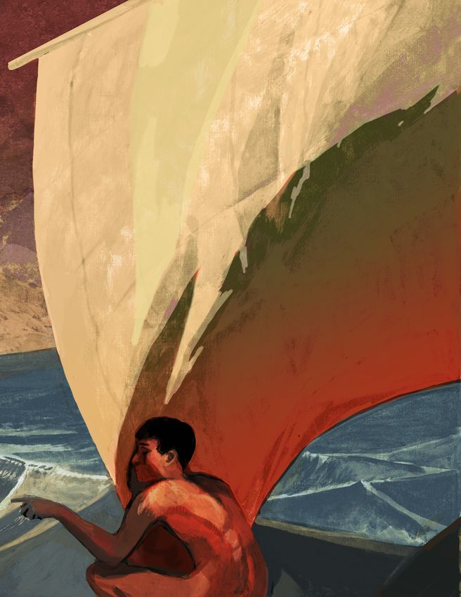
On the cover: Urbanization of Mediterranean Europe powered by sails, by Kelvin Wilson.
Cover design by Dora Kemp and Ben Plumridge.
Typesetting and layout by Ben Plumridge.
Edited for the Institute by Cyprian Broodbank (Acting Series Editor).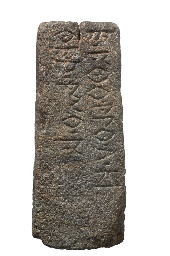
Contents
Contributorsix
Figuresxiii
Tablesxvii

Chapter 1   Making cities: economies of production and urbanization in Mediterranean Europe,
            1000–500 bc1
           Bela Dimova, Margarita Gleba & Beatriz Marín-Aguilera
      Definitions of urbanism                                                                         2
      Urbanism and textiles                                                                           2
      Contributions to this volume                                                                    3
      Cover illustration                                                                              4

Part I       Eastern Mediterranean
Chapter 2   Argilos: the booming economy of a silent city                                                  9
            Jacques Perreault & Zisis Bonias

Chapter 3   Regional economies and productions in the Thermaic Gulf area                                  21
           Despoina Tsiafaki
      Thermaic Gulf economies and production                                                         22
      Ancient Therme and its harbour                                                                 26
      Conclusion                                                                                     34

Chapter 4   Production activities and consumption of textiles in Early Iron Age Eretria                   39
            Karl Reber
      Eretria in the Early Iron Age                                                                  39
      Eretria’s economic situation                                                                   41
      The production and consumption of textiles                                                     41
      Conclusion                                                                                     45

Chapter 5   Productive economy and society at Zagora                                                      47
            Lesley A. Beaumont

Chapter 6   Making Cretan cities: urbanization, demography and economies of production in the
            Early Iron Age and the Archaic period                                                         57
           Antonis Kotsonas
      Urbanization                                                                                   58
      Demography                                                                                     66
      Economies of production                                                                        69
      Conclusion                                                                                     71

Chapter 7   Production, urbanization, and the rise of Athens in the Archaic period                        77
            Robin Osborne

Chapter 8   Making Corinth, 800–500 bc: production and consumption in Archaic Corinth                     89
            Ioulia Tzonou
      Eighth century, to the end of the Geometric period and the transition into the Early
           Protocorinthian, 720 bc95
      Seventh century, the Protocorinthian and Transitional period into Early Corinthian, 720–620 bc97
      Sixth century, the Corinthian period, 620–500 bc98
      Conclusion                                                                                    100

                                                        v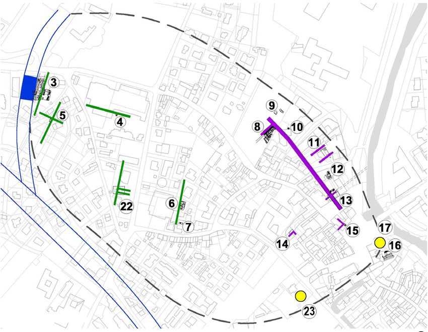
Part II      Central Mediterranean
Chapter 9   Making cities in Veneto between the tenth and the sixth century bc107
            Giovanna Gambacurta
      Urbanization criteria                                                                         107
      Landscape and population                                                                      109
      Settlements                                                                                   110
      Necropoleis                                                                                   111
      Borders and shrines                                                                           112
      Inscriptions                                                                                  114
      Myths                                                                                         115
      Conclusion                                                                                    116

Chapter 10 Attached versus independent craft production in the formation of the early city-state
           of Padova (northeastern Italy, first millennium bc)123
            Massimo Vidale & Paolo Michelini
      Materials and methods                                                                         124
      General patterns of industrial location                                                       126
      Methodological issues                                                                         128
      The craft industries through time                                                             130
      New craft locations: size and size variations through time                                    131
      Duration of urban craft workshops                                                             132
      Ceramic, copper and iron processing sites: size versus duration of activities                 133
      Discussion                                                                                    134
      A historical reconstruction                                                                   138
      Onset of proto-currency and the issue of remuneration                                         141
      Conclusion                                                                                    142

Chapter 11 Resource and ritual: manufacturing and production at Poggio Civitate                       147
            Anthony Tuck

Chapter 12 Perugia: the frontier city                                                                 161
            Letizia Ceccarelli & Simon Stoddart
      Geology and culture                                                                           161
      History of research                                                                           163
      The emerging city from the rural landscape                                                    165
      The topographical development of the city                                                     166
      The city and its hinterland                                                                   168
      The rural settlements associated with the city                                                169
      Conclusion                                                                                    172

Chapter 13 Tarquinia: themes of urbanization on the Civita and the Monterozzi Plateaus                177
            Giovanna Bagnasco Gianni, Matilde Marzullo & Claudia Piazzi
      Approaching themes of urbanization at Tarquinia                                               177
      On the positioning of the protostoric site of Calvario and its road links                     178
      The Calvario village on the Monterozzi Plateau and its economic activities during the eighth
          century bc                                                                                180
      The process of urbanization based on the evidence for the fortifications                      185
      The limits of Tarquinia before its fortification, a theoretical approach                      188

Chapter 14 Prolegomena to the material culture of Vulci during the Orientalizing period in the
           light of new discoveries                                                                   195
           Simona Carosi & Carlo Regoli
      New data from Poggio Mengarelli Necropolis                                                    195
      Conclusion                                                                                    202

                                                            vi
Making cities: economies of production and urbanization in Mediterranean Europe, 1000–500 bc

Chapter 15 Defining space, making the city: urbanism in Archaic Rome                                   205
            Jeffrey A. Becker
      Making civic space – the Forum Romanum and its environs                                        206
      Monumentality                                                                                  210
      Peri-urban evidence                                                                            211
      Discussion                                                                                     214

Chapter 16 Commodities, the instability of the gift, and the codification of cultural encounters
           in Archaic southern Etruria                                                                 219
           Corinna Riva
      Agricultural surplus and a new funerary ideology                                               220
      Oversize vessels and fixing the gift                                                           221
      Codification in the encounter                                                                  222
      Conclusion                                                                                     226

Chapter 17 The Etruscan pithos revolution                                                              231
            Phil Perkins
      The pithos as artefact                                                                         232
      Making pithoi                                                                                  236
      Using pithoi                                                                                   240
      Socio-economic agency of pithoi                                                                243
      Pithoi, economic development, and inequality                                                   245
      Pithoi, economic growth and cities                                                             248
      Conclusion                                                                                     250

Chapter 18 Birth and transformation of a Messapian settlement from the Iron Age to the Classical
           period: Muro Leccese                                                                        259
            Francesco Meo
      The Iron Age village                                                                           259
      The Archaic and Classical settlement                                                           266
      The Hellenistic period and the end of the town                                                 276

Chapter 19 Indigenous urbanism in Iron Age western Sicily                                              281
            Michael J. Kolb & William M. Balco
      Settlement layout                                                                              282
      Demographic changes                                                                            286
      Production, consumption and exchange                                                           288
      Ritual and cultic activity                                                                     290
      Conclusion                                                                                     291

Part III     Western Mediterranean
Chapter 20 Colonial production and urbanization in Iron Age to early Punic Sardinia
           (eighth–fifth century bc)299
           Andrea Roppa & Emanuele Madrigali
      Colonial production and amphora distribution in Iron Age Sardinia                              299
      Case studies: Nora and S’Urachi                                                                301
      Discussion                                                                                     305
      Colonial economies and urbanization                                                            309

Chapter 21 Entanglements and the elusive transfer of technological know-how, 1000–700 bc:
           elite prerogatives and migratory swallows in the western Mediterranean                      313
            Albert J. Nijboer
      Movement of peoples and goods                                                                  314
      Iron                                                                                           316
      The alphabet                                                                                   319
      Early monumental architecture                                                                  321
      Discussion and epilogue                                                                        323

                                                          vii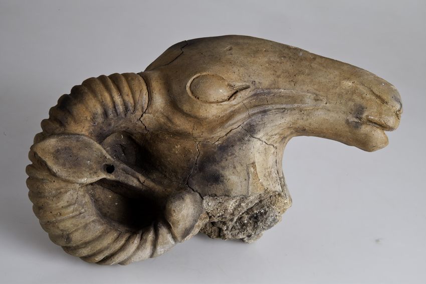
Chapter 1

Chapter 22 Making cities, producing textiles: the Late Hallstatt Fürstensitze329
            Manuel Fernández-Götz & Karina Grömer
      Monumentality, production and consumption: the settlement evidence                                      330
      Textile use and display in funerary contexts                                                            336
      Conclusion                                                                                              340

Chapter 23 From household to cities: habitats and societies in southern France during the Early Iron Age        345
            Éric Gailledrat
      A question of time                                                                                      346
      A contrasted image                                                                                      347
      From one Mediterranean to another                                                                       348
      The evanescent settlement                                                                               349
      The emergence of the fortified group settlement                                                         351
      The oppida of the sixth–fifth centuries bc                                                              354
      The house in the context of the group settlement                                                        358
      Craftspeople, crafts and workshops                                                                      361
      Conclusion                                                                                              363

Chapter 24 Urbanization and early state formation: elite control over manufacture in Iberia
           (seventh to third century bc)                                                                        367
            Joan Sanmartí, David Asensio & Rafel Jornet
      The historical process                                                                                  367
      Craft in its social context                                                                             369
      Conclusion                                                                                              380

Chapter 25 Productive power during the Early Iron Age (c. 650–575 bc) at the Sant Jaume Complex
           (Alcanar, Catalonia, Spain)                                                                          385
           Laura Álvarez, Mariona Arnó, Jorge A. Botero, Laia Font, David Garcia i Rubert,
           Marta Mateu, Margarita Rodés, Maria Tortras, Carme Saorin & Ana Serrano
      The Sant Jaume Complex                                                                                  385
      Production in the Sant Jaume Complex chiefdom                                                           388
      Conclusion                                                                                              392

Chapter 26 Not all that glitters is gold: urbanism and craftspeople in non-class or non-state run societies     395
            Marisa Ruiz-Gálvez
      Craftspeople and workshops in Iberia                                                                    395
      Workshops in Iberia                                                                                     398
      The Iberians as a House Society                                                                         400
      Conclusion                                                                                              404

Chapter 27 Urbanization and social change in southeast Iberia during the Early Iron Age                         409
            Jaime Vives-Ferrándiz Sánchez
      Iberian urbanization: connectivity and dispersed territories                                            409
      Local economies into broader networks                                                                   411
      Agricultural intensification                                                                            412
      Urbanization, institutions and political authority                                                      415
      Conclusion                                                                                              420

Chapter 28 ‘Building palaces in Spain’: rural economy and cities in post-Orientalizing Extremadura              425
            Javier Jiménez Ávila
      Cancho Roano as a phenomenon                                                                            429
      The ‘post-Orientalizing’ world                                                                          432
      Post-Orientalizing economies                                                                            432
      Countryside and cities                                                                                  438
      Final remarks                                                                                           440

Part IV     Conclusion
Chapter 29 Craft and the urban community: industriousness and socio-economic development                        447
            Christopher Smith

                                                           viii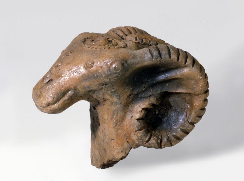
Contributors
David Alensio                                              Letizia Ceccarelli
Departament de Prehistòria, Història Antiga                Department of Chemistry, Materials and Chemical
i Arqueologia, Universitat de Barcelona, C/                Engineering ‘G.Natta’, Politecnico di Milano, Piazza
Montalegre 6-8, 08001 Barcelona, Spain                     Leonardo da Vinci 32, 20133 Milano, Italy
Email: davidasensio@ub.edu                                 Email: letizia.ceccarelli@polimi.it

Laura Álvarez Estapé                                       Bela Dimova
Independent scholar                                        British School at Athens, Souidias 52, Athens 10676,
Email: laura.alvarezestape@gmail.com                       Greece
                                                           Email: bela.dimova@bsa.ac.uk
Giovanna Bagnasco Gianni
Dipartimento di Beni Culturali e Ambientali,               Manuel Fernández-Götz
Università degli Studi di Milano, via Festa del            School of History, Classics and Archaeology,
Perdono 7, 20122 Milano, Italy                             University of Edinburgh, William Robertson Wing,
Email: giovanna.bagnasco@unimi.it                          Old Medical School, Teviot Place, Edinburgh,
                                                           EH8 9AG, UK
William Balco                                              Email: M.Fernandez-Gotz@ed.ac.uk
Department of History, Anthropology, and
Philosophy, University of North Georgia, Barnes            Eric Gailledrat
Hall 327, Dahlonega, GA 30597, USA                         CNRS, Archéologie des Sociétés Méditerranéennes,
Email: william.balco@ung.edu                               UMR 5140, Université Paul Valéry-Montpellier 3,
                                                           F-34199, Montpellier cedex 5, France
Lesley Beaumont                                            Email: eric.gailledrat@cnrs.fr
Department of Archaeology, Faculty of Arts & Social
Sciences, The University of Sydney, A18, Sydney,           Giovanna Gambacurta
NSW 2006, Australia                                        Dipartimento di Studi Umanistici, Università Ca’
Email: lesley.beaumont@sydney.edu.au                       Foscari Venezia, Palazzo Malcanton Marcorà,
                                                           Dorsoduro 3484/D, 30123 Venezia, Italy
Jeffrey Becker                                             Email: giovanna.gambacurta@unive.it
Department of Middle Eastern and Ancient
Mediterranean Studies, Binghamton University –             David Garcia I Rubert
State University of New York, 4400 Vestal Parkway          Departament de Prehistòria, Història Antiga i
East, PO Box 6000, Binghamton, NY 13902-6000,              Arqueologia, Universitat de Barcelona, Carrer
USA                                                        Montalegre 6, 08001 Barcelona, Spain
Email: beckerj@binghamton.edu                              Email: dgarciar@ub.edu

Zisis Bonias                                               Margarita Gleba
Ephorate of Antiquities of Kavala-Thasos, Erythrou         Dipartimento dei Beni Culturali, Università degli
Stavrou 17, Kavala 65110, Greece                           Studi di Padova, Piazza Capitaniato 7, Palazzo
Email: zbonias@yahoo.gr                                    Liviano, 35139 Padova, Italy
                                                           Email: margarita.gleba@unipd.it
Simona Carosi
Soprintendenza Archeologia Belle Arti e Paesaggio          Karina Grömer
per l’area metropolitana di Roma, la provincia di          Natural History Museum Vienna, Department of
Viterbo e l’Etruria meridionale, Palazzo Patrizi           Prehistory, Burgring 7, 1010 Vienna, Austria
Clementi, via Cavalletti n.2, 00186 Roma, Italy            Email: karina.groemer@nhm-wien.ac.at
Email: simona.carosi@beniculturali.it

                                                      ix
Javier Jiménez Ávila Albert Nijboer
Consejería de Cultura, Turismo y Deporte – Junta Groningen Institute of Archaeology, Poststraat 6,
de Extremadura, Edificio Tercer Milenio, Módulo 4, 9712 ER Groningen, The Netherlands
Avda. de Valhondo s/n, 06800 Mérida, Spain Email: a.j.nijboer@rug.nl
Email: jjimavila@hotmail.com
Robin Osborne
Rafel Journet University of Cambridge, Faculty of Classics,
Departament de Prehistòria, Història Antiga Sidgwick Avenue, Cambridge CB3 9DA, UK
i Arqueologia, Universitat de Barcelona, C/ Email: ro225@cam.ac.uk
Montalegre 6-8, 08001 Barcelona, Spain
Email: rafeljornet@ub.edu Phil Perkins
Classical Studies, School of Arts & Humanities,
Michael Kolb The Open University, Perry C Second Floor, 25,
Department of Sociology and Anthropology, Walton Hall, Milton Keynes MK7 6AA, UK
Metropolitan State University of Denver, Campus Email: Phil.Perkins@open.ac.uk
Box 19, P.O. Box 173362, Denver, CO 80217-3362,
USA Jacques Perreault
Email: mkolb5@msudenver.edu Université de Montréal C.P. 6128, Succursale
Centre-Ville Montréal, QC, H3C 3J7, Canada
Antonis Kotsonas Email: jacques.y.perreault@umontreal.ca
Institute for the Study of the Ancient World, New
York University, 15 East 84th St., New York, NY Claudia Piazzi
10028, USA Coordinating Research Centre ‘Tarquinia Project’,
Email: ak7509@nyu.edu Dipartimento di Beni Culturali e Ambientali,
Università degli Studi di Milano, via Festa del
Emanuele Madrigali Perdono 7, 20122 Milano, Italy
Independent scholar Email: claudia.piazzi2@gmail.com
Email: e.madrigali@gmail.com
Karl Reber
Beatriz Marín-Aguilera Université de Lausanne, Anthropole 4011, 1015
McDonald Institute for Archaeological Research, Lausanne, Switzerland
University of Cambridge, Downing Street, Email: karl.reber@unil.ch
Cambridge CB2 3DZ, UK
Email: bm499@cam.ac.uk Carlo Regoli
Fondazione Vulci, Parco Naturalistico Archeologico
Matilde Marzullo di Vulci, 01014 Montalto di Castro (Viterbo), Italy
Coordinating Research Centre ‘Tarquinia Project’, Email: caregoli@gmail.com
Dipartimento di Beni Culturali e Ambientali,
Università degli Studi di Milano, via Festa del Corinna Riva
Perdono 7, 20122 Milano, Italy Institute of Archaeology, University College
Email: matilde.marzullo@unimi.it London, 31–34 Gordon Square, London
WC1H 0PY, UK
Francesco Meo Email: c.riva@ucl.ac.uk
Dipartimento di Beni Culturali, Università del
Salento, Via D. Birago, 64, 73100 Lecce, Italy Andrea Roppa
Email: francesco.meo@unisalento.it Independent scholar
Email: roppaandrea@gmail.com
Paolo Michelini
P.ET.R.A., Società Cooperativa ARL, Via Matera, 7 Marisa Ruiz-Gálvez
a/b, 35143 Padova, Italy Departamento de Prehistoria, Historia Antigua y
Email: paolo.mik@libero.it Arqueología, Universidad Complutense de Madrid,
Edificio B C/ Profesor Aranguren, s/n Ciudad
Universitaria, 28040 Madrid, Spain
Email: marisar.gp@ghis.ucm.es
xJoan Sanmartí Grego Anthony Tuck
Departament de Prehistòria, Història Antiga i Department of Classics, University of Massachusetts
Arqueologia, Universitat de Barcelona, Carrer Amherst, 524 Herter Hall, 161 Presidents Drive
Montalegre 6, 08001 Barcelona, Spain Amherst, MA 01003, USA
Email: sanmarti@ub.edu Email: atuck@classics.umass.edu
Christopher Smith Ioulia Tzonou
School of Classics, University of St Andrews, Fife Corinth Excavations, American School of Classical
KY16 9AL, UK Studies at Athens, Ancient Corinth 20007, Greece
Email: cjs6@st-and.ac.uk Email: itzonou.corinth@ascsa.edu.gr
Simon Stoddart Massimo Vidale
Department of Archaeology, University of Dipartimento dei Beni Culturali, Università degli
Cambridge, Downing Street, Cambridge Studi di Padova, Piazza Capitaniato 7, Palazzo
CB2 3DZ, UK Liviano, 35139 Padova, Italy
Email: ss16@cam.ac.uk Email: massimo.vidale@unipd.it
Despoina Tsiafaki Jaime Vives-Ferrándiz Sanchez
Culture & Creative Industries Department, ‘Athena’: Museu de Prehistòria de València
Research & Innovation Center in Information, Email: jaime.vivesferrandiz@dival.es
Communication & Knowledge Technologies.
Building of ‘Athena’ R.C., University Campus of
Kimmeria, P.O. Box 159, Xanthi 67100, Greece
Email: tsiafaki@ipet.gr
xiFigures
1.1 Map indicating the volume coverage. 4
2.1 Argilos, aerial view.
10
2.2 Argilos, general plan. 10
2.3 Small furnace in building E. 11
2.4 View of building L.
12
2.5 Plan of Koutloudis area with buildings H, L, P, and Q. 13
2.6 Building L, press-bed in room 4. 13
2.7 Building Q, room 1. 14
2.8 Building L, room 11, crushed amphorae. 16
2.9 Dividing wall between L7–L8 with remains of clay over the lower courses of stone. 17
2.10 Building L, facades of L2–L3. 18
3.1 Thermaic Gulf region. 22
3.2 Iron sword, grave offering, Nea Philadelphia cemetery, late sixth century bc. 24
3.3 Miniature iron wagon, grave offering, Sindos cemetery, late sixth century bc. 25
3.4 Methone. Pottery kilns in Building A at Sector B. 26
3.5 Ancient settlement at Karabournaki, aerial view. 27
3.6 Ancient settlement at Karabournaki, storeroom with pithoi. 28
3.7 ‘Eggshell’ type vases made at the pottery workshop at Karabournaki. 29
3.8 Karabournaki settlement metal workshop. 30
3.9 Weaving tools from the Karabournaki settlement. 31
3.10 Loom weight with stamp depicting a satyr, Karabournaki settlement. 32
3.11 Karabournaki: distribution of textile production tools within the excavated area.
33
4.1 Map of Geometric Eretria. 40
4.2 Plan of the Sanctuary of Apollo in the eighth century bc. 40
4.3 Spindle whorl with dedication, from the Sanctuary of Apollo. 42
4.4 Cruche à haut col C41 (tankard) from the Aire sacrificielle. 42
4.5 Cruche à haut col C37 (tankard) from the Aire sacrificielle. 43
4.6 Fragment of linen from Grave 10 in the Heroon Necropolis. 44
4.7 Close-ups of wool weft-faced textiles from the Heroon Necropolis. 45
5.1 View of Zagora promontory from the northeast. 48
5.2 Plan of Zagora. 49
5.3 Aerial view of Trench 11, partially excavated.
52
6.1 Map of Crete showing sites mentioned in the text. 58
6.2 Plan of Karphi. 59
6.3 Plan of the Knossos valley. 62
6.4 Plan of Prinias. 64
6.5 Plan of Azoria. 65
6.6 Knossos North Cemetery: maximum and minimum number of cremation urns over time. 68
6.7 Knossos North Cemetery: number of cremation urns per year. 68
6.8 Fortetsa Cemetery: number of burials over time. 68
6.9 Fortetsa Cemetery: number of burials per year. 68
6.10 Reconstruction of the pottery workshop at Mandra di Gipari, near Prinias. 70
7.1 Attica, 1050–900 bc. 80
7.2 Attica, 900–800 bc. 80
7.3 Attica, 800–700 bc. 81
7.4 Attica, 700–600 bc. 81
7.5 Attica, 600–500 bc. 85
8.1 Map of the northeast Peloponnese showing sites mentioned in the text. 90
8.2 Corinth: Geometric Period multiphase plan (900–720 bc). 91
8.3 Corinth: Protocorinthian to Transitional Period multiphase plan (720–620 bc). 91
8.4 Corinth: Corinthian Period multiphase plan (620–500 bc). 92
8.5 Corinth: fifth century bc multiphase plan. 93
xiii8.6 Corinth: multiphase plan up to 400 bc. 93
8.7 Corinth: Forum, all periods. 94
8.8 South Stoa, Tavern of Aphrodite Foundry. 99
8.9 Late Corinthian kraters from the sixth-century bc floor. 101
8.10 The Arachne aryballos, Late Early Corinthian or Middle Corinthian (600 bc). 102
9.1 Maps of Veneto. 108
9.2 Maps of cities with different orientations: a) Oderzo; b) Padova. 110
9.3 Este, clay andirons with ram’s heads. 112
9.4 Padova, funerary stone monuments: a) Camin; b) Albignasego. 112
9.5 Padova, via Tadi, boundary stone with Venetic inscription on two sides. 114
9.6 Padova, via C. Battisti, boundary stone with Venetic inscription on four sides. 114
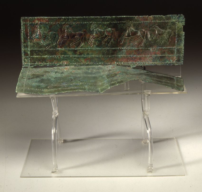
9.7 Padova, via Tiepolo–via San Massimo 1991, Grave 159, bronze figured belt-hook. 115
9.8 Este, Casa di Ricovero, Grave 23/1993 or Nerka’s grave. 116
9.9 Isola Vicentina, stele with Venetic inscription. 117
10.1 Location of Padova and the study area in northeastern Italy. 124
10.2 Padova, general cumulative map of the craft locations, c. 825–50 bc. 125
10.3 Padova, location of the craft areas and workshops in the early urban core. 127
10.4 Padova, the extra-urban location of craft industries in Roman times. 129
10.5 New manufacturing areas per different craft. 131
10.6 Maximum total area occupied by craft production sites. 132
10.7 New craft areas activated in each period. 132
10.8 Frequency distribution of dimensional class of craft areas per period.
132
10.9 Padova, Questura, site 2, northeast sector. 133
10.10 Workshop size and duration of activity. 134
10.11 Padova, Questura, site 2. Ceramic tuyère. 136
10.12 Padova, Questura, site 2. Cluster of fine feasting pottery. 137
10.13 Padova, Questura, site 2. Antler combs from the metallurgical workshop. 137
10.14 Sherds of Attic pottery from workshop areas in Padova. 138
10.15 Padova, Piazza Castello, site 3: vertical kiln and modular perforated grid. 139
10.16 Part of an elite grave’s furnishings from Padova, end of the eighth century bc. 140
10.17 Vessels from the cemetery of Piovego, Padova, fifth century bc. 141
11.1 Map of central Italy. 148
11.2 Early Phase Orientalizing Complex Building 4 (c. 725–675 bc) reconstruction. 148
11.3 Orientalizing Complex (c. 675–600 bc) reconstruction. 149
11.4 Archaic Phase Structure (c. 600–530 bc) reconstruction. 149
11.5 Orientalizing Complex roofing elements. 150
11.6 Partially worked and complete bone, antler and ivory. 150
11.7 Unfired cover tiles with human footprints. 151
11.8 Distribution of variable sized spindle whorls. 152
11.9 Carbonized seeds from Orientalizing Complex Building 2/Workshop. 153
11.10 Fragment of statuette from Orientalizing Complex Building 2/Workshop. 153
11.11 Frieze plaque depicting banqueting scene, Archaic Phase Structure. 155
11.12 Elements of a banquet service from the Orientalizing Complex. 155
11.13 Compote with incised khi. 156
11.14 Map of Poggio Civitate and surrounding traces of settlements or other human activity.
157
12.1 Location of Perugia. 162
12.2 The immediate environs of Perugia with key sites. 162
12.3 The geological context of Perugia. 163
12.4 Plan of the city of Perugia. 166
12.5 Hierarchical relationship of Perugia to its territory. 169
12.6 Civitella d’Arna survey area. 171
12.7 Montelabate survey area. 172
13.1 Positioning of the structures of the Calvario. 179
13.2 Tarquinia and its territory around the middle of the eighth century bc. 180
xiv13.3 Plan of the Villanovan village on the Monterozzi Plateau. 181
13.4 Plans of some of the Villanovan huts. 183
13.5 Finds from the huts. 184
13.6 Walls, gateways and roads of ancient Tarquinia. 185
13.7 Tarquinia, Bocchoris Tomb, lid. 189
14.1 Location of the excavation area at Vulci. 196
14.2 Aerial photograph of the excavation (2016–2018). 197
14.3 General plan of the excavation (2016–2018). 197
14.4 Textile fragment from the ‘Tomb of the Golden Scarab’. 198
14.5 Detail of the grave goods from Tomb 35 during excavation. 199
14.6 Tomb 29 during excavation. 200
14.7 Tomb 29: detail of the traces of cloth on the lid of the sheet bronze stamnos. 201
14.8 Tomb 72: a textile with colour pattern of small red and white checks. 202
15.1 Plan of Rome’s territory in the Archaic period. 206
15.2 Area of the Volcanal and the Comitium in the seventh and sixth centuries bc. 207
15.3 Reconstructed plan of Rome within the so-called ‘Servian Wall’. 208
15.4 Sketch plan of the area of the Forum Boarium and Velabrum in the seventh century bc. 210
15.5 Phase 1 of the so-called ‘Auditorium site’ villa. 212
15.6 Phase 2 of the so-called ‘Auditorium site’ villa. 212
15.7 The Republican ‘Villa delle Grotte’ at Grottarossa. 213
16.1 White-on-red pithos with lid, Cerveteri. 223
16.2 Figurative decoration of the Gobbi krater. 224
16.3 Black-figure amphora, Vulci, side A. 226
16.4 Black-figure amphora, Vulci, side B. 226
17.1 Pithos types 1–6. 233
17.2 Distribution map of Etruscan pithoi within the study area in Etruria. 240
17.3 Comparison between the altitude of pithos find spots and the range of altitude. 241
17.4 Map of sample area. 242
17.5 Distribution of architectural terracottas, pithoi, amphorae, and tiles. 249
18.1 Muro Leccese and the other Iron Age settlements in the Salento peninsula. 260
18.2 Muro Leccese, find spots of Early Iron Age and Archaic ceramics and structures. 261
18.3 Muro Leccese, Cunella district, traces of two huts. 262
18.4 Muro Leccese, DTM with location of the Iron Age ceramics and structures. 263
18.5 Vases and decorative motifs characteristic of matt-painted ware from Muro Leccese. 264
18.6 Vases imported from Greece and Greek apoikiai. 265
18.7 The Messapian era road network in the Salento peninsula. 267
18.8 Muro Leccese, Palombara district. 268
18.9 Muro Leccese, Palombara district. Vases. 270
18.10 Muro Leccese, Cunella district. Plan of the residential building. 272
18.11 Diorama of the place of worship in the archaeological area of Cunella. 273
18.12 Muro Leccese, Masseria Cunella district. Tombs 1 and 2. 274
18.13 Muro Leccese, fourth century bc walls. 275
19.1 Map of Sicily, showing the Bronze Age sites mentioned in the text. 282
19.2 The defensive wall at Bronze Age site of Mursia, Pantelleria. 283
19.3 The Late Bronze Age excavations at Mokarta. 283
19.4 Monte Bonifato, showing its steep approaches. 284
19.5 Map of western Sicily showing the Iron Age sites mentioned in the text. 284
19.6 The urban layout of Eryx. 285
19.7 The urban layout of Segesta. 286
19.8 The orthogonal grid and Iron Age/Classical/Hellenistic finds of Salemi. 287
19.9 The archaeological sites of Salemi territory. 287
19.10 The temple of Segesta, facing west. 291
20.1 Map of Sardinia showing sites mentioned in the text. 300
20.2 Plan of Nora and the Punic quarter under the forum. 301
xv20.3 Main amphora types discussed. 302
20.4 Dating profiles of amphora types. 303
20.5 Plan of nuraghe S’Urachi and cross-section of the ditch in area E. 304
20.6 Dating profile of the amphora types from the case study at nuraghe S’Urachi. 305
20.7 Dating profiles of Phoenician amphora types. 306
21.1 Early iron and the distribution of Huelva-Achziv type fibulae on the Iberian Peninsula. 317
21.2 Three copper alloy bowls dated to the decades around 800 bc. 319
21.3 The Phoenician, Euboean, Etruscan and Latin alphabetic letters. 320
21.4 Early monumental architecture in Italy and Spain. 322
21.5 Provenance of ceramics from the ninth century bc, pre-Carthage Utica (Tunis). 324
22.1 Fürstensitze north of the Alps and selected sites in Mediterranean Europe. 330
22.2 The Heuneburg agglomeration during the mudbrick wall phase. 331
22.3 Indicative lifespans of selected Fürstensitze sites. 331
22.4 Aerial view of the gatehouse of the Heuneburg lower town during the excavation. 332
22.5 Large ditch at the south foot of wall 3 at Mont Lassois.
333
22.6 Reconstructed monumental building in the Heuneburg Open-Air Museum. 334
22.7 Fired clay loom weight and spindle whorls from the Heuneburg. 335
22.8 Comparison between grave textiles and other textiles. 337
22.9 Tablet-woven band, reproduced after a textile from Hochdorf. 338
22.10 Functions of textiles in graves. 339
23.1 Map of the south of France showing the main settlements of the Early Iron Age. 346
23.2 Mailhac (Aude). 350
23.3 Examples of apsidal floorplans of wattle-and-daub (a) or cob houses (b–d). 352
23.4 Examples of rectangular floorplans of houses with one or more rooms. 353
23.5 Pech Maho (Sigean, Aude). 355
23.6 Examples of functional combinations of apsidal and rectangular floorplans. 356
23.7 Early examples of urban planning combining blocks of houses with a system of streets. 357
23.8 a–c) Examples of rectangular floorplans; d–e) houses of La Liquière. 359
23.9 Montlaurès (Narbonne, Aude). 360
24.1 Map of northern Iberia showing the sites mentioned in the text. 368
24.2 Pottery workshop of Hortes de Cal Pons. 371
24.3 Bases of Iberian amphorae. 372
24.4 Les Guàrdies (El Vendrell). 373
24.5 Castellet de Banyoles. 375
24.6 Mas Castellar de Pontós. 376
24.7 Coll del Moro de Gandesa. 378
24.8 Sant Antoni de Calaceit. 379
24.9 Els Estinclells.
380
25.1 General location of the area under study. 386
25.2 View of Sant Jaume. 387
25.3 Plan of Sant Jaume. 387
25.4 Aerial view of La Moleta del Remei. 389
25.5 Aerial view of La Ferradura. 389
26.1 Tumulus ‘A’ at Setefilla. 396
26.2 Sample of matrices and tools from the so-called goldsmith’s graves at Cabezo Lucero. 397
26.3 Iberian tombs with grave goods connected with weighing metal. 398
26.4 Spatial distribution of tools in rooms of Iberian oppida. 400
26.5 Iberian funerary pillars crowned by heraldic beasts. 402
26.6 Enthroned Iberian ladies: a) Cerro de los Santos; b) Baza. 403
26.7 Reconstructions: a) La Bastida de les Alcusses; b) El Castellet de Banyoles. 403
26.8 Bronze horseman from La Bastida de Les Alcusses and reconstruction as a sceptre. 404
27.1 Map of the study area showing the main sites mentioned in the text. 410
27.2 Metallurgical workshop at La Fonteta. 412
27.3 Plan of Alt de Benimaquia and local amphorae. 413
xvi27.4 Plan of El Oral. 414
27.5 The territory of El Puig d’Alcoi and the secondary rural settlements. 416
27.6 Different furnaces for iron metalwork from La Cervera. 416
27.7 Plans of walled settlements: a) Covalta; b) Puig d’Alcoi; c) La Bastida de les Alcusses. 417
27.8 Aerial view of the storerooms at La Bastida de les Alcusses. 418
27.9 Plan of Block 5 at La Bastida de les Alcusses. 419
27.10 Weapons ritually ‘killed’ in the West Gate, La Bastida de les Alcusses. 419
28.1 Cancho Roano: a) general plan; b–c) reconstructions of the external rooms. 426
28.2 Map of sites considered as post-Orientalizing palatial complexes. 427
28.3 La Mata. 428
28.4 Post-Orientalizing settlements: a,d) El Chaparral; b) La Carbonera; c) Los Caños. 431
28.5 Millstones and amphorae from post-Orientalizing sites in Middle Guadiana. 433
28.6 Storage building at the Orientalizing site of El Palomar, Oliva de Mérida. 434
28.7 Greek pottery from Cancho Roano, late fifth century bc. 436
28.8 Antique (sixth-century bc) goods in post-Orientalizing contexts. 437
28.9 The Orientalizing site of Medellín. 439
28.10 Ancient toponymy in southwestern Iberia. 440
Tables
7.1 Sites in Attica, late eleventh to seventh century bc. 78
8.1 Dates: abbreviations and chronology. 90
9.1 List of criteria for defining cities.
108
9.2 Inventory of houses and buildings with their shape, dimensions and chronology. 111
10.1 Variations through time of principal type of craft occupation. 128
10.2 Variations through time of the maximum area of all craft occupations. 129
10.3 Padova, average duration in years of the main craft occupations for each period. 129
10.4 Padova, the development of craft industries as monitored in 29 craft workshops. 130
10.5 Positive correlation between size and duration of activity of craft workshops. 134
10.6 The composition of funerary vessels in the earliest graves from Padova. 140
14.1 Types of tombs excavated at Poggio Mengarelli, Vulci (2016–2018). 196
17.1 Type 1. 234
17.2 Type 2. 234
17.3 Type 3. 235
17.4 Type 3A. 235
17.5 Type 3B. 235
17.6 Type 3C. 236
17.7 Type 4. 236
17.8 Type 5. 237
17.9 Type 6. 237
17.10 Chaîne opératoire of Etruscan pithos manufacture. 238
21.1 Number of iron artefacts per phase at Torre Galli (c. 950–850 bc). 318
xviiChapter 9
Making cities in Veneto
between the tenth and the sixth century bc
Giovanna Gambacurta
‘La première ville n’existe pas’ or ‘the first city does not Italy, where the first cities begin to develop from the
exist’ stated Corinne Castel, a Near Eastern archaeolo- ninth to the early eighth century bc, and continue to
gist, in a recent paper (Castel 2015). What she likely evolve over the course of at least two centuries. An
meant was that the survival, maintenance and improve- important question, therefore, pertains to what kind
ment of ancient cities was best facilitated if they were of features should we consider as ‘standard’, or indi-
linked together in a network. Thus, the archaeological cators of a settlement being a city. After establishing
scientific community should conceptualize the begin- what features constitute a city, several other matters
nings of urbanism as a plurality of ‘first cities,’ rather remain without a clear answer. For example, was the
than just a single ‘first city’. This issue has been studied city an intentional or accidental creation? How many
in detail since the 1980s, mostly by scholars of the Near people lived in the city? What was life like in cities?
East (Castel 2015). What was the physical health of the residents of cities,
Archaeologists specializing in prehistoric and e.g. did city life contribute to the spread of epidem-
protohistoric periods have also focused attention on ics? How were social relationships affected by life in
the relationship between the city and polity and the the city? These and other questions remain for future
rise of the state. In addition, we can list significant research (Cowgill 2004; Caliò 2009).
contributions about the concepts of the city itself, For these reasons, it is essential to define the cri-
including the opposition between city and countryside, teria that we consider relevant to describe a city and to
or city and countryside villages.1 Before exploring the emphasize that no single one of these criteria should
urbanization of northern Italy, particularly the evidence be considered alone, or as the most important; rather,
from the Veneto region, it is necessary to investigate that all of the attributes defining cities work together
the specific contexts (landscape, sources, routes, etc.) (Cowgill 2004, 526–8).
in which the first city as an institution appeared, to
define the concept of ‘city’, and to determine which Urbanization criteria
kind of city we are trying to describe.
The concept of the city as defined by archae- As Carmine Ampolo (1988, 54) emphasized, drawing
ologists is not the same as that used by urbanists, on Thucydides’ and Rousseau’s concepts, ‘only the
historians, sociologists and researchers in other dis- citizens make the city,’ and the city is a centripetal phe-
ciplines. Beyond commonplace assumptions and nomenon that is strongly connected with the private
stereotypes, we must be very careful in our definition, ownership of the land (Thucydides, VII.77.7; also see
due to the fact that our point of view is always focused Colonna 1987, 15–6; Frisone 2019). Homer mentions
on archaeological realities (i.e. physical evidence), and four main actions necessary to create the city or the
we are almost always only able to investigate small polis: building walls, building houses for the citizens,
portions of ancient cities, usually less than five or ten building houses for the gods, and sharing fields for
per cent. agricultural activities (Hom. Od. VI.9–10: ‘ἀμφὶ δὲ
It has been established that, in Italy, the earliest τεῖχος ἔλασσε πόλει καὶ ἐδείματο οἴκους / καὶ νηοὺς
development of cities begins around 1000 bc, possibly ποίησε θεῶν καὶ ἐδάσσατ’ ἀρούρας’). Yet, even if
in Etruria (Pacciarelli 2001; see Bagnasco Gianni et al. in these criteria are true from a historical point of view,
this volume), about 100 years earlier than in northern what are their physical counterparts?
107Chapter 9
Table 9.1. List of criteria for defining cities. In this chapter, I collect some criteria and iden-
1. The landscape: geomorphology, natural sources, spatial tify them within a hierarchical system (Table 9.1),
dimensions and then attempt to verify whether these markers
2. Settlements: planimetry, houses and other buildings, are documented in Veneto. Some of these criteria
streets, districts have been noted before (cf. note 1), but they have not
3. Public places or monumental buildings been discussed as a coherent system with respect to
4. The arrangement of the cemeteries
Veneto, and not in a correct chronological perspec-
tive (e.g. Lomas 2007; 2017). The analysis is based on
5. Borders: structures and shrines
excavated data from the two most important cities,
6. Growing economy and transformation of value Este and Padova, considered Veneto’s ‘first cities’, as
7. Political, institutional and religious organizations well as smaller centres of Gazzo Veronese, Oppeano,
8. Writing knowledge Oderzo, Treviso, Altino and others (Fig. 9.1). I will
9. Army begin with the most concrete archaeological evidence,
followed by the discussion of indirect considerations
10. Ability and power to include foreigners
and new ideas, in order to understand the nature of
11. Tales and myths
the development of ancient Venetic cities.
a b
c
Figure 9.1. Veneto: a) tenth–ninth century bc; b) eighth–
seventh century bc; c) sixth-fifth century bc. Squares:
settlements which are going to disappear; dots: main
settlements and cities; triangles: new settlements or cities.
Big dots and the names only for main cities (modified
from Capuis & Gambacurta 2015, figs. 1–3).
108Making cities in Veneto between the tenth and the sixth century bc
Following the establishment of criteria to define Landscape and population
cities, we will first consider the landscape, the choice
of the settlement, followed by a consideration of the Before considering each urbanization characteristic, I
economic and natural resources. Then, we shall ana- will briefly discuss topographical features of the Veneto
lyse its design, including borders, streets, quarters region and its population dynamics. The morphology
and the intentional use of space as public or resi- of the landscape is very diverse, characterized by high
dential. In this perspective, a very important feature mountains in the north, followed by hills, and a large
of ancient cities is the presence of shrines as sacred plain crisscrossed by several rivers that overlooks the
places devoted to a divinity to satisfy the spiritual Venice lagoon and the Adriatic Sea. The most important
needs of the citizens. Additionally, another signifi- rivers in this region are the Po (the longest in Italy) in
cant aspect to consider is the existence of an entire the south, the Adige (the second longest in Italy), which
pantheon that provides a complex system of answers flowed 15 km further north than its current course,
to those spiritual needs. The evidence furthermore and the Piave in the east. The Po River and its valley
demonstrates that these cities quickly developed a link the southern Venetic area with northwestern and
complex organization, as reflected in their funerary central Italy, while the Adige and Piave Rivers allow
rituals and the arrangement of their cemeteries (see crossing the Alps towards central and eastern Europe.
Gambacurta 2020). When it comes to the population dynamics in
Summarizing, the criteria to be considered the Early Iron Age, it has been recently demonstrated
include: that numerous villages had collapsed in Veneto dur-
ing this period, mostly along the Po River and on the
1) The landscape; hills, similar to what happened in Etruria almost at
2) The settlement features; the same time (Capuis & Gambacurta 2015). It appears
3) Public places or monumental buildings; that, at the beginning of the eighth century bc, many
4) The arrangement of the necropoleis; small villages were quietly and peacefully abandoned,
5) Borders: structures and shrines. with evidence of people choosing new locations for
new settlements that became cities over a short period
No single feature is sufficient to make a city; but it of time (Calzavara Capuis et al. 1984; Capuis & Gam-
is important to evaluate them together, and also in bacurta 2015).
combination with other aspects that are frequently Meanwhile, an interesting phenomenon occurred
forgotten: in the region between the Po and Adige Rivers, result-
ing in social and economic changes. It has been well
6) A growing economy supported by the produc- established that this area was very important during
tion of surplus and exchange of goods, and the the Bronze Age for long-distance trade. For example,
transformation of their value, especially con- amber from the Baltic coast transited through here to
sidering consumers, farmers and entrepreneurs be exchanged on the Mediterranean markets, with
(Frankenstein & Rowlands 1978; Greco 1994, Frattesina di Fratta Polesine being one of the most
588–9; Cowgill 2004); important ports of trade in the Adriatic Sea (Cardarelli
7) The presence of political, institutional and reli- et al. 2015; Bietti Sestieri et al. 2015; 2019). Nonetheless,
gious organizations; after about two generations, Frattesina and all the ter-
8) The emergence of an army with a clear structure ritories near the Po River were abandoned at the end
(Greco 1994, 596–7; Cherici 1999); of the ninth–beginning of the eighth century bc and
9) The ability and power of the community to remained uninhabited until the early sixth century.
include foreigners; It is possible that the frontiers between the Venetic
10) The capacity of the citizens to develop stories people, carriers of the Villanovan culture, and the
and myths to support the way in which they Etruscans had been established along the Adige River
conceptualize their own narrative, reflecting (Capuis & Gambacurta 2015, 451). Therefore, people
understanding and knowledge of their world. who had lived in this area found themselves needing
11) The knowledge of alphabet and the ability to search for better places to start a new settlement,
to write are also relevant markers indicating which probably also had a new shape. In almost every
increasing urbanization. case, new settlements were built on elevated terraces
or small hills instead of the surrounding plains, and
Some of these features could be discussed further, from the outset locations with about 60–80 or 100 ha
using a combination of analysis of written sources were chosen (Capuis & Gambacurta 2015, 455, tab. 1).
from Classical writers and epigraphic inscriptions. It is also interesting to note that, in Veneto, almost all
109Chapter 9
a b Roads
Ditches
Wooden fences
Stone bank
0 400 m
N
0 100 m
Figure 9.2. Maps of cities with different orientations: a) Oderzo: two distinct districts; two yellow dots to the south
indicate two boundary stones; b) Padova: distinct districts in the centre and near the riverside.
of the settlements that would later become cities are these districts were oriented the same way, sometimes
situated near a river, which reflects Strabo’s famous they were oriented differently (Gambacurta & Groppo
quote about Venetic cities as isles, strictly connected 2016, 33, figs. 1–2). Between the end of the ninth and
with water (Strabo V.1.5; Pezzelle 2016, 168–8, 447, T. the seventh century bc, in Oppeano, Este, Padova and
39i; Capuis 1993, 69–76). Furthermore, Strabo describes Oderzo (Fig. 9.2), significant portions of districts with
the Venetic people as populating ‘fifty cities’, but a coherent orientation become apparent.2 Orientation
considering that he wrote between the first century bc could vary among the different districts, according to
and the first century ad, this could be an anachronistic the needs of local topography or other reasons. Thus,
exaggeration. Another source also emphasizes the the orientation could vary, for example, near the river
importance of Veneto in the ancient Mediterranean and along the banks.
world (ps.-Scymn., vv. 369–403; Pezzelle 2016, 412–3, Concerning the dimensions of the buildings,
T. 29b). the co-existence of houses of different sizes is quite
For central Italy, it has been demonstrated that notable. Between the ninth and seventh century bc,
cities were completely inhabited from the beginning, several settlements contain houses of small size, with
but not in an intensive way (Pacciarelli 2001, 11–14; just one room of about 35–45 sq. m; intermediate
115–16, with ample bibliographic references). There are size houses, about 75–100 sq. m with at least two
similar examples in Veneto, where the open plans of rooms, and rare large houses ranging from 150–200
the first houses have been observed. These areas were sq. m (Table 9.2) (Capuis & Gambacurta 2015, 456,
probably designed as gardens or areas for keeping tab. II). This wide differentiation of house dimensions
small animals (Gamba et al. 1990, 101–2; Capuis 1993, could be explained as a result of an establishment of
71–2). Therefore, it appears that these newly occupied a clear hierarchy among the buildings in relation to
sites were chosen to allow for expansion and rapid the increasing social hierarchy. For example, during
growth, probably representing a proto-urban phase the eighth century bc in Padova, houses of 32.5 sq. m
that likely had a variable duration and evolution in dif- were identified in the centre of the town, and houses
ferent centres (Pacciarelli 2001, 115–16; Castel 2015, 1). of 170–190 sq. m were documented in the southern
district (De Min et al. 2005, 80, figs. 88–89, 88, fig.
Settlements 100; see also Vidale & Michelini in this volume).
Interestingly, in Oderzo, small houses in the western
Rectangular or square houses, some with two different districts were in use at the same time as a very large
rooms, appear in Treviso from the tenth century bc building with a portico on its southern side located
onward (Bianchin 2004). However, it is only from the in the eastern district. This large building is con-
end of the ninth century bc that rectangular houses nected with a substantial, enigmatic ditch lined with
organized in a regular system of gridded roads with wooden walls and filled with about 300,000 fragments
defined districts appeared in Oderzo. Sometimes, of local and imported pottery, dating over the span
110Making cities in Veneto between the tenth and the sixth century bc
Table 9.2. Inventory of houses and buildings with their shape, dimensions and chronology (modified from Capuis & Gambacurta 2015, 456, tab. II).
City Shape No. of rooms Measures M. sq. Chronology
Treviso S.PioX 1 Rectangular 1 7.5 × 6 m 45 Late tenth–ninth centuries bc
Treviso S.PioX 2 Rectangular 2 15 × 7 m 105 Early ninth century bc
Oderzo, east quarter Stadio 1 Rectangular 2 17.5 × >9 m >157 Late tenth–ninth centuries bc
Oderzo, east quarter Stadio 2 Rectangular 3 + little porch 19 × >9 m >170 Late ninth–middle seventh centuries bc
Oderzo, east district Stadio 3 Rectangular 4 + little porch 22.5 × >10 m >225 Mid-seventh–mid-sixth centuries bc
Oderzo, west district Dalmazia 1 Rectangular 1 + little porch 7×5m 35 Mid-eighth century bc
Oderzo, west district Dalmazia 2 Rectangular 2 8.8 × 5 m 44 Mid-eighth century bc
Altino Fornace Rectangular 2 + little porch 13 × 6.75 m 87.7 Second half of the eighth century bc
Padova Castello 1 Rectangular 2 >17 × 10 m >170 Eighth century bc
Padova Castello 2 Rectangular 2 18 × 11 m 198 Eighth century bc
Padova S. Martino e Solferino 1 Square 1 5.6 × 5.8 m 32.5 First half of the eighth century bc
Padova S. Martino e Solferino 2 Square 3 5.6 × 5.8 m 32.5 Second half of the eighth century bc
Padova S. Martino e Solferino 3 Rectangular 3 8.4 × 8.8 m 73.9 Early seventh century bc
Oppeano Rectangular 1 + little porch 15 × 5 m 75 Eighth–seventh centuries bc
of two centuries, from between the late eighth–early two largest roads are found in settlements or cities
seventh to the sixth century bc (Ruta Serafini et al. located near the frontiers that were largely devoted
2007, 211–26; Sainati 2013, 231–2). Future research will to production and exchange.3
hopefully reveal the function of this interesting con- From the eighth century bc onwards, the orienta-
text. Another relevant building has been discovered tion of roads, structures and canals follows a coherent
in Oppeano (Guidi & Salzani 2008, 31–3, figs. 12–13), plan in almost all settlements. Furthermore, the dimen-
where, between the eighth and the seventh century bc, sions of buildings, roads and channels are connected
modular-sized houses with little porticos on the south- not only to the social hierarchy and the complexity of
ern side were built next to each other. To the south, the settlement, but also to the monumental furnish-
each building overlooked a large open area, maybe ings and architecture that are recognizable through
a road, more than 10 m wide, and another structure few but significant remains. Thus, large clay andirons
with a similar orientation. It is possible that the road ornamented with ram’s heads, roof decoration adorned
had a pavement on each side about 1.5 m wide. The with fantastic animals or with simple geometric motifs
houses were quite narrow, measuring about 15 × 5 (Fig. 9.3),4 dated mostly between the sixth and fifth
m. These houses are very similar to those identified century bc, indicate the increasingly monumental
at an important north Etruscan settlement Forcello nature of the urban environment, pursued by the elite
near Bagnolo San Vito, near Mantova, dating about in order to affirm and confirm their power.
one century later (Quirino 2013, fig. 1).
Another interesting aspect concerns the dimen- Necropoleis
sion of the roads. There are interesting examples from
Spina, Forcello and primarily from Marzabotto (Pat- This monumental attitude is detectable also in funer-
itucci Uggeri & Uggeri 1993, 26–8; De Marinis & Rapi ary customs. In fact, there are multiple examples
2007, 38–44; Zamboni 2017; Govi 2019, 443–6). Roads where the necropolis design reveals an expression of
that are about 2 m wide are adequate for one-way traf- monumentality, as a marker of leadership. Many of
fic, while a road about 4–4.5 m wide can accomodate the Venetic necropoleis are structured around tumuli,
two-way traffic (Quilici 1998, 166–7; Gambacurta 2004, burial mounds composed of stones or wood and earth,
40–2). From the eighth century bc, Oderzo had a road that symbolized the social cohesion and the power
more than 7 m wide, along with smaller roads about of certain families (Gambacurta et al. 2005; Gamba
4–6 m wide, probably with a well-defined proportion. et al. 2015). Moreover, funerary monuments such as
In Este and Padova, current evidence has revealed that inscribed cippi or stelae, for selected people, both males
roads were about 4 m wide (Gambacurta 2004). The and females, have been documented in Este, Padova
only other road as wide as the one in Oderzo was found and Altino (Gambacurta 2013; Este: Marinetti 1992,
in Oppeano, dating between the eighth and seventh 136–40; Padova: Zampieri 1994, 49–52; Altino: Marinetti
century bc. Perhaps, it is not a coincidence that the 2011, 23–4, fig. 1).
111Chapter 9
a
a
b
Figure 9.3. Este, clay andirons with ram’s heads:
a) height 16 cm; b) height 17.5 cm (from Gamba
et al. 2013).
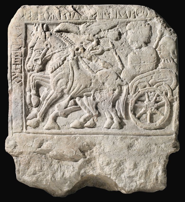
The fact that funerary monuments are differ-
ent in every city reflects their level of autonomy and
independence. In Este, a pyramidal engraved cippus
distinguishes important graves or groups of graves. In
Padova, engraved and decorated stela with the image
of their owners could be placed not only near a grave
or a group of graves, but even near the edge of the
necropolis (Fig. 9.4) (Gamba et al. 2008). Necropoleis
and cities are furthermore often connected through
a coherent orientation of roads and structures (see
Gambacurta 2020). b
Borders and shrines
Figure 9.4 Padova, funerary stone monuments:
Very early in the process of making cities, the definition a) Camin, late sixth century bc, Venetic inscription:
of boundaries and their structures emerges. First, I will Puponei ego Rakoi ekupetaris; b) Albignasego, third
discuss the typology of structures, because we have century bc, Venetic inscription: [(-)--]steropei A[-]
identified at least three very similar examples of border ugerioi ekupetaris ego (from Gamba et al. 2013,
structure, the oldest in Oderzo, one in Padova and the 359–60 and 370).
112Making cities in Veneto between the tenth and the sixth century bc
latest in Este. The first example is a double palisade to the east. Another one appeared during the Hel-
located near the northwestern border of Oderzo, next to lenistic period to the south. Overall, five shrines were
the river, making its banks particularly steady, dating to constructed for the spiritual and devotional needs of
the tenth–ninth century bc (Gambacurta & Groppo 2016, the people, who offered everyday objects and bronze
32–3, fig. 4–5). The second example is a similar double figurines and sheets with their own depictions to dif-
fence situated on the riverbank to the north of Padova, ferent gods, sometimes accompanied by processions.
dated to the early eighth century bc (De Min et al. 2005, A bronze cup with the oldest inscription in the Venetic
85–6, fig. 98). The last example is a massive fence with a language and alphabet was found in the western shrine.
small quay used during the sixth century bc along the The cup is probably an imported Etruscan kylix dating
east side of Este, with a similar construction along the to the second half of the seventh century bc, which
south side of the city (Ruta Serafini & Salerno 2006, figs. was modified (it was missing a foot and two handles
1 and 3). The analysis of these examples leads me to were added) and engraved with a votive inscription
further questions concerning boundaries and borders, indicating that the cup was dedicated to a twin-deity,
such as: what was the nature of borders? Was the border perhaps similar to Dioscuri (Locatelli & Marinetti 2002).
just a place, maybe marked by morphological features, In Roman times, a temple dedicated to the Dioscuri
or something more? Was there an institutional area or was erected nearby (Baggio Bernardoni 1992, 324–31).
a sacred idea? In my opinion, it is difficult to answer Perhaps the most important shrine in Este and
these questions for this period at this stage of research. in all of Veneto is situated on the southeast side of the
In the future, however, I hope to explore how Venetic city boundary. It marked the border between the city
people developed a clear idea of borders and frontiers and the surrounding territory on the route to Adria
with sacred and political implications. For example, and the sea, and likely represented a sacred place for
they had specific gods for their frontiers and borders, as all Venetic people. It was dedicated to the goddess
shown by the inscribed stones from Vicenza, dedicated Reitia.6 Worship at this shrine was continuous until
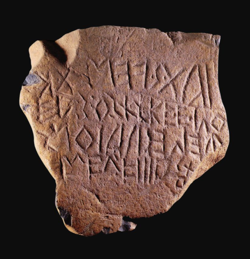
to Termonios deivos (Gamba et al. 2013, 320). the second century ad. During Roman times, Reitia
The connection between boundaries and shrines likely became conflated with Minerva. In this sacred
in Greek cities has been established by the research of place, many inscriptions and implements to teach and
François de Polignac (1991). Considering these data, to learn writing were found, as well as approximately
we can no longer underestimate the meaning and the 14,000 objects originating from other cities and abroad.
topography of sanctuaries in their relationship with It is quite relevant that the styli for writing were all
ancient Etruscan and Italic cities. During the Iron dedicated to the deity by women, and this likely had
Age, there were many sacred places in Veneto, not very interesting social implications (Marinetti 1992,
only connected to settlements, but also with territo- 142–4; Ruta Serafini 2002, 99–100).
rial features, such as boundary shrines like Lagole di For many years, Reitia was considered the main
Calalzo, which from the sixth century bc marked the goddess of the Venetic people; however, now it has
northern border of the region with Celtic lands (Fogo- been established that every city had its own gods or
lari & Gambacurta 2001). Similarly, the shrine in Lova goddesses, often strictly connected with the features
di Campagna Lupia was situated on the border of the of the place itself, which challenges the assumption
Venetian lagoon, although it dates only from the third of the existence of a real ‘pantheon’ (Marinetti 2008).
century bc (Bonomi & Malacrino 2011). Padova and Furthermore, it is likely that commercial value transac-
Este demonstrate the most significant relationship tions took place in the shrines. The shrines were the
between city and shrine. Livy (X.2) wrote about a shrine first and main places for trade and markets, mainly
devoted to Juno in the city centre of Padova; however, of perishable goods. During the seventh century bc,
no clear archaeological traces of this shrine have been however, something changed concerning the nature
identified (Tosi 1994; 2002, 96–9),5 only small votive of luxury goods in funerary contexts. The change was
deposits with a limited number of objects, dedicated most likely due to the transition from a gift economy
between the sixth and fourth century bc (De Min 2005). (cf. Riva in this volume) to the exchange of products
Another shrine has been identified near the hills (Däm- devoted in the shrines and also in the cities, which
mer 1986; 2002), probably at the boundary with Este. was more akin to barter (Greco 1994, 591–3; Smith
The situation in Este is completely different 2004). It is significant, in this respect, that Greek pot-
from Padova. From the seventh century bc, Este was tery imported from the sixth century bc onward is
surrounded by shrines (Ruta Serafini 2002; Maggiani more abundant in the settlements and shrines than
2002). At first, two were constructed to the southeast in funerary contexts (Bonomi 2003; Wiel Marin 2015).
and to the west, followed by two others built during The transition from a gift economy to a barter economy
the following century, to the north, on the hill, and before the development of a real market involved a
113You can also read