Mapping Lawrence County, Indiana - IN.gov
←
→
Page content transcription
If your browser does not render page correctly, please read the page content below
Mapping
Lawrence County, Indiana
  —An Annotated Bibliography—
          1818–1941

       — Earliest Published Map of Lawrence County, Indiana —
                                detail from
   Munsell’s Map of Kentucky ... also Part of Indiana and Illinois, 1818.

      __________________________
                        David Paul Nord
                        Indiana University

    Edward L. Hutton Research Library
           Lawrence County Museum of History
                    Bedford, Indiana
                         2018
© 2018 by David Paul Nord

           ii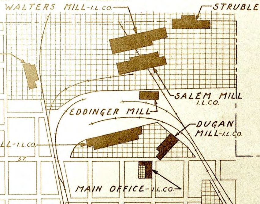
Introduction
    Maps perform many different kinds of work. They are created for armies, government officials, sur-
veyors, road and railroad builders, migrants and shippers, property buyers and sellers, mineral prospectors,
farmers, postal workers, insurance companies, tourists, geography students, and many others. Some map
genres that appear in this bibliography are:

            U.S. atlases                  railroad maps                      geological maps
            county atlases                city directory maps                topographic maps
            state atlases                 fire insurance maps                soil maps
            river navigation maps         postal maps                        industry maps
            road maps                     plat maps                          park road and trail maps

    Libraries have collected maps for centuries, but in recent years public access to historic maps has been
revolutionized. Many libraries, government agencies, and private collectors have made their map collec-
tions freely available online. Just as important, they have begun to scan their maps at high-resolution and to
make those scans user friendly. Digital maps are now easy to use in interactive displays and are often
downloadable in large files. These are transformative technological developments. In paper form, maps are
typically large-format documents. In the past, the details of large historic maps were often lost in the micro-
filming or digitization process. That’s no longer true. Now big maps can be found online and studied in
their original sharp detail. For example, the Lawrence County map on the cover of this booklet is a tiny
section of a very large map. Yet even in this reproduction of a small detail, the original engraving is sharp
and readable. In other words, any reader who has an Internet connection now has access to high-quality
copies of many—though not all—of the extant historic maps of Lawrence County, Indiana.

    This bibliography depends on this new world of digital maps. My aim is to provide, wherever possible,
links to online sources. Mapping Lawrence County, Indiana exists in digital format (PDF) as well as a
printed booklet. The PDF version is available online as an e-book at the Indiana Historical Society, the In-
diana State Library, and other library collections. It has clickable links to individual maps listed, if they are
posted online. If you are using the bibliography in print, you can track down the digitized maps by search-
ing for their titles and dates at the Web sites of the libraries and collections listed below and at the end of
each entry. Many are available in more than one collection. I’ve listed the collection that has the best scan.
Here are the names and the full URLs of all the online map collections cited in the pages that follow:

    Ball State University, Indiana Natural Resources Maps
    http://libx.bsu.edu/cdm/landingpage/collection/InNatRes

    Boston Public Library, Norman B. Leventhal Map Center
    https://www.digitalcommonwealth.org/collections/commonwealth:41688024w

    David Rumsey Map Collection
    http://www.davidrumsey.com/

    Hathi Trust Digital Library
    https://www.hathitrust.org

    Indiana Academy of Science, Proceedings
    https://journals.iupui.edu/index.php/ias/issue/archive

    Indiana Historical Society, Digital Images Collection
    http://images.indianahistory.org/cdm

                                                       1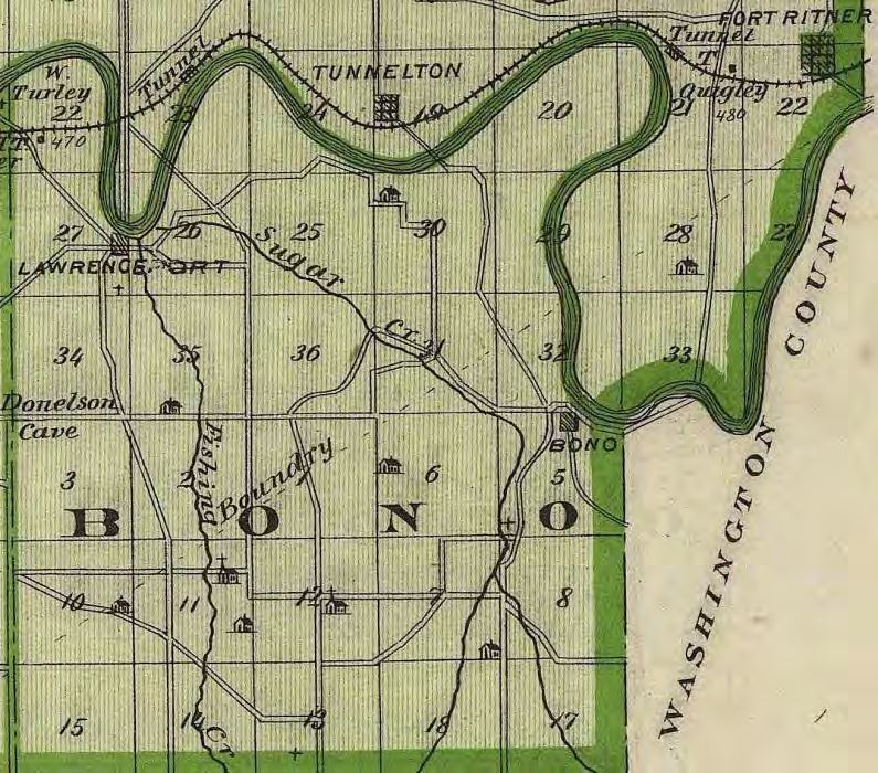
Indiana State Library, Digital Collections
    http://cdm16066.contentdm.oclc.org/cdm/ISLdigitalcollections

    Indiana University-Bloomington, IU Scholar Works, Indiana Geological Survey
    https://scholarworks.iu.edu/dspace/handle/2022/154

    Indiana University-Bloomington Libraries, Digital Library
    https://iucat.iu.edu/catalog/advanced

    Indiana University-Bloomington Libraries, Indiana Historic Maps
    http://webapp1.dlib.indiana.edu/images/splash.htm?scope=images/VAC3073

    Indiana University-Bloomington Libraries, Indiana State Highway Maps
    https://libraries.indiana.edu/indiana-state-highway-maps

    Indiana University-Bloomington Libraries, Topographic Maps
    https://libraries.indiana.edu/topographic-maps

    Indiana University-Bloomington Libraries, Union List of Sanborn Maps
    https://libraries.indiana.edu/union-list-sanborn-maps

    Internet Archive
    https://archive.org/

    IUPUI Library, Historic Indiana Maps
    http://www.ulib.iupui.edu/collections/HIM

    IUPUI Library, Historic Indiana Atlases
    http://www.ulib.iupui.edu/collections/HistAtlas

    IUPUI Library, Historic Indiana Plat Books
    http://www.ulib.iupui.edu/collections/indianaplat

    Library of Congress, Geography and Map Division
    https://www.loc.gov/maps/collections/

    ProQuest, Digital Sanborn Maps
    https://proquest.libguides.com/dsm/browse

    United States Geological Survey, Historical Topographic Map Explorer
    http://historicalmaps.arcgis.com/usgs/

    United States National Archives
    https://catalog.archives.gov/

    University of Illinois at Champaign-Urbana, Historical Maps Online
    https://digital.library.illinois.edu/collections/810d3fa0-e3fb-012f-c5b6-0019b9e633c5-a

An interesting Web site to search for other maps and map collections is:

    Old Maps Online — an aggregator of map collections
    http://www.oldmapsonline.org/

                                                        2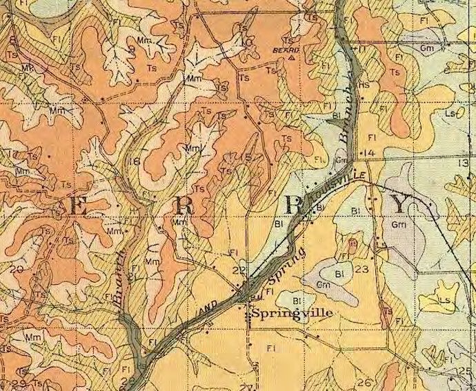
Contents

Part I: Indiana Maps                                                                             4
  With one important exception, the maps in this section are all state-level maps of Indiana. They include
  early state maps, railroad maps, geological maps, and early 20th-century motoring maps. There are so
  many surviving 19th-century and early 20th-century maps of Indiana that this section must be very se-
  lective. It’s merely a sampling of state maps that have useful portrayals of Lawrence County.

Part II: Lawrence County Maps                                                                   14
  This section seeks to be fairly comprehensive. It includes every pre-1941 Lawrence County map that I
  know about. Many, but not all, of these maps are available online. Those that are not available online
  are held in paper form at the Hutton Research Library, the Indiana State Library, the Indiana Historical
  Society, Indiana University–Bloomington, and other libraries. Other historic maps of the county are
  surely out there in private hands and government archives. But these are the ones I’ve found.

Part III: City and Town Maps                                                                    33
  Pre-1941 maps of Bedford, Mitchell, and Oolitic come in several forms, including plat maps, limestone
  industry maps, topographic maps, city directories, insets in county maps and atlases, and fire insurance
  maps. The 1879 Atlas of Lawrence County also has inset maps of sixteen of the county’s small towns
  and villages, including some that no longer exist and some that scarcely existed even in 1879.

Part IV: Spring Mill State Park Maps                                                            47
  Several 19th-century Indiana state maps show Spring Mill as a cross-roads village in Lawrence County.
  Several county maps show the roads, geological features, and other details of the Spring Mill area be-
  fore it became a park. This section of the bibliography, however, includes only maps specifically of
  Spring Mill State Park after it was designated as a state park in 1927.

Part V: Index                                                                                   51

                                       — Note to Readers —
                        Within each section of the bibliography, the maps are listed
                              in chronological order by date of publication.

                                                   3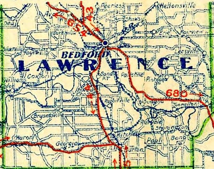
Part I

                                     Indiana Maps
     Indiana became a state (1816) and Lawrence County became a county (1818) at the dawn of a great age
of American cartography. In the early decades of the nineteenth century, Americans in ever-increasing
numbers moved west of the Appalachian Mountains. Meanwhile, in major eastern cities, especially Phila-
delphia and New York, large publishing houses emerged and developed new technologies for printing illus-
trations, including maps. In Indiana and adjacent states, systematic government land surveys were conduct-
ed and their results published. Whether Americans were moving or staying put, they all wanted maps of the
new states and territories. And maps they got—ranging from small, roughly printed fold-out maps in cheap
travelers’ guidebooks to large, beautifully engraved, hand-colored, leather-bound atlases. Hundreds of Indi-
ana maps were published in the nineteenth century; more in the twentieth. After 1818, all included Law-
rence County. This part of the bibliography lists just a handful of those maps to illustrate how Lawrence
County was depicted in Indiana state maps over time.

    Three common types of state maps are sampled here: Indiana State Maps, Railroad Maps, and Indiana
Automobile Motoring Maps. Within each section, the maps are listed in chronological order. Most are held
in multiple collections. I have listed the most accessible and readable online source for each map. In the
PDF version of this bibliography, if the map is available online, the name of the collection is an embedded
hyperlink to that map.

                                         **************

        Indiana State Maps
Shelton & Kensett’s Map of the State of Indiana, by W.
Shelton and T. Kensett. [Connecticut]: Shelton & Ken-
sett, 1817.

    This nicely engraved, hand-colored map, one of the first
    state maps of Indiana, was based on U.S. government
    surveys showing the Second Principal Meridian and the
    Base Line that intersected near Paoli, plus the grid of
    six-mile-square townships that was laid across the state.
    (For more on the original surveys, see the first entry in
    the Lawrence County section, page 14.) The map detail
    reproduced here shows, roughly, the townships in Or-
    ange County that became Lawrence County in 1818, the
    year the county was organized. The White River, Leath-
    erwood Creek, Salt Creek, and Indian Creek appear by
    name. The diagonal dotted lines near the bottom are In-
    dian treaty boundaries.

                                                                            David Rumsey Map Collection

                                                     4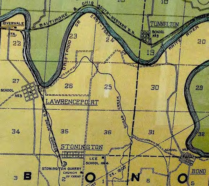
A Map of the State of Kentucky, from Actual Survey, also Part of Indiana and Illinois, by Luke Munsell
and Hugh Anderson. Frankfort: n.p., 1818.

   This is the first large-format map of Kentucky and the most accurate map of that state at that time. It al-
   so is an excellent map of the southern third of Indiana, which in 1818 included nearly all of the sur-
   veyed part of Indiana. Coincidentally, it is the earliest published map to show Lawrence County, which
   was organized as a county in 1818. It is the illustration on the cover of this booklet. Given that Munsell,
   a Frankfort surveyor, was most concerned with Kentucky, his Indiana map is remarkably detailed and
   accurate. In Lawrence County, it shows the White River and the major creeks as well as the village of
   Bono and Speed’s Ferry (a.k.a. Blackwell’s Ferry). This ferry was an important crossing of the White
   River at Palestine, the new county seat. The Roman numerals are the townships, numbered north from
   the main east-west survey Base Line, just south of Paoli. The line marked Meridian is the main north-
   south survey line, the Second Principal Meridian, memorialized today as Meridian Road in Mitchell.

                                                          Library of Congress, Geography and Map Division

Map of Indiana, by John Melish. Philadelphia: John
Melish, 1819.

   This is a revised edition of John Melish’s 1817 map
   of Indiana, which is usually considered the first map
   of the state. The 1819 edition is the first Indiana state
   map to show Lawrence County by name. Melish was
   a rising Philadelphia mapmaker and the publisher of a
   popular travelers’ guide. The map detail here is Law-
   rence County, showing the village of Bono and
   Speed’s Ferry. Like most large maps of the era, this
   one is engraved on copperplate and is hand colored.
   The Indiana Historical Society has a good interactive
   online version of this 1819 edition; the Boston Public
   Library online collection has the 1817 first edition.

                                                       Indiana Historical Society, Digital Images Collection
                                                   Boston Public Library, Norman B. Leventhal Map Center

Ohio and Indiana, by Henry S. Tanner, in A New American Atlas of
the Several States of the North American Union. Philadelphia: H.S.
Tanner, 1823.

   This is the first edition of what some consider the finest atlas pub-
   lished in the United States in the nineteenth century. The Indiana
   map, engraved in 1819, is one of the first to show the county seat of
   Lawrence County: Palestine. (The county seat was moved to Bed-
   ford in 1825.) As in earlier state maps, Speed’s Ferry appears in
   Lawrence County, but still no roads. The two main roads in Indiana
   ran south of Lawrence County and are well depicted on this map:
   the Cincinnati–Vincennes Road via Orleans and the New Albany–
   Vincennes Road via Paoli.

                                                                             David Rumsey Map Collection
                                                      5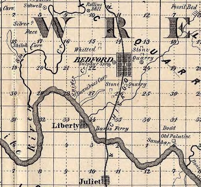
Indiana, by Anthony Finley, in A New General Atlas Comprising a
Complete Set of Maps, Representing the Grand Divisions Of The
Globe. Philadelphia: Anthony Finley, 1831.

   This Indiana map shows Bedford, which became the seat of Law-
   rence County in 1825. It also is the first map to show a road
   through Lawrence County, crossing the river at Palestine via
   Blackwell’s (Speed’s) Ferry. This was a road authorized by the
   state General Assembly in 1821, and it became an important
   stagecoach road between Indianapolis and Fredonia (near Leav-
   enworth) on the Ohio River. Indianapolis was founded in 1821
   and became the seat of state government in 1824.

                                                                     David Rumsey Map Collection

Map of Ohio and Indiana, Exhibiting the Post Offices,
Post Roads, Canals, Rail Roads, &c, by David H. Burr.
London: John Arrowsmith, 1839.

   Prepared by David Burr, the first staff cartographer of
   the U.S. Post Office, this map not only shows post
   roads; it specifies the type of road and the mileage be-
   tween post offices. The main north-south road through
   Spring Mill and Bedford in Lawrence County was a
   Four-Horse Mail Coach Road. This was the road from
   Indianapolis to the Ohio River via Martinsville, Bloom-
   ington, Bedford, and Paoli. The roads shown with dot-
   ted lines were Two-Horse Mail Coach Roads. The oth-
   ers were one-horse or sulkey post roads. This is the ear-
   liest map showing the main roads through Spring Mill.

                                                                     David Rumsey Map Collection

Indiana, by Sidney E. Morse and Samuel Breese, in Morse's
North American Atlas. New York: Harper & Brothers, 1845.

   This is the first Cerographic atlas printed in America. Cerog-
   raphy was a mapmaking process that was easier than engrav-
   ing on copperplate or steel, though not as aesthetically pleas-
   ing. It was especially good for placing text onto maps. This
   state map has no roads but shows more towns than earlier
   maps. In Lawrence County these towns appear: Marysville,
   Springville, Bedford, Liberty, Sinking Spring, Port William,
   Paris, Lawrenceport, Hamer’s Mill (Spring Mill), and Bono.
   This is one of the earliest maps to show Lawrenceport, which
   was platted in 1837.

                                                                     David Rumsey Map Collection

                                                    6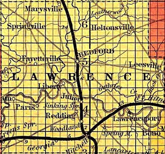
Colton’s Map of the State of Indiana, by J.H. Colton.
New York: G.W. & C.B. Colton & Co., 1869.

   J.H. Colton was a prolific American mapmaker in the
   nineteenth century. This 1869 edition of his popular
   map of Indiana nicely shows the grid of townships and
   square-mile sections. The numbers at the bottom of this
   map detail illustrate how the sections in each township
   were numbered. Though not specifically a railroad map,
   it shows the impact of railroads on town growth. New
   railroad towns in Lawrence County, founded in the
   1850s and 1860s, include Juliet, Redding, Woodville,
   Scottville, Fort Ritner, and Georgia—and the most im-
   portant railroad town in the county, Mitchell.

                                                Boston Public Library, Norman B. Leventhal Map Center

New Topographical Atlas and Gazetteer of Indiana, by
Geo. H. Adams. New York; Indianapolis: Geo. H. Ad-
ams & Co., 1871.

   This early Indiana atlas includes ten hand-colored maps,
   one of Lawrence and nearby counties. It shows towns,
   creeks, civil townships, sections, railroads, and a few
   roads. It is also shows Morgiana as a place near Spring
   Mill village. The post office at Spring Mill closed in
   1859. But, briefly, in the early 1870s, Spring Mill’s
   leading entrepreneur Jonathan Turley was appointed
   postmaster of a new post office called Morgiana. It may
   have been at his house, which was located just east of
   Donaldson Cave on the road from Mitchell to Spring
   Mill to Bono. A widely available reprint edition of this
   atlas was published in 1975.
                                                               IU-Bloomington Libraries, Digital Library

Geological Map of Indiana: Showing Location of Stone Quar-
ries and Natural Gas and Oil Areas, by S.S. Gorby, state geolo-
gist. Indianapolis: Indiana Department of Geology and Natu-
ral History, c.1890.

   Geological maps published by government agencies became
   more common, more accurate, and more beautiful in the late
   nineteenth century. This was the era of a natural gas boom in
   Indiana, so this colorful map focuses on gas fields in the An-
   derson, Marion, and Kokomo areas. But it also pays attention
   to the geological industry that was beginning to boom in Law-
   rence County: stone quarrying and milling. The green shaded
   area on the map indicates “Sub Carboniferous—Limestone.”
   The red circle indicates a limestone quarry area.

                                                   Ball State University, Indiana Natural Resources Maps
                                                   7
Post Route Map of the State of Indiana, Showing
Post Offices, by A. Von Haake. Washington, D.C.:
United States Post Office Department, 1903.

   This map suggests the connection between postal
   service and rail service by the early 20th century.
   The map detail here shows the post offices in
   Lawrence County in 1903. All were either on
   railroad lines or were reached directly from rail-
   road depots. This map marks distances as well as
   routes. All the post offices in the county received
   six-day-a-week service. Many post offices of
   1903, in Lawrence County and throughout the
   state and the country, have disappeared from the
   landscape and even from public memory. An ex-
   ample of that is Paul, southeast of Mitchell. Paul
   was a post office between 1899 and 1903. This
   map codes it as a village. In fact, it was just a
   store and blacksmith shop. Today, it’s gone.

                                                  Boston Public Library, Norman B. Leventhal Map Center

   Railroad Maps
Railroad Map of Indiana, by Thomas A. Morris. New York: Van Norden & Amerman, 1852.

   In the 1850s, railroad mania swept Indiana. The state had barely 100 miles of railroads in 1850; by the
   end of 1854 some 1,400 miles of rail had been laid. Hoosiers were crazy for railroads and for railroad
   maps. This 1852 railroad map shows projected lines as well as completed ones, including the New Al-
   bany & Salem Railroad, which had reached only as far north as Juliet in Lawrence County by 1852,
   and the Ohio & Mississippi Railroad, which did not begin construction anywhere in Indiana until 1854.
   The projected route of the O & M RR through Lawrence County is incorrectly located on this map. But
   the gist of it is accurate: Lawrence County was to be a rail crossroads.

                                                         Library of Congress, Geography and Map Division

Gest’s Map of Railways Centering at Cincinnati with their Tributary Lines in Adjoining States and Can-
ada West, by I.T Lewis. Cincinnati: E. Gest, 1853.

   This railroad map of the Midwest in 1853 is a piece of cartographic propaganda. Its aim is to portray
   Cincinnati, rather than Chicago, as the rail gateway to the West. A key to that claim was the Ohio &
   Mississippi Railroad between Cincinnati and St. Louis, then just beginning construction. The projected
   route of the O & M through Lawrence County is incorrect on this map, but it does show roughly the
   railroad’s route via the White River valley. Most important, it shows what the title proclaims—that this
   line was destined to make southern Indiana tributary to the business interests of Cincinnati.

                                       University of Illinois at Champaign-Urbana, Historical Maps Online

                                                     8
A New and Complete Rail Road Map of the United
States, by William Perris. New York: Korff
Brothers, 1858.
This is a map of the entire eastern half of the
United States. The map detail here shows the
centrality of Indianapolis as the rail capital of In-
diana. It also highlights the Lawrence County in-
tersection of the New Albany & Salem Railroad
(linking the Ohio River and Lake Michigan) and
the Ohio & Mississippi Railroad (linking Cincin-
nati and St. Louis), both completed in the 1850s.
The most difficult section of the O & M lay in
Lawrence County, where two tunnels and several
rock cuts were required. The final spike was
driven at the Mill Creek cut near Spring Mill in
1857. The New Albany & Salem (later called the
Monon) and the O & M (later the B & O) gave
birth to new towns in Lawrence County. This
map is one of the first to show the most im-
portant of those new railroad towns, Mitchell,
which quickly grew up at the intersection of the
New Albany & Salem and the Ohio & Mississip-
pi railroads.
David Rumsey Map Collection
Johnson’s Map of Indiana Showing the Railroads
and Townships, by A.J. Johnson. New York: A.J.
Johnson, 1858.
This popular state railroad map shows, with
dominating black lines, the two railroads that
were completed through Lawrence County in
1854 and 1857. It also shows some of the new
railroad towns in Lawrence County, including
Juliet. For a couple of years, Juliet prospered as
the northern terminus of the New Albany and
Salem Railroad before the White River Bridge
was completed. After the bridge was finished,
Juliet faded away. County roads also appear on
this map, though not very accurately drawn.
Spring Mill was still a crossroads in 1858, but
it would soon be eclipsed by Mitchell as the
main nexus of wagon roads as well as railroads
in southern Lawrence County.
Library of Congress, Geography and Map Division
9State of Indiana, by A.F. Dinsmore and
George U. Mayo. [Washington, D.C.]: Gen-
eral Land Office, 1886.
This well-made map traces and labels sev-
eral of the creeks of Lawrence County and
some of the towns founded after the Civil
War, such as Guthrie, Erie, and Williams.
In addition to the New Albany and Salem
Railroad and the Ohio & Mississippi Rail-
road, the map includes the Bedford &
Bloomfield narrow gauge railroad, which
was built in the 1870s and brought rail ser-
vice to Avoca and Springville. The stations
on the O & M are fairly accurately located:
Fort Ritner, Tunnelton, Rivervale, Mitchell,
Georgia, and Huron.
Boston Public Library, Norman B. Leventhal Map Center
Galbraith’s Railway Mail Service Maps,
Indiana, by Frank H. Galbraith. Chicago:
McEwen Map Company, 1897.
This large-format, illustrated map was
designed to help railway mail clerks lo-
cate post offices. The map shows the
main railroads in Lawrence County in
1897. Besides the New Albany & Salem
Railroad (renamed the Chicago, Indian-
apolis, and Louisville in 1897) and the
Ohio & Mississippi Railroad (the Balti-
more & Ohio Southwestern after 1893),
this map also shows the Bedford &
Bloomfield narrow gauge, the River-
vale-Bedford branch of the B & O (an
orange line), and the Evansville &
Richmond Railroad (a red dotted line), which later became part of the Milwaukee Road. This map
marks “Red Cross,” which was a post office in Lawrence County from 1893 to 1913. Red Cross was a
rural retreat donated to Clara Barton’s American Red Cross organization in 1894 by Dr. Joseph Gard-
ner of Bedford.
Library of Congress, Geography and Map Division
10Indiana Automobile Motoring Maps
Mendenhall’s Guide and Road Map of Indiana,
Showing Main Touring Routes & Good Roads, by
C.S. Mendenhall. Cincinnati: C.S. Mendenhall,
1906.
Throughout the nineteenth century, publishers
issued travelers’ guides with fold-out maps. But
travel guides became even more popular and
important in the age of the automobile. In the
early 1900s Indiana emerged as a center for au-
to manufacturing and auto travel. C.S. Menden-
hall published a series of state maps in the first
decade of the century. This map from the 1906
Indiana guide depicts “good” auto roads with
broken lines and main routes highlighted in red.
The red numbers refer to tours that are de-
scribed in the guidebook.
IUPUI Library, Historic Indiana Maps
Scarborough’s Road Map and Motor Guide of
Indiana, by the Scarborough Company. Indian-
apolis: Scarborough Company, 1912.
This is another popular guidebook, similar to
Mendenhall’s, with trip guides keyed to maps.
In 1912 Lawrence County roads were still
rough, hilly, winding, and unmarked. Motorists
were advised to look for landmarks based on
mileage. For example, on the Bedford–to-
Bloomington trip, the guide has this entry for
Needmore at mile 5.9: “Take right fork, follow
telephone poles, winding road, hilly.”
IUPUI Library, Historic Indiana Atlases
Indiana State Highway Maps, in Yearbook of the State of Indiana, by the Legislative Reference Bu-
reau, et al. Indianapolis: Wm. B. Burford, 1917–1950.
This annual publication included official state highway maps beginning in 1917, continuing through the
1920s and into the 1930s. These are not high quality, but they do show the state’s developing highway
network. IU-Bloomington Libraries has a resource page with links to online versions of these maps,
1917, 1923–1932.
IU-Bloomington Libraries, Indiana State Highway Maps
11Rand McNally Official Auto Trails Map, 1920,
Indiana, by Rand McNally and Co. Chicago:
Rand McNally, 1920.
Rand McNally began publishing maps, rail-
road guides, and atlases in the 1870s. The
company published its first automobile road
map in 1904 and soon became a leader in the
field. The old nineteenth-century stagecoach
road from Indianapolis to Paoli to Fredonia
had evolved into the main north-south road
in Lawrence County. In 1920 it was not yet
numbered as State Highway 37, but it fol-
lowed that general route. This map labels
that road the Dixie Highway (coded #25 on
the map detail). The Dixie Highway was a
project promoted by Indianapolis business-
man Carl Fisher. It ran via several alternate routes from Chicago and northern Michigan to Miami. A
section of old Highway 37 in Lawrence County near the piers of the old White River bridge is still
called the Dixie Highway. The roads coded #90 and #97 are parts of what this map calls the French
Lick Route and the Midland Trail.
Indiana State Library, Digital Collections
Map of Indiana Showing Points of Interest and
State Highways, by Indiana State Highway
Commission. Indianapolis: Indiana Department
of Conservation, Richard Lieber, director, 1923.
The state began promoting tourism with maps
in the 1920s. This highway map includes points
of interest, ranging from the Indiana Dunes in
the north to Wyandotte Cave in the south. Two
points of interest are marked in Lawrence
County: (39) Devil’s Backbone, the narrow
ridge between the White River and Guthrie
Creek; and (32) the site of Spring Mill before it
became a state park. Here is the (inaccurate)
Spring Mill description: “Donaldson Cave, 2
1/8 miles southeast of Mitchell. Accessible by
special arrangement only. The ruins of a three-
story stone mill lie about one-fourth mile down
the creek from the cave.”
IUPUI Library, Historic Indiana Maps
12State Highway System of Indiana, by Indiana
State Highway Commission. Indianapolis: In-
diana State Highway Commission, 1929.
This is an example of an official State High-
way Commission map from the late 1920s. It
labels numbered state and federal routes, and
indicates which roads were paved with earth,
gravel or stone, or “pavement,” which includ-
ed macadam as well as concrete, brick, or as-
phalt. By 1929 in Lawrence County, U.S.
Highway 50 and State Highway 37 appear on
the map. Highway 50 was largely treated
stone; Highway 37 was paved between Paoli
and Oolitic, but “under construction” between
Oolitic and Bloomington. Until the 1930s,
Highway 50 was routed along Highway 37
from Bedford to Mitchell.
Indiana State Library, Digital Collections
Official State Highway System of Indiana,
1939, by Indiana State Highway Commis-
sion. Indianapolis: Indiana State Highway
Commission, 1939.
In the 1930s, Indiana highways and the
maps that traced them took on their mod-
ern forms. In Lawrence County, the fed-
eral and state roads were routed and
numbered pretty much as they are today.
The major differences between then and
now are the rerouting of Highway 58 in
1941 to make way for the Naval Ammu-
nition Depot at Burns City (later renamed
Crane), and the building of Highway 446
in connection with the development of
Lake Monroe in Monroe County in the
1960s. This 1939 map still shows the
same “points of interest” in Lawrence
County as in 1923: the Devil’s Backbone
and Spring Mill, a state park since 1927.
Indiana State Library, Digital Collections
13Part II
Lawrence County Maps
Unlike Part I on state maps, Part II on Lawrence County maps seeks to be fairly comprehensive. It in-
cludes all of the maps of the county, published through 1941, that are preserved and catalogued in libraries
and online collections or are publicly accessible in government offices. Some of these maps have been dig-
itized, some have been reprinted in modern editions, but many survive only in their original paper form. If
they were available online in 2018 when this bibliography was compiled, clickable links are provided.
The maps in Part II include general county maps; plat and property maps; geological and topographic
maps; land use and soil maps; stone industry maps; road and railroad maps; and postal maps. Most were
engraved or lithographed and professionally published; a couple were hand-drawn by amateurs. All were
made by cartographers, whether professional or amateur, who cared about Lawrence County and who left
to us a record of the county, preserved graphically and sometimes beautifully in space and time.
**************
Plats & Field Notes, Lawrence County. Cincinnati:
United States Surveyor General, 1806–1811.
The first professional maps of the land that became
Lawrence County were drawn shortly after 1805 by
U.S. government surveyors. Surveys of Indiana
were based on a north-south Principal Meridian and
an east-west Base Line drawn in 1805. Those lines
intersected at a point six miles south of Paoli. The
land was then divided into a uniform grid of
townships six-miles square, which were labeled
according to their distance north or south of the
Base Line and east or west of the Meridian. Each
township was then divided into square-mile
“sections” numbered 1–36. The surveyors recorded
their work in field notes and hand-drawn maps for
each township. Those township maps created the
property survey system that appears on many of the
maps in this bibliography and that still applies today. The detail reproduced here is from a map drawn
in 1811 by surveyor Arthur Henrie for township TN5 R1W. That code signifies the township that is
five townships north of the Base Line and one township west (called the range) of the Principal
Meridian. This is near where Bedford was later located. The map detail shows four sections along the
White River (sections # 29, 28, 32, and 33), with Salt Creek flowing into the river from the left. (Cf.,
1874 map on page 15.) Those four sections were later subdivided and sold, and those changes were
written in on this map. Voluminous records of the General Land Office are maintained at the National
Archives and the Indiana State Archives in original volumes and in various reproductions, microfilms,
and sometimes digital files. The map shown here comes from a handy online database created by the
Monroe County Surveyor’s Office for the townships in Indiana that later became Monroe and
Lawrence counties when those two counties were organized in 1818. The digital files in this collection
were made from microfilms at the Indiana State Archives. This database is available online at the
Internet Archive.
Internet Archive
14W.H. Stairs’ Map of Lawrence County, Indiana, Com-
piled from Surveys, by W.H. Stairs and W.W. Dill. In-
dianapolis: W. & J. Braden, [186?].
This is the earliest Lawrence County map catalogued
by any library. Earlier printed maps may still exist. As
roads were built, local governments organized, and
railroad routes surveyed, more maps surely were
made and even published. But so far the earliest sur-
viving county map that I have found is this one from
the 1860s. And it is good one. It is a large-format
property map, showing the landowners throughout the
county. It also includes in the margins lists of busi-
nesses, probably patrons of the project. It is accurate
on the routes of rivers, streams, and railroads; it is
fairly accurate on roads. The map detail here shows
the property owners in the Rivervale/Lawrenceport
area, along the Ohio & Mississippi Railroad. Several
are Hamers, the ownership family at Spring Mill, just south of here. George Hamer’s property on the
White River is the site of Boatyard Bend, where in earlier times the Hamers built flatboats to ship
products south by the White, the Ohio, and the Mississippi rivers. The Hutton Library has an original
printing of this map, framed and hanging in the hallway. It is quite deteriorated. The State Library has a
photostat copy of a different edition, in thirteen sheets, each 18 by 14 inches. The exact date of publica-
tion is uncertain. The State Library says between 1860 and 1869. The Hutton Library’s photocopy of
the State Library’s copy has penciled in: between 1866 and 1872. This map is not available online.
Hutton Research Library
Indiana State Library
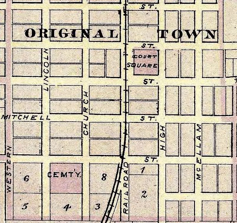
Map of Lawrence County, Indiana, by
John Collett and E.T. Cox. Indianapolis:
Sentinel Company, 1874. Prepared for
Fifth Annual Report (1873), Indiana Geo-
logical Survey, 1874.
This map has been digitized by several
libraries. It marks caves, quarries, and
fossil beds, as well as towns, creeks,
railroads, and section numbers. No
roads appear. The map detail here
shows the Bedford area, including
Rawlins Mill (misspelled Rollins) on
Salt Creek north of Bedford, the most
successful flour/grist mill in the county
at that time. It also shows three settle-
ments on the path to oblivion by 1873:
Liberty, Juliet, and old Palestine. Davis
Ferry was an important White River
crossing until a new “iron bridge” was
built near the site of Liberty in the
1870s. That became the crossing for state
Highway 37 in the 20th century.
Indiana Historical Society, Digital Images Collection
15Map of Lawrence County, in Illustrat-
ed Historical Atlas of the State of In-
diana, by Alfred T. Andreas. Chica-
go: Baskin, Forster & Co., 1876.
This atlas is one of many state at-
lases published in the 1870s. The
original edition includes historical,
statistical, and illustrative material
along with county maps and some
city maps, including Bedford and
Mitchell. (Those maps appear in
the “Town and City Maps” section
of this bibliography.) A reprint edi-
tion published by the Indiana His-
torical Society in 1968 features on-
ly the county maps, a map of Indi-
anapolis, and a few illustrations.
The 1968 edition is still widely
available; the Hutton Research Li-
brary has a copy. The Lawrence
County map in the atlas is simple yet fairly accurate. But in one humorous error, the map mislabels
George Donaldson’s “Shawnee Cottage” near Spring Mill as a “College.” The map detail reproduced
here shows Bono Township and part of Guthrie Township in the southeast corner of the county. The
Ohio & Mississippi Railroad snakes through the White River Valley. Bono was one of the earliest set-
tlements in the county, but the railroad towns of Fort Ritner and Tunnelton, both located at long-
standing White River ferry crossings, eclipsed Bono after the railroad came through in 1857. A bridge
over the river was built at Tunnelton in the 1870s. Both of the two Lawrence County railroad tunnels
appear on this map: Big Tunnel, west of Fort Ritner, and Little Tunnel, west of Tunnelton. Big Tunnel
is still in service; Little Tunnel was “daylighted” in 1899. That’s railroad jargon for blasting the top off
a tunnel to make a deep cut. An excellent image of the Lawrence County map is available at the David
Rumsey Map Collection online. Parts of the original edition can be viewed online at the Indiana Histor-
ical Society. The entire volume can be downloaded from the Internet Archive.
David Rumsey Map Collection
Indiana Historical Society, Digital Images Collection
Internet Archive
Map of the White River from Its Mouth to Bedford, Ind., on the East Fork and to Gosport, Ind., on the
West Fork, drawn under the direction of Major Jared A. Smith. [Washington, D.C.: War Depart-
ment, Corps of Engineers, 1878].
This is a set of thirteen large-format nautical charts of the White River, including a stretch of the river
in Lawrence County. These maps are not available online, and I have found only two libraries that have
copies: the Library of Congress and the Wisconsin Historical Society.
Library of Congress
Wisconsin Historical Society
16An Atlas of Lawrence County, Indiana, by
B.N. Griffing. Philadelphia: D.J. Lake & Co.,
1879.
This atlas is the best set of maps of Law-
rence County published in the 19th century.
(See page 54.) In addition to a general map
of the county, the atlas includes property
maps of townships and inset maps of cities,
towns, and villages. The atlas also includes
pictures of county officials and the county
courthouse, population statistics, and lists
of the patrons of the atlas in each of the
townships. The detail from the Marion
Township map reproduced here shows the
Spring Mill area, including Hamer’s mill,
the Hamer Cemetery, George Donaldson’s
house (Shawnee Cottage), and the caves
that still today attract visitors to the area.
Several of the county roads on this map are
park roads today. The Ohio & Mississippi Railroad bends through the area just north of the village.
This atlas was published in a facsimile edition in 1979 by Unigraphic, Inc., of Evansville. The Hutton
Library, the Bedford Public Library, and many other libraries have copies of that edition. An excellent
online version of the original 1879 edition is available at the State Library.
Indiana State Library, Digital Collections
Geological Map of the Bedford Oolitic Lime-
stone Region (Bedford Sheet), Indiana, by
T.C. Hopkins and C.E. Siebenthal, originally
in 21st Annual Report (1896). Indianapolis:
Indiana Department of Geology and Natural
Resources, 1897.
This is one of two detailed maps of the In-
diana limestone region, stretching from
Owen County to Orange County. The “Bed-
ford Sheet” covers all of Lawrence County
and includes towns, creeks, roads, quarries,
and stone mills. The map is especially good
on the network of railroads in the Bedford
area in 1896, all of which have now been
abandoned. The map detail reproduced here shows some of the developing quarry areas such as Dark
Hollow and Reed Station. This map may be the first to show Oolitic, which became the name of the
quarry town Limestone when a post office was established there in 1896. (There are several Oolitic en-
tries in the “Town and City Maps” section of this bibliography.) Indiana University provides online ac-
cess to the maps and, separately, to the State Geologist’s report.
IU-Bloomington Libraries, Indiana Historic Maps
IU-Bloomington, IU Scholar Works, Indiana Geological Survey
17Map of Lawrence County, Indiana / Compiled and Drawn
from Surveys and Official Records, by G.C. Houston. n.p.
[Indiana?], 1899.
This large property map of Lawrence County was de-
signed mainly to delineate properties and list owners,
but it is an excellent map in other ways as well. It shows
rivers and creeks, roads and railroads. The roads are
coded either “gravel” or “dirt.” This may be the first
county map that labels main roads by their common
names at the time. For example, the gravel road from
Bedford to Bloomington is labeled both the “Bono –
Lafayette State Road” and the “Bedford – Bloomington
Turnpike.” The detail here shows a stretch of that road
(later Highway 37) north of Needmore. The map is held
by the Indiana State Library; it is not posted online.
(Cf., revised version on page 24.)
Indiana State Library
Lawrence Co. [Indiana]. n.p., [c.1900].
This curious little map (14 x 13 inches) is a blueprint
map of Lawrence County. It has no identification or
date printed on it, but the State Library has pegged it to
c.1900. It is pretty crude and sometimes inaccurate. It
shows quarries, roads, and railroads. This must have
been a working copy of the map. Added by hand are
several places not on the printed map, including Cox-
ton, Rabbitville, Buddha, Rivervale, Stonington, Paul,
and Shawswick. The small detail reproduced here
shows the village of Erie with Shawswick penciled in.
Shawswick, a station along the railroad between Bed-
ford and Heltonville, had a post office from 1891 to
1896 . This map is not posted online.
Indiana State Library
Map of Lawrence County, Indiana, Ordered by the Board of Edu-
cation of Lawrence Co. for the Use of the Schools of the County,
by W.W. Thompson. Indianapolis: Wm. B. Burford, [c.1900].
This large-format, multicolored, pull-down schoolroom map
shows townships, sections, roads and railroads, rivers and
creeks, cities and towns, post offices, schools, and some quar-
ries. It is undated but seems to have been published around
1900. The Hutton Library has a well-preserved copy. The map
detail here shows Flinn Township, with five schoolhouses. In
response to a political dispute in the township, the county com-
missioners dissolved Flinn in 1911, and it was absorbed by sur-
rounding townships. This map is not posted online.
Hutton Research Library
18Enumeration District Maps for Lawrence County, Indiana, in Enumeration District and Related Maps,
1880–1990, Records of the Bureau of the Census. Washington: National Archives, 1900–1940.
These maps were used by the Census Bureau in conducting the Decennial Census. For Lawrence Coun-
ty, there are maps for 1900, 1920, 1930, and 1940. Only the 1940 map for Lawrence County is posted
online. It is a crude digital copy of the General Highway and Transportation Map, Lawrence County,
Indiana, 1937, which is held by IU-Bloomington and appears in this bibliography on page 30.
U.S. National Archives
Soil Map, Lawrence County, Indiana, by C.W. Shannon
and L.C. Snider, originally in 32nd Annual Report
(1907). Indianapolis: Indiana Department of Geology
and Natural Resources, 1908.
In 1908 the Indiana Department of Geology and Natu-
ral Resources published soil surveys and maps of sev-
enteen southern Indiana counties, including Law-
rence. The map identifies the various types of soils in
the county. In addition to the usual listings of towns,
creeks, roads, and railroads, this map also indicates
which roads were “improved” and which were still
“earth” in 1907. The map detail shown here covers
four sections (square miles) in the Back Creek-
Leesville area at the eastern edge of the county, where
Knobstone soils (S) meet Harrodsburg soils (\\\\). The
32nd Annual Report and the map, separately, are
available online through IU.
IU-Bloomington Libraries, Indiana Historic Maps
IU-Bloomington, IU Scholar Works, Indiana Geological Survey
Geological Map of the Bedford Oolitic Lime-
stone Region (Bedford Sheet), by C.E. Sieben-
thal, originally in 32nd Annual Report (1907).
Indianapolis: Indiana Department of Geology
and Natural Resources, 1908.
This map is like the one in the 1896 report. It
delineates the region of Bedford oolitic lime-
stone, showing areas of working quarries and
abandoned quarries. The busiest quarry areas
in Lawrence County in 1908 lay in the heart
of the limestone belt in areas north and west
of Bedford, but there were a few outlying are-
as as well with accessible limestone. The map
detail here shows the Heltonville area. This
part of what was known as the Heltonville Limestone Strip is shown in gray. The numbers are section
numbers. The Heltonville Oolitic Limestone Company operated a quarry there between 1890 and 1897.
The 32nd Annual Report and the map, separately, are available online through IU.
IU-Bloomington Libraries, Indiana Historic Maps
IU-Bloomington, IU Scholar Works, Indiana Geological Survey
19Lawrence Co., Indiana. Chicago: Rand McNally, c.1908.
This color map is about 14 inches square. It shows rivers and creeks, roads, railroads, schools, church-
es, and cemeteries. Only one copy has been preserved and catalogued by a library: Regenstein Library,
University of Chicago. It is not available online.
University of Chicago, Regenstein Library, Map Collection
Map of Lawrence County, Indiana, Showing
Rural Delivery Service, by C.W.K. [Wash-
ington, D.C.]: U.S. Post Office Department,
1909.
This official postal map shows towns,
creeks, roads, and railroads, as well as post
offices and rural postal routes. It also
shows schools, churches, and houses.
There are a couple of misidentifications of
towns. For example, Lawrenceport is mis-
labeled Rivervale, a curious error for a
postal map. But for the most part this is a
detailed and accurate county road map.
The detail reproduced here shows the Sil-
verville, Fayetteville, Williams area. The
dark lines (numbered 8 and 16) are postal
routes originating in Williams. The icons
for Silverville and Fayetteville indicate
discontinued post offices. Silverville’s
closed in 1906; Fayetteville’s in 1907.
Indiana State Library, Digital Collections
Railroad Valuation Maps, ICC Bureau of Valuation, Engineering Section. [Washington, D.C.]: U.S.
Interstate Commerce Commission, c.1915–c.1920.
Between 1915 and 1920, the Interstate Commerce Commission collected vast troves of data on Ameri-
can railroads to be used to assess the value of corporate property for setting freight and passenger rates.
Included in this ocean of information were nearly 125,000 maps of railroad properties: mainline rights-
of-way, spurs, sidings, yards, stations, buildings, bridges, and adjoining roads and structures. The maps
were annotated with construction and engineering details. These maps are large blueprints (most are 24
x 56 inches); each covers half a mile to four miles of track. The maps are filed in the records of the ICC
(Record Group 134) at the U.S. National Archives. Though some have been scanned, most remain
available in paper form only. The National Archives holds maps for these railroads operating in Law-
rence County in the 1910s: the Baltimore & Ohio; the Chicago, Indianapolis, & Louisville (Monon);
the Bedford & Wallner; and the Chicago, Terre Haute & Southeastern (Milwaukee Road). The Law-
rence County maps are available to the public at the National Archives but are not posted online.
U.S. National Archives
20Map of Lawrence County. Indianapolis:
J.D. Adams & Co., 1915.
This is an excellent—and rare—county
map. The only library that seems to have
a copy is the Hutton Research Library.
Hutton has two copies, slightly different
printings. A large, color copy is framed
and hangs in the hallway. The provenance
of the map is unknown. J.D. Adams &
Co. of Indianapolis appears on the map as
publisher, but J.D. Adams was a manu-
facturer of road-building equipment, not a
publisher of maps. In addition to towns,
roads, and railroads, the map shows
schools and churches. The detail here
shows the Bono, Lawrenceport, Tunnel-
ton, Stonington area. Between 1901 and
1914, a stone mill operated at Stonington,
linked to Bedford via the Bedford Stone Railroad and the Bedford branch of the B & O, both of which
intersected the mainline B & O Southwestern at Rivervale. The Stonington mill was closed and the
Bedford Stone Railroad abandoned in 1917. This map is not posted online.
Hutton Research Library
Lawrence County, Indiana, by William
Duncan. n.p.: c.1917.
This spare but well-made map was hand-
drawn on graph paper with the squares
representing mile-square sections. Its
purpose was simply to show, with red-
inked lines, the best roads through the
county. The best north-south route was
the Dixie Highway through Oolitic, Bed-
ford, and Mitchell, soon to be State
Highway 37. The best east-west route
was through Leesville to Bedford, down
to Mitchell, and then west through Geor-
gia and Huron. This was the early route
of U.S. Highway 50, until a more direct
connection between Bedford and Huron
was constructed in the 1930s. The detail reproduced here shows the Mitchell intersection of these
roads. Someone, probably not the mapmaker, scrawled in pencil at the bottom of the map that these
roads are in “excellent condition.” This map is not available online.
Indiana State Library
21Topographic Sketch of a Small Area in Western
Lawrence Co., Ind., by Clyde A. Malott, in
Clyde A. Malott, “A Subterranean Cut-Off
and Other Subterranean Phenomena Along
Indian Creek, Lawrence County, Indiana.”
Proceedings of the Indiana Academy of Sci-
ence, 31 (1921): 203–210 (map on page 204).
This small map was created by one of the
best early twentieth-century geologists of
southern Indiana. It shows an interesting ex-
ample of karst hydrology in Lawrence Coun-
ty: the “sink” and “rise” that carried part of
the flow of Indian Creek under the 200-foot
bluff of Boogers Point (sometimes called
Boggers, sometimes Buggers) in Indian
Creek Township. The map also shows how
the old 19th-century Rockport Road, which
is labeled on the map, snaked its way through
the area on its way from Bloomington to the Ohio River at Rockport. The map detail here zooms in on
the area of the sink and rise. This journal is accessible online through IU Libraries as well as other
online collections such as Google Books. The Indiana Academy of Science also has posted its full ar-
chive of the Proceedings online in very good scans.
Indiana Academy of Science, Proceedings
Soil Map, Indiana, Lawrence County
Sheet, by W.E. Tharp. Washington,
D.C.: Bureau of Soils, U.S. Department
of Agriculture, 1922.
The U.S. Department of Agriculture
began conducting systematic soil sur-
veys of Indiana counties in 1902. The
Lawrence County survey was com-
pleted in 1922, and this large, full-
color, highly detailed, beautiful map
was the chief product. In addition to
systematically demarcating the varied
soils in the county, the map shows
roads and railroads, towns and villag-
es, quarries and mills, churches and
schools. The map detail reproduced
here shows the wide variety of soils in
the Springville area in Perry Town-
ship. Springville was one of the oldest settlements in that corner of the country. A post office opened
there in 1827. In the 1870s Springville became a station on the Bedford & Bloomfield Railroad. In the
1880s that railroad was acquired by the Louisville, New Albany & Chicago Railroad, which by the
1920s had been renamed the Chicago, Indianapolis & Louisville (a.k.a. Monon).
IU-Bloomington Libraries, Indiana Historic Maps
22Plat Book of Lawrence County, Indiana, by
W.W. Hixon. Rockford, Ill.: W.W. Hixson &
Co., 192?.
W.W. Hixson & Co. published plat books
(property maps) for all Indiana counties be-
tween approximately 1925 and 1941. The
books are atlases of township maps, showing
property lines and owners. The Lawrence
County plat book—an original of which is in
the IU-Bloomington rare maps collection—
appeared sometime in the 1920s. Copies are
held by other libraries, including the Hutton
Library, the Bedford Public Library, and the
Monroe County Public Library. All extant
plat books in this series have been scanned
and posted online by the IUPUI Library. In
that collection, Lawrence County is in Vol-
ume 3, pages 280–296. The detail reproduced
here shows four sections (four square miles)
in the Avoca area in Marshall Township. Avoca was an early mill-site settlement in the county and lat-
er a station on the Bedford & Bloomfield Railroad, here shown as the Chicago, Indianapolis & Louis-
ville Railway. From the 1920s until 2016, the state operated a fish hatchery at Avoca, fed by water
from a hillside spring.
IUPUI Library, Historic Indiana Plat Books
Topographic Map of Part of Lawrence County, in
Handbook of Indiana Geology, Indiana Department of
Conservation, Publication No. 21, by W.N. Logan et
al. Indianapolis: Wm. B. Burford, 1922.
This fold-out topographic map is tipped into a De-
partment of Conservation report between pages 742
and 743. It shows the western half of the county.
Other small Lawrence County maps appear on pages
224, 740, and 931. This handbook is a major state re-
port that covers many aspects of geology, topogra-
phy, and hydrology, with detailed attention to “Eco-
nomic Geology,” that is, to minerals and ores, oil and
gas, oil shale, stone and road material, coal, lime and
limestone, clays and sands, and so on. The map detail
here is the Huron area in the southwest corner of the
county. Huron was founded as a railroad town during
the building of the Ohio & Mississippi Railroad in
1857. West of Huron the railroad (the Baltimore & Ohio by 1922) descends from the Mitchell Plain,
down the Beaver Creek valley, to reunite with the White River at Shoals. The link included here is to
the fold-out topographic map within a scan of the full report.
IU-Bloomington Libraries, Digital Library
23Lawrence County Archaeologic Map and Plates, by E.Y.
Guernsey. Indianapolis: n.p., 1924. Illustrative material
prepared for “Archaeological Survey of Lawrence
County,” by E.Y. Guernsey, Indiana History Bulletin,
Indiana Historical Commission, extra number, July
1924.
This map marks sites of prehistoric native American
habitation and activity in Lawrence County. The map
shows village sites, quarries, cemeteries, workshops,
caches or pits, burial mounds, Indian springs, pottery,
shell heaps, rock shelters, petroglyphs, and caves.
Guernsey, a Bedford resident, was a Lawrence County
historian, archeologist, and state legislator. He was al-
so a founder of Spring Mill State Park. The map detail
here shows the Williams–Bryantsville area in Spice
Valley Township. The codes mark the sites of villages,
workshops, pottery, burial mounds, etc. The Indiana State Library holds the original map and the draw-
ings of Indian artifacts that appear in the article. The Indiana History Bulletin, published by the Indiana
Historical Commission, is available in many Indiana public and university libraries, including IU-
Bloomington. It also is accessible online at Hathi Trust Digital Library. This “extra number” of the In-
diana History Bulletin is bound into volume 1, 1923–1924.
Indiana State Library
Hathi Trust Digital Library
Map of Lawrence County, Indiana / Compiled
and Drawn from Surveys and Official Records,
by G.C. Houston; revised by J.W. Malott. n.p.
[Indiana?], 1928.
This map is described in its title as a revision,
but it is essentially a corrected reproduction
of the original 1899 Houston map, which ap-
pears in this bibliography on page 18. It was
redrawn and relettered, and a few substantive
changes were made—but very few. In this de-
tail from the Bono area in the southeastern
corner of the county, all the properties and
property owners are identical with 1899.
That’s typical throughout the map. Bono, the
first important settlement in the county, had
dreams of growth, with river access, a state
road authorized, and fantasies of a railroad.
But those dreams never materialized. Most of
the town lots shown here were never devel-
oped and long ago reverted to farm land. The
Indiana Historical Society holds a blueprint copy of this map. The Hutton Library has a large photo-
copy and an excellent original copy that has been digitized. It is not available online.
Indiana Historical Society Library
Hutton Research Library
24Map of the Lawrence County Region of the Indi-
ana Oolitic (Salem) Limestone, Showing Its Areal
Outcrop and Quarries, by W. N. Logan and
Ralph Esarey. Indianapolis: Indiana Depart-
ment of Conservation, Division of Geology, 1928.
In 1928 the state Division of Geology produced
two beautiful large-scale maps of the Indiana
Limestone region. One map covers Owen and
Monroe counties; the other covers Lawrence
County. The maps are especially good at show-
ing how the Salem limestone layer is revealed
in outcroppings along the bluffs and ridges of
rivers and streams. The map detail here shows
the area around the town of Oolitic, which sits
on the ridge between the valleys of Salt Creek
and Goose Creek. The outcrops of the Salem
stone layer appear in red. The squared off red
areas are the quarry districts of Dark Hollow,
Reed Station, and Oolitic. The map also shows
the network of railroads that had been built in this area by the 1920s. This map and the Owen-Monroe
map are held by IU-Bloomington and the State Library. They have not been posted online.
IU-Bloomington Libraries, Map Collection
Indiana State Library
Property Survey of the Quarry and Mill Prop-
erties of the Indiana Limestone Company,
Bedford, Indiana, in Lawrence and Monroe
Counties, 1928–1929, created by J.L. Mann,
chief engineer, et al. n.p.: [Indiana Limestone
Company, 1929].
The 1920s were boom times for the lime-
stone industry in Lawrence and Monroe
counties. This volume is an atlas of plat
maps of dozens of quarry and stone mill
properties owned by the Indiana Limestone
Company (ILCO), which had been formed
in 1926 in a grand merger of 24 of the 42
companies then in business in the stone dis-
trict. The maps show buildings, roads, rail-
roads, quarry openings, and other features. The detail reproduced here is the property that before the
merger had been the John A. Rowe Cut Stone Company in Bedford. It lay between the rail lines of the
Milwaukee Road on the south and the Bedford & Bloomfield branch of the Monon on the north along
Garvey Lane, now John Williams Boulevard. The Rowe mill building is still in use, though not as a
stone mill. The original survey volume is in the archives of the Indiana Limestone Company. The Law-
rence County Surveyor’s Office has a photocopy, which has been digitally scanned and is available to
the public. The Monroe County History Center in Bloomington has a scanned copy, too. Neither of
these scanned copies is posted online.
Lawrence County Surveyor’s Office
Monroe County History Center
25You can also read