Mapping Segregation Google Maps and the Human Rights of Palestinians - 7amleh - Association for Progressive Communications
←
→
Page content transcription
If your browser does not render page correctly, please read the page content below
Mapping                7amleh

Segregation
                       Arab Center
                       for Social Media
                       Advancement

Google Maps
and the Human Rights
of Palestinians

                       September 2018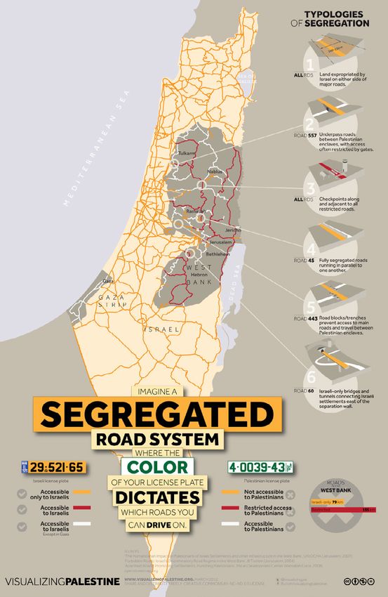
7amleh – Arab Center for Social Media Advancement

Translated to arabic: Dar Layla
Graphic designer: Amjad Badran

This publication was done with the generous support of:

Creative Commons Attribution - NonCommercial - Share-Alike 4.0 (CC BY NC SA 4.0)
https://creativecommons.org/licenses/by-nc-sa/4.0

Contact us:
info@7amleh.org | www.7amleh.org
Tel: +972 (0)774020670
Follow us on Social Media: 7amleh
Index
Introduction											 4

Geopolitical Background									 5

Palestinian Villages Misrepresented or Missing on Google Maps                                  6
       The Naqab – Palestinian Bedouins as Israeli Citizens under Civil Law		                  7
                     Example: Basma Abu-Qwaider, Al-Zarnoooq village                           9
       Area C – Palestinians under Israeli Military Law                                        9
                     Example: Raed Abu Joudeh, Jiftlik, Jordan Valley                         10
       International Law and Human Rights Law Perspective                                     10
Route Planning                                                                                12
       Google Maps                                                                            14
       Maps.me                                                                                14
       Waze                                                                                   15
       Comparison                                                                             16
Terminology and Availability                                                                  19
Technological Feasibility and Google Maps Alternatives                                        21
Conclusions & Recommendations                                                                 22
       Google’s Vision and Responsibility                                                     22
       Recommendations                                                                        23

                                  Mapping Segregation - Google Maps and the Human Rights of Palestinians   / 3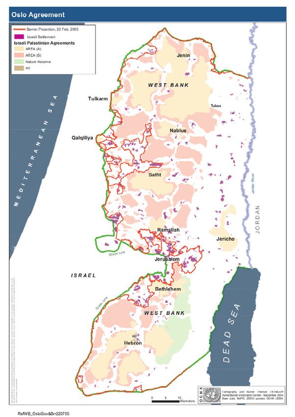
INTRODUCTION
             In August 2016, Google came under global scrutiny for its representation of Palestine
             following the removal of the terms “West Bank” and “Gaza” from its maps. Google responded
             by stating that the names were removed due a technical bug and additionally asserted
             that it had never previously named “Palestine” on its maps. Furthermore, some critics
             have pointed to Google Maps as perpetuating the Israeli government’s refusal to recognize
             Bedouin ownership over certain areas of the land by leaving out names of Palestinian
             villages as well as prioritizing illegal Israeli settlement routes on its map.

             In a context where land and ownership are highly contentious and inherently political,
             Google holds immense power as the largest source of digital geographic data in the world,
             to shape and legitimize certain interpretations of the physical world and the politics that
             underpin it. As this report will show, because human rights extend into the digital sphere,
             the ways in which this physical world is represented in online maps can even run counter
             to the exercise of the most basic and essential human rights. This report analyses the
             mapping practices of Google Maps in relation to the occupied Palestinian territories and
             how that helps form public opinion that serves the interests of the Israeli government,
             while simultaneously contradicting Google's responsibilities under international human
             rights frameworks.

             This will be done by firstly summarizing the geographical and political situation of Israel
             and the occupied Palestinian territories and analyzing Palestinian villages and their
             representation on Google Maps, including Google’s route planning within these locations.
             Finally, the terminology that Google maps uses and its route planning in specific locations
             will be examined, before presenting conclusions and recommendations. The methodology
             used for this report is based on international human rights standards.

             Despite countless attempts, a Google Maps representative could not be reached to comment
             on this issue. Although a few Google representatives initially agreed to answer questions
             about the issue, in the end, none of the persons at Google were actually available to
             comment.

4 /   7amleh - Arab Center for Social Media Advancement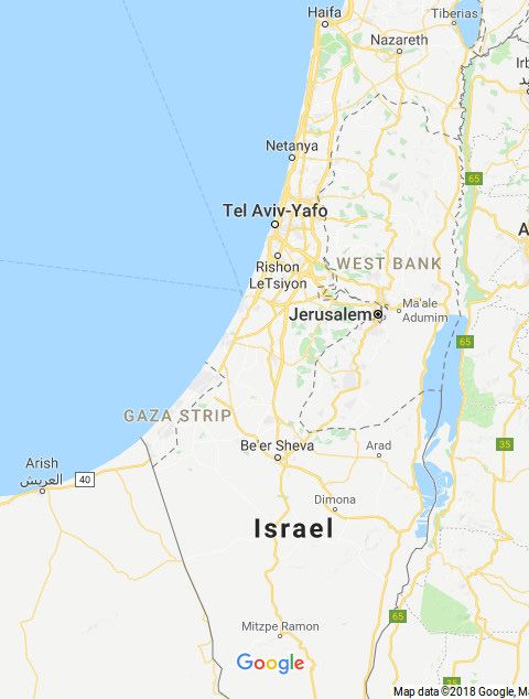
Geopolitical Background
In this section, an outline of the following will be given: the terminology used when
discussing the occupied Palestinian territories, the territorial division and fragmentation of
historical Palestine and its repercussions on Palestinian human rights, and the movement
restrictions for Palestinians residing in the West Bank and Gaza.

Israel geographically exists within the internationally recognized Green Line and excludes
East Jerusalem. Palestine consists of the two geographically separate territories Gaza and
West Bank (which includes illegally annexed East Jerusalem). The West Bank is further
divided into Areas A, B and C. Officially, according to the Oslo II Agreement (1995), Area A is
under control of the Palestinian Authority, Area C is under Israeli military control, and Area
B is under Israeli security and the Palestinian Authority's civil control.

Image: Oslo Agreement - UNOCHA, 2005

                                       Mapping Segregation - Google Maps and the Human Rights of Palestinians   / 5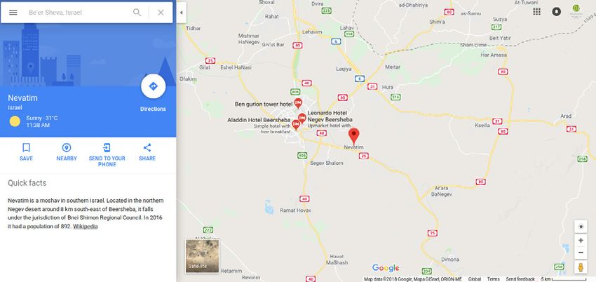
In Area C, 150 settlements have been established as of 2016, which are deemed illegal under
             Art. 49(6) of the IV Geneva Convention prohibiting “[t]he Occupying Power [from] deport[ing]
             or transfer[ing] its own civilian population into the territory it occupies” (Art. 49, IV Geneva
             Convention 1949). Such settlements are also in breach of Article 55 of the Hague Regulations,
             which state the obligation of the occupying power to safeguard occupied properties and
             maintain the status quo (Art. 55 Hague Regulations 1907). This internal fragmentation of the
             West Bank, which was intended to be temporary under the 1995 Oslo Interim Agreement,
             creates a system of movement restrictions enforced on Palestinians, as visually represented
             by UNOCHA’s interactive map of the occupied Palestinian territories (1). These movement
             restrictions directly violate the universal right to ‘freedom of movement’ as stated in Article
             13 of the Human Rights Charter. The ramifications of such restrictions include inadequate
             access to essential services and diminished economic activity. For example, in order to
             travel between different locations within Area A, it is necessary to pass through Area C or at
             least one checkpoint (Zahriyeh 2014). This is because Areas A and B are formed by numerous
             ‘islands’ within Area C.

             This fragmentation is further reflected in the colour-coded ID system enforced by the Israeli
             administration throughout all of Israel and the Palestinian territories. The colour and type of
             the ID determines the scale of movement restrictions and the legal jurisdiction that differs
             between ID types. Palestinians and Israelis residing within Israel have a blue Israeli ID, which
             allows movement throughout Israel and Area C of the West Bank. Although the same rules
             apply for Palestinians living in Jerusalem, they hold a specific Jerusalem ID that grants them
             ‘permission’ to reside there. This can be easily revoked by Israeli authorities. Palestinians
             in Gaza or the West Bank hold a green ID which allows movement only within the territory
             they live in. Permits are required to access other areas of the occupied territories or Israel.

             The two ID systems have the following dimensions: blue ID holders exist under Israeli civil
             law, in which they are considered innocent until proven guilty. Green ID holders are subject
             to Israeli military legislation, and are considered guilty unless they can prove otherwise
             (Alsaafin 2017). In the military court system, over 99% of cases are convicted (Military Court
             Watch 2016).

             Palestinian Villages Misrepresented or Missing
             on Google Maps
             There are 36 unrecognized Palestinian villages in the Naqab (Negev) desert in southern
             Israel (Nasasra 2018), and numerous unrecognized Palestinian villages in the West Bank’s
             Area C that are faced with a constant threat of demolition. These villages are not officially
             recognised by Israeli authorities, who systematically deny building permits to Palestinians
             in order to justify their illegality. The villages often lack basic services, which includes
             connection to the electricity grid and water supply, as well as infrastructure, health care
             and education (Jarzmik 2018). Israeli civil law applies to the villages located in the Naqab,
             and military law is enforced upon the villages inside Area C of the West Bank.

             (1) http://geomolg.ps/L5/Index.html?configBase=http://geomolg.ps/Geocortex/Essentials/REST/sites/A3/
                 viewers/V1/virtualdirectory/Resources/Config/Default

6 /   7amleh - Arab Center for Social Media Advancement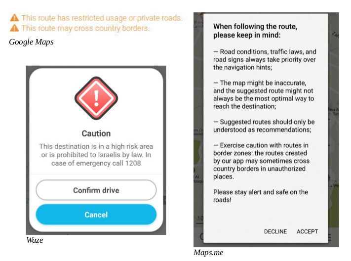
The Naqab – Palestinian Bedouins as Israeli Citizens Under Civil Law
There are in total 46 Bedouin villages in the Naqab, the majority of which existed before
Israel’s creation in 1948. Some claim to have existed since the 7th century. Israeli authorities
do not recognise Bedouin ownership of the land, and instead label them as ‘trespassers on
state land’ (Adalah 2018). The infrastructure and socio-economic living standards in these
Bedouin communities are among the lowest in Israel (Adalah 2018). The Prawer Plan (2011)
and the Memorandum of Law on the Regulation of Bedouin Settlement in the Negev (2016),
which approve the mass forcible transfer of over 70,000 Bedouins and the destruction
of their villages, have created an atmosphere where the threat of demolition and forced
evacuation is constant. In contrast, 70 Jewish farms in the Naqab have received recognition
from the Israeli authorities in order to sustain a Jewish majority population. (ACRI 2012;
ACRI, Bimkom, RCUV 2011; Swirski, Hasson 2006; Adalah n.y.; 2011; 20174; Arab Center for
Alternative Planning 2013; Bimkom 2014; Bimkom, RCUV 2012; Mossawa Center 2017).
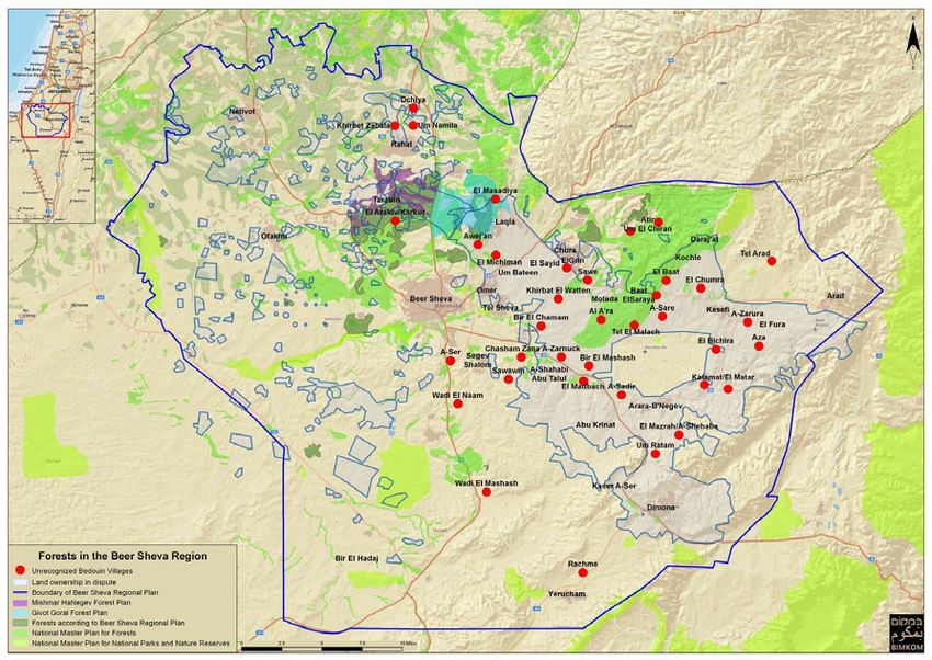
A method of enforcing the eradication of unrecognized Palestinian villages is to ensure their
misrepresentation on maps. As part of this policy, these villages do not appear at all on Israeli maps,
with the exception of army and hiking maps. Likewise, they do not appear on first sight on Google
Maps or at all on Israeli maps, with the exception of army and hiking maps. They are labelled on
NGO maps designed to increase their visibility. On Google Maps, the Bedouin villages are marked –
in contrast to cities and other villages – under their Bedouin tribe and clan names (Bimkom) rather
than with their village names and are only visible when zooming in very closely, but otherwise
appear to be non-existent. This means that when looking at Google Maps, these villages appear to
be not there, only when zooming on to a very high degree, do they appear with their tribe or clan
Image: Unrecognized Villages in the Naqab - Bimkom
Mapping Segregation - Google Maps and the Human Rights of Palestinians / 7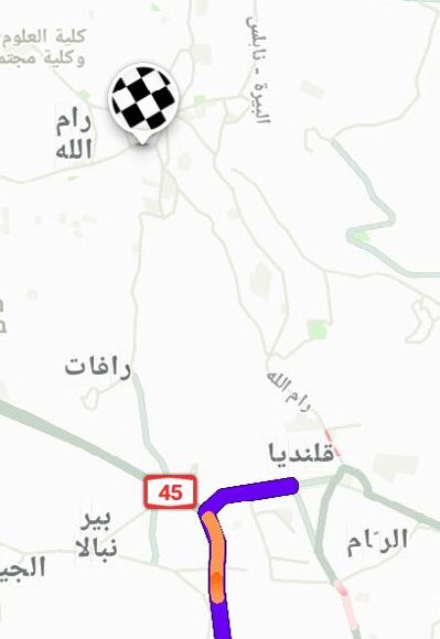
Screenshot (18th April 2018): Unrecognized Villages in the Naqab - Google Maps

             names. At first (and second and third) sight, therefore, these villages are simply not there.
             Despite their small size, Israeli villages are displayed even when zoomed-out, while
             unrecognized Palestinian Bedouin villages, regardless of their size are only visible when
             zooming in very closely.

             Screenshot (18th April 2018): Nevatim Israeli village visible on Google Maps despite low level of zoom

8 /   7amleh - Arab Center for Social Media Advancement
Basma Abu-Qwaider, Al-Zarnoooq village

  The village is not only not connected to basic services
  like water and electricity, forcing them to connect to
  private and thus much more expensive lines, or the public
  transport system, but also permanently faces demolition
  threats. Her brother’s home had been demolished, so the
  entire family helped to rebuild to provide him shelter. This
  cost them a lot of money.
  "Google Maps acts in a discriminatory manner towards
  the unrecognized village the same [way] as the Israeli
  government does. Google ignores the existence of these
  villages just like Israel and for me if you do not exist on
  the map it means that you are invisible and that’s exactly
  what Israel wants us to be."

Area C – Palestinians Under Israeli Military Law

Responsibility for land planning and zoning in Area C resides with the Israeli Civil
Administration (ICA), the power of which is centralised within the Israeli military (ACRI 2012,
Bimkom 2008). The Israeli zoning policy has only delegated 1% of Area C for Palestinians
to build on; building on the remaining 99% is prohibited (UNRWA n.y.). The Palestinian
Authority (2) Geomolg portal for spatial information in Palestine provides an interactive
map showing the building restrictions for Palestinians, which includes illegal settlement
boundaries, approved master plans, British Mandatory Plans, nature reserves, demolition
orders of 2017 and outlines Bedouin communities.

Between 2010 and 2014, only 1.5% of Palestinian building permit applications were
approved, forcing Palestinians to build structures illegally and risk demolition. In 2015,
11,000 demolitions of Palestinian buildings were ordered, impacting 149 Palestinian villages
in Area C (OCHA opt 2015, OCHA opt 2009). The ramifications of home demolitions and
planning policy in Area C of the West Bank are visualized in B’Tselems interactive map (3).

(2) http://geomolg.ps/L5/Index.html?configBase=http://geomolg.ps/Geocortex/Essentials/REST/sites/A3/
    viewers/V1/virtualdirectory/Resources/Config/Default
(3) https://www.btselem.org/map

                                          Mapping Segregation - Google Maps and the Human Rights of Palestinians   / 9
Raed Abu Judeh, Jiftlik, Jordan Valley

               “Jiftlik suffers from many problems caused by the
               occupation, people here are deprived from basic needs
               of the 21st century: water and electricity are big issues
               besides settler harassment. Whether we are on the map
               or not, the occupation wants us to leave by all means.
               The village doesn’t have a structural chart to define its
               borders, we cannot build and if we do, then we are under
               demolition threat.”
               The absence of a structural chart outlining the borders of
               the Jiftlik village, entirely located in Area C, means that it
               is under constant threat of demolition. When the village
               was first connected to the water network controlled by the
               Israeli company Makarot in 1982, around 1000 people were
               living in Jiftlik. Now, in 2018, the same amount of water is
               provided for the approximately 5000 villagers. Some parts
               of the village have been declared a ‘closed military zone’
               by the Israeli forces.

            Unlike Palestinian villages in the Naqab, some villages in the Jordan Valley in Area C are
            represented on Google Maps. While the Israeli settlements can be seen when looking at the
            larger area of the map, Palestinian villages are only visible when zoomed in, as a result of
            data provided and pressure by the NGO Bimkom (4). The settlements in the occupied West
            Bank appear on the map as being located within Israel, despite the fact that the term ‘West
            Bank’ also appears on the map.

            Screenshot (18th April 2018): Jordan Valley on Google Maps zoomed-out

            (4) http://bimkom.org/eng/

10 / 7amleh - Arab Center for Social Media Advancement
Screenshot (18th April 2018): Jordan Valley on Google Maps zoomed-in
International Law and Human Rights Law Perspective
The Israeli authority’s systematic refusal to issue building permits for Palestinians, denial
of official recognition of villages and continued demolitions constitute a violation of human
rights, including rights to land, resources, property, dignity and equality. Every Palestinian
has the right to adequate housing in accordance with the International Covenant on
Economic, Social and Cultural Rights (Art. 11 ICESCR, 1976), which was ratified by Israel in
1991. However, this basic human right is continually being denied by the Israeli authorities.
Whilst Palestinians in the Naqab have Israeli citizenship and are thus entitled to equal
treatment as Israelis under Israeli domestic law, Palestinians in Area C live under Israeli
military rule. Destruction of Palestinians’ property by the ‘Occupying Power’ is prohibited by
Art. 53 of the Fourth Geneva Convention (1949) unless “[…] absolutely necessary by military
operations”. This prohibition is routinely ignored.
In the Naqab and Area C, Israeli authorities are using strategies to forcibly transfer the
Bedouin communities, which are both direct, such as the enforcement of discriminatory
legislation, and indirect, such as the constant threat of demolitions. The aim of these
practices is to disposses and expropriate Palestinian land.
Israel’s refusal to officially recognise Palestinian villages in Area C as well as inside Israel, is
reflected in Google Maps’ representation of the area. The failure of Google Maps to depict
Palestinian villages on its maps suggests that their practices are politically influenced and
biased in favour of Israel’s systematic violation of the human rights of Palestinians.
Mapping Segregation - Google Maps and the Human Rights of Palestinians / 11Route Planning
The territorial fragmentation of the West Bank is exacerbated by the divided road system,
which places restrictions on Palestinian movement. 79 kilometres of so-called 'sterile'
roads are only accessible to blue ID holders (Israeli citizens with yellow car license plates)
and cannot be used by West Bank Palestinians (with green IDs). Palestinian presence on
these roads, which usually connect Israeli settlements, is illegal. The roads designated
for Palestinian use are often sub-standard non-paved or dirt tracks, which are sectioned
off from the Israeli roads with high fences and can be closed without prior warning by
Israeli forces. The consequences for Palestinians accessing Israeli-only roads include
arrest, delays, detainment, confiscation of cars, and even death. 155 kilometres of road
have restricted access for West Bank Palestinians, and often require special permits that
are very difficult to obtain. B’Tselem (5) and Ma’an Development Center (6) provide lists of
the location and length of these ‘sterile’ roads, partially prohibited and restricted roads
(B’Tselem 2004; Ma’an 2008).
These restrictions are further exacerbated by the maltreatment Palestinians receive at
checkpoints. The map above outlines the various movement restrictions for Palestinians on
foot and in vehicles, imposed via checkpoints. On roads shared by Israelis and Palestinians,
it is common for Palestinian cars, which are easily identified by their green licence plates,
to be delayed and searched frequently (B’Tselem 2004; Ma’an 2008).
There are potentially severe consequences for West Bank Palestinians who attempt to pass
through checkpoints into Israel or Israeli settlements within the West Bank. Therefore,
the need for accurate mapping and route planning services is immense. The movement
restrictions on Palestinians can have life-threatening consequences: West Bank Palestinians
have died at checkpoints after being denied passage by Israeli authorities (B’Tselem 2004).
Palestinians have also died at settlement entrances and bus stops after being shot by
Israeli soldiers under the pretext that they allegedly posed a threat (Brown 2014).
This section explains and compares the route planning applications Google Maps, Waze
and Maps.me, including how these apps name checkpoints and Israeli settlements. The
section also provides an analysis of route planning with the following five routes: (1) from
the central West Bank city of Ramallah to the northern West Bank city of Nablus, (2) from
Ramallah to the southern West Bank city of Bethlehem, (3) within the south Hebron Hills
rural communities in the West Bank: from the town of Yatta to the village of At-Tuwani, (4)
from Gaza to Haifa within Israel, and (5) from Gaza to Ramallah in the West Bank.
(5) https://www.btselem.org/
(6) http://maan-ctr.org/
12 / 7amleh - Arab Center for Social Media AdvancementImage: Israel’s System of Segregated Roads in the Occupied Palestinian Territories - Visualizing Palestine,
May 2012
Mapping Segregation - Google Maps and the Human Rights of Palestinians / 13Google Maps
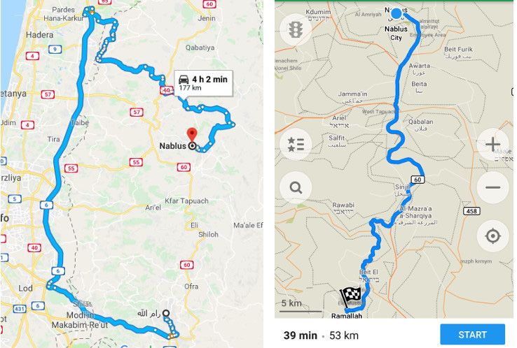
On routes within the West Bank, Google Maps prioritizes directing users through Israel rather
than through the West Bank, even if this adds considerable distance to the journey. The drive
from Ramallah to Nablus through the West Bank usually takes 45 minutes, however when
using Google Maps, the journey takes a long route through Israel and takes 4.5 hours. In
contrast, the shortest route from Ramallah to Bethlehem takes the driver through Jerusalem,
which is inaccessible for Palestinian West Bank ID holders. Whenever a route passes through
the West Bank, Google Maps shows two warnings on the route description: “This route has
restricted usage or private roads” and “This route may cross country borders” and fails
to highlight Israeli settlements or checkpoints. Google Maps is unable to calculate routes
within Palestinian rural communities, or to and from Gaza, displaying the message “Sorry,
we could not calculate driving/walking directions from x to y”. The app offers the option to
“add a missing place” and edit information, but this “might take some time to show up on
the map” as they must be reviewed first.
Screenshot (6th April 2018): Google Maps vs. Maps.me routing Ramallah - Nablus
Maps.me
While Maps.me does not mark Israeli settlements, it does have special markers for
checkpoints, which are marked as “checkpoints” with names such as “Israeli occupation
border_control” or by number, for example “Checkpoint 56”. However, routing goes through
checkpoints without clarifying the movement restrictions for Palestinian green ID holders.
When using Maps.me for the first time, a long general warning is displayed. All routes within
14 / 7amleh - Arab Center for Social Media Advancementthe West Bank and from Gaza to Israel or the West Bank can be calculated. Generally, routes
between Palestinian cities within the West Bank take the driver through the West Bank, with
the exception of Ramallah to Bethlehem, which is routed through Jerusalem. In the rural
communities in the South Hebron Hills, Maps.me displays a small dirt road that is used
by the Palestinian population in this area instead of the settler highway. Thus, Maps.me is
generally usable for Palestinian West Bank green ID holders. It also offers logged-in users
the option to add and edit locations based on the open-source OpenStreet Map (7).
Waze
Waze is an Israeli-developed app (Waze 2014) that is now owned by Google. The app works
within Israel and Area C, and includes warnings about traffic, accidents and police controls.
All directions given are exclusively within Area C and thus stop before entering major
Palestinian cities. For instance, when indicating a route to Ramallah, located in Area A, the
directions will abruptly stop at the checkpoint in Qalandiya. Only when the option to “avoid
high-risk areas” is switched off is it possible to plan routes that reach Palestinian cities.
When searching for Palestinian locations such as Bethlehem, primary suggestions with the
same name are all located inside Israel, and the Palestinian city of Bethlehem is located
further down the list. Before calculating routes within “high-risk areas” – Palestinian areas
– Waze displays a warning, including the number to call in case of emergencies, and
requires a user confirmation to start the route planning. Routes in rural Palestinian areas
and to or from Gaza are not possible, and instead an error message is displayed. Waze has
an “active community of online map editors who ensure that the data in their areas is as
up-to-date as possible” and offers logged-in users the option to “edit the map” and add
places and infrastructure such as roads (Waze n.y., Waze Support 2018).
Screenshot (6th April 2018): Route-planning to Ramallah
- Waze
(7) https://www.openstreetmap.org/#map=8/31.438/35.074
Mapping Segregation - Google Maps and the Human Rights of Palestinians / 15Comparison
None of the three route-planning apps analysed mark Israeli settlements as being illegal,
in accordance with Art. 49 IV Geneva Convention and Art. 55 of the Hague Regulations.
Maps.me is the only service that marks checkpoints on its maps, but it does not take them
into consideration when planning routes and navigating users. All three services display
a warning, different in length and specification concerning borders and accuracy of the
route. Waze specifically warns when entering a Palestinian area as a “high risk area” and
requires a confirmation to begin the route planning.
Screenshots (6th April 2018): Warnings given by the different applications
16 / 7amleh - Arab Center for Social Media AdvancementAll three mapping apps fail to take into account the movement restrictions and repercussions
for Palestinians when planning routes. The clearest example of this is the route between
Bethlehem and Ramallah. Google Maps takes the fastest route, which goes straight through
Jerusalem, thus crossing from the West Bank into Israel, then back into the West Bank, which
is only possible for blue ID holders and holders of foreign passports. The alternative routes
proposed by Google Maps also go through Israel. Maps.me takes the longer route which
avoids Jerusalem, and can be used by green ID holders (who are generally not allowed to
access Israel in their cars, and can only pass through checkpoints if they have an Israeli-
issued permit). This issue is illustrated in a video (8) showing an international passport holder
(who has no movement restrictions) and a Palestinian green ID holder attempting to reach
the same spot. Both Google Maps (9) and Waze (10) use the same platform for reporting errors on
maps and/or editing, suggesting edits and adding places to maps. The copyright information
on the lower left hand side of Waze’s Help Center is credited to Google.
The following table summarizes differences and similarities in the route planning of the
three different services. While on some routes, certain apps will direct the driver to routes
which are accessible and safe for West Bank Palestinians to travel on, there is no certainty
or guarantee with any of the apps that this will be the case. Even when a recommended
route is technically available to West Bank Palestinian drivers, they will still have to check
this route against current reality and consider it cautiously. This shows that the analyzed
mapping apps favour routes that can be used by blue ID holders, even inside the West Bank,
contradicting obligations under international human rights norms. As seen in the table,
Google Maps automatically calculates routes specifically for Israeli ID holders, and marks
neither checkpoints nor Israeli settlements.
(8) https://support.google.com/waze/answer/6262592?hl=en
(9) https://support.google.com/maps/answer/6391179?hl=en
(10) https://www.youtube.com/watch?v=4oE4jAsEPGg&feature=youtu.beviewers/V1/virtualdirectory/
Resources/Config/Default
Mapping Segregation - Google Maps and the Human Rights of Palestinians / 17Google Maps, Waze and Maps.me comparison on route-planning
within the occupied Palestinian territories and Israel
Google Maps Waze Maps.me
Illegal settlements x x x
marked as settlements
in accordance with
international law
Checkpoints named/ x x
marked
Warning when traveling
through Area A (under General warning, (confirmation General warning,
control of the Palestinian on every route- required each once at start
Authority) description time)
Warning when travelling x
through Israeli settlements
Routes passing through x/( )
Israeli settlements / blue- (rarely)
ID holder areas
Routes circumventing x/( )
Palestinian controlled (rarely)
areas (Area A)
Example-Routes:
Ramallah to Nablus / vice- Blue-ID holder / Routing Green-ID holder
versa (West Bank) not available stops before
Ramallah to Bethlehem / Blue-ID holder Palestinian Blue-ID holder /
vice-versa (West Bank) cities (unless green-ID holder
‘high-risk areas’
allowed)
Yatta to At-Tuwani / vice- Not able to Not possible Possible
versa (West Bank) calculate route (Routing Server (dirt-path)
Error)
Gaza Strip to Israel (Haifa) Through
checkpoints
(requires permit)
Gaza Strip to West Bank Through
(Ramallah) checkpoints
(requires permit)
18 / 7amleh - Arab Center for Social Media AdvancementTerminology and Availability
When the terms ‘West Bank’ and ‘Gaza’ disappeared from Google Maps in late 2016 and
were replaced with the general term ‘Israel’, an uproar on social media ensued. The hashtag
#PalestineIsHere went viral and reaffirmed the existence of Palestine – a term that had
never been used on Google Maps. Google offered an official apology for the deletion of
Gaza and West Bank, stating that a bug had caused this (Dent 2016). The hashtag has since
been used to advocate the existence of Palestine and its culture, and in early 2018 an
online petition to ‘put Palestine on the map’ reached 350,000 signatures (Change.org 2016).
Google Maps labels countries in bold black letters, and ‘undisputed international
boundaries’, with solid gray lines (Google Support n.y.). Israel is given a country label and
boundary. Jerusalem is clearly marked as the capital of Israel. The demarcation between
Israel and the West Bank and Gaza Strip is marked with a dashed line, which for the West
Bank is presumably along the Green Line, which Google says indicates ‘treaty and de facto
or provisional boundaries’ (Google Support n.y.). The border-marking appears to be the
same from both within the Palestinian West Bank and Israel. Google Maps’ different marking
of e.g. the Crimea (11) depends on whether the service is accessed from Russia or the Ukraine
illustrates how different perspectives can be included in a mapping service.
In Google Street View, most of Israel is available to view. However, in Gaza only a few places
are marked with photos, as is the case with other Palestinian cities in the West Bank.
Within the West Bank, the only places available on Street View are Israeli settlements, with
the exception of the Palestinian cities Jericho, Bethlehem and Ramallah. The majority of
Route 60 is also available. In Jerusalem, most of the Palestinian neighborhoods are left
out, however the Old City, which is located in illegally annexed East Jerusalem, is available
(Google Blog 2012).
Palestine was recognized as a ‘non-member observer state’ by the United Nations on 29th
November 2012 (UN 2012). Jerusalem was designated international status in UN General
Assembly Resolution 181 (II) on 29th November 1947 (UN 1947) and was only recently
recognized as the ‘undivided’ capital of Israel by the United States. President Trumps’
decision to recognize Jerusalem as the capital of Israel in December 2017 was strongly
condemned by the UN General Assembly (UN 2017) and was opposed by the majority of the
UN’s member states.
Through it’s mapping and labelling, one can deduce that Google Maps recognises the
existence of Israel, with Jerusalem as its capital, but not Palestine. The West Bank and Gaza
do not appear as part of any country or state, as Palestine is not labelled. The terminology
used by Google Search was changed in March 2013 from ‘Palestinian territories’ to ‘Palestine’
(MEMRI 2013), although the classification of Palestine doesn’t exist at all in Google Maps.
(11) https://www.npr.org/sections/thetwo-way/2014/04/12/302337754/google-maps-displays-crimean-border-
differently-in-russia-u-s
Mapping Segregation - Google Maps and the Human Rights of Palestinians / 19Screenshot (6th April 2018): Marking and terminology of borders and capitals in Israel and the occupied
Palestinian territories
20 / 7amleh - Arab Center for Social Media AdvancementScreenshot (6th April 2018): Availability of Street View in the Hebron area
Technological Feasibility and Google Maps
Alternatives
The Californian NGO The Rebuilding Alliance regularly holds ‘Map-Athons’ where
Palestinians and mapping experts add missing Palestinian villages, streets, and residential
and agricultural structures to Google Maps. In 2016, The Rebuilding Alliance and Bimkom,
another NGO, succeeded in making Google Maps add 236 missing Palestinian villages to
their maps (Rebuilding Alliance n.y.).
Unlike Google Maps, the Good Shepherd Engineering (GSE) PalMap (12) service provides
maps of the West Bank that show both Israeli settlements and Palestinian villages, as well
as marking checkpoints, refugee camps, and the separation wall. On their map of historic
Palestine, the separation wall is marked in different degrees of completion, with a colour-
coded system to mark settlements, Palestinian built-up areas, evacuated Palestinian
land, Israeli military bases, as well as the Areas A, B and C and the Green Line. GSE offers
a route planning app called iGoPalestine for smartphones, which focuses on guiding
Palestinians through the numerous movement restrictions they face. It also offers Street
Recordings, similar to Google Street View, for the Palestinian cities Bethlehem, Hebron,
Nablus, Ramallah, Jenin and Jericho. GSE depends largely on user subscriptions and fees.
Additionally, their ‘Palestine 1948’ (13) initiative allows users to locate information about
Palestinian villages and towns that were depopulated or destroyed during the 1948 Nakba
(‘catastrophe’, ethnic cleansing and displacement of Palestinians). Similarly, Palestine
Open Maps (14) uses historical maps of Palestine to illustrate depopulated villages or areas
destroyed from present official maps by combining emerging technologies with immersive
storytelling to bring to life stories of Palestinian displacement.
These different initiatives, illustrate how the absence of Palestinian villages on Google
Maps is not a technological issue, but rather a systematic omission. Despite countless
(12) https://palopenmaps.org/#/
(13) http://palmap.org/palestine1948/
(14) https://palopenmaps.org/#/
Mapping Segregation - Google Maps and the Human Rights of Palestinians / 21attempts, a Google Maps representative could not be reached to comment on this issue.
Although a few Google representatives initially agreed to answer questions about the issue,
in the end, none of the persons at Google were actually available to comment.
Conclusion & Recommendations
Google Maps does not include Palestinian areas that are unrecognised by Israel, or the
term ‘Palestine’, yet it features illegal Israeli settlements within the West Bank. It ignores all
movement restrictions that exist for Palestinians, such as checkpoints and restricted roads,
which impede free movement for Palestinians, and, if not taken into consideration can
cause severe danger for Palestinians. Route planning with Google Maps favours Israelis over
Palestinians, given that the default routes are often only accessible for Israelis. In its failure
to display checkpoints and restricted roads, and Palestinian villages in the same detail as
Israeli villages, Google Maps demonstrates its complicity in violating international law and
human rights agreements. Instead of aligning itself with the policies and practices of Israeli
authorities - or any one particular state - mapping services should operate in alignment
with human rights standards and international law. Google Maps, as the largest global
mapping and route planning service, has the power to influence global public opinion and
therefore bears the responsibility to abide by international human rights standards and to
offer a service that reflects the Palestinian reality. Instead of living up to this responsibility,
Google has adopted the Israeli narrative, and only rarely allowed for mapping of some
Palestinian cities in its Street View product.
Google’s Vision and Responsibility
In its company description, Google defines its goal as the following: “To organize the
world’s information and make it universally accessible and useful, through services that
can “[…] improve the lives of as many people as possible” (Google n.y., emphasis added).
According to this description, Google aims at universality rather than marginalisation. This
assumption can also be made from its slogan: “Not just for some. For Everyone.”(ebd.).
In a letter penned by Larry Page and Sergey Brin in 2004, they claim to “[…] provide
unbiased, accurate and free access to information for those who rely on [them] around
the world” (Page, Brin 2004, emphasis added), in order to add to “a well functioning
society” (ebd.) and “make the world a better place”. In the same document, it is stated
that “Google [...] has a responsibility to the world” (Page, Brin 2004).
Google, as part of the Global Network Initiative (GNI) is furthermore dedicated to an
upholding of international human rights standards, and in specific that "[i]f national
laws, regulations and policies do not conform to international standards, ICT companies
should avoid, minimize, or otherwise address the adverse impact of government
demands, laws, or regulations, and seek ways to honor the principles of internationally
recognized human rights to the greatest extent possible" (GNI n.y., emphasis added). By
completely adapting the Israeli government narrative, Google contradicts not only the
dedication to internationally recognized legal frameworks, but furthermore this guiding
principle of GNI.
22 / 7amleh - Arab Center for Social Media AdvancementGoogle and its services have become essential to everyday life across the globe. As it
provides these services, claims neutrality even though it has adopted a highly political
stance. Google openly acknowledges its responsibility to its customers, stakeholders,
and the world at large, yet Palestinians seem to have been left out of this pledge. This
discrimination against Palestinians is a clear contradiction of the values Google claims
to have, and its unwillingness to provide a true account of the reality in Palestine reflects
Google’s bias in favour of advancing the Israeli government’s agenda vis-a-vis Palestine.
Recommendations
Google Maps should:
Incorporate all ‘unrecognised’ Palestinian villages into its maps in the first layer
Provide the same level of detail in its representation of Palestinian villages in Area C
as it gives to Israeli settlements
Recognize and mark the illegality of Israeli settlements on its maps in accordance with
Art. 49 IV Geneva Convention and Art. 55 of the Hague Regulations
Clearly mark Areas A, B and C within the West Bank
Recognize all movement restrictions and restricted roads for Palestinians and clearly
display them
Name Palestine on Google Maps consistent with UN General Assembly resolution of
November 2012
Clearly distinguish routes which are only available to Israeli ID holders
Offer route planning for West Bank Palestinians which takes into account all restrictions
on movement
Recognize Jerusalem as designated international status in accordance with UN General
Assembly Resolution 181
Live up to its values, ideals and responsibilities and reflect them in all its services by
providing services in a non-discriminatory manner in accordance with the UN Guiding
Principles Reporting Framework
Engage in meaningful consultations with Palestinian civil society in order to discuss an
improvement of policies and services to meet the needs of Palestinians
Mapping Segregation - Google Maps and the Human Rights of Palestinians / 23Bibliography
ACRI – The Association for Civil Rights in Israel: What’s the Difference? Illegal Outposts,
Palestinian Towns in Area C, and Unrecognized Villages in the Negev, March 2012 (last
accessed 14th April 2018)
ACRI – The Association for Civil Rights in Israel; Bimkom – Planners for Planning Rights; RCUV
– The Regional Council for the Unrecognized Villages in the Negev: Policy Brief: Principles
for Arranging Recognition of Bedouin Villages in the Negev, June 2011 (last accessed 14th
April 2018)
Adalah – The Legal Center for Arab Minority Rights in Israel:
Israel’s destruction of Umm al-Hiran reminiscent of darkest of regimes such as apartheid-
era South Africa, April 2018 (last accessed 21st April 2018)
Israel Land Administration Law, in: Discriminatory Laws, September 20171 (last accessed
14th April 2018)
Jewish National Fund Law, in: Discriminatory Laws, September 20172 (last accessed 14th
April 2018)
Key Concerns Regarding the Human Rights of Palestinian Citizens of Israel, November 20173
(last accessed 14th April 2018)
Position Paper on “Prawer II”: The Israeli Government’s New Plan to Forcibly Displace and
Dispossess Palestinian Bedouin Citizens of Israel from their Land in the Naqab (Negev),
January 20174 (last accessed 14th April 2018)
The dangerous implications of the Israeli Supreme Court’s decision to allow the forced
displacement of Atir-Umm al-Hiran for the remaining unrecognized Bedouin villages in the
Naqab (Negev), updated February 2016 (last accessed 14th April 2018)
The Inequality Report. The Palestinian Arab Minority in Israel, March 2011 (last accessed
13th April 2018)
The Arab Bedouin and the Prawer Plan – Ongoing Displacement in the Naqab, n.y. (last
accesseed 14th April 2018)
Alsaafin, Linah: The colour-coded Israeli ID system for Palestinians, in: Aljazeera, November
2017 (last accessed 6th April 2018)
Arab Center for Alternative Planning: Prawer Plan – A fox hidden in sheep’s clothing (in
Arabic), November 2013 (last accessed 14th April 2018)
Bimkom – Planners for Building Rights:
The Prohibited Zone. Israeli planning policy in the Palestinian villages in Area C, June 2008
(last accessed 21st April 2018)
Why Is There no Development? Barriers to Development in the Recognized Bedouin Villages
in the Negev and Recommendations for their Removal, Executive Summary, August 2014
(last accessed 14th April 2018)
Bimkom; RCUV – The Regional Council for the Unrecognized Villages in the Negev: Alternative
Master Plan for the Unrecognized Bedouin Villages in the Negev, Abridged Version, 2012
(last accessed 14th April 2018)
Brown, Jonathan: The deadly errors of Google Maps directions in Palestine, in: Daily Dot,
August 2014 (last accessed 28th April 2018)
B’Tselem: Forbidden Roads. Israel’s Discriminatory Road Regime in the West Bank, August
2004 (last accessed 6th April 2018)
Military renews segregation on main street in Hebron, on: youtube, April 2015 (last accessed
27th April 2018)
Change.org: Google: Put Palestine On Your Maps!, 20th March 2016 (last accessed 12th May 2018)
24 / 7amleh - Arab Center for Social Media AdvancementDent, Steve: Google explains why Palestine isn’t labeled in Maps, in: engadget, October 2016
(last accessed 12th May 2018)
GNI: GNI Principles, n.y. (last accessed 12th September 2018)
Google: Our company, n.y. (last accessed 12th May 2018)
Google Blog: Exploring Jerusalem’s Old City streets with Street View, April 2012 (last accessed
12th May 2018)
Google Support: Google Maps Help – Understand country borders and names, n.y. (last
accessed 4th May 2018)
Jarzmik, Oscar: By Failing to “Recognize” Bedouin Villages, Israel Continues to Dispossess
Palestinians, in: Muftah, June 2017 (last accessed 13th April 2018)
Ma’an – Development Center:
Apartheid Roads. Promoting Settlements. Punishing Palestinians, December 2008 (last
accessed 6th April 2018)
Herding Communities, 2012 (last accessed 21st April 2018)
Moving Nowhere. Firing Zones and Forcible Transfer in the Jordan Valley, 2015 (last accessed
21st April 2018)
MEMRI: Google Recognizes Palestinian State, May 2013 (last accessed 4th May 2018)
Military Court Watch: Background: Trial, updated August 2016 (last accessed 6th April 2018)
Mossawa Center – for Arab Palestinian Citizens in Israel:
The Mossawa Center’s Analysis of the Government State Budget 2012, n.y. (last accessed
14th April 2018)
The Palestinian Arab Bedouin Naqab-Negev, May 2017 (last accessed 14th April 2018)
Nasasra, Mansour: Back to the Lost Land: The ongoing struggle for recognizing the rights of
the Arab Bedouin in Bi’r al Saba’ and Naqab region, in: Mustafa, Mohanad (edt.): 70 years of
Nakbah, Mada al-Carmel, 2018
OCHA opt – United Nations Office for the Coordination of Humanitarian Affairs, occupied
Palestinian territory:
Restricting Space: The Planning Regime Applied by Israel in Area C of the West Bank,
December 2009 (last accessed 20th April 2018)
Under Threat: Demolition orders in Area C of the West Bank, September 2015 (last accessed
20th April 2018)
Page, Larry; Brin, Sergey: “An Owner’s Manual” for Google Shareholders, Founders’ IPO
Letter, 2004 (last accessed 12th May 2018)
Palestinian Freedom Riders: Press Release: Palestinian Freedom Riders On Their Way to
Jerusalem Violently Arrested on Israeli Settler Bus, November 2011 (last accessed 27th April
2018)
PCBS – Palestinian Central Bureau of Statistics: Number of Settlements in the West Bank
by Governorate and Type of Settlement, 2017 (last accessed 27th April 2018)
Rebuilding Alliance: Advocate – Mapping Matters, n.y. (last accessed 4th May 2018)
Swirski, Shlomo; Hasson, Yael: Invisible Citizens: Israeli Government Policy Toward the
Negev Bedouin, Executive Summary, Adva Center, February 2006 (last accessed 14th April
2018)
United Nations:
General Assembly demands all States comply with UN resolutions regarding status of
Jerusalem, December 2017 (last accessed 4th May 2018)
Mapping Segregation - Google Maps and the Human Rights of Palestinians / 25General Assembly Resolution 181 (II). Future government of Palestine, 29th November 1947
(last accessed 4th May 2018)
General Assembly Votes Overwhelmingly to Accord Palestine ‘Non-Member Observer State’
Status in United Nations, November 2012 (last accessed 4th May 2018)
UNRWA – United Nations Relief and Works Agency for Palestine Refugees in the Near East:
Demolition Watch, n.y. (last accessed 20th April 2018)
Waze: About Us, n.y. (last accessed 12th May 2018)
Waze: Terms of Use, September 2014 (last accessed 4th May 2018)
Waze Support: Fix a map issue, 2018 (last accessed 12th May 2018)
Zahriyeh, Ehab: Maps: The occupation of the West Bank, in: Aljazeera, July 2014 (last accessed
6th April 2018)
26 / 7amleh - Arab Center for Social Media AdvancementMapping Segregation - Google Maps and the Human Rights of Palestinians / 27
7amleh
         Arab Center
         for Social Media
         Advancement

       Contact us:
       info@7amleh.org | www.7amleh.org
       Tel: +972 (0)774020670
       Follow us on Social Media: 7amleh

28 / 7amleh - Arab Center for Social Media Advancement
You can also read