Mapping the planet Mars - Planetary exploration
←
→
Page content transcription
If your browser does not render page correctly, please read the page content below
Planetary exploration Spaceflight Vol 47 July 2005
Mapping the planet Mars
by Philip Corneille
Ancient Babylonian clay tablets
depicted the Earth as a flat circular disk
but both Roman, Greek and Arab
empires’ cartographers were more
interested in producing celestial globes
rather than terrestrial. The first
terrestrial globe was produced by
Crates of Mallos, around 150 BC, and
the earliest surviving Earth globe was
produced by Martin Behaim in 1492.
However, it lasted until the 20th century
when the first photos of Earth from
space to produce the most accurate
terrestrial globes. Since then mankind’s
Lowell observatory – Flagstaff Arizona
attention has turned to the planets.
Mars before the space age
The planet Mars, named after the Roman
god of war, is fourth in order of distance from
the Sun and seventh in order of size and
mass. The astronomical symbol for Mars,
represents a shield with a spear. The so-
called red planet is slightly more than half
the size of Earth but the lack of oceans gives
it the same landmass as Earth. Mars has no
plate motion and its rotational axis is inclined
to the ecliptic, like Earth’s. The planet
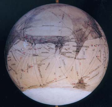
Mars globe (top) made by
completes an elliptical orbit around the Sun
Percival Lowell in 1911,
in 687 days and spins on its axis with a
based on his observations. It
period of 24 hours 37 minutes. This period is shows the ‘canals’ in the
named a ‘sol’ or Martian solar day. It has two area of Elysium planitia and
moons, Phobos (Fear) and Deimos (Terror), Utopia planitia and (above)
named after the mythical chariot horses of Mars photo-frames show the
Mars. The inner moon, Phobos, is already areas covered by the 1969
within the ‘Roche limit’ where internal gravity fly-bys of Mariner 6 and 7.
alone is insufficient to hold it together. NASA/JPL
Phobos could conceivably become a ring
plane around the Mars within the next 50
million years.
Galileo Galilei made the first telescopic
observations of Mars in 1610. Another Italian
astronomer, Francesco Fontana, produced
the earliest drawings that showed markings
on the disk of the planet. Unfortunately, Johann von Mädler in 1830. It featured a Schiaparelli is usually credited with their first
these markings bear no resemblance to the system of longitude and latitude, not too description.
planetary features known today, so the different from today’s coordinate system. However, the idea of ‘canals’ might have
Dutch scientist/astronomer Christiaan In 1877, the American astronomer Asaph originated in the work of the Italian
Huygens was credited with the first accurate Hall discovered Mars’ two tiny moons and astronomer Angelo Secchi of the Vatican
drawings with surface details of Mars (1659). the Italian astronomer Giovanni Schiaparelli observatory (1868). When Schiaparelli had
In 1666, the Martian polar caps were first produced the first modern map of Mars, to abandon his observations, a wealthy
noted by Giovanni Cassini, who also which contained Latin nomenclature in terms Boston aristocrat, Percival Lowell, decided to
calculated the rotation period of the red of the ancient geography of the continue the work and set up an observatory
planet. Mediterranean area in biblical times. The atop ‘Mars hill’, Flagstaff, Arizona in 1894.
The very first map of Mars was made by map showed indications of grooves or The dedicated amateur astronomer was
German astronomers Wilhelm Beer and channels on the bright areas and convinced that the ‘canals’ on Mars were
270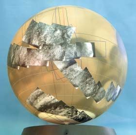
Planetary exploration

built by an intelligent civilization on the red
planet.
   Lowell made maps and Mars-globes
based on his 15 year long observations and
published his views in three books: ‘Mars’
(1895), ‘Mars and its canals’ (1906) and
‘Mars as the abode of Life’ (1908). Although
controversial, Lowell’s maps were widely
used until the 1950s when photographic
advances were hoped to resolve some
differences but even photographs were
subject to interpretation. It lasted until 1958
for the International Astronomical Union
(IAU) to adopt a formal list of place-names
on Mars related to a Mars-map by Glauco de
Mottoni, which was based on a large number
of photographs taken by the French
astronomer Henri Camichel at the Pic du
Midi observatory.
   Confidence in visual observation
remained strong until telescopic views of
Mars were replaced by high-resolution space
probe images. Finally in July 1965, the
                                                  Three large four foot diameter photomosaic globes are completed with Mariner 9 pictures. Each
Mariner 4 fly-by ended an era of Mars
                                                  picture underwent many stages of computer processing and photographic printing.          NASA/JPL
studies limited to Earth-based observations.
                                                  The Mariner 9 photomosaic Mars globe showing the consistency of the tone and contrast of the

Mars-mapping from spacecraft                      photographs. A specially designed protractor that swivelled around the poles was used to locate
                                                  each picture.                                                                            NASA/JPL
NASA’s Jet Propulsion Laboratory (JPL)
Mariner Mars project started the initial
exploration of Mars when the Mariner 4 fly-by
provided the first views of the Martian
surface (see page 270). The Mariner 4
television experiment showed cratered
terrains and proved to be historic and
scientific significant but the pictures could
not contribute to a clear understanding of
transient features.
   The 1969 fly-bys of Mariner 6 and 7
returned about 200 times the picture data of
Mariner 4 and these probes also provided
low-resolution coverage of the entire planet
by acquiring full disc views of Mars using the
high-resolution camera before close-
encounter. However, these remarkable far-
encounter global photographs were
insufficient to create an accurate complete
globe of the red planet.
   Altogether, the Mariner 4, 6 and 7 fly-bys
only photographed 10 percent of the surface
of Mars. A complete mapping of the red
planet was performed by the Mariner 9
spacecraft, which went in orbit around the
planet in November 1971. The spacecraft’s
mission was to map 70 percent of the
surface of Mars during 90 days in orbit but
Mariner 9 remained operational for 349 days
and mapped the complete surface of Mars. It
also photographed the Martian moons
Phobos and Deimos.
  After nearly one year of operation,
Mariner 9 returned 7300 photos, which

                                                                                                                                               271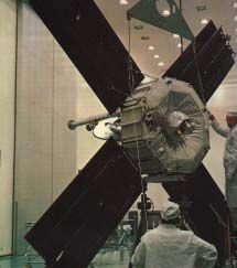
Planetary exploration                                                                                Spaceflight Vol 47 July 2005

                                                                                                     Mariner 4 –
                                                                                                     During the November 1964 launch
                                                                                                     window to Mars, both Russia and
                                                                                                     America sent unmanned spacecraft
                                                                                                     to the red planet. After the Russians
                                                                                                     lost contact with their Zond-2 in
                                                                                                     April 1965, it was the American
                                                                                                     Mariner 4 which, in July 1965,
                                                                                                     became the first interplanetary
                                                                                                     spacecraft to successfully flyby
                                                                                                     Mars and send back photos.

                                                                                                     Mariner 4 spacecraft
                                                                                                     NASA approved the Mariner-Mars
                                                                                                     project in November 1962 and the Jet
                                                                                                     Propulsion Laboratory (JPL) started to
                                                                                                     build the twin Mariner 3 and 4
                                                                                                     spacecraft. These were based on
                                                                                                     Mariner 2 but with four solar panels.
The two large four foot diameter globes being produced based on the 1971 Mariner 9 mapping              The 261 kg Mariner 4 carried seven
pictures. Mariner 9 circled Mars 698 times and returned 7300 photographs.             NASA/JPL       scientific instruments, most of which
                                                                                                     were mounted on the outside of the
revealed a planet beyond speculation. The         a 6-foot diameter globe for the von Karman         frame, a Helium magnetometer, a solar-
images showed astonishing geological              auditorium of the JPL campus in Pasadena,          plasma probe, a trapped radiation
features such as giant volcanoes, plateaus        California. Completed in September 1973,           detector, a cosmic ray telescope, a
and the largest canyon in the solar system,       these globes showed large-scale geologic           micrometeorite detector, an ionisation
named “Valles Marineris” in honour of its         features with a perspective that scientists        chamber and Geiger-Muller tube to
discoverer.                                       couldn’t obtain on flat projections.               measure radiation.
   More surprisingly, after computer                 The next generations of spacecraft sent            Last but not least, Mariner 4 was
processing of the digital TV images, subtle       to Mars had cameras (vidicons) with vastly         equipped with a television camera
details such as the relics of ancient             improved capabilities. The 1976 Viking             capable of taking 22 black-and-white
riverbeds and gullies were revealed in the        orbiters photographed 95 percent of the            photographs through a small
landscape of this seemingly dry and dusty         surface at a resolution of 200 metres. The         Cassegrain telescope mounted on a
planet. These enhanced high resolution            1997 Mars Global Surveyor orbiter cameras          scan platform at the bottom centre of
photographs enabled JPL to produce the first      made wide-angle images of the Martian              the spacecraft.
photo-mosaic globes of a planetary body.          surface and data from the spacecraft’s laser
   The task of planning and supervising the       altimeter have given scientists their first 3-D    Eight month journey
mosaicing of the four-foot globes was             views of Mars’ north polar ice cap. The 2001       After two years of preparation, Mariner 3
assigned to Elmer Christensen, who                Mars Odyssey’s camera system obtained the          was launched on 5 November 1964 by
designed the protractor to precisely locate       most detailed complete global maps of Mars         an Atlas-Agena. However, about 50
the images on the sphere. Each Mariner 9          ever, with daytime and night time infrared         minutes into flight, the spacecraft
mapping picture was produced in one of            images at a resolution of 100 metres.              unsuccessfully attempted to deploy its
three projections: ‘Mercator’ for the                The 2004 Mars Express high-resolution           solar panels and eight hours later the
equatorial latitudes, ‘Polar stereographic’ for   stereo camera is capable of 10 metre per           spacecraft battery ran out of power. A
the polar regions and ‘Lambert’ for the           pixel resolution and the reconnaissance task       later investigation indicated that the
intermediate regions. The JPL team carefully      is to observe half of the surface at this          cylindrical fibreglass-honeycomb nose
positioned 1500 photographs on the globe.         resolution and 1 percent of the surface at 2       fairing, designed to protect the
   Known variations in the Mariner 9 camera       metre per pixel resolution.                        spacecraft during launch and ascent,
response were removed, along with                    After 40 years of reconnaissance,               failed to be jettisoned, a problem solved
geometric distortions and reference marks.        exploration and intensive study it certainly       before the end of the Mars launch
Surface detail enhancement allowed ridges         seems that mankind is ready to make the            window. The Atlas-Agena launch vehicle
and craters to be seen with equal clarity in      dream of a human mission to Mars come              had been fitted with a complete new
the dark regions and on the bright polar          true.                                              magnesium fairing, constructed in record
caps. The completed four foot globe was                                                              time by the JPL engineers, and Mariner 4
                                                  The author thanks Lowell observatory in
sprayed with a clear coating to protect the       Flagstaff – Arizona for the Lowell globe picture   was launched on 28 November 1964.
surface. The original globe was re-               and Russell Castonguay of Anteon for                  This time the launch procedure was
photographed in 452 roughly rectangular           providing the NASA-JPL Mariner 9 globe             successful and the restartable Agena
segments, which allowed the construction of       photographs.

272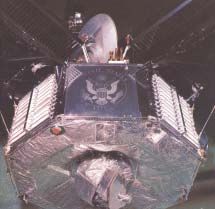
Planetary exploration

the first flyby of Mars
 stage put the spacecraft on course to the     for nine hours. Then the CC&S turned off
 red planet. A single midcourse correction     the cruise science and began the
 was made on 5 December 1964 to ensure         playback mode, in which engineering
 that the probe would pass within 10,000       telemetry would alternate with playback
 km of the planet’s surface. The 1964          of the TV pictures data.
 Mariner Mars spacecraft was the first            On 15 July, JPL received the first
 space mission to use a star (canopus) as      signals. The 22 photographs stored on
 a navigational reference object as, during    magnetic tape were transmitted to Earth
 its flight, Earth would transit across the    at a speed of eight bits per second. Each
 face of the Sun.                              image had a size of 250000 bits, so it took
    April 1965 was a period of records –       nine days before the full set arrived at the
 Mariner 4 broke both the record of            Pasadena centre.
 continuous operation (129 days                  Mariner 4’s pictures comprised of 200
 previously set by Mariner 2 to Venus) and     TV lines with 200 picture elements per
 the record for long-distance radio            line, each represented by 64 shades of         Radio-tests on the Mariner IV spacecraft.
 communications (62 million miles              grey from white (0) to black (63).             Compare the size of the craft against the
 previously set by Zond-1 to Venus). En        Afterwards the photographs were                JPL-engineers.          Photos: NASA/JPL
 route to Mars, the unmanned spacecraft        computer-enhanced by stretching the
 detected the effects of solar flares and      intensity values in order to make feature
 measured cosmic radiation.                    identification easier.
    By 7 July, Mariner 4 had entered the          The first, historical image showed 350
 gravitational field of Mars and four days     km of the 15,000 km far Martian limb at
 later it was only one million miles away.     about 40° North latitude.
 On 14 July 1965 the signal was sent to           The most significant finding from the
 aim the cameras at the Martian surface        22 close-up Mariner 4 photos was the fact
 and Mariner 4 began photography when          that Mars appeared much more Moon-like
 the spacecraft was 9000 km above Mars’        than Earth-like as the surface was heavily
 surface.                                      cratered. More than 70 craters appeared
    The television subsystem worked            in the Mariner 4 pictures.
 correctly, filled its magnetic tape with 22     Although the spacecraft couldn’t give
 pictures, shut itself off and ordered the     any definite data on the possibility of
 telemetry system into cruise mode in          extra-terrestrial life forms on Mars, from
 order to activate the science instruments.    the data returned by the spacecraft’s
    One of the great achievements of the       instruments scientists concluded that no
 Mariner 4 mission was the modification of     form of life existed.                          Side-view of Mariner IV clearly showing the
 mission plans while the spacecraft was in       Mariner 4 was not expected to survive        TV camera underneath the octagonal
 transit in order to accommodate certain       much longer than the eight months after        structure. The ‘Venetian blinds’ on the
 science experiments. The mission had          its flyby, but actually lasted about three     sides were used for internal temperature
                                                                                              control.
 been designed to occult Mariner 4 behind      years in solar orbit, continuing long-term
 the planet so that the effects of the         studies of the solar wind environment
                                                                                              Mariner IV is being readied for its
 Martian ionosphere and atmosphere on          and making coordinated measurements
                                                                                              historical mission to Mars in 1964.
 the spacecraft’s radio signals could be       with Mariner 5, a sister ship launched to
 observed. Not only did the experiment         Venus in 1967.
 indicate surface pressures of 4.1 to 7.0         The 1965 flyby of Mars emphasised the
 mbar but it also confirmed the benefits of    exploratory potential of space
 maintaining some flexibility in mission       photography. Although only one percent
 plans even after a spacecraft is launched.    of the Martian surface was pictured, and
 The close flyby of the Mariner 4              the photos returned by Mariner 4 dashed
 spacecraft past Mars, combined with the       the hope of finding life forms on Mars,
 accurate tracking of the spacecraft on its    scientists convinced NASA to conduct a
 trajectory, allowed improvements in the       more thorough exploration with orbiting
 calculation of the planet’s mass. Mariner     missions. The greatly improved images of
 4’s magnetometer discovered no                Mariner 9 (1971) led to the revitalisation
 magnetic field and the spacecraft             of interest in Mars as a place where life
 continued sampling the space                  might have harboured at some time, if not
 environment just outside the orbit of Mars    in the present.

                                                                                                                                       273
Planetary exploration Spaceflight Vol 47 July 2005 274
You can also read