MAPPING THE RISK OF FOREST FIRES IN ALGERIA: APPLICATION OF THE FOREST OF GUETARNIA IN WESTERN ALGERIA - SCIENDO
←
→
Page content transcription
If your browser does not render page correctly, please read the page content below
Ekológia (Bratislava)                                                           Vol. 37, No. 3, p. 289–300, 2018
                                                                                       DOI:10.2478/eko-2018-0022

Mapping the risk OF FOREST FIRES in Algeria:
application of the forest of Guetarnia in
western Algeria
BENAMAR BELGHERBI1, KHELOUFI BENABDELI1, KAMEL MOSTEFAI2
1
 Research Laboratory in Geo-Environment and Spaces Development, Faculty of Science of Nature and Life, Univer-
  sity of Mascara, Mascara 29000, Algeria, BP 305 Sidi Said University of Mascara 29000, Algeria; e-mail: benamar_
  cum@yahoo.fr benabdeli_k@yahoo.fr
2
 Forest Conservation of Mascara, Algeria; e-mail: k.mo@live.fr

                 Abstract

                 Belgherbi B., Benabdeli K., Mostefai K.: Mapping the risk forest fires in Algeria: Application of
                 the forest of Guetarnia in Western Algeria. Ekológia (Bratislava), Vol. 37, No. 3, p. 289–300, 2018.

                 The methods applied in Algeria for the prevention and fight against the fires remain fairly tradi-
                 tional and have proved to be ineffective in reducing the disastrous impact of this phenomenon.
                 However, the aim of this work is to analyse a forest ecosystem that is fairly representative of the
                 whole of the forests in Algeria, on plan risk and vulnerability of the environment for a better con-
                 trol of risk. Using modern geomatics techniques to map the degree of risk of fires and analysis the
                 space: like satellite imagery spatial data and Geographic Information Systems (GIS).The Guetarnia
                 forest in western Algeria has been retained; seven thematic maps have been developed and have
                 helped to develop a sensitivity map to depict the fire risk.

                 Key words: forest fires, map risk, remote sensing, GIS, Guetarnia (Algeria).

Introduction

Each year, several million hectares were burnt at the global scale in the Mediterranean basin.
It is estimated that 6000,000 to 8000,000 ha are annually destroyed by fire, especially in the
countries of the northern shore of the Mediterranean (Rowell, Moore, 2000; Carrega, 2008;
Hansen et al., 2013). However, the forest of Algeria is typically Mediterranean terms of its cli-
mate, terrain, composition and structure; it is very sensitive to fire. Over the centuries, it has
witnessed various degradations, while they were flourishing at the Carthage and Roman eras,
and even after the invasion of Arabs (De Ribbe, 1866; Trollard, 1893). The forest heritage of
Algeria is in perpetual degradation; it is an area estimated at 5 million ha during the colonial
period (Boudy, 1948) that has extended to 1,492,000 ha (FAO, 2013). The forest area was
reduced, during the colonial period (1830−1962), to 2,400,000 ha (Boudy, 1948; Berchiche,
1968; Sari, 1978; Rebai, 1983). An average of 18,182 ha is burned annually.
     In the MENA (Middle East and North Africa), Algeria represents the country most af-
fected by forest fires in percentage of travelled surface. For a country highly threatened by de-
sertification, it has avery low rate of forestation estimated at 1.76% (FOSA, 2000; Nedjraoui,

                                                                                                               289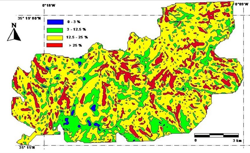
2003). The analysis of data from the Directorate General of Forests (DGF) pointed out that
during the period 1963−2014, the area affected by forest fires was in the order of 1,770,800
ha, or an average of area travelled per year of 35,000 ha/year (DGF, 2014).
     The current situation reflects Algeria’s weak ability to control the forest fires phenom-
enon and this is due to several reasons: the lack of a database relating to fire, ignorance of
the causes, lack of silvicultural work, aging infrastructure that is most of the time archaic
and dilapidated, an absence of vision of management even in the short term; to this should
be added a technical staff that is far from any progress in terms of training and current tech-
niques for combating the fires of forests.
     The Guetarnia forest is a fair representative of the forests of the country; it is semi-arid,
has registered area of 624,286 ha, was burned during the period from 1903 to 1922, and has
an annual average of area covered by the fire of 31.02 ha/year. The analysis of the current pe-
riod (1981−2014), allows seeing that the average of area burned annually is 250 ha on a total
of 7,127,707 ha. The resurgence of fires is clearly confirmed since the annual mean surface
area burned has increased from 31 to 250 ha.
     Furthermore, the risk assessment of forest fires has been the main topic of several research
papers, and fire is the most redoubtable and most devastating factor that can cause damage to
the forests of Algeria (Leutreuch, 1982; Benabdeli, 1996; Madoui, 2002; Arafa, 2008; Terras et
al., 2008; Khader et al., 2009; Mohamed et al., 2011; Berrichi et al., 2013; Borsali et al., 2014;
Meddour et al., 2014; Meddour, 2015). Despite this worrying fact; there is no national strat-
egy focused on mapping the fire risk in order to put in place a plan of prevention is business.
Finally, the objective of this study is to use the modern technique geomatics, (GIS), in order
to assess the risk of forest fires on the one hand and to put at the disposal of managers a set of
adapters that can be used in order to propose a solution for the prevention and management
of the forest fire risk. The Guetarnia forest has been chosen, as it brings together the major-
ity of the ecological characteristics and socio-economic of forest ecosystems, to achieve the
objectives of the environment for a better control of risk.

Material and methods
Ecological characterization of Guetarnia forest

The forest of Guetarnia is located in the north-westerern Algerian region (Fig. 1) and is part of the mountains of Beni-Chou-
grane. Guetarnia is localized between longitude 0°00 and 0°30’E and latitude 35°00’ N and 35°30’ N with an area of 10,140.12
ha, and also focused between two wilayas, wilaya of Mascara with a surface area of 2,818.82 ha and wilaya of Sidi-Belabbes
with 7,321.30 ha. The forest of Guetarnia presents a rugged topography of mountains and foothills with altitude soscillating
between 411.8 and 813 m inducing a class of slope between 15 and 30% with more than 55% (Belgherbi, 2002).
     The facies lithology is represented by a substrate of origin Miocene and Cretaceous constituted by elements generally soft
and eroded. The substratum Miocene is covered everywhere by the quaternary formations: calcareous crusts, sandy clays and
sands. The soils are sandy clay to sandy (Dalloni, 1940, 1953). This type of ground limestone, generally low depth (between 30
and 40 cm), belonging to the class of redziniferes soils and calcareous brown (Dalloni, 1940, 1953; Belgherbi, 2002).
     The forest falls within the bioclimatic floor semi-arid to temperate variant with an average annual precipitation of 350
mm. Two periods characterize this region: a cold season between November and April, recording the minimum of less than
3 °C and a hot season from May to October with the maxima of 35 °C.
     The vegetation, Mediterranean-type sclerophyllous, is characterized by arecovery of the order of 45% with a composi-
tion dominated by three species: the Pinus halepensis Mill, Tetraclinis articulate Vahl and Quercus rotundifolia L. The first two
species occupy more than 65% of the acreage and are pyrophytes with a high combustibility and flammability. The stratum

290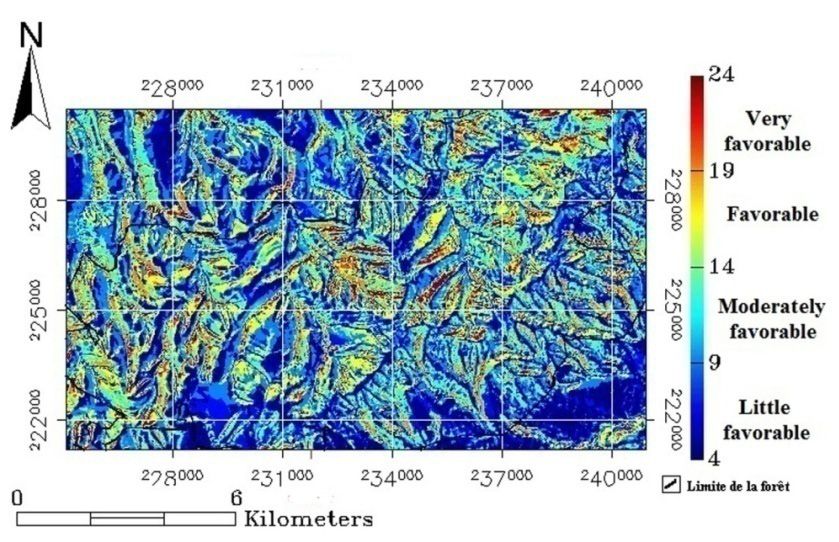
shrubby and bushy is represented primarily by the
Rosmarinus, Phillyrea and the Chamaerops humi-
lis (Souidi et al., 2010).

Methodology

The establishments of the map of vulnerabil-
ity of forests to fires in fact appeal to the ap-
plication of a model established by (Dagorne,
Duche, 1994) and tested on the mountain-
ous forest of the Mediterranean region. The
different steps of the methodology adopted
throughout in this work are represented by the
flowchart synthesized in Fig. 2.
     The basic data for these formulas, exploited
by a series of specialized software, allow the es-
tablishment of different maps (layers of useful
information); these last few are going to be the
subject of superposition in order to put in place
the map from the fire risk. The tools implement-
ed for the development of the map of the fire risk
are ENVI 3.4 and MAPINFO 7.0. The latter has           Fig. 1. Location of the forest of Guetarnia.
been used for the establishment of the digital ter-
rain model (DTM) and for obtaining the map of
slopes, exhibitions and the topomorphology.
     The ENVI (Environment for Visualising
Images) has been used to process the images,
enabling the visualization and analysis of data.
Its functionality resides in the fact that it con-
tains a library of algorithms, includes functions
for transformation of data, filter functions as
well as functions of classification.

Fire risk modelling

To evaluate the fire risk, it is necessary to model
each element of risk, three main factors for the
assessment of risk of forest fires such as the fuel,
the topomorphology and human activities. The
index that has interested us in this work is given
by formula (1) proposed by (Dagorne, Duche,
1994). The principle of risk estimated by this
formula is based on the product of hazard and
vulnerability.

     IR = 5.IC + 2.IH + IM                      (1)

where: IR is Risk index; IC is index of combus-
tibility; IM is Topo-morphological index; IH is
index of human activities.
      Based on the principle of weighted sum,
this index is designed as a model assigning each
parameter a weighting coefficient based on its
influence on the spread of fire.                       Fig. 2.Graph of establishment process of GIS.

                                                                                                       291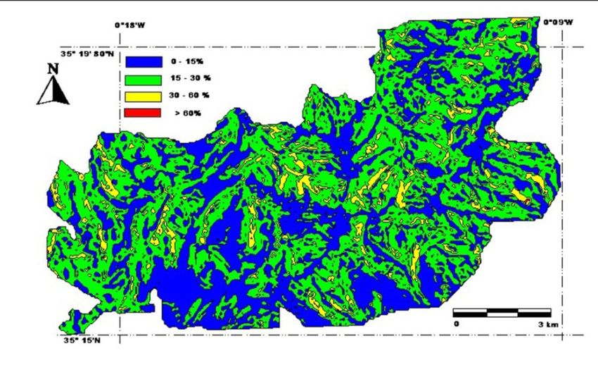
The characterization of this index is based on the spatial variability of the risk of fire whose determination is the
outcome of the physical parameters involved in the model chosen (Keaneet al., 2010).
    In the proposed model, index topo-morphologic (IM), three topographic parameters were involved: slope, ex-
posure and altitude. These settings are deducted from the digital terrain model (D.T.M.) in the region. This index is
expressed by the following relationship:

    IM = 3p + e.m .			                          (2)

where: p is slope; m represents morphology of area; e is exposure.
      To evaluate the index of combustibility (IC), the method proposed by (Putri et al., 2016) to estimate the poten-
tial severity of a fire starting in a forest stand determines has been retained. This method consists of, in the develop-
ment of a model, empirical data, based on the experience of the fire brigade to weight the terms of a mathematical
expression whose parameters are from a standardized description of the vegetation (Keane et al., 2010).
      Among the parameters reflecting the susceptibility of the vegetation to fire is the type of fuel available (horizon-
tal stratification and vertical), that is, the phytomasse. This is an important factor in the emergence and spread of
fires (Dagorne, Castec, 1992; Mariel, 1998).
      The index of combustibility or intensity index of potential fire is expressed by the following relationship:

    IC = 2.4BV(e1 + E2 - 7.18) + 39             (3)

     where: BV is the biovolume of the plant formation; e1 is the note of combustibility for wood senior; E2 is the
note of combustibility for the wood bottom or herbaceous plants.
     The biovolume of the vegetation formation is obtained by adding the rate of recovery of each of the 4 strata of
vegetation (wood senior, wood bottom, herbaceous and litter) to which we add the rate of recovery of snags and
dead wood, if there is a place. Each of these recovery rates is 0 (absence of stratum) and 10 (stratum forming a closed
canopy); the biovolume is therefore between 0 and 50. The notes of calorie intensity are included between 1 and 8 for
the two dominant species: e1 for wood senior and E2 for wood bottom or herbaceous.

Results

The digital terrain model (DTM)

The forest of Guetarnia presents a rugged topography with a mountainous area located in the
south of the forest and stretching toward the north-east. The lands at low altitude are local-
                                                               ized in the northern part of
                                                               the forest. The mountainous
                                                               part has an altitude that var-
                                                               ies between 650 and 813 m;
                                                               it is dominant at the level of
                                                               Sidi Bel-Abbes at the level of
                                                               the canton of Ain Aden and
                                                               Sfisef (Fig. 3).
                                                                    The digital terrain model
                                                               (DTM) allows you to derive
                                                               slope, exposure, and topo-
                                                               morphology; these deriva-
                                                               tives are used to calculate the
                                                               index topomorphologic.
Fig. 3. Digital terrain model.

292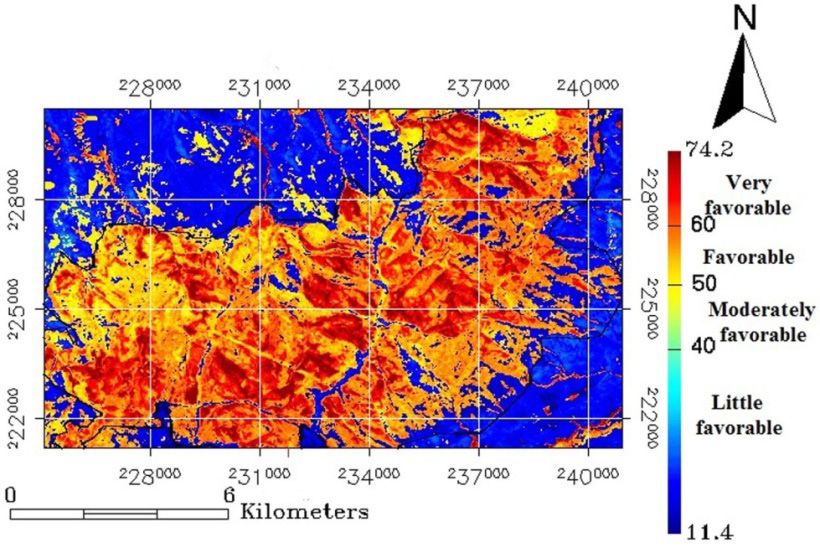
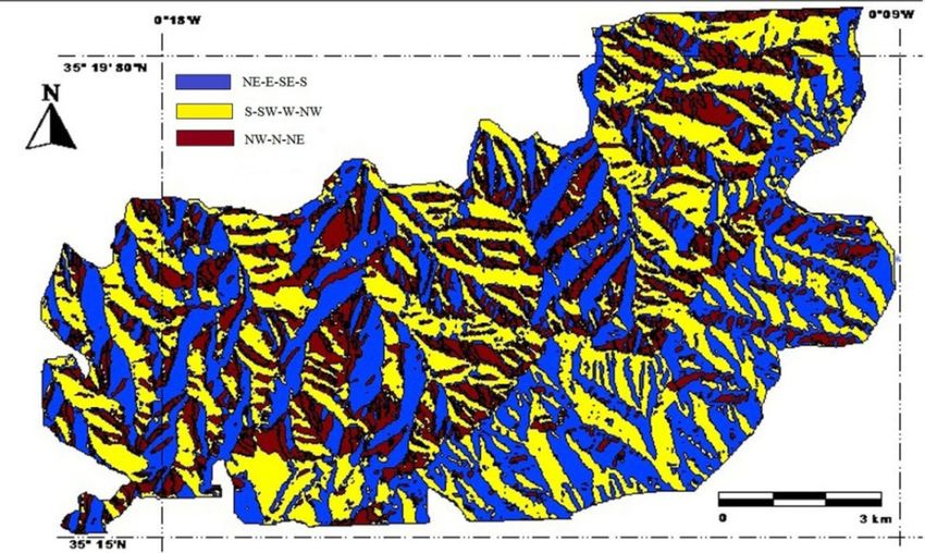
Map of exposure                      T a b l e 1. Frequency of exposures.
                                      Meaning                           Area (ha)        Percentage (%)
The forest massif of Guetarnia        NE—E—SE—S                          4,053.37             39.97
presents three major classes of       S—SW—W—NW                          3,992.66             39.37
exposure in relation with the         NW—N—NE                            2,094.59             20.65
prevailing winds, as listed in        Total                             10,140.12              100
Table 1.
    The exposure “‘e”’ reflects
the situation of the catchment
area in relation to the prevail-
ing winds and to the solar
radiation. The map of the ex-
posure of the forest is repre-
sented by the Fig. 4 below.

Map of topomorphology

The position in the catchment
area or topomorphology “‘m”’
weighted the fire intensity as       Fig. 4. Map of exposure.
a function of the position in
the terrain. Topomorphol-
                                     T a b l e 2. Frequency of the topomorphology.
ogy was adopted in preference
to altimetry. To do this, four        Meaning                                Area (ha)    Percentage (%)
main sets of topomorphologic          P< 3% (Plain)                             83.93           0.83
were retained in (Table 2; Fig.       P(3—12.5%) (Lower piedmont)             2,112.78         20.84
5). The four classes define the       P (12.5—25%)(High piedmont)             6,510.36         64.20
topographic situations in-            P> 25% (Mountain)                       1,433.05         14.13
                                      Total                                  10,140.12          100
creasingly unfavourable for
the fight (Belgherbi, 2002).
    The forest of Guetarnia
is represented by the sen-
ior foothills on an area of
6,510.36 ha (62.20%); the
fraction mountain represents
only an area of 1,433.05 ha
(14.13%).

Map of slopes

The slope “‘p”’ is a factor of the
acceleration of fire front. It is
classified into four classes.        Fig. 5. Map of topomorphologic.

                                                                                                     293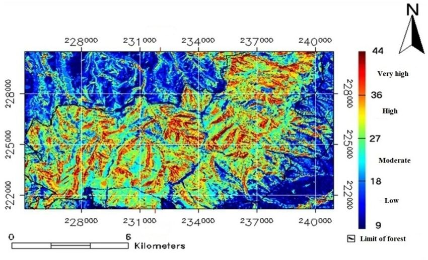
The threshold selected, for
                                                            each class, takes into account
                                                            the possibilities of executions
                                                            of forest work (Dagorne,
                                                            Duche, 1994). The map of
                                                            slopes obtained is represent-
                                                            ed by Fig. 6. The classes of
                                                            average and steep slopes are
                                                            most dominant with more
                                                            than 62%. The different per-
                                                            centages of the four classes
                                                            are summarized in Table 3.
Fig. 6. Map of slopes.
                                                            Map of      vegetation   index
T a b l e 3. Frequency of slopes.                           (NDVI)

 Class of slope                     Area (ha)   Rate (%)    As per the requirements of
 < 15%                               3,844.12    37.91      the study, a vegetation index
 15 %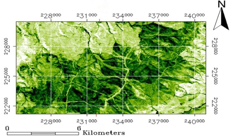
rate of 22.34%, and finally, to      T a b l e 4. The distribution of species.
bare soil and agricultural en-         Meaning                               Area (ha)   Rate (%)
claves in the order of 10.02%.         Pinus halepensis                      4, 148.83    40.91
This map highlights the clear          Tetraclinis articulata                2, 710.24    26.73
dominance of coniferous for-           Quercus rotundifolia                  2, 265.36    22.34
mations, which were close to           Bare Soil                              1,015.69    10.02
67.64% of the area of the for-         Total                                 10,140.12     100
est and increase the risk of
triggering the fires, we have
presented in the form of Table
4 and Fig. 8.

Exploitation of results

The risk assessment is neces-
sary to model each of the ele-
ments of risk. The first step is
to select the parameters spe-
cific to each element (slope,
exposure, topomorphology
and settlements) and then to
                                  Fig. 8. Map of the occupation of the ground.
use the mode of representa-
tion of the risk in order to
evaluate.           The param-
eters are the factors of the
natural environment and an-
thropogenic that influences
the outbreak, the spread and
the intensity of fire, as well as
its conduct (aspects related
to the fight). The second step
based on the intersection of
thematic layers by application
of the formulas cited previ-
ously. The human factor is
characterized by the occupa-
tion of space, since the forest Fig. 9. Map of the index of combustibility.
is not inhabited and is located
for enough away from the houses; the human index is equal to zero.

Evaluation of the index of combustibility

The map of index of combustibility, as shown in Fig. 9, has been achieved from the cross-
ing junction of vegetation index layer and occupation layer of the soil. The biovolume was
                                                                                                    295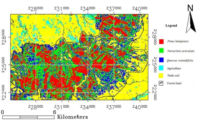
T a b l e 5. Notes of caloric species (CEMAGREF, 1989).
 Tree Species                   Note calorific value        Shrubby Species       Note calorific value
                                                          Or herbaceous species
 Pinus halepensis                         8                    Rosmarinus                  5
 Tetraclinis articulata                   7                     Phyllerea                  5
 Quercus rotundifolia                     7
 Bare Soil                                --                         --                    --

T a b l e 6. Indices of combustibility.                           calculated from the layer of
 Class                              Area (ha)             Rate (%)vegetation index, but against
 IC < 40                             1,819.33              17.94  the notes of calorie intensity
 40 < IC < 50                        1,234.88              12.18  (E1 and E2) that have been
 50 < IC < 60                        6,632.63              65.41  extracted from the layer of
 IC > 60                              453.28                4.47  occupation of the ground
 Total                              10,140.12               100   (Table 5). The two notes ca-
                                                                  loric of species present in the
                                                                  Guetarnia forest are those
established by (Dagorne, and Castec, (1992) ; and Colin et al., (2001) with the exception
of Tetraclinis articulate, which has been equated with the closest species Juniperus (CEMA-
GREF, 1989).
    The values of index of combustibility, took into consideration, four classes ranging from
a low rating, medium, high and very high (Table 6).
    More than 70% of the surface area of the forest of Guetarnia is located in ‘hight’ and ‘very
hight’ classes of index of combustibility; the rest is between ‘low’ and ‘medium’ severity with
values respectively 17.94 and 12.18%. This index typically represents bare soils and areas of
low vegetation density (Fig. 9).

Evaluation of the topomorphologic index

The topomorphologic index is obtained by a combination of three criteria (slope, exposure
and topomorphology), using the following formula:

    IM = 3p + e.m			                            (5)

where: p is slope (coded between 1 and 4), ÷e÷ is exposure (coded 0 to 3), and m÷ represents
the morphology of the area (coded of 1 to 4).
     This index is a factor in the calculation of risk index, depending on the topographic situ-
ation and of the exhibition encountered, aggravating more or less the spread and power of
the fire. The results obtained allow us to get four classes of topomorphologic, summarized
according to their importance in the Table 7.
     Nearly 52% of the surface area of the forest of Guetarnia is located in the conditions to-
pomorphologic little favourable to fire accentuation. The conditions moderately favourable to
fire risk cover the surface area of 44.63%, and only 4% is in the range very favourable (Fig. 10).

296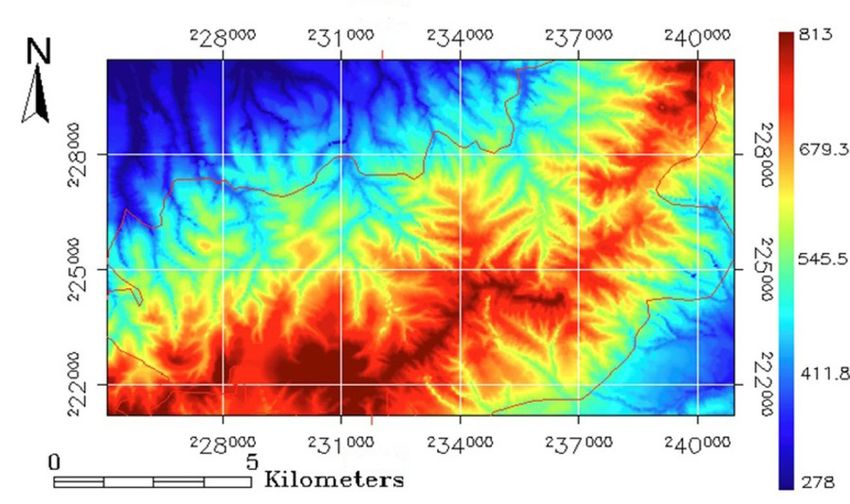
The topomorphologic in-       T a b l e 7. The classes of the index topomorphologic.
dex moderately favourable          Classes                                       Area (ha)    Percentage (%)
to very favourable represents      M < 9 (little favourable)                      5,253.53         51.81
fractions of high slopes and       9 < IM < 14 (moderately favourable)            2,586.40         25.50
steep. The slope influences        14 < IM < 19 (favourable)                      1,939.46         19.13
the spread of fire; it acceler-    IM > 19 (very favourable)                       360.73           3.56
ates its speed in the catch-       Total                                         10,140.12          100
ment area and then, it slows
down (Traubaud, 1979; Mis-
soumi, Tadjraoui, 2003).

Evaluation of fire risk index

The evaluation of fire risk
index is the result of inter-
section between the layer of
combustibility index and the
layer of topomorphologic in-
dex. The index is given by the
following formula:
                                  Fig.10. Map of the indextopomorphologic.
   IR = 5.IC + IM           (6)
                                  T a b l e 8. Indices of fire risk.
where: IR is the Risk index, IC
                                   Class                                    Area (ha)        Percentage (%)
is the index of combustibility
                                   IM < 18(low risk)                         1,873.52             18.48
and IM is the topomorpho-
                                   18 < IM < 27(medium risk)                 5,748.61             56.69
logical index.
                                   27 < IM < 36(high risk)                   2,440.56             24.07
    The forest of Guetarnia is
                                   IM > 36(risk very hard)                     77,44               0.76
located in medium to strong        Total                                    10.140,12              100
risk index, covering an area
of 8, 189.17 ha or 80.76%. The
low risk remains fairly high
with a rate of 18.48%; and
the resth is barely 1%, is very
great danger as the confirmed
by the rates as shown in the
Table 8 and Fig. 11.

Discussion

The forest of Guetarnia, share
its floristic composition di-
versified, a vegetation density   Fig. 11. Map of the index of fire risk.

                                                                                                        297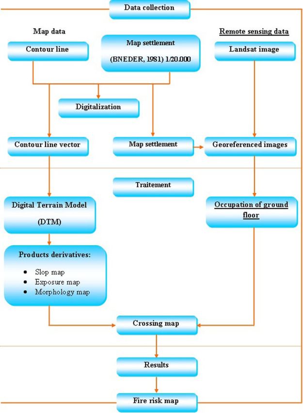
strong enough and a presence of woody species including the combustibility and flammabil-
ity are very high is classified in terms of vulnerability to fire risk between medium and high.
    The composition and structure of forest stands, in this case the vertical and horizontal
distribution of species, determine their flammability and combustibility, and conditioning
the process of putting to fire and the power with which the fire is going to maintain and
spread (Colin et al., 2001).
    Some plant species are more vulnerable to fire than others. The significant presence of the
Pinus halepensis Mill; the species qualified as being the most flammable and combustible of
Mediterranean forests (Velez, 1994; Ramade, 1997; Dimitrakopoulos, Mitsopoulos, 2006); in
space and in density determines the high risk of fire of the drill bit.
    The matorral is more willing to be damaged by the lights as the forest formations are
wooded. This situation is explained quite easily by the difference in the composition of these
formations and by the climatic conditions to which they are subjected to. The predisposition
of the plant formations to fire is, in effect, related to a large extent to their water content. The
latter is strongly influenced by the general conditions of drought (temperature and dryness
of the air, lack of precipitation, and episodes of winds dry and violent). These conditions of
predisposition are not constant in time. They evolve, for example, according to the state of
vegetation, which is the result of both its natural dynamics; forestry is applied to it and of the
potential passages of the fire (Assali et al., 2016).
    In addition, conditions such as topomorphologic, slope and exposure, which determine
the factors that are conducive to triggers and enhance the forest fires. From the point of view
of biophysics, the expression of fire in a natural space is a function of its environment, includ-
ing, of course, climate, the nature of the terrain and the fuel present in the area concerned
(Pyne et al., 1996). Therefore, the spatial models that simulate the behaviour of fire, often
use as input data the variables measured as altitude, slope, exposure, weather and vegetation
(Anderson, 1982; Andrews et al., 2005). These factors are at the origin of the outbreak of the
fire and its rapid spread. For example, the angle of slope affects the moisture and conserva-
tion of the soil, which in turn affects the distribution of vegetation and its composition, and
as a result, the characteristics of the fuel and its flammability (Franklin, 1998).
    In effect, the biophysical factors that influence the outbreak of fire and its spread can
produce multiple consequences, direct and indirect, on the regime of fire (Whelan, 1995)
    This index of risk of lights high enough for the forest of Guetarnia is also the result of al-
most total lack of silvicultural work and planning. The forest is currently composed of young
stands following the escalation of lights on one hand and to high frequency and very close
to the lights.

Conclusion

Despite the importance of the phenomenon of forest fires in Algeria, the causes of these
fires are still unknown, which complicates any prevention plan. The analysis of information
relating to forest fires has revealed that more than 90% of the causes are listed as unknown.
The strategy for the management of risk of forest fires in Algeria is support on the interven-
tion where as the techniques having done their evidence are based mostly on forecasts and

298
prevention. However, the forest fires cannot be minimized through prevention, which rests
on risk assessment. The map of vulnerability of the forest fires extracted from the forest of
Guetarnia shows a model of application of remote sensing and GIS that can be generalized
on the forest ecosystems closely, enough. Moreover, the risk map carried out allows demon-
stratingthe severity of risk incurred following the outbreak of fires from the physical factors
(topomorphology, slope and exposure) and biological (vegetation).Thus, it allows to orient
the managers in the field of forest fire fighting and to locate the means of intervention for
rapid action in time and space.
References
Anderson, H.E. (1982). Aids to Determining Fuel Models for Estimating Fire Behavior. USDA Forest Service, Inter-
mountain Research Station, General Technical Report INT-167.
Andrews, P.L., Bevins, C.D. & Seli R.C. (2005). Behave Plus Fire Modeling System, version 3.0: user’s guide. USDA
Forest Service, Rocky Mountain Research Station, General Technical Report RMRS-GTR-106WWW Revised.
Arafa, A. (2008). Les incendies de forêt en Algérie : Stratégies de prévention et plans De gestion. Thèse doctorat, uni-
versité de Constantine, Algérie.
Assali, F., Rouchdi, M., Ajerame, M.,Lahlou, M. & Mharzi H. (2016).Cartographie du risqued’incendies de forêtdans
la région de Chefchaouen-Ouazzane (Maroc). Revue. Mar. Sci. Agron. Vét., 4(2), 5−22.
Belgherbi, B. (2002). Intégration des données de télédétection et des données multisources dans un système d’information
géographique (SIG) pour la protection des forêts contre les incendies (cas de la forêt de Guetarnia-Ouest d’Algérie).
Thèse, Université de Tlemcen, Algérie.
Benabdeli, K. (1996). Aspects physionomico-structuraux de la végétation ligneuses forestières face aux pressions an-
thropozoogènes dans les monts de Dhaya et les monts de Tlemcen. Thèse doctorat, Université d’Aix-Marseille III,
France.
Berchiche, T. (1968).Contribution à l’étude socio-économique de la forêt algérienne. Thèse d’agronomie, INA Alger,
Algérie.
Berrichi, M., Benabdeli, K. & Leutreuch B.N. (2013). Feux de forêts en Algérie : entre points de vue des écoliers et
politique de la prévention. Mediterranea, ÉpocaII, 24,132−159. DOI: 10.14198/MDTRRA2013.24.05.
Borsali A.H., Benabdeli, K. & Gros R. (2014). Dynamique structurelle de la végétation en zone semi-aride : cas de la
forêt de Fénouane (monts de Saida, Algérie occidentale). Afrique Science, 10(2), 419−433. www.afriquescience.
info.
Boudy, P. (1948). Economie forestière Nord-Africaine. Paris:Larose.
Carrega, P. (2008). Le risque d’incendies de forêt en région méditerranéenne: compréhension et évolution. Actes des
colloques de l’AIC, 9−13 septembre 2008 (pp. 11−23). Montpellier.
CEMAGREF (1989). Guide technique du forestier méditerranéen français, protection des forêts contre les incen-
dies. Edition Quae, France.
Colin, P.Y., Jappiot, M., Mariel, A., Cabaret, C.,Veillon, S. & Brocchiero F. (2001). Protection des forêts contre l’incendie:
fiches techniques pour les pays du bassin méditerranéen. FAO conservation, IRNAE, CEMAGREF, MAPA.
Dagorne, A. & Castec J.M. (1992).Gestion des espaces forestiers en zones rouges. Finisterra, 27(54), 141−166. DOI:
10.18055/Finis1884.
Dagorne, A. & Duche A. (1994). Protection des forêts contre les incendies et Système d’information géographique:
Application à la commune d’Auribeau sur Siagne (Alpes Maritimes). Forêt Méditerranéenne, 25(4), 416−419.
Dalloni, M. (1940). Note sur la classification du Pliocène supérieur et du Quaternaire de l’Algérie. Bulletin de la
Société de Géographie et d’Archéologie, 8−43.
Dalloni, M. (1953). La limite du Tertiaire et du Quaternaire dans le nord-ouest de l’Algérie et des contrées voisines.
ActeIV eCongrès International Quatrenaire, 1,19−28.
De Ribbe, Ch. (1866). La question des incendies de forêts dans l’Algérie et dans les aures de la Provence. Revue Agro-
Forestière, 201−213.
DGF (2014). Situation des forêts algériennes vis-à-vis les incendies et les feux de forêts.
Dimitrakopoulos, A.P. & Mitsopoulos K. (2006). Global forest resources assessment 2005. Report on fires in the Medi-
terranean Region. Working paper FM/8/E, Forestry Department. Rome: FAO.
299FAO (2013). Etat des forêts méditerranéennes. Italie: FAO.
FOSA (2000). L’étude prospective du secteur forestier en Afrique. Italie: FAO.
Franklin, J. (1998). Predicting the distribution of shrub species in Southern California from climate and terrain-
derived variables. Journal of Vegetation Science, 9, 733−748. DOI: 10.2307/3237291.
Hansen, M.C., Potapov, P.V., Moore, R., Hancher, M., Turubanova, S.A., Tyukavina, A., Thau, D., Stehman, S.V.,
Goetz, S.J., Loveland, T.R., Kommareddy, A., Egorov, A., Chini, L., Justice, C.O. & Townshend J.R. (2013).
High-resolution global maps of 21st-century forest cover change. Science, 342, 850−853. DOI: 10.1126/sci-
ence.1244693.
Keane, R.E., Drury, S.A., Karau, E.C., Hessburg, P.F. & Reynolds K.M. (2010). A method for mapping fire hazard
and risk across multiple scales and its application in fire management. Ecological Modelling, 221(1), 2−18. DOI:
10.1016/j.ecolmodel.2008.10.022.
Khader, M., Benabdeli, K., Mederbal K., Fekir, K., Gueddim, R. & Mekkous B. (2009). Etude du risque incendie
à l’aide de la géomatique cas de la forêt de Nesmoth (Algérie). Mediterránea, 20, 205−234. DOI: 10.14198/
MDTRRA2009.20.07.
Leutreuch, B.N. (1982). Le reboisement en Algérie et ses perspectives d’avenir. Thèse doctorat, Université de Gem-
bloux, Belgique.
Madoui, A. (2002). Les incendies de forêt en Algérie: Historique, bilan et analyse. Forêt Méditerranéenne, 23, 23−30.
Mariel, A. (1998). Evaluation et cartographie du risque d’incendie de forêt vers une Application sur le massif des
Maures (sud-est de la France), à l’échelle des PPR. Ingénierie, 105−114.
Meddour, O.S., Meddour, R., Vittorio, L. & Derridj A. (2014).Motifs des incendies de forêt en Algérie : analyse com-
parée des dires d’experts de la Protection Civile et des Forestiers par la méthode Delphi. Vertigo, 14 (3). DOI:
10.4000/vertigo.15462.
Meddour, O.S. (2015). Wildfires in Algeria: problems and challenges. iForest-Biogeosciences and Forestry, 8, 818−826.
DOI: 10.3832/ifor1279-007.
Missoumi, A. & Tadjerouni K. (2003). Apport SIG et imagerie Alsat1 pour la cartographie des risques d’incendie de
forêt. 2nd FIG Regional Conference, 2-5 December 2003, Marrakech, Morocco.
Mohamed, S.G., Amar, D., Makhlouf, B., Bounif, A., Mostefa, G. & Amar B. (2011). A fire risk modelling and
spatialization by GIS - application on the forest of Bouzareah Clump, Algiers (Algeria). Journal of Geographic
Information System, 3, 254−265. DOI: 10.4236/jgis.2011.33022.
Nedjraoui, D. (2003). Profil fourrager. Italie: FAO.
Putri, A., Lilik, B.P. & Siti B.R. (2016). Forest fire vulnerability mapping in Way Kambas National Park. Procedia
Environmental Sciences, 33, 239−252. DOI: 10.1016/j.proenv.2016.03.075.
Pyne, S.J., Andrews, P.L. & Laven R.D. (1996). Introduction to wildland fire. NewYork: Wiley.
Ramade, F. (1997).Conservation des écosystèmes méditerranéens: enjeux et prospective. Paris.
Rebai, A. (1983). Les incendies de forêts dans la wilaya de Mostaganem (Algérie): étude écologique et proposition
d’aménagement. Thèse doctorat, Université de Science Marseille, France.
Rowell, A. & Moore P.F. (2000). Global review of forest fires. Gland:WWF/IUCN.
Sari, D. (1978). Le déboisement de l’Algérie. Doc CNRS, 17, 102−164.
Souidi, Z., Hamimed, A., Donze, F., Seddini, A. & Mederal K. (2010). Estimation de l’évapotranspiration d’un cou-
vert forestier en Algérie par télédétection. Télédétection, 9 (3−4), 164−181.
Terras, M., Benabdeli, K. & Labani A. (2008). Dynamique phytoécologique du Thuya de Berberie face à l’incendie.
Forêt Méditerranéenne, 29, 33−40.
Traubaud, L. (1979). Les feux des forêts: mécanismes, comportement et environment. Ed Aubervilliers, France.
Trollard, P. (1893). La colonisation et la question forestière. Paris: Larose.
Velez, R. (1994). La protection contre les incendies de forêts: principes et méthodes d’action. Options Méditerranée-
nnes, 26, 1−18.
Whelan, R.J. (1995). The ecology of fire. Cambridge: Cambridge University Press.
300You can also read