Maps & enhanced content - Delivering high quality maps to enterprise, government, automotive and consumer markets
←
→
Page content transcription
If your browser does not render page correctly, please read the page content below

Maps & enhanced
                           content
                           Delivering high quality maps
                           to enterprise, government,
                           automotive and consumer markets

maps & content | real time & historical traffic | lbs

                       www.tomtom.com/licensing
Superior location based services
    How seamless coverage is community driven

    The freshest map                                       The most accurate real time traffic information

    The heart of location services is the map and          Want to beat the traffic? Choose a better route.
    TomTom delivers the most current digital map of        TomTom real time traffic products harness multiple
    the world.                                             data sources to keep drivers in control of their
                                                           journeys. Road sensors and real traffic incident data
    Since 2006 TomTom has collected anonymous              are fused with the anonymous GPS measurements
    GPS measurements from its users. This unique           of TomTom device users to create a vivid picture of
    community input is combined with knowledge             traffic conditions as they evolve.
    harvested from local experts and it is combined
    with traditional sources including paper maps, field   This empowering data is made available to
    surveys, aerial and satellite imagery and mobile       industry partners in the Consumer, Enterprise, and
    mapping vans. The result is a dynamic map full of      Government markets.
    enhanced content ranging from points of interest to
    3D city maps. TomTom coverage extends over 200
    countries and territories, encompassing more than
    5 billion people and 35 million kilometres globally.

        TomTom uses multiple sources to build the               Real time traffic enables navigation with
                    freshest map                                     up-to-the-minute information

2     Superior location based services
The largest resource to predict traffic flow

Whereas traditional technologies struggle to track the ever expanding
traffic on our road networks, TomTom uses this to its advantage.
More traffic means more TomTom customers and over 5 trillion
consumer-driven data points have been collected from anonymous
GPS measurements worldwide. This ever expanding historical
traffic database allows industry partners to analyse travel times and
bottlenecks accross the complete road network.

                                       United States

                                                       Europe

               5+ trillion consumer-driven data points collected to
                              date and growing daily

maps & content | real time & historical traffic | lbs

                             www.tomtom.com/licensing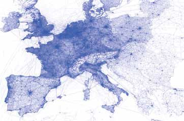
Map
           With precision comes differentiation. By making the freshest and most
           accurate maps, TomTom gives partners the tools to separate themselves
           from their competition.

           Business intelligence, personal navigation, itinerary planning, geocoding,
           geo-spatial analysis, fleet management, customer support, business
           expansion and automotive applications are just some of the areas being
           exploited by enterprise and government partners. With TomTom, complex
           geographic relationships are easily understood and analysed so organisations
           can respond rapidly to changing market conditions and achieve significant
           cost savings.

           Real world examples are numerous: Insurance partners benefit from
           accurately locating policyholders in relation to risk data sets like wind, hail
           and flood zones. Road planners can identify and fix congestion bottlenecks.

           National and international chain stores correlate TomTom map data to
           pinpoint the exact placement of their next branches.

           Consumer, enterprise and government partners worldwide rely on TomTom
           to build some of the most innovative solutions in their industries. With
           TomTom such rich, fresh and accurate data is at your fingertips so the only
           limit is your imagination.

           How we make maps

                                                                    Additional Content
                                                                                               Find

                                                                                                                         Display
                                Satellite imagery
                                                                          Address Points               2D City Maps

                                Community input                                                        3D Landmarks &
                                                                          Administrative Areas
                                                                                                       Landmark Icons

                                Mobile mapping van                                                     Advanced City Models
                                                                          Points of Interest

                                Aerial images                             Post                         Digital Elevation Model
                                                                                               Guide

                                Field Surveys                             Advanced Driving             Junction View Services
                                                                          Attributes

                                Digital & paper maps                      Logistics                    SignPost images

                                Partners                                  Voice Maps                   World Boundary Map

4   Maps
Map quality definitely matters
We are a map making company with over 20
years’ expertise. Continuous investment and over
2,000 persons help us provide the freshest and
most accurate maps with best-in-class safety and
                                                                                  “Our maps are there
attributed navigation.
                                                                                  for those who care
Our unique ‘hybrid’ map-making delivers content
of certified quality. We use an innovative approach
                                                                                  about quality and
which combines traditional sources such as satellite
imagery, field surveys, mobile mapping vans and
                                                                                  reliability.”
fleets with rigorously controlled community input.

We are committed to develop our maps even further
with the objective of reaching 100% coverage while
continuing our best-in-class safety and navigation
map attribution.

                                                                                                                     ConnectPlus
                                                 ConnectPlus

                                                                                                          MultiNet
                                      MultiNet

                                                                                                                                       Connect
                                                               Connect

Functionality                                                            Markets
Turn-by-turn navigation                                                  Financial Services                                        (         )
Basic navigation                                                         GeoAnalytics
Routing and display                                                      Government
Geocoding                                                                Insurance
                                                                         Internet
                                                                         Portable & Wireless
                                                                         Retail
                                                                         Transportation & Logistics
                                                                         Utilities & Telecommunications

maps & content | real time & historical traffic | lbs

                             www.tomtom.com/licensing
The world’s most extensive digital map database

           MultiNet
           Over 20 years TomTom has been creating          MultiNet is more than just maps. It also
           the world’s most extensive digital mapping      incorporates added functionality such
           database. The pinnacle of this hard work        as turn-by-turn directions, road signage,
           is MultiNet, a road network database with       intersections, positioning centrelines for
           detailed and rigorously tested data designed    drivable roads and streets and major POIs.
           for application providers in highly developed   All information is consistently formatted with
           countries.                                      global specifications, enabling application
                                                           developers to combine and expand their
           MultiNet is suitable for the most demanding     geographical coverage seamlessly.
           high-end applications including turn-by-
           turn navigation and traffic telematics. It
           is the foundation for TomTom customers
           in every market supporting all segments,
           from Enterprise to automotive. More than
           50,000 global sources provide MultiNet
           with a constant stream of updates which are
           delivered on a quarterly basis. This means
           partners can be sure of the richest, freshest
           and most accurate mapping data.

6   Maps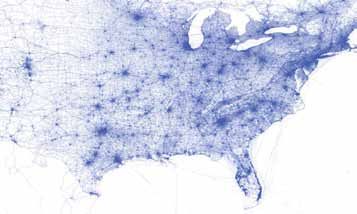
ConnectPlus
While MultiNet covers a significant portion of the globe, certain
geographies have yet to be incorporated into this top-tier database.
Many application providers have an urgent need for data in every
corner of the world and they are turning to ConnectPlus.

ConnectPlus was created in response to growing demand for navigable
coverage in key geographic regions such as Africa, South America,
and Asia Pacific. ConnectPlus supports basic mapping, routing and
navigation functions, and allows cross-border routing to link the
ConnectPlus road network seamlessly to the MultiNet database.

One day the entire planet will be covered with the richness and level
of detail present with MultiNet. Until that time, TomTom understands
the need for an effective solution for a single, global digital map.

With ConnectPlus the result is greater coverage for partners in more           Cross-border routing
regions in the fastest possible timeframe.

                                    Connect
                                    When personal navigation is not required, Connect is the answer.
                                    Connect marries basic routing and displays functionality with geocoding
                                    which makes it ideal for Internet, wireless and enterprise applications
                                    in areas where MultiNet and ConnectPlus are not available. When
                                    combined with MultiNet and ConnectPlus, TomTom covers the globe.
                                    As TomTom’s digital map data continuously matures, many countries
                                    will transition towards the ConnectPlus or MultiNet format.

                                    This smooth advance isn’t only demonstrated by TomTom’s evolving
                                    database: Connect itself is linked to TomTom’s navigable coverage
                                    for seamless, cross-border routing. With MultiNet, ConnectPlus and
                                    Connect, TomTom provides distinct types of digital maps to balance
                                    the demand for expanded geographic coverage with stringent quality
                                    standards. The result is a single, global digital map solution.

  Connect enables geocoding,
      routing and display

maps & content | real time & historical traffic | lbs

                            www.tomtom.com/licensing
Enhanced content
                   The map is the heart of TomTom’s location-based
                   services. In creating the world’s most current digital
                   map, TomTom has laid the perfect foundation
                   for adding enhanced content that will enrich the
                   properties of the maps as well as the customer
                   experience.

                   MultiNet is enriched by a portfolio of enhancement        Find
                   products that can be broken down into 3 categories:
                   Find, Guide and Display.

                   Find is about helping users find locations of people,
                   places and products important to their daily lives.

                   Guide is about generating accurate, safe, efficient
                   and customisable routes in real time, with clear
                   visual and audio instructions.                           Guide

                   Display makes the visual side of navigation more
                   realistic, more detailed and more useful for end
                   users.

                   By coupling MultiNet with enhancement
                   products that enable Guide, Find and Display
                   capabilities,TomTom can add real value and increase
                   the potential for applications.                          Display

8   Enhanced content
Find
              Address Points delivers the ultimate in geocoding
              accuracy by pinpointing discrete, actual street
              addresses to physical buildings or property parcels.
              TomTom further incorporates address data from
              many private and government sources hence avoid
              the application of interpolated address ranges used
              by most rival geocoding products.

              Administrative Areas offers commercial grade
              boundaries of municipal and census defined
              geographic divisions in the United States and
              Canada. Changes are tracked along with shifting
              legal boundaries to help steer analysis and key
              strategic initiatives.

              Points of Interest provides over 38 million POIs
              globally allowing users to find the people, places
              and services they need. Basic POIs are contained
              in the core MultiNet database, with a premium
              dataset available separately and validated quarterly
              to ensure accuracy and currency.

              Post drives enterprise efficiencies with cartographic
              representations for valid postal codes in the United
              States and Canada. It extends the functionality of
              MultiNet by providing detailed point and boundary
              representations of postal districts, linking to
              municipal and census layers for additional analytical
              capabilities.

maps & content | real time & historical traffic | lbs

                         www.tomtom.com/licensing
Guide

                      Advanced Driving Attributes are TomTom’s
                      portfolio of content, such as slope and curvature,
                      which is compliant with Advanced Driver
                      Assistance Systems (ADAS). They offer an array of
                      attributes typically unavailable to manufacturers’
                      spanning major and minor roads to enhance safe
                      and efficient driving.

                      Logistics is a comprehensive, global digital map
                      database specifically designed for fleet owners and
                      operators who manage large trucks and other road
                      restricted vehicles. It helps save time and money
                      by enabling large truck or fleet-specific routing
                      solutions.

                      Voice Maps allows speech technology to be
                      integrated into map applications, taking the quality
                      of spoken instructions and voice recognition
                      to a much higher level. They help developers
                      differentiate their solutions and make driving safe
                      and more efficient enabling a much better user
                      experience.

10 Enhanced content
Display
2D City Maps responds to the growing demand for more realistic map
displays allowing end users to quickly recognise their surroundings. It
is available in two detail levels with outlines of buildings, visible land
use and railways infrastructures shown for the most essential cities
around the globe.
3D Landmarks & Landmark Icons provide realistic and easy to
recognize reference points with three dimensional representations
of famous buildings and monuments. Available in three sizes to suit
devices of different performance and memory, these visual waypoints
enhance navigation and appeal to travellers.
Advanced City Models are easily integrated three dimensional
representations of major city centres which bring clarity and reality to
the map. Four detail levels are available from simple shoebox models
to photo-realistic textured models providing a superior end user
experience in more cities than ever before.
Digital Elevation Model makes it possible to display the contour
of the earth’s hills and valleys on devices and in applications across
Europe, North America and Asia Pacific. Through use of Digital
Elevation Model, roads, satellite imagery and other two-dimensional
information can be draped over accurate altitude data to enrich the
user experience in navigation and other applications, adding the
benefit of 3D display.
Junction View Services provide drivers with more accurate, detailed
display and visual guidance instructions when approaching a decision
point or manoeuvre situation. Its implementation can lead to safer
and more confident driving.
Signpost Images are a graphic representation of the signpost
information which is stored in MultiNet, TomTom’s global navigable
map.
World Boundary Map delivers realistic and accurate visualisation
of border patterns globally with physical, political and geographical
features. It is fully integrated with MultiNet to enable display
enhancements.
maps & content | real time & historical traffic | lbs
www.tomtom.com/licensingContact info
© 2012 TomTom. All rights reserved.
Americas
Concord Lebanon
150 Baker Ave Ext 11 Lafayette St
Concord, MA 01742 Lebanon, NH 03766
United States United States
Phone: +1 978 287 9555 Phone: +1 603 643 0330
Asia Pacific
Taiwan China
32F, No. 66, Section 1, Zhongxiao West Road B1811-1815, City Center
Taipei City, Taiwan 10018, R. O. C. No.100 Zunyi Road
Phone: + 8862 2331 5889 200051 Shanghai
Phone: +86 186 2161 6018
EMEA
Belux Italy & Eastern Europe The Netherlands & Nordics
Gaston Crommenlaan 4 bus 0501 ia Messina, 38 Torre C
V De Ruyterkade 154
B-9050 Gent 20154 Milano 1011 AC Amsterdam
Belgium Italy The Netherlands
Phone: +32 9 244 88 11 Phone: +39 0234 874126 Phone: +31 20 757 49 29
DACH South Africa UK & Ireland
Am Neuen Horizont 1 Ground Floor, Block B, 286 Euston Road
D-31177 Harsum Southdowns Office Park, NW1 3AS, London
Germany Karee Street United Kingdom
Phone: +49 (0) 5127 408 0 Off John Vorster Drive, Phone: +44 (0)207 3875444
Centurion
South Africa
Phone: + 27 12 345 6700
France Spain & Portugal
09/111 Avenue Aristide Briand
1 venida de la Vega nº 1
A
92120 Montrouge Edificio 1//planta 2
France 28108 Alcobendas-Madrid
Phone: +33 1 47 46 72 00 Spain
Phone +34 91 378 99 10
About TomTom
Founded in 1991, TomTom (AEX:TOM2) is TomTom Licensing is the division of TomTom
the world’s leading supplier of location and dedicated to delivering relevant, fresh and
navigation products and services focused high-quality digital maps, and dynamic
on providing all customers with the world’s content, to a wide range of business
best navigation experience. Headquartered in customers. Our product portfolio includes the
Amsterdam, TomTom has 3,500 employees and world’s freshest digital maps covering over
sells its products in over 40 countries. 200 countries and territories globally, as well
as the most accurate real time and historical
traffic products.
2012.12.MC.EN
maps & content | real time & historical traffic | lbs
www.tomtom.com/licensingYou can also read