March 13, 2020 Severe Weather Across West Texas
←
→
Page content transcription
If your browser does not render page correctly, please read the page content below
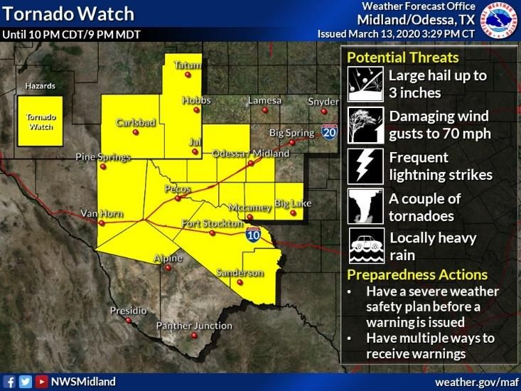
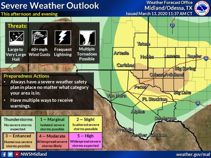
March 13, 2020 Severe Weather Across West Texas
Overview/Synopsis
In the days leading up to the severe weather event of Friday, March 13, an upper trough had
been anchored over the western US, resulting in a persistent fetch of moist southwesterly flow
aloft across Southeast New Mexico and West Texas. At the surface, a cold front that moved
into the region during the early morning hours of March 13th, stalled near the Pecos River, and
would later act as a focusing mechanism for the afternoon and evening’s severe weather. North
of this boundary, unseasonably cool temperatures and widespread fog (dense in some areas)
were observed across much of the Permian Basin and into portions of Southeast New Mexico.
These cooler temperatures and fog likely mitigated a much larger-scale severe weather
outbreak. To the south of this boundary, southerly to southeasterly surface flow yielded
significant low-level moisture and the environment was becoming increasingly favorable for
significant severe weather, including tornadoes, during the afternoon and evening hours of the
13th.
Model guidance was consistent in indicating development of severe storms across portions of
Southeast New Mexico and West Texas (west of the Pecos River) by late afternoon.
Coordination between the Midland Weather Forecast Office and the Storm Prediction Center,
including a special early-afternoon weather balloon launch at Midland, yielded an upgrade to
an Enhanced Risk of Severe Weather during the afternoon and evening hours of March 13th for
an area spanning from the Upper Trans Pecos across portions of the central and southern
Permian Basin. A Tornado Watch was issued just after 3:15 PM CDT, around 1.5 hours prior to
the first storms developing across Eddy and Culberson counties.

Severe Thunderstorm #1
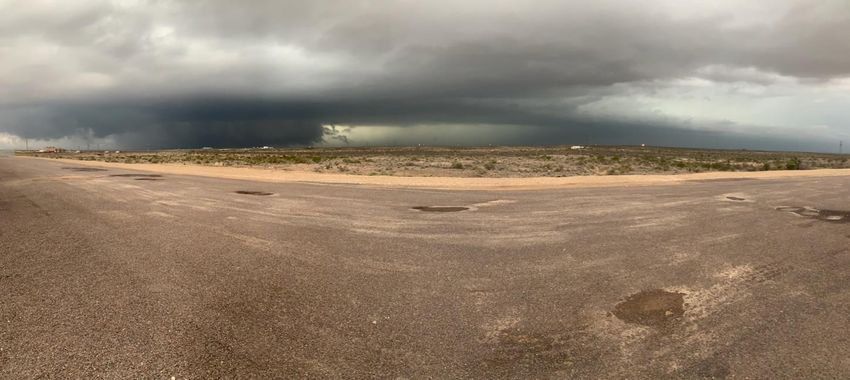
There were 2 main thunderstorms that stole the show Friday evening, producing strong winds
and tornadoes. The first of which was a supercell thunderstorm that developed over eastern
Culberson County and moved ENE, rapidly strengthening over northern Reeves County (see
image below). Severe hazards expected with this storm included large hail, damaging winds,
and a possible tornado. Around 7:50pm CDT, this storm passed east of HWY 285 roughly 15
miles west of Mentone, TX. A possible tornado was then reported with this storm along with
significant damage to the HWY 285 RV Park (located around 15 miles southeast of Orla). The
tornado was reported to have moved east into Loving County, lifting before reaching HWY 302
(moving just north of Mentone). The storm continued to weaken as it progressed eastward and
eventually fizzled out as it reached Winkler County.
Photo: Cruz Morales
Photo: Sean Ramsey
Photo: Reeves County Sheriff’s Office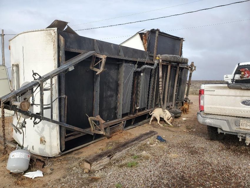
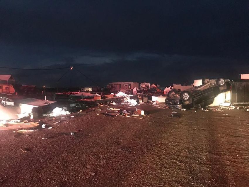
Severe Thunderstorm #1: Damage Survey Results
On Saturday, March 14, the National Weather Service in Midland conducted a damage survey
of the HWY 285 RV Park and surrounding areas that were impacted by severe weather on
Friday evening. The following is the determinations of that survey:

The main area of significant damage that occurred was at the HWY 285 RV Park, located in
northeast Reeves County about 15 miles southeast of Orla. While spotters and the public
provided visual evidence that a tornado did occur in the area, it was determined by the NWS
survey team that damage at the RV park was the result of rear-flank downdraft winds - a
straight-line wind event. Due to the significant damage at the RV park, the survey team
established wind speeds of 100-130 miles per hour. This was based on damage to trailers,
outbuildings, vehicles, and other structures. These types of wind speeds, especially the stronger
wind speeds, would be on
par with damage produced
by a strong EF2 tornado. In
the end, it was determined
that the swath of damaging
winds was around 300 yards
wide and 0.75 miles in
length. There was one major
injury related to this event.
Due to poor road networks, the damage survey team was unable to locate damage directly
caused by the tornado. Photos provided by the public and emergency management suggest
that the tornado was significant, however due to a lack of damage indicators, the team was
unable to determine a path and intensity. Thus, the tornado will be rated a EF unknown. By
utilizing storm spotter reports and radar signatures, it was estimated that this tornado traveled
roughly 12 miles before lifting.
We would like to thank Jerry Bullard, Reeves County Emergency Management Coordinator, and
Harlan Hopper, Ward County Emergency Management Coordinator, for their assistance in
completing this damage survey.

Severe Thunderstorm #2
This thunderstorm developed over western Reeves County, just north of Interstate 20 around
7:05pm CDT. This cell strengthened as it progressed northeast toward Pecos, TX and paralleled
Interstate 20 for nearly 2.5 hours. When the storm finally passed into Ward County,
approaching Barstow, TX, decent rotation was noted on radar and a few minutes later around
8:20pm CDT, a bowl-shaped tornado and power flashes was reported just north of Barstow.
Damage to northern portions of Barstow was eventually reported to the NWS. The tornado
appeared to be brief with only a few other reports of funnel clouds as this storm moved just
north of Pyote and eventually Monahans. The storm maintained decent supercell structure as it
entered Ector County around 9:20pm, after which it quickly weakened.

     Photo: Matt Coker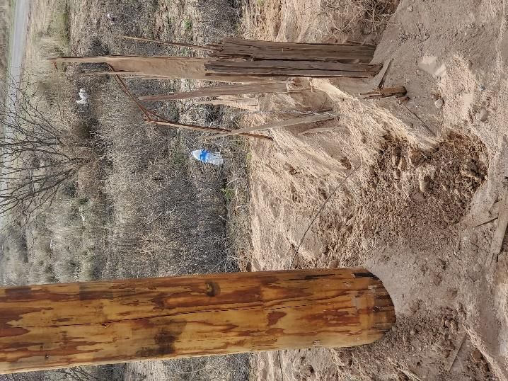
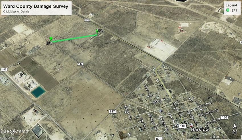
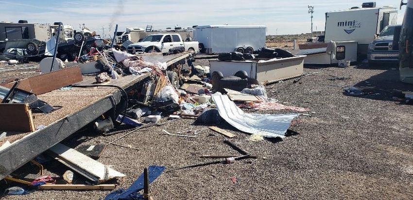
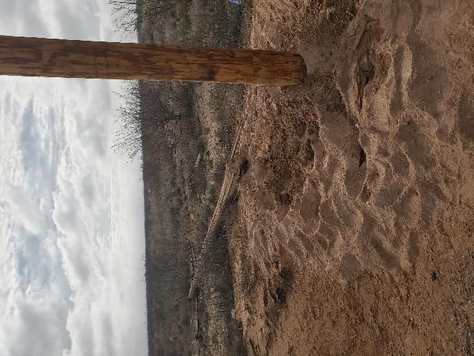
Severe Thunderstorm #2: Damage Survey Results
On Saturday, March 14, the National Weather Service in Midland conducted a damage survey
of areas that were impacted by severe weather on Friday evening. The following is the
determinations of that survey:

It was found that minimal damage due to a tornado
occurred approximately 1.5 miles northwest of Barstow.
A tornado briefly touched down at the intersection of
county road 140 and 145, snapping a utility pole before
moving east-
northeast and
hitting an RV park.
Damage at the park included flipping a trailer on its side, damaging a pickup truck, and causing
light damage to three other trailers. Wind speeds were estimated at 100 mph from the damage
observed by the NWS survey team which helped classify the tornado as an EF-1. In addition to
the damaged observed by the survey team, spotters and the public provided visual evidence
that a tornado occurred. In addition to determining the intensity of the tornado, it was found
that the tornado had traveled roughly 0.5 miles before lifting and was around 20 yards in width.
No injuries occurred with this tornado.

We would like to thank Ward County Deputy Sheriff,
Jerry Millan, for his assistance in completing this
damage survey.

Thank you to everyone who sent in reports and pictures during this severe weather event.
Remember, severe weather can occur anywhere and anytime across our area. Always have
multiple ways to receive weather information, especially if you are outdoors.
You can also read