UTAS undergraduate and
Honours project presentations

David Cromarty
Elyse Alender
Anna Hill
Martin Gray
Daniel Dear
←
→
Page content transcription
If your browser does not render page correctly, please read the page content below
UTAS undergraduate and Honours project presentations David Cromarty Elyse Alender Anna Hill Martin Gray Daniel Dear
Satellite Altimeter Calibration
Using an Integrated GPS/INS
Buoy

David Cromarty
Bachelor of Surveying and Spatial Sciences
Satellite Altimetry
                                                Current NASA/CNES
                                                Missions

                                                1. Jason - 1
                                                2. Jason - 2

Image Sources: NASA JPL, Watson (2011)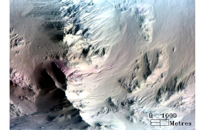
Mean sea level time series
GPS Buoy Altimetry Calibration
GPS Only   Tightly coupled GPS/INS

Output Parameters:    Output Parameters:
Latitude              Latitude
Longitude             Longitude
Ellipsoidal Height    Ellipsoidal Height
                      Pitch
                      Roll
                      Yaw
Conclusion
• GPS observations are difficult in a
  complex dynamic environment.

• Loss of satellite lock affects the
  smoothed solution considerably.

• GPS/INS buoy has the potential to
  improve sea surface height observations.
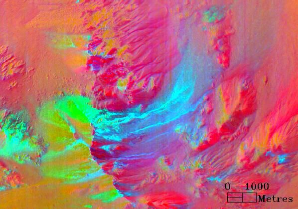
Blue on the Red Planet
An investigation into the formation and
composition of gully features within Hale Crater,
Mars, and the presence of water.

Elyse Allender
Bachelor of Surveying and Spatial Sciences with Honours
Study Site: Hale Crater
Gully Characteristics

       Alcove

       Flow Channel

       Debris Apron
Data Collection Mars Reconnaissance Orbiter (MRO) – operated by NASA, launched 2005 Compact Reconnaissance Imaging Spectrometer for Mars (CRISM) Spectral resolution = 544 image bands Spatial resolution = 18 m per image pixel. Ground coverage = 10 km by 10 km. High Resolution Imaging Science Experiment (HiRISE) Spatial resolution = 0.3 m per image pixel. Ground coverage = 6km swath width.
Data Processing

           N

                    Raw signature

                  Processed signature
Summary Products
N
BD2290
Indicative of Fe/Mg
phyllosilicates (clays)
N
BD2500
Indicative of carbonatesBrowse Product MAF
NHiRISE Image HiRISE DEM: 17 m resolution
Data Combination and Interpretation
                      N

Browse Product: TRU
     R: 0.600 µm
     G: 0.530 µm
     B: 0.440 µm
                                      N
N
R: SINDEX
G: BD2100
B: BD1900
Browse Product: HYD
NN
R: OLINDEX2
G: LCPINDEX
B: HCPINDEX
Browse Product: MAF
NMacquarie Island Tide Gauge Calibration Anna R. Hill Bachelor of Surveying and Spatial Sciences (Honours)
Background
• At Macquarie Island it is known that sea-level is
  rising and that this is exacerbated by land level
  subsidence...tide gauge calibration
• MSL rise has severe implications for the natural
  environment (extreme events and socio-economic
  impacts)

  Watson et al (2010)                       Scott Johnson, 2009
Macquarie Island
In Situ Methodology

Watson et al (2008)
Results

SSHBuoy = α SSHTG + β
Results

   SSHBuoy = α *SSHTG + β + γ *e(ν*STDTG)
Parameter     Watson et al (2008)       Current
scale (α)      0.9879 ± 0.0011      0.9885 ± 0.0010
offset (β)     0.0611 ± 0.0056      0.0442 ± 0.0035
    γ          -0.0117 ± 0.0022     -0.0034 ± 0.0003
    ν             9.88 ± 0.64         14.26 ± 0.39
Thank You
• Dr Christopher Watson
• Henk Brolsma (AAD)
• Roger Handsworth
Questions
• arhill0@utas.edu.auAbsolute Spatial Accuracy of the Cadastral Index within the LIST Martin Gray Bachelor of Surveying and Spatial Sciences
The LIST
Cadastre
• Digitised from 1:5,000 and 1:25,000
  topographic map series
• Later updated with survey data
Project Aims
• Investigate the expected spatial accuracy of
  the LIST
• Show how the accuracy has increased over
  time
• Why the errors are present
Development of the Cadastre
                             ±5-12m
Digitised from 1:5,000 and             Upgraded with survey title
   1:25,000 map series                       information

                                              ±5m

                             ±0.1-5m
                                       Introduction of Survey Act
    Current Cadastre
                                                  2002
Types of Cadastres • Graphical – Visual way of representing the cadastre only – Accuracy between ±0.1m and ±5m • Numerical – Bearing and distance information along lines – Least Squares adjustments – Accuracy
Case Studies
• Glebe Hill
• Acton Park
• White Beach
Different Accuracies in the LIST
Coordination of Boundaries
• Glebe Hill
  – Average difference – 0.040m
• Acton Park
  – Average difference – 0.607m
• White Beach
  – Average difference – 1.543m
Results Summary
• Accuracy of each parcel was found to better
  than stated by the LIST
• Glebe Hill had better accuracy than EPU
• Acton Park was found to have a simplified
  boundary causing one large difference in
  coordinates.
• White beach accuracy was better than
  expected also.
Acton Park
Acton Park
Acton Park
Glebe Hill
Acton Park
White Beach
Conclusion
• The older a property is, the greater the
  uncertainty
• The Surveyors Act 2002 caused a significant
  increase in accuracy
• Introduction of Digital Lodgement and Digital
  Numerical Cadastral Database will further
  improve the accuracy
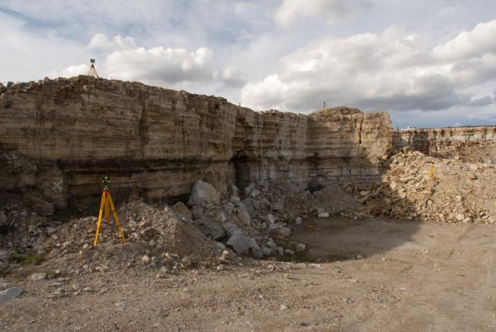
Laser Scanning vs.
Photogrammetry for Mapping
Rock Faces

Daniel Dear
Bachelor of Surveying and Spatial Sciences
Introduction
• White rock quarry,
  Leslievale, Kingborough

• Lester Franks

• Aim to compare:
  1.   Accuracy
  2.   Operational differences
  3.   Future prospects
  4.   Mapping geology
Laser Scanner
Photogrammetry

Left                    Right

             5m
Photogrammetry
Together3D Model
Profile ‘A’
1m Grid Slices
1                                                     Profiles
                          44.5

                          44.3

                          44.1

                                                                                                 Upper
                          43.9                                                                   overhang
South from 5242000N (m)

                          43.7

                          43.5
                                                                                                     5normal

                          43.3         Recess                                                        converge
                                                                                Lower overhang

                          43.1                                                                       5norm_conv

                                                                                                     2normal
                          42.9                                 Smooth section
                                                                                                     laser
                          42.7

                          42.5
                                 261            262   263   Height (m)    264             265                   266
2 Operational Differences
Laser Photogrammetry
• Faster in processing • Faster in the field
• More expensive • Always needs accurate
• Can be vehicle mounted ground control
with RTK – GPS position • Higher resolution
• Textured3 Future prospects
• Laser
– Faster
– Lighter
– Auto render image
– Multi-spectral
– Higher resolution
• Photogrammetry
– Faster processors
– GPS built-in
– Gyro built-in4 Volumes
2.156
2.154
• Potential over- 2.152
estimations up to 30m3 2.15
m^3
2.148
• Laser not the smallest 2.146
as expected. 2.144
– 7m3 2.142
– Due to lower resolution 2.14
2.1384 Mapping Geology
SUMMARY FINDINGS
1. More images, more         4. Near future shows gap
   accurate                     narrowing

2. Shorter baseline, more    5. Lower resolution over-
   accurate                     estimates volume

3. Laser faster in office,   6. 3D models great for
   slower in field              geological feature
                                study
You can also read