Copernicus Land Monitoring Service products around tree cover and forest -Status and - REDDCopernicus
←
→
Page content transcription
If your browser does not render page correctly, please read the page content below
C o p e r n i c u s L a n d M o n i to r i n g
S e r v i c e p ro d u c t s a ro u n d t re e
c o ve r a n d fo re st – S tat u s a n d
outlook

Land Monitoring
                  EO for European Sustainable Forest Management –
                  webinar. 24th September 2020
                  Tobias Langanke: tobias.Langanke@eea.Europa.eu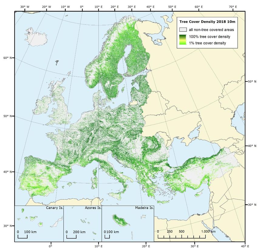
Copernicus Land Monitoring service – context
  Land       •   CLMS (Copernicus Land Monitoring Service) implemented by the European Environment Agency
Monitoring
                 (EEA) and the Joint Research Centre (JRC)
             •   CLMS provides operational products and services, derived from satellite imagery and produced
                 by industry
             •   Products and services are made available, free and open through the Copernicus land portal
                 https://land.copernicus.eu/ both as view service, web map services and for download.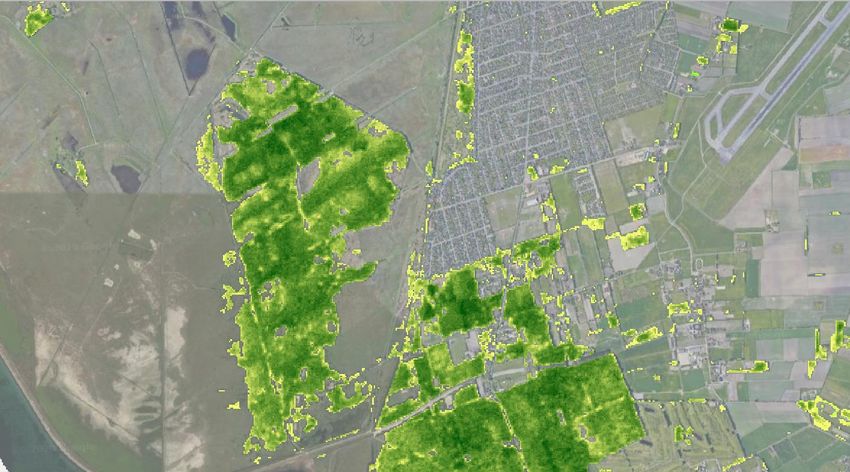
CLMS products with tree cover/forest relevance
Land
Monitoring 1. High Resolution Layer (HRL) Forest (2012, 2015, 2018), 20m
resolution until 2015, 10m since 2018
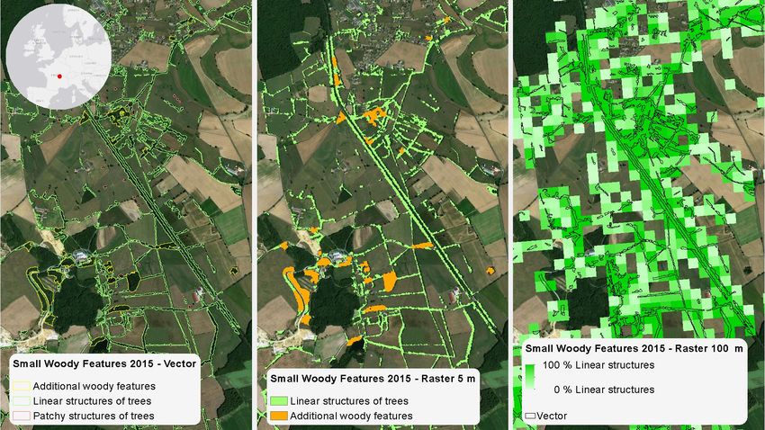
2. Small Woody Features (SWF) 2015 (2018 in planning) (Vector, 5m
raster and 100m raster)
3. Components of Riparian Zone products (available only for riparian
zones)
4. Components of future CLC+ Backbone vector and raster products (in
production for 2018 reference year) and CLC+ Core database
5. Future High Resolution Phenology and Productivity products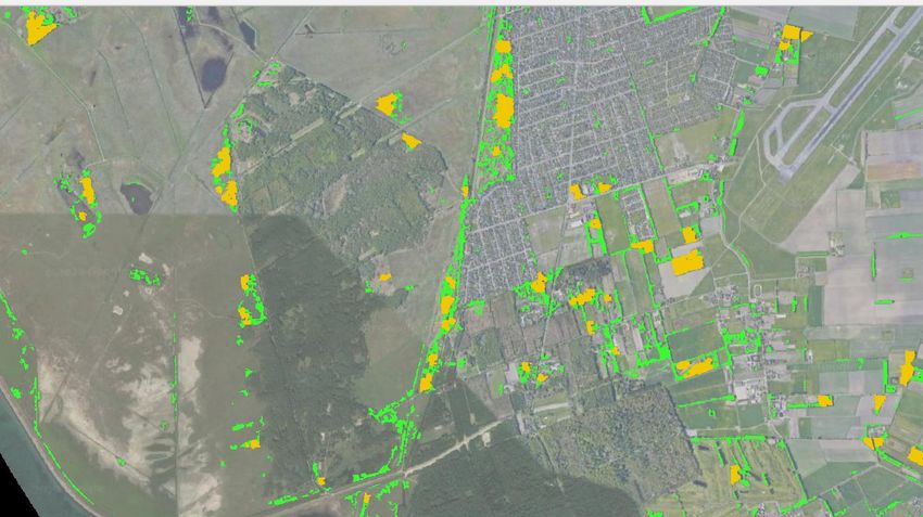
1. HRL Forest
  Land
Monitoring   • Tree cover products as part of the High Resolution Layer (HRL)
               “Forest” exist for 2012, 2015 and 2018 reference years
             • 2018 reference year partly available, Change products, 100m
               products and national projection products October/November
             • “Forest HRL” in reality a “Tree Cover HRL” with ONE approximation
               to FAO forest definition (10% TCD and 0.5 ha MMU filter, and trees
               agricultural and urban context (from CLC) removed)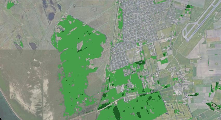
HRL Forest Products
  Land
Monitoring
                                   Available now
                                   Available end
                                   September
                                   Available mid
                                   October
Land
Monitoring
2018 tree cover and Forest products example
  Land
Monitoring
2018 Dominant Leaf Type
  Land
Monitoring
2 0 1 8 Tre e C o v e r D e n s i t y
  Land
Monitoring
2015 Small woody featues (SWF)
  Land
Monitoring
High level concept comparison 2015-2018
  Land
 HRL 2015
Monitoring                                                                     HRL 2018
Based on optical data following a multi-temporal “best-of” scene               Combined SAR/optic approach at 10m resolution using S-1/S-2 times
approach at 20m resolution (Sentinel-2, Landsat 8, ResourceSat-2, SPOT-5)      series in order to exploit the strength of both EO data systems
Semi-automatic sampling approach using HRLs 2012, CLC 2012, JTC                Fully automatic sampling approach (incl. outlier detection) using HRLs
FTYMAP 2006                                                                    2015, CLC 2018, local component products & other ancillary/in-situ data

Set-up of a Forest Reference Database (RDB) for validation and calibration     Revision and densification of the RDB (2012-2015-2018) + set-up of a
(2012-2015)                                                                    Change Calibration Database

Multi-temporal classification approach of satellite data on tile level         Innovative classification approach using time features on region level
(supervised SVM classification)                                                (supervised, RF classification with active learning)
Rule-based data integration of all classification results (data stacks) to a   Automated feature selection of all input data, already combined to one
thematic raster                                                                classification result, accompanied by Confidence Layers

Partial use of other HRLs for optimization and harmonization                   Intended full use of other HRLs and local component products for
                                                                               optimization and harmonization

Semi-automatic processing in a private cloud environment incl. manual          DIAS-based processing (automated and scalable, Big Data production) incl.
enhancements                                                                   semi-automatic enhancements
Evolution of CLMS tree cover and forest products
TCD: Tree Cover Density
Land
DLT: Dominant Leaf Type
Monitoring 2012 2015 2018 FTY: Forest Type
FADSL: Forest Additional Support Layer
TCD 20m TCD 20m TCD 10m DLTC: Dominant Leaf Type Change
TCDC: Tree Cover Density Change
TCD 100m TCD 100m TCD 100m CCD: Coniferous Cover Density
BCD: Broadleave Cover Density
DLT 20m DLT 20m DLT 10m TCCM: Tree Cover Change Mask
DCL: Derived Correction layers
RD: Reference database layers (absolute calibration and
FTY 20m FTY 20m FTY 10m change calibration)
PUL: Production Unit Layer
FTY 100m FTY 100m FTY 100m TF: Time Features
DSL: Data Score Layer
CL: Classification confidence layers
FADSL 20m FADSL 20m FADSL 10m
DCL PUL TF
DLTC 2012-2015 DLTC 2015-2018 TCCM 2015-2018
20m 20m 20m DSL RD CL
TCDC 2012-2015 CCD 100m BCD 100m
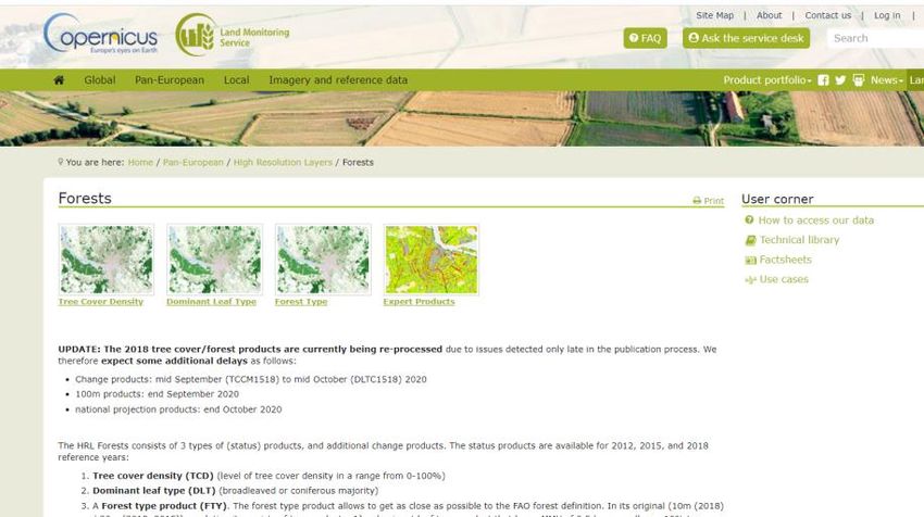
100m 2015&2018 2015&2018HRL Forest – where to get the data and more info
Land
Monitoring • https://land.copernicus.eu/pan-european/high-resolution-
layers/forests2. Small Woody Features (SWF
Land
• Contains woody linear
Monitoring
and small patchy
elements, limited on
basis of geometric
characteristics
• derived by combination
of (semi-automated)
image segmentation,
feature extraction and
classification and/or
morphological analysis,
or manual editingE xa m p l e LU / LC m a p p i n g : S m a l l Wo o d y Fe a t u re s ( S W F ) Land Monitoring
3. Riparian Zones
  Land
Monitoring   • Local component product that contains a detailed LC/LU mapping
               along rivers
             • Some more detailed forest classes mapped
4. CLC+ product suite –under development
Land
Monitoring • CLC+ is the suite of products under development of the CLC 2nd
Generation approach.4. CLC+ Backbone (in production)Class Nomenclature
Land Domain
Monitoring Ref.: Barbara Kosztra,
CLC Gebhard Banko 23.04.2020
Land Cover
backbone
Raster Vector
ID RASTER-classes
1 Sealed (buildings and flat sealed surfaces)
2 Woody – needle leaved trees
3 Woody – broadleaved, deciduous trees
4 Woody – broadleaved, evergreen trees
5 Woody – shrubs
6 Permanent herbaceous (i.e. grasslands)
7 Periodically herbaceous (i.e. arable land)
8 Lichens and mosses
9 Sparsely vegetated
10 Non-vegetated (i.e. rock, screes, sand, lichen,
permanent bare soil)
11 Water
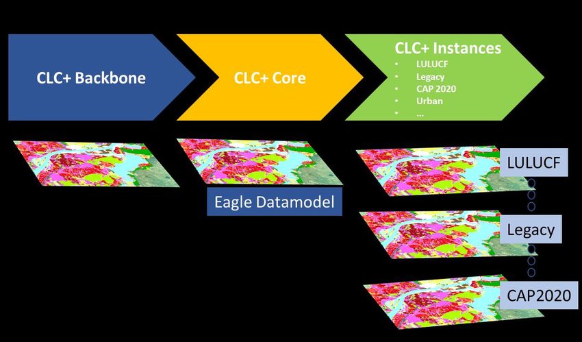
12 Snow and iceCLC+ Core – Overview
Land
Monitoring
CLC+ CORE: consistent
multi-use grid database
repository populated with
a broad range of land
cover, land use and
ancillary data from the
CLMS and other sources,
forming the information
engine to deliver and
support tailored thematic
information
requirements.The EAGLE ontology Land Monitoring
5. Future High Resolution Vegetation Phenology and Productivity
  Land
Monitoring   High Resolution Phenology products with two main
             products:
             • Seasonal trajectories: The reconstructed vegetation
                index time-series, which are input to the phenology
                detection. e.g. daily, 10-day, monthly, and yearly upon
                                                                               HR Phenology
                user’s request.
             • Phenology parameters: Dates and values at Start of
                Season (SOS), End of Season (EOS) and seasonal
                maximum, length of the growing season (LOS),
                amplitude, base value, and seasonal integral values.
                                                                                    © Markus Probeck
For comprehensive overview of CLMS products see
https://land.copernicus.eu/product-portfolio/overview
Land
MonitoringWa n t t o k n o w m o r e ? L i n k s a n d r e s o u r c e s
Land
Copernicus portal (for the whole programme) https://www.copernicus.eu
Monitoring
Copernicus Land portal: Current main portal for information and https://land.copernicus.eu
data view/download from the Land Service
Copernicus product search engine at EC - product search across https://services-portfolios.copernicus.eu/
all services
Search for data and information at EEA (European Environment http://search.apps.eea.europa.eu
Agency)
EEA data and maps. Includes dashboards (interactive data https://www.eea.europa.eu/data-and-
viewers) with links to maps and indicators (under development; maps/dashboards
land-take already published)
GEOSS portal: online map-based user interface (discover and http://www.geoportal.org/
access EO data) with global focus
EU open Data portal https://data.europa.eu/euodp/data/
Information on DIAS (Data and Information Access Services). https://www.copernicus.eu/en/access-
DIAS will provide centralised access to Copernicus data, data/dias
information, and processing tools.Land
Monitoring
Thank youYou can also read