FEMA Floodplain Changes in Alexandria - HOLMES RUN PRELIMINARY Map Revisions Available - City of ...
←
→
Page content transcription
If your browser does not render page correctly, please read the page content below
FEMA Floodplain Changes
     in Alexandria
 PRELIMINARY Map Revisions Available

         Brian Rahal, PE, CFM
 T&ES Stormwater Management Division

            HOLMES RUN
           June 29th, 2021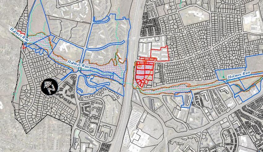
FEMA Floodplain Changes
         in Alexandria

City outreach meetings:

• March 1, 2021 – FEMA Map Changes Open House
• May 19, 2021 – Four Mile Run
• May 24, 2021 - Potomac River / Old Town / Waterfront
• June 2, 2021 - Hooffs Run
• June 7, 20201 - Cameron Run, Backlick Run, Strawberry
Run, Taylor Run
• June 29, 2021 - Holmes Run

                                                          2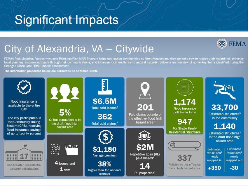
National Flood
         Insurance Program

Quick Facts:
• Established in 1968
• Alexandria began participation in 1969
• Alexandria’s first Flood Insurance Rate Map (FIRM) was
  published in 1969
• Mandatory Flood Insurance began in 1973
• Alexandria began participation in the Community
  Rating System (CRS) in 1992 (Flood Insurance
  discounts)
• Last update to Alexandria’s maps became effective on
  June 16, 2011

                                                           3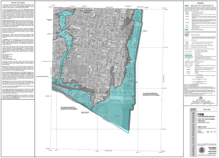
What are the FEMA
         Flood Maps?
The regulatory FEMA floodplain, is
officially shown on FEMA’s published
maps, also known as:
FLOOD INSURANCE RATE MAPs
(FIRMs)
Alexandria has 10 FEMA map panels

                                       4
What are the FEMA
  Flood Maps?

                    5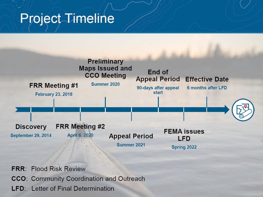
What is the FEMA Floodplain?
The regulatory FEMA floodplain, as
shown on the maps, is known as:
Zone AE: An area inundated by 1%
annual chance flood, for which Base
Flood Elevations (BFEs) have been
determined by detailed methods (H&H).
Other zones defined by flooding source.
AKA: Special Flood Hazard Area (SFHA),
100-year floodplain.
                                          6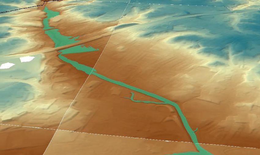
Alexandria’s Floodplains
Effective June 16, 2011

   Digital FIRM – On City GIS Map
                                    7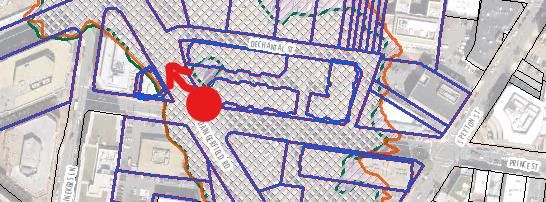
Alexandria’s Floodplain
Administration by Ordinance
• Alexandria’s Floodplain District
 • Zoning Ordinance:            ARTICLE VI – SPECIAL AND OVERLAY
   ZONES, Section 6-300 Floodplain District

• Regulation of Development
 • Development:
 “Any man-made change to improved or unimproved real estate, including, but
 not limited to, the construction of buildings or other structures, the placement
 of manufactured homes, the construction of streets, the installation of utilities
 and other activities or operations involving paving, filling, grading,
 excavating, mining, dredging or drilling, the storage of equipment or
 materials.”

                                                                                     8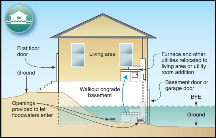
Regulation of Development
When does the Ordinance apply?

• New Construction in Floodplain
 • Always

• Existing Buildings in Floodplain
 • Substantial Improvement:
   • Any repair, reconstruction, rehabilitation, addition or
     other improvement of a building or structure, the
     cost of which equals or exceeds 50% of the market
     value of the building or structure.
 • Any improvements to Substantially Damaged
   buildings or structures.
 • Historic buildings are exempt.

                                                               9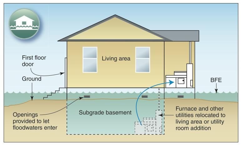
Regulation of Development
• Three Major Uses:

  • Residential Building
     • Any single-family dwelling, two-family dwelling, row or townhouse
       dwelling, or multi-family dwelling, and any accessory building or
       structure. Floodproofing underground spaces (basement/parking) is
       not permitted.

  • Nonresidential Building
     • Any building or structure which is not a residential building or a mixed-
       use building. Floodproofing underground spaces (basement/parking) is
       permitted.

  • Mixed-Use Building
     • Any building or structure that is used or intended for use in a mixture
       of nonresidential and residential uses in the same building or
       structure. For floodplain management purposes, a mixed-use
       building is subject to the same rules and conditions as a
       residential building unless all of the provisions set forth more
       specifically in Section 6-305(K) are met. Floodproofing is conditional.

                                                                                   10
How often are the maps updated?
• Depends! Alexandria’s maps were last
updated in June 2011.
• Previous map dates:
• 1991
• 1983
• 1981
• First mapped in 1969
11NEW MAPS ARE COMING
Schedule:
WE ARE HERE
September 30, 2020
12Citywide Impacts
• Based on PRELIMINARY maps (FEMA)
13Property Impacts
Properties New to the Floodplain:
• Insurance is mandatory for government backed
mortgages.
• Average annual premium in Alexandria is $1,180/yr.
• Elevation certificates may be required by
mortgage holders.
• $400-$600 One-time expense.
• Any development of property (including
additions, interior work) now subject to
Substantial Improvement floodplain regulations.
• Nonresidential redevelopment may dry-
floodproof.
• Won’t be impacted until maps become Effective
in Fall 2022.
14Property Impacts
Basic Floodplain Regulations:
• All New and Substantially Improved
buildings must have the lowest floor
(including basements) at least 1-ft above
the Base Flood Elevation (BFE).
• Substantial Improvement means any
improvement to a building, the cost of
which is 50% or greater than the Value of
the building. (city uses tax assessed data)
15Property Impacts
Examples of older buildings with
basements made compliant with
regulations. (Only required if substantially improved).
16Property Impacts
Examples of older buildings with
basements made compliant with
regulations. (Only required if substantially improved).
17FEMA Floodplains in
Alexandria
• Re-Delineation – All
flood data /
information developed
for the 2011 maps
remain the same.
Base Flood Elevations
are the same.
Boundaries re-
delineated on latest
LiDAR mapping
available.
18FEMA Floodplain in
Holmes Run Watershed
Mapping methods result in slight changes to boundary.
2011
2020 (Prelim)
19FEMA Floodplain in
Holmes Run Watershed
Mapping methods result in slight changes to boundary.
2011
2020 (Prelim)
20More Information?
Resources for more information:
City Website:
https://alexandriava.gov/floodmap
https://alexandriava.gov/933446 (flooding & drainage)
FEMA MAP UPDATE:
https://arcg.is/1L4fXW
Flood Insurance:
• Your Homeowner’s Insurance Provider
• FEMA: https://floodsmart.gov
• Renter’s insurance also available for belongings!
• https://www.floodsmart.gov/flood-insurance/types
FEMA’s RISK Rating 2.0:
https://www.fema.gov/flood-insurance/work-with-
nfip/risk-rating
COMING SOON: Explore City 50% matching
grants for Floodproofing your property! City
reimburses up to $5,000 for qualified projects.
https://www.alexandriava.gov/FloodAction
21KEY TAKE-AWAYS
• MAP changes are coming!
• Take steps to protect yourself and your property.
• Get Flood Insurance Now!
• If you are NOW in Zone X, flood insurance policies prior
to map change will be grandfathered in at Zone X rates
when the map change becomes effective.*
• 30-day waiting period for policy coverage. Don’t wait!
• Floodproofing 50% matching grants up to $5,000
coming soon from the City. Watch for updates at
https://alexandriava.gov/floodaction
* First 12-months. Not to increase annually more than 18%.
22What’s Next?
City continues community outreach for next phase of map
change process - Appeals.
Appeal Period begins Summer 2021 for 90-days. Dates TBD.
FEMA sends Letter of Final Determination (LFD) in Spring
2022.
FEMA makes new maps effective 6-mo following LFD in Fall
2022. Any previous Letters of Map Change/Amendments will
be validated against the new maps at this time, as appropriate
by FEMA.
23APPEALS PROCESS
FEMA Issues Public Invitation to Appeal or Comment
(COMING SOON!)
Residents may submit an appeal if they perceive that modeling
or data used to create the map is technically or scientifically
incorrect.
• An appeal must include technical information, such as
hydraulic or hydrologic data, to support the claim.
• Appeals cannot be based on the effects of proposed projects
or projects started after the study is in progress.
• If property owners see incorrect information that does not
change the flood hazard information—such as a missing or
misspelled road name in the Special Flood Hazard Area or an
incorrect corporate boundary—they can submit a written
comment.
More information on dates for the appeals period coming soon.
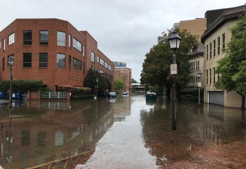
24Questions?
Dangerfield Rd @ Prince St
September 10, 2020
25You can also read