Mediterranean Sea level variations during the Messinian salinity crisis
←
→
Page content transcription
If your browser does not render page correctly, please read the page content below
Mediterranean Sea level variations during the Messinian
                       salinity crisis
                                      J. Gargani, C. Rigollet

     To cite this version:
    J. Gargani, C. Rigollet. Mediterranean Sea level variations during the Messinian salinity crisis. Geo-
    physical Research Letters, American Geophysical Union, 2007, 34, pp.l10405. �hal-00376531�

                                 HAL Id: hal-00376531
                https://hal.archives-ouvertes.fr/hal-00376531
                                     Submitted on 2 Jun 2021

    HAL is a multi-disciplinary open access            L’archive ouverte pluridisciplinaire HAL, est
archive for the deposit and dissemination of sci- destinée au dépôt et à la diffusion de documents
entific research documents, whether they are pub- scientifiques de niveau recherche, publiés ou non,
lished or not. The documents may come from émanant des établissements d’enseignement et de
teaching and research institutions in France or recherche français ou étrangers, des laboratoires
abroad, or from public or private research centers. publics ou privés.
                                              Copyright
GEOPHYSICAL RESEARCH LETTERS, VOL. 34, L10405, doi:10.1029/2007GL029885, 2007
Mediterranean Sea level variations during the Messinian salinity crisis
Julien Gargani1,2 and Christophe Rigollet3
Received 3 March 2007; revised 17 April 2007; accepted 25 April 2007; published 31 May 2007.
[1] The Mediterranean Basin has not always been [3] Based on sedimentological analyses, seismic line
connected to the Atlantic Ocean. During the Messinian observations and paleoriver reconstructions, it is suggested
salinity crisis (MSC), the Mediterranean Sea became that at least two significant falls of Mediterranean water
progressively isolated by a complex combination of level [Rouchy and Saint-Martin, 1992] took place in the
tectonic and glacio-eustatic processes. When isolated, the Western [Gargani, 2004; Lofi et al., 2005] and in the Eastern
Mediterranean water level depends on the hydrological flux [Druckman et al., 1995] Basin. The amplitude of these sea
and is expected to vary significantly. The amplitude and level falls was estimated to be in the order of 500 m and
number of large water level fluctuations in the isolated 1500 m in the Western Basin, by analyses of the slope
Mediterranean is still controversial, despite numerous break of the paleorivers profiles [Gargani, 2004].
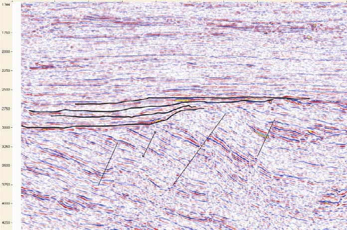
geological investigations. The observation of 3 – 5 surfaces [4] Various erosional surfaces (3 – 5) are observed in
of erosion in the Nile delta (Eastern Basin) provides new seismic profiles along the Egyptian margin at a depth
elements for understanding the dynamics of the MSC. Our between 2500 and 3000 m (Figure 1). Considering
model demonstrates that numerous water level falls of short the Plio-Quaternary subsidence that ranges between 750–
duration may explain the preservation of a discontinuous 1000 m (see Figure 1b), northwards of the Egyptian Hinge
river profile at 500 m and 1500 m in the Western Line, these surfaces must have been formed during the MSC
Basin, as well as the existence of deep surfaces of erosion in at a depth of 1500– 2250 m beneath the present-day sea
the Eastern Basin. Citation: Gargani, J., and C. Rigollet level of the Eastern Mediterranean basin. So far, these data
(2007), Mediterranean Sea level variations during the Messinian are not explained by previous theories or models.
salinity crisis, Geophys. Res. Lett., 34, L10405, doi:10.1029/
2007GL029885. 2. Model and Methods
[5] To understand the history of Mediterranean water
1. Introduction level fluctuations in more detail, it is necessary to take into
[2] The Messinian salinity crisis (MSC) is synchronous account precipitation, evaporation and river discharge
over the entire Mediterranean basin, dated to have started at [Blanc, 2000; Meijer and Krijgsman, 2005], but also
5.96 million years ago [Krijgsman et al., 1999]. The eustatic variations and uplift rate of the threshold between
beginning of the MSC does not correspond to a major peak the Atlantic Ocean and the Mediterranean Sea. Basically,
in the open-ocean benthic d 18O signal [Krijgsman et al., the model sums the water inflow and outflow into the
1999; Hodell et al., 2001], which is commonly interpreted Mediterranean basins [Meijer and Krijgsman, 2005]. At a
to reflect glacio-eustatic sea-level changes. The MSC was given time, the Mediterranean basin can be connected or not
thus not associated with a major climate change [Warny et to the Atlantic Ocean. This depends from the sea level of the
al., 2003]. Furthermore, the tectonic uplift (1 km) that was Atlantic Ocean ZAtlantic(t) and from the altitude of the
assumed to have occurred between 6.3 and 4.8 Myr ago in threshold area Zthreshold(t) between the Atlantic Ocean
the area of the present Gibraltar Strait, argues in favour of a and the Mediterranean Sea. The glacio-eustatic variations
dominantly tectonic origin for the Messinian crisis [Duggen ZAtlantic(t) are in competition with the uplift rate Uthreshold of
et al., 2003]. Isolation from the Atlantic Ocean was estab- the threshold area between the Atlantic Ocean and
lished between 5.59 and 5.33 million years ago [Krijgsman the Mediterranean Sea to allow the Atlantic water to flow
et al., 1999], causing a large fall in Mediterranean water into the Mediterranean Basin. If ZAtlantic(t) > Zthreshold(t)
level of 1500 –2500 m [Ryan et al., 1973; Barber, 1981; (Zthresshold(t) = Uthreshold.t + Zinit, where t is the time and Zinit
Clauzon, 1982; Guennoc et al., 2000]. The MSC finished the initial altitude of the threshold), the Mediterranean
when eastward regressive erosion opened the Gibraltar sea is connected to the Atlantic. In consequence, the
Strait [Blanc, 2002]. Despite the progress in our knowledge Mediterranean Sea level is identical to the Atlantic Sea
about the chronology of the MSC, some uncertainties still level ZMediterranean(t) = ZAtlantic(t). If ZAtlantic(t) < Zthreshold(t),
exist. For instance, we don’t know precisely the number of the Mediterranean is isolated from the Atlantic. Under this
Mediterranean water level falls and their amplitude, during condition, the Mediterranean Sea level ZMediterranean(t)
the isolation phase. depends from the water budget. The water budget is
calculated at each time step (1 kyr) taking into account
the temporal variations of the water inflow (precipitation,
1 river discharge) and outflow (evaporation). Basically, the
Laboratoire Géodynamique des Rifts et des Marges Passives,
Université du Maine, Le Mans, France. variation of the volume of the Mediterranean is given by
2
Now at Institut Français du Pétrole, Rueil-Malmaison, France. DVMediterranean(t) = [P(t) + E(t) Q(t)]. A(ZMediterranean(t)).t,
3
Gaz de France, Saint-Denis, France. where P(t), Q(t) and E(t) are respectively the precipitation
rate, the river discharge and the evaporation rate by unit
Copyright 2007 by the American Geophysical Union. area. A(ZMediterranean(t)) is the area of the Mediterranean Sea
0094-8276/07/2007GL029885
L10405 1 of 5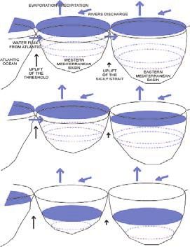
L10405                     GARGANI AND RIGOLLET: WHEN THE MEDITERRANEAN WAS A YOYO                                           L10405

Figure 1. Seismic line of the Egyptian margin showing (a) surfaces of erosion (horizontal scale: 1 horizontal grid =
1250 m) and (b) the 750 – 1000 m of post messinian tectonic along the hinge line of the Egyptian margin (horizontal scale:
1 horizontal grid = 2000 m).

when the sea level is ZMediterranean(t). The area of the              Eastern Basin are simulated respectively by the equations
Mediterranean Sea A(ZMediterranean(t)) is approximates by             A(ZW-Med(t)) = (ZW-Med(t)  Z0W)/aW and A(ZE-Med(t)) =
the linear relation:                                                  (Z E-Med (t)  Z 0E )/a E, where Z 0W, Z 0E , a W, a E are
                                                                      constants giving the geometry of the Western and Eastern
         AðZMediterranean ðtÞÞ ¼ ðZMediterranean ðtÞ  Z0 Þ=a   ð1Þ   Basins.
                                                                        [7] Oxygen isotopic-based sea-level estimates for the
where a and Z0 are two constants. This approximation is               open-ocean suggest variations of amplitude between
close to the geometry used by Meijer and Krijgsman                    50 m and +50 m during the MSC [Miller et al., 2005].
[2005]. Considering this geometry for the Mediterranean               To model the temporal glacio-eustatic variations (open
Basin, the area variation with time is of the form                    ocean) Zeustatic(t), an insolation curve is used [Gargani
A 2 (Z Mediterranean (t + 1)) = A 2 (Z Mediterranean (t))            et al., 2006] even if this approximation may produce some
2DV Mediterranean (t + 1)/a. The Mediterranean sea                    discrepancy with real sea level variation. The amplitude of
level ZMediterranean(t) is calculated at each time step using         the simulated glacio-eustatic variation is comprised between
equation (1).                                                         50 m and +50 m.
  [6] The Western and the Eastern Basin may have                        [8] The hydrological flux (precipitation, evaporation)
become independent during water level lowstand, sepa-                 estimated by a palynological analysis for the Messinian
rated by the Sicily threshold ZSicily-thr(t). When the sea            times [Fauquette et al., 1999; Fauquette et al., 2006]
level of the Western Basin is smaller than the Sicily                 suggests that climatic and hydrological conditions are close
threshold (ZW-Med(t) < ZSicily-thr(t)), the variation of the          to the present one. It is not necessary to suppose extreme
sea level in the Western and Eastern Basins became                    hydrological fluxes to obtain a significant water level fall. A
independent. The area variations of the Western and                   value comprised between 0.5 and 1 m/yr for Evaporation

                                                                 2 of 5
L10405 GARGANI AND RIGOLLET: WHEN THE MEDITERRANEAN WAS A YOYO L10405
Figure 2. As no major climate change has been documented during the MSC [Warny et al., 2003], the same range of value
can be considered for the evaporation, precipitation, and rivers discharge during the MSC as during the present time. Small
climatic variations can be expected, due to the variation of insolation, as during the Quaternary times. We use the insolation
curve (65°N, July 1st) to simulate the temporal variation of open ocean sea level as well as of E-P (Evaporation-
Precipitation) and the variation of river discharge [Gargani et al., 2006]. We assume that the variations of the hydrological
flux with time, due to global climate change, are no more than 25% from the present value. (a) Conceptual model.
(b) Evaporation E minus Pluviometry P in the Mediterranean Basin during the MSC. The mean temperature and
precipitation were of the same order during the MSC as today. In the present time, E-P range between 0.5 and 1 m/an
[Meijer and Krijgsman, 2005]. The evaporation and precipitation by unit area are considered identical in the Western and
Eastern Basins [Meijer and Krijgsman, 2005]. (c) River discharge in the Western and Eastern Basin. We conserve the same
order of the present river discharge [Meijer and Krijgsman, 2005].
minus Precipitation is considered (Figure 2). The river and river discharge when the Mediterranean was isolated
discharge is around 15000 m3/s in the Eastern basin and from the Atlantic Ocean. Roveri and Manzi [2006] have
7500 m 3 /s in the Western basin. The variation of suggested that 3– 4 cycles could be recognized across the
evaporation, precipitation and river discharge due to different Mediterranean basins. Furthermore, the existence
astronomical forcing are approximated using the temporal of fossil fishes in the upper interval of the ‘Lago-Mare’
variation of the insolation curve. The amplitude of these event in Cava Serredi (Tuscany, Italy) implies an intra-
variations is assumed to be of ±25% of the average value. Messinian marine refilling [Carnevale et al., 2006]. The
eight ‘Lago-Mare’ cycles in the sediment of the Nijar Basin
3. Results and Discussion (SE Spain) also suggests a repeatedly fluctuating water level
instead of one major desiccation event during the Late
[9] According to our modelling, numerous and brief Messinian episode [Fortuin and Krijgsman, 2003]. The
water level fluctuations may have occurred at 500 m, 2000 m lowstand duration has certainly been long
then at 1500 m in the Western Mediterranean Basin enough to allow 3 – 5 phases of erosion, as well as to allow
(Figure 3) associated with an uplift rate of 0.667 mm/yr the incision of numerous messinian valleys on the Egyptian
[Duggen et al., 2003] of the threshold between the Atlantic margin. Our results suggest that it may have a duration of
Ocean and the Mediterranean Sea (possible values range 60 – 80 kyrs. To our knowledge, this duration is not
from 0.75 mm/yr to 0.3 mm/yr). The abrupt increase in the constrained by isotopic method. The different detritic fans
ratio of continental- versus marine-derived palynomorphs observed in the Nile delta (Qawasim and Abu Madi) may
that indicates that restriction of Atlantic inflow intensified at also be a consequence of the change of location and of
5.4 Myr [Warny et al., 2003] could be interpreted duration of the erosion due to the various Mediterranean
adequately by this approach. This scenario can also explain water level falls during the MSC.
the slope break observed in the rivers paleoprofiles of the [10] The duration and the number of lowstand of the
Gulf of Lions: our model suggests that numerous sea level Mediterranean Sea level depend of the altitude and of the
falls at various depths have happened. The model uplift rate of the ‘‘Gibraltar’’ and Sicily thresholds (see
furthermore allows interpretation of the 3 – 5 phases of auxiliary material).1 The amplitude of the Mediterranean
erosion observed on the Egyptian margin (Eastern Basin), Sea level in the Western and Eastern Basins depends from
as well as the large regressive erosion that affected the River the water budget. An approximation of ±25% of the value of
Nile starting from a lowstand at 2000 m during the
MSC. The 3 –5 phases of erosion are a consequence of
climatic variations that affected evaporation, precipitation 1
Auxiliary materials are available in the HTML. doi:10.1029/
2007GL029885.
3 of 5L10405 GARGANI AND RIGOLLET: WHEN THE MEDITERRANEAN WAS A YOYO L10405
Figure 3. Mediterranean water level variation for the Western (green line) and the Eastern Basins (red line). The uplift rate
Uthreshold is of (a) 0.30 mm/yr and (b) 0.667 mm/yr (1 km in 1.5 Myr) [Duggen et al., 2003] for the area between the
Atlantic Ocean and the Mediterranean Sea. We consider a small rate of uplift (30 m/Myr) for the Sicily threshold during the
MSC [Patriat et al., 2003]. A calibrated insolation curve calculated at 65°N, July 1st, is used to simulate the glacio-eustatic
variations of amplitude comprised between 50 m and +50 m, during the MSC [Miller et al., 2005], due to global climate
change. We also use the insolation curve to simulate the hydrological flux [Gargani et al., 2006]. The geometry of the two
basins is taken into account as in the study of Meijer and Krijgsman [2005]. We assume a bathymetry Zinit = 380 m for
the threshold between the Mediterranean Sea and the Atlantic Ocean, and of 35 m for the threshold between the Western
and the Eastern Basins. This model allows an interpretation of the existence of 3 – 5 cycles in the sediments, as well as the
observable lowstands in rivers profiles. aW = 4461.5 1012 m1, aE = 2275.8 1012 m1, a = 1628 1012 m1, Z0W =
3123 m, Z0E = 3613 m, Z0 = 3581 m.
evaporation, precipitation and river discharge induce an Druckman, Y., B. Buchbinder, G. M. Martinotti, R. Siman Tov, and
uncertainty of ±10% on the estimation of the sea level P. Aharon (1995), The buried Afiq Canyon (eastern Mediterranean,
Israel): A case study of a tertiary submarine canyon exposed in
equilibrium. This approach allows an estimate of the late Messinian times, Mar. Geol., 123, 167 – 185.
consequences of climate (water inflow and outflow) Duggen, S., K. Hoernie, P. van den Bogaard, L. Rüpke, and J. Phipps
and of the uplift rate of the various thresholds on the Morgan (2003), Deep roots of the Messinian salinity crisis, Nature,
Mediterranean Basin during the Messinian times. 422, 602 – 606.
Fauquette, S., J.-P. Suc, J. Guiot, F. Diniz, N. Feddi, Z. Zheng, E. Bessais,
and A. Drivaliari (1999), Climate and biomes in the west Mediterranean
during the Pliocene, Paleogeogr. Palaeoclimatol. Palaeoecol., 152, 15 –
4. Conclusion 36.
Fauquette, S., et al. (2006), How much did climate force the Messinian
[11] Our model suggests that numerous sea level fall of salinity crisis? Quantified climatic conditions from pollen records in the
large amplitude may have happened during the Messinian Mediterranean region, Palaeogeogr. Palaeoclimatol. Palaeoecol., 238,
281 – 301.
salinity crisis in accordance with seismic data. It explains Fortuin, A. R., and W. Krijgsman (2003), The Messinian of the Nijar
why 3– 5 phases of erosion are observed in the deep basin. Basin (SE Spain): Sedimentation, depositional environments and
It could be the starting point for a better understanding of paleogeographic evolution, Sediment. Geol., 160, 213 – 242.
Gargani, J. (2004), Modelling of the erosion in the Rhone Valley during the
the dynamics of the various Mediterranean sub-basins. For Messinian crisis (France), Quat. Int., 121, 13 – 22.
example, our approach could provide indications about the Gargani, J., O. Stab, I. Cojan, and J. Brulhet (2006), Modelling the long-
mean salinity, the sedimentation rate (evaporates, detritic) term fluvial erosion of the River Somme during the last million years,
and about the geodynamics of the Mediterranean margin Terra Nova, 18, 118 – 129.
Guennoc, P., C. Gorini, and A. Mauffret (2000), La surface d’érosion
and thresholds. messinienne dans le golfe du Lion, Géol. Fr., 3, 67 – 97.
Hodell, D. A., J. H. Curtis, F. J. Sierro, and M. E. Rayno (2001),
[12] Acknowledgments. We would like to thank Paul Meijer and an Correlation of late Miocene to early Pliocene sequences between
anonymous reviewer for constructive comments. Nicolas Nosjean and Wout the Mediterranean and North Atlantic, Paleoceanography, 16(2), 164 –
Krijgsman are also acknowledged for discussion. 178.
Krijgsman, W., F. J. Hilgen, I. Raffi, F. J. Sierro, and D. S. Wilson (1999),
Chronology, causes and progression of the Messinian salinity crisis,
References Nature, 400, 652 – 655.
Barber, P. M. (1981), Messinian subaerial erosion of the Proto-Nile Delta, Lofi, J., C. Gorini, S. Berné, G. Clauzon, A. Tadeu Dos Reis, W. B. F.
Mar. Geol., 44, 253 – 272. Ryan, and M. S. Steckler (2005), Erosional processes and paleo-
Blanc, P.-L. (2000), Of sills and straits: A quantitative assessment of the environmental changes in the western Gulf of Lions (SW France) during
Messinian salinity crisis, Deep Sea Res., Part I, 47, 1429 – 1460. the Messinian salinity crisis, Mar. Geol., 217, 1 – 30.
Blanc, P.-L. (2002), The opening of the Plio-Quaternary Gibraltar Strait Meijer, P. T., and W. A. Krijgsman (2005), Quantitative analysis of the
assessing the size of a cataclysm, Geodin. Acta, 15, 303 – 317. desiccation and re-filling of the Mediterranean during the Messinian
Carnevale, G., W. Landini, and G. Sarti (2006), Mare versus Lago-mare: salinity crisis, Earth Planet. Sci. Lett., 240, 510 – 520.
Marine fishes and the Mediterranean environment at the end of the Miller, K. G., et al. (2005), The Phanerozoic record of global sea-level
Messinian salinity crisis, J. Geol. Soc. London, 163, 75 – 80. change, Science, 310, 1293 – 1298.
Clauzon, G. (1982), Le canyon messinien du Rhône: Une preuve decisive Patriat, M., N. Ellouz, Z. Dey, J.-M. Gailuer, and H. Ben Kilani (2003), The
du desiccated deep-basin model (Hsü, Cita et Ryan, 1973), Bull. Soc. Hammamet, Gabès and Chotts basins (Tunisia): A review of the
Géol. Fr., 24, 597 – 610. subsidence history, Sediment. Geol., 156, 241 – 262.
4 of 5L10405 GARGANI AND RIGOLLET: WHEN THE MEDITERRANEAN WAS A YOYO L10405
Rouchy, J. M., and J. P. Saint-Martin (1992), Late Miocene events in the Warny, S. A., P. J. Bart, and J.-P. Suc (2003), Timing and progression of
Mediterranean as recorded by carbonate-evaporites relations, Geology, climatic, tectonic and glacioeustatic influences on the Messinian salinity
20, 629 – 632. crisis, Palaeogeogr. Palaeoclimatol. Palaeoecol., 202, 59 – 66.
Roveri, M., and V. Manzi (2006), The Messinian salinity crisis: Looking for
a new paradigm?, Palaeogeogr. Palaeoclimatol. Palaeoecol., 238, 386 –
398. J. Gargani, Institut Français du Pétrole, 1-4 Avenue du Bois-Préau,
Ryan, W. B. F., et al. (1973) Initial reports of the Deep Sea Drilling Project, F-92852 Rueil-Malmaison, France. (julien.gargani@libero.it; julien.
Rep. 13, U.S. Gov. Print. Off., Washington, D. C. gargani@ifp.fr)
C. Rigollet, Gaz de France, 361 Avenue du Président Wilson, F-93211
Saint-Denis, France.
5 of 5You can also read