EFFECTS OF THE JANUARY 2020 BUSHFIRES ON ESTUARINE SYSTEMS OF KANGAROO ISLAND - Post event field data collection
←
→
Page content transcription
If your browser does not render page correctly, please read the page content below
EFFECTS OF THE JANUARY 2020
BUSHFIRES ON ESTUARINE SYSTEMS
OF KANGAROO ISLAND
Post event field data collection

Patrick Reis-Santos, Bronwyn M. Gillanders

University of Adelaide
EFFECTS OF THE JANUARY 2020 BUSHFIRES ON ESTUARINE SYSTEMS OF KANGAROO ISLAND | REPORT NO. 603.2020
Version Release history Date
1.0 Initial release of document 28/08/2020
All material in this document, except as identified below, is licensed under the
Creative Commons Attribution-Non-Commercial 4.0 International Licence.
Material not licensed under the Creative Commons licence:
• Department of Industry, Innovation and Science logo
• Cooperative Research Centres Programme logo
• Bushfire and Natural Hazards CRC logo
• Any other logos
• All photographs, graphics and figures
All content not licenced under the Creative Commons licence is all rights
reserved. Permission must be sought from the copyright owner to use this
material.
Disclaimer:
The University of Adelaide and the Bushfire and Natural Hazards CRC advise that
the information contained in this publication comprises general statements based
on scientific research. The reader is advised and needs to be aware that such
information may be incomplete or unable to be used in any specific situation. No
reliance or actions must therefore be made on that information without seeking
prior expert professional, scientific and technical advice. To the extent permitted
by law, The University of Adelaide and the Bushfire and Natural Hazards CRC
(including its employees and consultants) exclude all liability to any person for any
consequences, including but not limited to all losses, damages, costs, expenses
and any other compensation, arising directly or indirectly from using this
publication (in part or in whole) and any information or material contained in it.
Publisher:
Bushfire and Natural Hazards CRC
August 2020
Citation: Gillanders BM & Reis-Santos P (2020) Effects of the January 2020
Bushfires on estuarine systems in Kangaroo Island – Post event data collection,
Bushfire and Natural Hazards CRC, Melbourne.
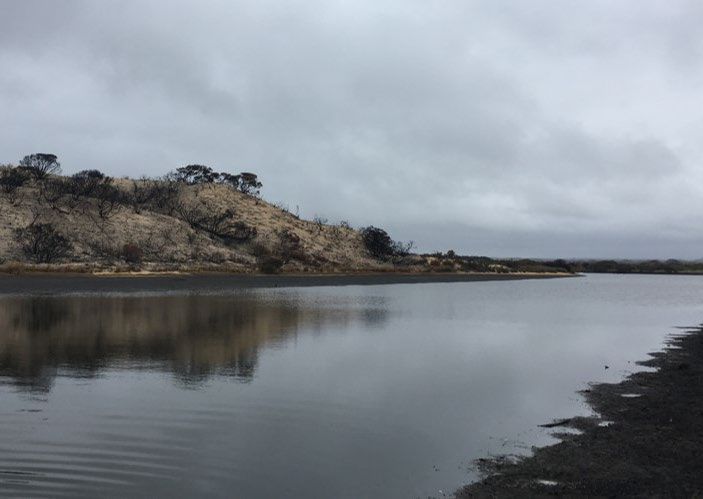
Cover: Lower estuary in Stun’Sail Boom and surrounding burnt dunes. Source:
Patrick Reis Santos
1
EFFECTS OF THE JANUARY 2020 BUSHFIRES ON ESTUARINE SYSTEMS OF KANGAROO ISLAND | REPORT NO. 603.2020

TABLE OF CONTENTS
ACKNOWLEDGMENTS                                                                                       4

INTRODUCTION                                                                                          5
Background                                                                                             5

UNDERTAKEN ACTIVITIES                                                                                 6
Post event data collection                                                                             6

FUTURE DIRECTIONS                                                                                     8
Ongoing work, research priorities and Expected outcomes                                                8

TEAM MEMBERS                                                                                           9

REFERENCES                                                                                            10

                                                                3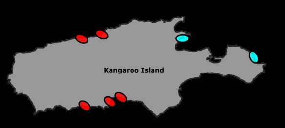
EFFECTS OF THE JANUARY 2020 BUSHFIRES ON ESTUARINE SYSTEMS OF KANGAROO ISLAND | REPORT NO. 603.2020

ACKNOWLEDGMENTS
Travel related expenses for field collections in Kangaroo Island were funded
through the Bushfire and Natural Hazards CRC Quick Response Fund.

                                                                4
EFFECTS OF THE JANUARY 2020 BUSHFIRES ON ESTUARINE SYSTEMS OF KANGAROO ISLAND | REPORT NO. 603.2020
INTRODUCTION
BACKGROUND
The 2020 summer bushfires on Kangaroo Island were the largest in the Island’s recorded history, with
over 200,000 hectares and more than 40 % of the island burnt (DEW, 2020). The impacts of these
bushfires will not be confined to the terrestrial landscape and are likely to have substantial
detrimental impacts on the island’s aquatic systems, particularly after rainfall.
Post-fire exposed soils are highly erodible, and therefore intense precipitation events or seasonal
rainfall can result in the runoff of nutrients and ash enriched sediments, debris and other products
of combustion into waterways. These runoff events, allied to heavy sedimentation, can lead to
deteriorating water quality, potentially triggering eutrophication, low oxygen events, and
compromise aquatic fauna. In addition, contaminants, including trace elements and products of
combustion such as polycyclic aromatic hydrocarbons (PAHs) can also enter waterways (Olivella
et al 2006, Shakesby and Doerr, 2006, Smith et al 2011, Sequeira et al 2020).
One area of concern in Kangaroo Island are the estuarine systems downstream or adjacent to
burnt areas. Despite the ecological importance of estuarine environments and the multiple
ecosystem functions they provide (including nursery grounds for juvenile fish), the impacts of
bushfires in estuaries are yet to be investigated. Furthermore, because estuarine systems in
Kangaroo island are not permanently open to the sea, the impacts of accumulated soot, ash and
sediment channelled into estuaries could be exacerbated, and have the potential to disrupt
complex ecological and biogeochemical cycles, increase contaminant loadings and result in
pervasive effects for local fish communities. Ultimately, there are substantial knowledge gaps in our
understanding of water quality impacts and mobilisation of heavy metals and isotopes in the
aftermath of bushfires in estuaries, and these add to the lack of understanding of the ecology and
geochemistry of estuaries in South Australia.
In this context, the Bushfire and Natural Hazards CRC, via the Quick Response Fund, provided
financial support for travel-related expenses to undertake surveys on Kangaroo Island in estuaries
within areas directly affected by this unprecedented bushfire season, and control sites outside
these areas. These sampling events are part of broader research where in the long term, we aim
to evaluate the impacts of bushfires on estuarine water quality and on estuarine fish, as well as
trace the mobilisation and fluxes of contaminants released by bushfires into estuarine systems.
5EFFECTS OF THE JANUARY 2020 BUSHFIRES ON ESTUARINE SYSTEMS OF KANGAROO ISLAND | REPORT NO. 603.2020
UNDERTAKEN ACTIVITIES
POST EVENT DATA COLLECTION
Water and fish sampling
In late April and May 2020, we travelled to Kangaroo Island to collect water and fish in the Cygnet,
Middle, Western, Stun’Sail Boom, Harriet, Eleanor and Chapman estuaries (Figure 1). Sampling
targeted estuaries that were directly affected by bushfires (i.e. surrounding areas and catchments
burnt), as well as estuaries where there were no direct fire impacts on the estuary but parts of their
catchment were burnt (Cygnet), and estuaries where there were no direct impacts on the
catchment (Chapman) (Figure 1, 2).
FIGURE 1 – MAP OF SAMPLED ESTUARIES ON KANGAROO ISLAND. IN RED, ESTUARIES AFFECTED BY THE SUMMER 2020 BUSHFIRES
ON THE ISLAND, IN BLUE, ESTUARIES IN AREAS NOT DIRECTLY AFFECTED BY THE SUMMER BUSHFIRES.
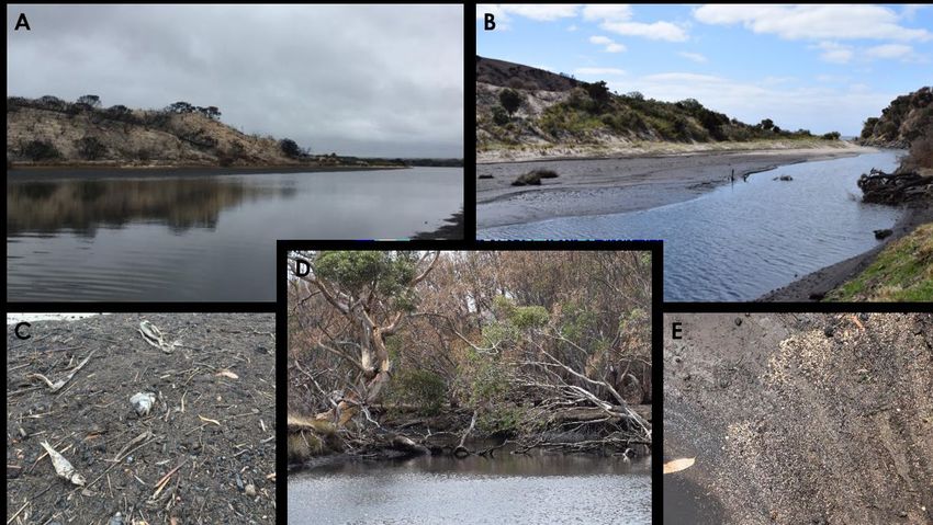
FIGURE 2 – ESTUARIES AFFECTED BY BUSHFIRES. A) LOWER ESTUARY STUN’SAIL BOOM AND SURROUNDING BURNT AREAS, B)
MOUTH OF THE WESTERN ESTUARY WITH HEAVY SEDIMENTATION C) EVIDENCE OF FISH KILLS IN THE HARRIET ESTUARY, D) BURNT
VEGETATION SURROUNDING THE UPPER MIDDLE ESTUARY, AND E) ASH AND FIRE DERIVED SEDIMENTS IN MIDDLE RIVER.
6EFFECTS OF THE JANUARY 2020 BUSHFIRES ON ESTUARINE SYSTEMS OF KANGAROO ISLAND | REPORT NO. 603.2020
We sampled two sites per estuary (though this was not possible in some cases due to access
limitations). At each site, we measured a set of physicochemical parameters, including
temperature, salinity, dissolved oxygen, and pH using a multiparameter probe. For quantification
of the concentrations of dissolved nutrients (e.g. ammonia nitrogen, oxides of nitrogen, filterable
reactive phosphorus) and dissolved organic carbon (DOC) waters were collected and
immediately filtered through a 0.22µm filter. Unfiltered water samples were also collected for
measurements of total nutrient concentrations (total nitrogen, total phosphorus). Larger volumes
of water (1L) were collected for estimates of total suspended solids and particulate organic
carbon, as well as for contaminant, metal and isotope analysis (e.g. Mn, δ87Sr, PAH).
To evaluate estuarine fish communities, we used a small hand-held seine net to collect fish (at the
same sites of water collections). Three replicate short hauls were made per site to assess fish species
composition, abundance, and potential variations in functional diversity.
Preliminary findings
Travel-related expenses supported by the Bushfire and Natural Hazards CRC Quick Response fund,
were essential for this sampling to take place. Data will be compared in the long term with sampling
that has been previously undertaken by us, as well as other collections we aim to perform later in
the year. Nutrient, element, and isotopic analyses from these sampling times are ongoing, affected
by COVID-19 related delays, and pending the start of an associated Coastal Research &
Development Grant from the Department for Environment and Water (DEW), South Australia that
will covers analytical costs.
Preliminary findings of field-collected data show variation in physicochemical properties and
nutrients, with data indicative of potential eutrophication, with nutrient enrichment, and low
dissolved oxygen in several estuarine sites. Whilst dissolved oxygen concentrations were between
95 and 101 % for the Chapman estuary (our control site), the remaining sites had lower dissolved
oxygen, with a minimum of 27.4% at Stun’Sail Boom. Total nitrogen (µgN/L) was highest for Stun’Sail
Boom at both sampling times (2400 & 2000 µgN/L) with overall values for the remaining estuaries
varying between 395 µgN/L (Harriet) and 1400 µgN/L (Middle). For total phosphorus, the highest
values were found at the upper Middle river (110 µgP/L) followed by Stun’sail Boom 79 (µgP/L).
A range of post-fire conditions, including heavy sedimentation, turbidity and poor water quality will
likely compromise survival and fish abundance in estuaries. We documented fish mortality, with
evidence of fish kill events noticeable along the shores of a few of the sampled sites (e.g. Middle,
Harriet, Stun’Sail Boom) (Figure 2). Fish were present in all estuaries, but there was low diversity
(maximum 3 species). Overall, the main species present were smallmouth hardyheads
Atherinosoma microstoma and black bream Acanthopagrus butcheri. One of the most interesting
findings was the collection of numerous age 0+ individuals of black bream, including in the areas
of Stun’Sail Boom where the lowest oxygen measurements were observed. Whilst larger juvenile
and adult black bream were found in several estuaries (e.g. Harriet, Middle, Chapman), the
assemblages were dominated by smallmouth hardyheads, especially in the lower Eleanor and
Chapman estuaries.
7EFFECTS OF THE JANUARY 2020 BUSHFIRES ON ESTUARINE SYSTEMS OF KANGAROO ISLAND | REPORT NO. 603.2020
FUTURE DIRECTIONS
ONGOING WORK, RESEARCH PRIORITIES AND EXPECTED OUTCOMES
This is a unique opportunity to gain valuable data documenting recovery following bushfires.
Recurring sampling will be essential to assess changes over time, and therefore characterise the
short and longer-term impacts of the summer bushfires on the estuarine systems of Kangaroo Island.
In particular, to understand how nutrients, metals and toxins from the combustion of organic matter
affect estuarine systems, as well as quantify their local fluxes using isotope tracers, and constrain
their sources and bio-geochemical pathways, additional analyses will be undertaken.
We have previously collected water samples and other water quality data post-fire but before
significant rainfall, and immediately after rainfall. Further sampling is also expected, supported by
a Coastal Research & Development Grant from the Department for Environment and Water (DEW),
South Australia, which also covers analytical costs. All data on water quality and fish assemblages
can also be compared to historical data.
Fire severity varied throughout Kangaroo island, and the areas surrounding the multiple estuaries
on the island and their respective catchments have been differently affected (DEW, 2020). At
present, there is no information on the spatial and temporal scale of these impacts or how they
may relate to fire intensity and other catchment scale variables (e.g. percentage of catchment
burnt). We will strive to relate our results on water quality, metal and isotopic variations, and
variations in fish communities to burn severity in each catchment.
Fish were collected in both sampling events. This suggests that individuals found refugia, or coastal
individuals are re-settling or opportunistically using the estuaries following the opening of the
estuarine entrances. This warrants further research, allied to understanding if the levels of persistent
compounds or contaminants (heavy metals, PAHs) entering the estuaries due to the bushfires pose
any deleterious risks to the fish community or jeopardise estuarine nursery function. Greater
knowledge on post-fire impacts to variations in concentrations of contaminants will also be
relevant concerning the consumption of local biota.
8EFFECTS OF THE JANUARY 2020 BUSHFIRES ON ESTUARINE SYSTEMS OF KANGAROO ISLAND | REPORT NO. 603.2020
TEAM MEMBERS
This project was coordinated by Professor Bronwyn Gillanders and Dr Patrick Reis Santos. Field
surveys were completed by Dr Patrick Reis Santos, Dr Judith Giraldo and Mr Koster Sarakinis.
9EFFECTS OF THE JANUARY 2020 BUSHFIRES ON ESTUARINE SYSTEMS OF KANGAROO ISLAND | REPORT NO. 603.2020
REFERENCES
DEW, Department for Water and Environment, National Parks & Wildlife Service, South Australia (2020).
Kangaroo Island Bushfire 2019-20, website and online arc gis application, https://arcg.is/0zSeWK, accessed
July 2020.
Olivella MA, Ribalta TG, De Febrer AR, Mollet JM, De Las Heras FXC (2006). Distribution of polycyclic aromatic
hydrocarbons in riverine waters after Mediterranean forest fires. Science of the Total Environment 355 156-
166.
Sequeira MD, Castilho AM, Tavares AO, Dinis P (2020). Assessment of superficial water quality of small catchment
basins affected by Portuguese rural fires of 2017. Ecological Indicators 111 105961.
Shakesby RA, Doerr SH (2005). Wildfire as a hydrological and geomorphological agent. Earth-Science Reviews
74 269-307.
Smith HG, Sheridan GJ, Lane PN, Nyman P, Haydon S (2011). Wildfire effects on water quality in forest
catchments: a review with implications for water supply. Journal of Hydrology 396 170-192.
Wallbrink P, English P, Chafer C, Humphreys G, Shakesby R, Blake W, Doerr S (2004). Impacts On Water Quality
By Sediments and Nutrients Released During Extreme Bushfires: Report 1: A Review of the Literature
Pertaining to The Effect of Fire On Erosion And Erosion Rates, With Emphasis on The Nattai Catchment, NSW,
Following the 2001 Bushfires. CSIRO and Sydney Catchment Authority Collaborative Research Project.
10You can also read