Regulation of the flood in October
 2009 at the Srisailam project in
               India
←
→
Page content transcription
If your browser does not render page correctly, please read the page content below
Regulation of the flood in October
2009 at the Srisailam project in
India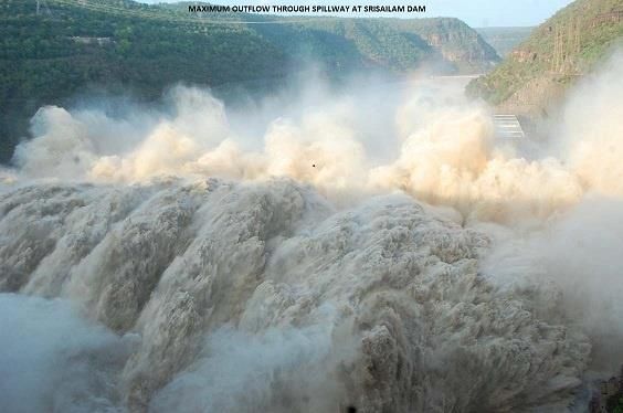
Introduction
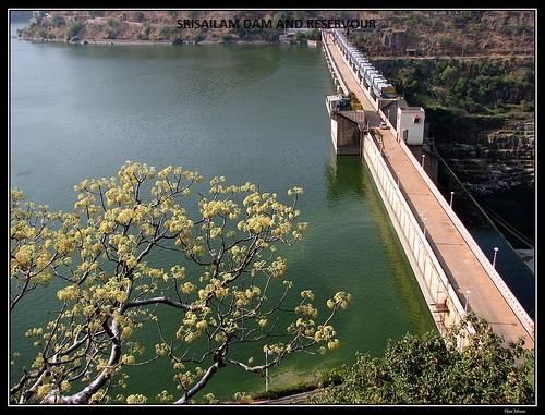
• Name of Dam : NSRS Srisailam Project
• Year of Completion : 1984
• River / Basin : Krishna in Peninsular India
• Nearest city : Hyderabad
• Type : Gravity/Concrete
• Height above lowest foundation : 475 feet (145 m)
• Length of Dam : 1680 feet (512 m)
• Top level of dam : + 904 feet (275.539m)
• MWL : +892.00 feet (271.881 m)
• FRL : + 885.00 feet (269.748 m)
• MDDL for irrigation : 854 feet (260.299 m)
• Sill level of the RC gates : 830 feet (252.984 m)
• MDDL for Power : 798 feet (243.230 m)
• Volume content of Dam : 19,53,000 cum
• Reservoir area : 616.42 sqkm
• Purpose : multi-purpose hydel
• spillway capacity : 11,10,300 cusec (31,440
cumec) at FRL and 13.20 lakh
cusec (37,378 cumec) at MWL
• Dam design :for a thousand year return
flood of 20.20 lakh cusec
(57,200 cumec)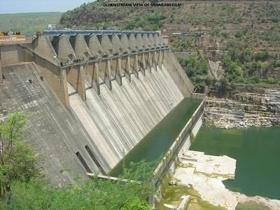
• installed capacity             : 1670 MW
• two powerhouses:
  left bank powerhouse            : 900 MW (6 X 150MW)
  right bank powerhouse           : 770 MW (7 X 110 MW)
• reservoir capacity at FRL       : 263.63 TMC(7465 MCM)
• spillway vents                  : 12 nos. of 60 feet x 55
                                  feet(18.288m x 16.764m)
                                  with radial crest gates
• restriction imposed that the end gates of no.1 and no.12
  be operated during extreme floods only.
• magnitude of the present flood : 25.50 lakh cusec
                                         (72,207 cumec)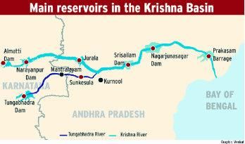
• unprecedented rainfall received during September 29th
  to 2nd October, 2009.
• rainfall ranged from 344mm to 560 mm.
• bulk of rainfall occurred below the major storage
  reservoirs of upper riparian States without giving any
  scope for flood moderation.
• unprecedented floods occurred between 2.10.2009 to
  6.10.2009 and inflow of 25.50 lakh cusec (72,207
  cumec) on 2.10.2009 occurred.
• earlier recorded highest flow of 10.60 lakh cusec (30,015
  cumec) occurred on 7.10.1903.
• design flood of the dam is 19.55 lakh cusec (55,359
  cumec).
• max water level recorded: + 896.50 feet (273.253 m)
• max discharge through spillway: 14, 80,400 cusec
                                     (41,920 cumec)
• duration of high flood           : nearly 78 hours
• end gates in vents 1 and 12 were also opened
• successful routing of more than 600 TMC (16,990 MCM)
  of flood over 600 kilometers of river length.
• earlier, high floods had occurred during 1998 and right
  side powerhouse inundated under the tail water of the
  dam due to opening of 12th gate.
• sudden surge in inflows was a result of record rainfall in
  the un-intercepted catchment area downstream of
  Tungabhadra dam and Jurala project but upstream of
  Srisailam dam.
• as the run off was in the area not covered by the gauging stations, the magnitude of the inflows received could not be anticipated well in advance. • as a result, pre depletion of the reservoir was not possible to such an extent that the upstream water levels could be limited to +892.00 feet (271.881m). • however, the reservoir level was brought down from + 884.90 feet (269.717 m) at 19.00 hrs on 30.09.09 to a level of +880.60 feet (268.406 m) by 23.00 hrs on 01.10.2009, depleting to an extent of 27.289 TMC (771.738 MCM)
Filling up of the reservoir
• after the floods of 1998, the Committee set up by the
  Government went into the issue of the date by which the
  Srisailam reservoir could be filled up to FRL.
• it noted that, the reservoir being utilized for power
  generation, it would be advantageous to build up higher
  levels as soon as possible and that it could be used for
  moderation only when extreme floods warrant it.
• Srisailam reservoir is being used for conservation while
  the Nagarjunasagar (NSP) reservoir (about 100km
  downstream of Srisailam dam) for moderation of the
  flood.
• from the past experience it could be seen that if the
  reservoir is not filled up to the FRL even by September
  15th, the success rate of the utilizations for power
  generation and irrigation needs would be coming down.
• after the floods in 1998, exercises were carried out to
  determine the extent of pre depletion required to limit the
  reservoir level to the MWL, in case of occurrence of the
  design flood of 19,55,000 cusec (55,359 cumec).
• exercises indicated that even with advance forecasts,
  the MWL cannot be limited to + 892.00 feet (271.881 m)
  because of the spillway constraints (operation of end
  gates) and the period of advance notice that would be
  available being less than 24 hours.
• this has now been proved correct.
• exercises carried out earlier had pin pointed the need to
  put in place an effective advance flood warning
  mechanism.
• though the flood intensity downstream of the two
  upstream projects- Jurala and Sunkesula could be
  known in advance, there is no arrangement to monitor
  and obtain the inflow data from the intermediate
  catchment. It is, therefore necessary that gauges are set
  up in this area to obtain real time data.
Flood monitoring
• water level in reservoir on 30.9.2009 at 6 AM was
  +884.40 feet (269.565 m)
• however keeping in view the flows observed at Jurala
  Dam and in Tungabhadra river (Kurnool) and ongoing
  rainfall, spillway gates were operated from 7 PM on
  30.9.2009 with a discharge of 1,15,114 cusec (3259
  cumec) and further gradually increased to 5,34,650
  cusec (15,139 cumec)by 6 AM on 1.10.2009
• keeping in view of the increasing trend of flood on
  1.10.2009 morning, 10 gates were further raised to their
  total height with a discharge of 8,99,046 cusec (25,458
  cumec) including power draft.
• further the 11th gate (Gate No 12) was operated at 9 PM
  on 1.10.09 and discharge of 9, 66,052 cusec (27,355
  cumec) including power draft allowed.
• reservoir was depleted to +880.6 feet (268.406 m) by 11
  PM on 1.10.2009 from +884.90 feet (269.717 m) at 7 PM
  on 30.9.2009
• at MWL, the discharge from dam is 13.2 lakh cusec
  which is far below the peak inflow and it is the reason for
  built up of reservoir upto +896.50 feet, though all the
  gates were opened.
• by 9 PM on 1.10.2009, discharge of 4,50,000 cusec was
  observed at Kurnool gauge (Tungabhadra) and 11 out of
  12 gates were already opened at Srisailam.
• unprecedented high inflows started increasing the
  reservoir level and touched the FRL at 5 PM on
  2.10.2009.
• inflows in reservoir on 2nd October evening onwards
  were about 25.50 lakh cusec, which had resulted in
  impounding of flood water up to + 896.50 feet on
  3.10.2009 at 12.00 noon.
• at 11 30 am on October 3, vibrations were observed at
  the level of the road deck and hoist bridge when the
  upstream water levels were in the order of +896.00 feet
  and above.
• Gate No 1 and other gates were lifted further by 6 feet
  i.e., 55 feet above sill level and facilitated the discharge
  to the tune of 14.5 lakh cusec
• after observing for one hour it was noticed that the water
  level in the reservoir did not rise and the water level at
  the bottom of T-Beam was reduced by 2 feet and that
  the vibrations in the civil structure and gate ropes were
  minimum.
• the ropes of Gate No 4 on right side were in snapped
  position and it was decided not to further operate this
  gate.
• engineers succeeded in opening the 12th gate of the
  dam (i.e., Gate No 1) at 1 pm on October 3 (after 20
  years) allowing 14.8 lakh cusec outflow from the dam.

    Post flood status of the dam
• dam did not suffer any major structural damage.
• operation of the end gates resulted in significant
  erosions to both the right and left flanks.
Spillway and non over flow • dam withstood the unprecedented floods. • bearings of the road bridge were intact and no displacement or damage was apparent. • dam had tilted by 4mm on October 3. • tilt reached a maximum of 8.8 mm on October 8. • each square metre of the dam had to withstand the uplift pressure of over 170 tonnes while the permitted level is only 143 tonnes.
Gates
• there were problems in proper functioning of the turn
  buckles, noise in the gear worms, loosening and
  entangling of wire ropes etc.

                     Plunge Pool
• deep scours could have taken place in plunge pool,
• exact nature of changes that have taken place have to
  be first known.
• bottlenecks in carrying out any work downstream are:
  limited time available for works, extreme difficult terrain
  in gaining access to the work area, considerable depth of
  water and finally the exorbitant cost of such works.
• bed contours of the downstream area are plotted after taking levels by soundings and super imposed over the last year’s contours to know the changes. • need for any immediate or long term measures is being assessed Erosion of the right and left bank hill slopes • operation of the end gates has resulted in significant erosions to both the right and left flanks. • this is not an unexpected feature, as these have been anticipated and confirmed through model studies earlier. It is for the same reason that restrictions were placed on opening the end gates in vents 1 and 12. • the gate in vent no 1 though opened had discharged only the spilled water over the stop log gates.
• erosion took place mainly on account of the flare of the
  ski jump jet due to flow in vent no 2. Similar is the case
  with the vent 12.
                         Left flank
• left flank hill slope has attained a near vertical slope
  above the water surface;
• profile below the water surface is to be verified after the
  downstream water levels go down.
                        Right flank
• three cavities were formed on the right bank as a result
  of the impingement of the ski jump jet on the flank.
• these are located at about 1000 feet downstream of the
  reference line and are at an elevation of about +610.00
  feet.
• inter bedded sequence of quartzite and shale is exposed downstream of the bucket between vent 12 and the upstream of the right bank power house. • sedimentary sequence is intersected by two sets of moderately close to widely spaced joints and near horizontal bedding planes. • on account of the opening of gate 12, huge blocks of shale and quartzite forming the right bank was removed damaging the road leading to the river bed. • flare of the water jet beyond the bucket resulted in the removal of thinly bedded shale/quartzite sequence resulting in the formation of cavities on the right bank. • these pockets located away from the dam and pose no risk to the dam and will not have any impact on the stability of the dam.
• the sizes of openings are not of such nature as to bring
  down the overburden. Back filling with any material
  would also not be effective.
• as the recurrence of similar flood is unlikely in the near
  future, it is necessary to keep a watch on the cavities
  and consider any remedial measures after observance
  over occurrence of 2 or 3 normal floods.
• the ledge at elevation of +600.00 feet and below has the
  possibility of further erosion in the future floods, as the
  area is opposite to vents 10 and 11. This is also just
  upstream of the power house structure.
• the CWC has earlier recommended anchors,
  underpinning the over hangs with concrete and also
  laying concrete in suitable steps as a remedial measure.
Studies and surveys to be
             carried out
• to assess the extent of erosion of the plunge pool area
• identifying the probable locations for installation of rain
  gauges in the catchment area upstream of Srisailam
  dam but but downstream of Jurala and Sunkesula
  projects,
• review record of vibrations during the flood period (from
  30.09.2009 to 06.10.2009) and also from the strong
  motion accelerographs erected in blocks 12 and 18,
• stability analysis of spillway section and non overflow
  section for the conditions obtained during the floods and
  comparing them with the design assumptions,
• seepage studies covering the same period and compare
  the uplift pressures recorded with that of the design
  parameters,
• assess the status of the drainage holes, Review of all
  other instrumentation data during the flood period,
• hydrographic surveys to assess the extent of loss of storage after the floods, • flood routing studies with different pre depletion levels of reservoirs at Srisailam and NSP for different flood magnitudes, • post flood detailed assessment by the Geological Survey of India of the geological features of both the hill slopes in the areas of anticipated ski jump jet areas. Short term works to be carried out • repairs to gates such as replacement of turn buckles, wire ropes, gear worms and other electrical items, • readying the zero bay area and shifting the stop log elements existing in vent no 1 to this bay, • acquisition of one new set of stop log elements, • acquisition of 60 T gantry crane, • rock bolting of the eroded area downstream of vents 10 to 12 on the right flank.
Long term works to be carried out
• 3-D model studies,
• protection works to the plunge pool to be identified and
  executed in stages,
• erection of automatic rain gauges in the catchment area
  downstream of Jurala and Sunkesula projects for real
  time data transfer to the site,
• evolving comprehensive guide lines for operation of
  Srisailam and NSP reservoirs for pre and post
  Pulichintala dam completion,
• assess the latest storage capacities of both the NSP and
  Srisailam reservoirs,
• conduct flood routing studies for both the reservoirs
  taking into account the restraints such as inoperative
  gates at Srisailam dam,
• limiting the upstream water levels to FRL only at
  Nagarjunasagar,
• the possibility of encroachment into free board at
  Srisailam dam, the limitation of channel capacity
  downstream of Prakasam barrage and evolve guide lines
  for operation of the reservoirs, to consider the scenario
  after the completion of the Pulichintala dam and evolve
  guide lines for the post Pulichintala dam completion
  period
   Srisailam right bank powerhouse and Srisailam left
    bank powerhouse had been affected due to floods
• Srisailam right bank powerhouse
• Precautionary measures taken:
  all seven units were stopped at 19:00 hrs on 02-10-2009
  to protect the powerhouse and personnel working in it.
  power Supply to the powerhouse was cut off anticipating
  entry of water and station made electrically dead.
water entered into the powerhouse from river side over the flood protection wall inundating it by 15:00 hrs on 03- 10-2009 as the tail water level rose to a peak of +646.2 feet above the flood protection wall constructed up to +640 feet. • Cost of restoration: draft tube gantry crane and gates - Rs 3.0 crore flood protection wall, approach road retaining wall, TRC structure, etc., - Rs 12.0 crore E& M equipment, panels etc,. - Rs 80.0 crore BHEL(Bharat Heavy Electricals Limited) services - Rs 10.0 crore rectification of Gen. Transformers - Rs 3.0 crore LT Boards, compressors, etc., - Rs 10.0 crore other miscellaneous works - Rs 1.35 crore total - Rs 119.35 crore
• Synchronization:
  1st unit by 05-12-2009.
  Balance 6 units by January 2010 at an interval of 10
  days.
• Left Bank Powerhouse
• Precautionary measures taken:
  All Six units were stopped at 19:00 hrs. on 02.10.2009.
  Entry point of inclined adit tunnel was plugged with
  cement concrete to prevent entry of water.
  The Crown Adit to powerhouse was plugged to avoid
  ingress of water into powerhouse.
  Thus major damages to the powerhouse were averted
  by providing concrete bunds at upstream and
  downstream sides of the river.
• Damages
 tail race surge cavern experienced heavy thrust of water
 and continuous splashing resulted in complete flooding
 of surge cavern.
 draft tube gates of six generating units damaged.
 civil structures of DG set and ventilation equipment
 building were damaged.
 approach road to the surge cavern was eroded severely.
• Cost of rectification:
  plugging of inclined adit and crown adit tunnels,
  clearing of boulders, construction of flood
  protection wall, strengthening of DG set building
  footings, etc                               - Rs. 3.5 crore.
  construction of flood protection wall and
  retaining wall; re-laying of approach roads- Rs.12.0 crore
  Rectification works of draft tube gates     - Rs. 3.5 crore
  Cost of new draft tube gates for 2 units - Rs. 1.0 crore
  Total                                       - Rs.20.0 crore
• Total cost of restoration of both the power houses
  Srisailam right bank powerhouse - Rs. 119.35 crore
  Srisailam left bank powerhouse - Rs. 20.00 crore
  Total                           - Rs. 139.35 crore
You can also read