Meteorological Mainstream: Hurricane Arthur
←
→
Page content transcription
If your browser does not render page correctly, please read the page content below
Meteorological Mainstream: Hurricane Arthur

Hurricane Arthur was an Independence Day spoiler for North Carolina merchants. It spun up off of the Florida coast as a
Tropical Depression on June 30 and strengthened into a hurricane July 3 as moved northward, taking a bead on the
North Carolina shore early on the morning of July 4. It was the earliest visit by a hurricane to the area since records
began in 1851.

      The eye of “Arthur” crossing Pamlico Sound, North Carolina early on the morning of July 4 / NWS radar data.

Hurricane Warnings had people running for high ground and leaving beaches deserted during a traditionally very
busy…and profitable…summer weekend. The storm reached Category 2 intensity with 100-mph winds as it paralleled
the coastline of the Tar-Heel State. There were trees and power lines downed and some roof and beach damage; Cape
Lookout weather equipment measured the highest wind gust at 101 mph. However, the sustained 100-mph winds
remained mostly offshore. Had Arthur’s track been just 40 miles farther west the story would have been much different,
and for the worse, not only due to winds but because of a considerable storm surge. As it was, the surge maxed out at
about four feet above normal. There was flooding, but it was far from catastrophic.

Arthur turned northeastward and headed out to sea quickly on the morning of July 4, allowing for some of the Holiday
weekend to be salvaged. Downed power lines and in some cases damaged roadways did hinder the flow of tourists but
it was not a total loss for area businesses.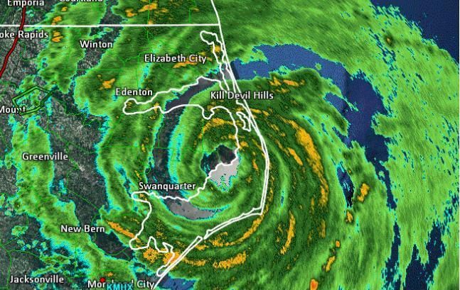
Coastal flooding along the Outer Banks: Unpleasant but not severe.
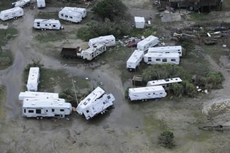
Recreational Vehicles damaged by Arthur’s winds / U.S. Coast Guard photos.
Arthur made a second landfall in southeastern Canada - Halifax, Nova Scotia measured gusts just under hurricane force
at 72 mph, and heavy rainfall brought inland flooding. Nova Scotia Power reported 135,000 customers in the dark at the
height of the storm.
Total insured losses for all affected areas in Canada and the United States were less than $250 million according to Risk
Management Solutions, which makes Arthur a pussycat as hurricanes go. The primary types of loss were wind damage
and coastal flooding along with a significant loss of business income on North Carolina’s busy vacation weekend. There
were no reported deaths associated with Arthur.
There have been no other tropical storms or hurricanes since Arthur, and overall the 2014 Atlantic season activity is
running a bit below average, this is consistent with our June discussion about the influence of El Nino on hurricanes.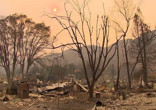
July Tornadoes in Virginia and New York
The huge Cherrystone campground in Cheriton, Virginia (near Norfolk) was filled with more than 1,000 overnighters
when it was pummeled by a rare morning tornado on July 24. Two campers died when a tree fell on their tent; thirty-
three other people were taken to area hospitals with varying degrees of injury. The tornado is being categorized as an
EF-1 (winds of 86 to 110 mph) by the National Weather Service. The same storm complex blew 18-wheelers off of the
highway and sank boats in a nearby harbor.
Campers destroyed by tornado as it kills 2, injures 33 in Virginia / WAVY-TV
This system was consistent with that of an expected stormy summer due to a persistent strong jet stream over the
eastern U.S. and southeastern Canada. For example, a mini-outbreak of tornadoes and severe thunderstorms on July 8
spanned several states from Ohio to New York, and killed four people in Smithfield, N.Y. in another unusual summer
tornado event. It was the second deadliest tornado in New York state history. Straight-line winds tore down trees and
power lines and left more than 200,000 people across Pennsylvania and New York in the dark after the storms passed.
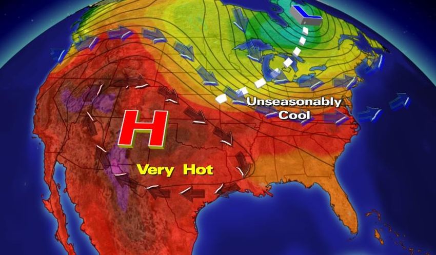
Hot Rockies, “Cool” East
A large upper high remained more or less anchored over the Rocky Mountain States for July with very hot temperatures
on tap, such as Denver’s 100 degrees on July 7th and Phoenix’s blistering 116 degrees (a record for the date) on July 24.
Meanwhile, areas from Texas to New York and into southern Canada experienced periods of below average
temperatures thanks to a strong flow from the north. Some called this “the polar vortex summer version”, and while not
technically correct, the cool temperatures were a fact.
A stagnant upper high and an unusually strong low over Canada kept cool air coming in July.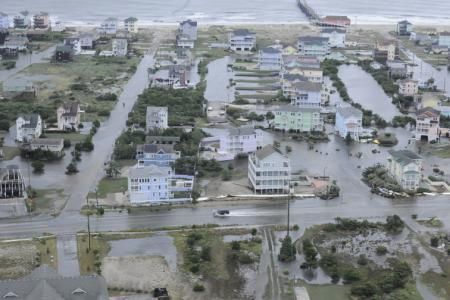
The odd weather pattern helped to produce extreme rainfall near the Dallas-Fort Worth Metroplex along a stationary
front; Valley View, Texas (60 miles northwest of Dallas) picked up 11 inches of rain in just three hours on July 17th! There
were 30 high-water rescues along Interstate 35, but luck was on the side of Texans because much of this rain fell in a
non-urban area, and there were no fatalities. Had the flood taken place in nearby Dallas or Fort Worth, the effects would
have been quite devastating - a similar flood that did hit Dallas in May 1995 left 20 dead and losses in the $100 million
range.

                    Waterlogged traffic on Interstate 35 / Photo: Jeff Smith / NBC5-TV Fort Worth, TX

Worst Wildfire in Washington State History

The western United States has been in a perpetual drought for several years, leaving forests ripe for wildfires. The
biggest fire ever recorded in Washington State began with a lightning strike on July 14. Several smaller fires merged into
a 28 square-mile (18,000 acre) beast on July 17 and this morphed into a mammoth 336 square-mile (215,000 acre)
inferno just 48 hours later. At press time the fire had grown to more than 250,000 acres, but it was about 60 percent
contained so the worst seems to be over.

Called the Carlton Complex fire, it has destroyed 153 homes in the north-central portion of the state, and one resident
died while fighting the fire near their home. The many cherry and apple orchards in the region managed to escape
significant damage. This fire eclipses the previous state record from way back in 1902. That fire, known as the Yacolt
Burn, charred 238,000 acres in the southwestern region of Washington.

It’s ironic that lightning can start big fires; one might think the flames would be quickly extinguished by the rain from the
storm. But storms can produce lightning with no rain at ground level when the precipitation evaporates into dry air
before it reaches the ground. This phenomenon, called virga, is common in the arid and mountainous west and
northward to the Canadian Prairie.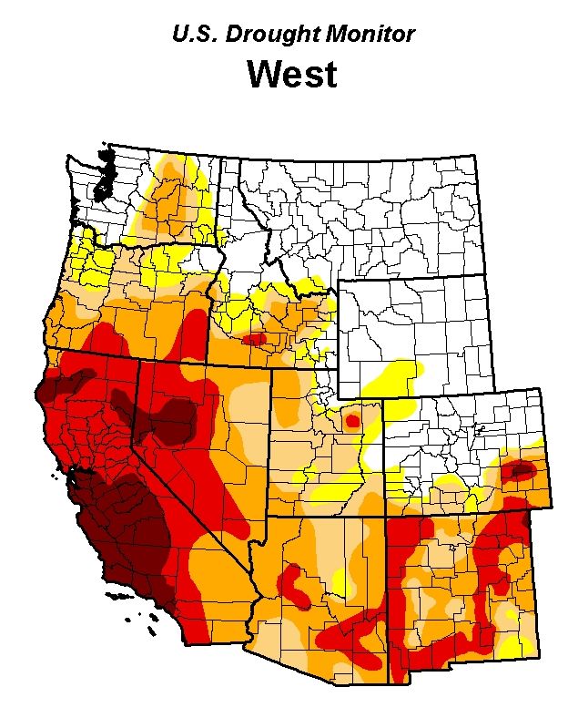
Some of the damage from the Carlton Complex Fire / KING-TV

Washington State is not the only place dealing with fires. The western United States in general has been in a multi-year
drought and with the primary fire season just getting started it could be a very long three months (August-October)
ahead. Take California, where many of their historic fires happen in the period June to October. The dryness is helped
along as we get into fall by the “Santa Ana” which blows down from the mountains with a hot, dry and gusty wind across
southern Californian areas like Los Angeles and San Diego.
Fire Outlook: California in the Hot Seat

Insurance losses from wildfires are expected to be at their worst in central and southern California, but extending
northward into Oregon and western Nevada through mid-autumn. This outlook takes into account the normally dry
pattern in late summer over the region coupled with the dryness already brought on by stingy skies during the winter
and spring, and the phenomenon of “dry lightning” storms with no rain (virga).

Los Angeles has received only three and a half inches of rain this year, just 38 percent of normal, San Diego is in a similar
situation with only 40 percent of normal rain year-to-date, and things aren’t any better in the mountains to the north, as
shown on this U.S. Drought Monitor map:

                              Weekly report issued July 24, 2014 / droughtmonitor.unl.edu

The darkest red color corresponds to the most severe drought category “Exceptional Drought”, which as you can see
covers much of southern and central California and even into northern portions of the state. The next-lighter shade is for
the extreme drought-affected areas.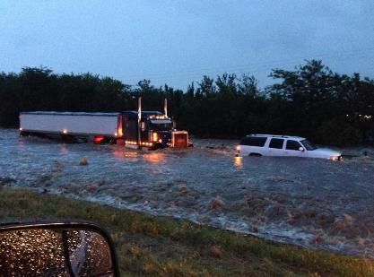
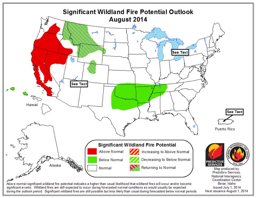
Here are the fire outlook charts as prepared by the National Interagency Fire Center:
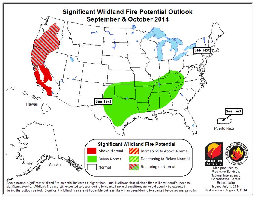
Note that above normal rainfall and the expected effect of El Nino call for improving fire conditions across the southern
Plains, but the Pacific states, especially California, may have a very tough late summer and fall fire season.

Keep an eye on the sky.
You can also read