Method for organic carbon stock assessment and improvement of Land Degradation Neutrality and climate change reporting on agricultural ecosystems ...
←
→
Page content transcription
If your browser does not render page correctly, please read the page content below
Method for organic carbon stock assessment
 and improvement of Land Degradation
Neutrality and climate change reporting on
 agricultural ecosystems in Kyrgyz Republic

 February 15, 2021

 CARB-ASIA MANUAL
CARB-ASIA MANUAL

This publication is part of the overarching GIZ (“Deutsche Gesellschaft für International
Zusammenarbeit” 1) program “Capacity Development for climate policy in the countries of South
East, Eastern Europe, the South Caucasus and Central Asia, Phase III”.

This project is part of the International Climate Initiative (IKI). The Federal Ministry for the
Environment, Nature Conservation and Nuclear Safety (BMU) supports this initiative on the basis
of a decision adopted by the German Bundestag.

About CARB-ASIA
CARB-ASIA is an interdisciplinary project of soil scientists and resource economists from Humboldt
University of Berlin as well as Kyrgyz universities, NGOs, and state authorities that jointly developed a
method to assess carbon stocks for different land-use types in Kyrgyz Republic. Based on a national survey
of the current state of soil carbon stocks, implications for sustainable land use are derived, which contribute
to the protection and increase of carbon stocks in the soils and improve climate monitoring and reporting
for agricultural ecosystems according to international standards.

Acknowledgements
This Handbook is the result of the joint efforts of many people who invested much of their experience,
enthusiasm, and work into its successful compilation. First and foremost, we greatly appreciate the financial
support of the “Deutsche Gesellschaft für Internationale Zusammenarbeit” (GIZ) and the Federal Ministry
for the Environment, Nature Conservation and Nuclear Safety (BMU) that funded the project under the
International Climate Initiative (IKI). Furthermore, we are particularly indebted to our collaborators and
supporters in Kyrgyz Republic, among others, the political representatives of the Kyrgyz Ministry of
Agriculture, Food Industry and Melioration (the National Focal Point of UNCCD), the National Statistical
Committee, and the State Agency for Environmental Protection and Forestry. Our special thanks go to
academic colleagues from the American University of Central Asia, the National Academy of Science,
Kyrgyz National Agrarian University, and the Kyrgyz Research Institute of Agriculture. In this context, we
wish to express our special gratitude to colleagues from the Kyrgyz Soil Science Society who shared the
efforts of organizing and conducting the work. Moreover, gratitude is owed to the advisors and consultants
from the national and international organizations, such as GIZ, FAO, ICRAF, World Bank, and UNCCD.

Authors: Margarete Korintenberg, Anastasia Gotgelf, Ermek Baibagyshov, Renate Judis, Ulan
Kasymov, Judith Walter, Stephan Lange, Paul Neetzow, Klaus Eisenack, Jutta Zeitz

This manual can be cited as follows:
M. Korintenberg, A. Gotgelf, E. Baibagyshov, R. Judis, U. Kasymov, J. Walter, S. Lange, P. Neetzow, K. Eisenack, J. Zeitz (2021):
Method for organic carbon stock assessment and improvement of Land Degradation Neutrality and climate change reporting on
agricultural ecosystems in Kyrgyz Republic, Soil Science and Resource Economics Group, Humboldt-Universität zu Berlin,
Germany.

1
 As a federally owned enterprise, GIZ supports the German Government in achieving its objectives in the field of
international cooperation for sustainable development.

 2
CARB-ASIA MANUAL

Table of Contents
List of Figures ............................................................................................................................................... 5
List of Tables ................................................................................................................................................. 6
Abbreviations ................................................................................................................................................ 7
Executive Summary ...................................................................................................................................... 9
Chapter 1. Introduction.................................................................................................................................11
 1.1 CARB-ASIA Project and main objectives .........................................................................................11
Chapter 2. Background ................................................................................................................................ 12
 2.1 Land Degradation Neutrality (LDN)................................................................................................. 12
 2.1.1 The goal and objectives of LDN................................................................................................. 12
 2.1.2 Assessing LDN ........................................................................................................................... 13
 2.2 LDN in Kyrgyz Republic .................................................................................................................. 15
 2.2.1 National data for land cover indicator development .................................................................. 16
 2.2.2 National data for land productivity indicator development ........................................................ 16
 2.2.3 National data for soil organic carbon indicator development ..................................................... 17
 2.3 Indicator Soil Organic Carbon (SOC) ............................................................................................... 19
Chapter 3. Method for soil organic carbon stock recording in Kyrgyz Republic ....................................... 25
 3.1 Identification of representative units................................................................................................. 26
 3.2 Field methods .................................................................................................................................... 31
 3.3 Laboratory methods .......................................................................................................................... 34
 3.4 Calculation of parameters ................................................................................................................. 35
 3.5 Validating the method – selected results of statistical analysis ......................................................... 36
 3.6 Use of the baseline for reporting on soil organic carbon stock changes ........................................... 43
Chapter 4. Institutional framework for assessment, monitoring, and reporting on soil organic carbon stock
..................................................................................................................................................................... 46
 4.1 Existing institutional environment and modes of ecological data provision and exchange in Kyrgyz
 Republic .................................................................................................................................................. 46
 4.1.1 Current developments relevant for LDN monitoring and reporting ........................................... 47
 4.1.2 Constraints, gaps, and related capacity needs............................................................................. 51
 4.2 Proposals to formalize the developed method and improve national capacity to meet LDN reporting
 obligations ............................................................................................................................................... 55
 4.2.1 The importance of formalizing the new method ........................................................................ 55
 4.2.2 Recommendations towards capacity development ..................................................................... 56
Chapter 5. Conclusions and outlook............................................................................................................ 66

 3
CARB-ASIA MANUAL

 5.2 Limitations of research...................................................................................................................... 67
 5.3 Transferability of project results ....................................................................................................... 67
References ................................................................................................................................................... 68
Appendix ..................................................................................................................................................... 74
 A. Profile recording sheet ....................................................................................................................... 74
 B. Formulae for calculating the individual parameters ........................................................................... 76
 C. Influential factor clay ......................................................................................................................... 80
 D. Small-scale variability........................................................................................................................ 80
 F. Different individual parameters and their relationship to each other .................................................. 82

 4
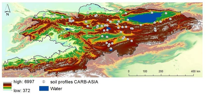
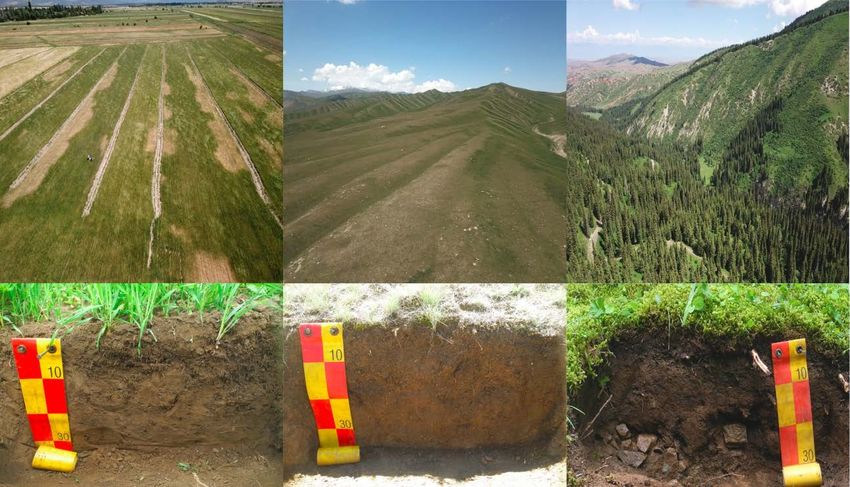
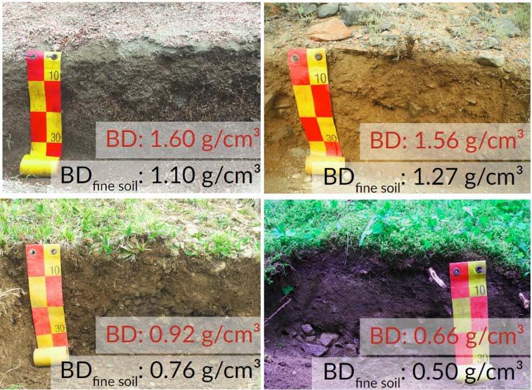
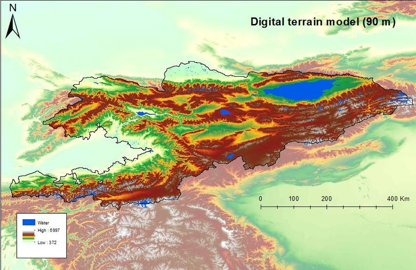
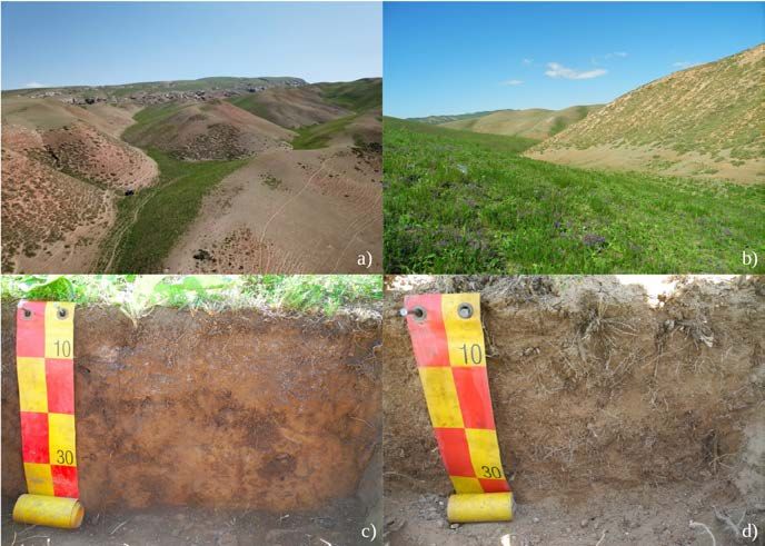
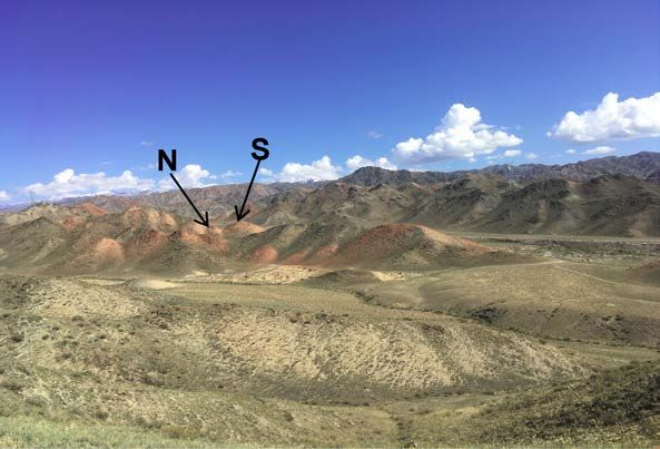
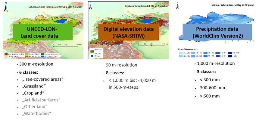
CARB-ASIA MANUAL

List of Figures
Figure 1: Kyrgyz grassland location with a densely vegetated northern slope and sparse vegetation on the
southern slope and their profiles ................................................................................................................. 22
Figure 2: High coarse soil content in Kyrgyz soils ..................................................................................... 23
Figure 3: Comparison of bulk density and bulk density of the fine soil in Kyrgyz soils ............................ 23
Figure 4: Main classes of land cover in Kyrgyz Republic at 300 m resolution........................................... 26
Figure 5: Digital elevation model in 90 m resolution.................................................................................. 27
Figure 6: Mean annual precipitation (mm) in Kyrgyz Republic ................................................................. 28
Figure 7: Sampling point on a plain grassland site...................................................................................... 31
Figure 8: Sampling points on the north and south slopes on a hilly grassland site ..................................... 31
Figure 9: Soil pits in different land-cover classes: cropland, grassland, tree-covered area ......................... 32
Figure 10: Sampling design ......................................................................................................................... 32
Figure 11: Organic carbon stocks of the representative units...................................................................... 36
Figure 12: Relationship between land cover and soil organic carbon stocks .............................................. 38
Figure 13: Relationship between elevation class and soil organic carbon stocks ....................................... 38
Figure 14: Relationship between precipitation class and soil organic carbon stocks .................................. 39
Figure 15: Relationship of soil organic carbon content [%] and bulk density of the fine soil [g/cm3] ....... 40
Figure 16: Comparison of organic carbon content as a percentage and organic carbon stocks in tonnes per
hectare of the representative units ............................................................................................................... 41
Figure 17: Current management of environmental data and information in Kyrgyz Republic ................... 50
Figure 18: Soil profiles of the CARB-ASIA project ................................................................................... 74
Figure 19: Use of an Edelmann drill ........................................................................................................... 75
Figure 20: Core rings for the determination of the bulk density of the fine soil ......................................... 75
Figure 21: Relationship between percentage clay content and soil organic carbon stocks in tonnes per hectare
for grassland sites ........................................................................................................................................ 80
Figure 22: Relationship between exposition and soil organic carbon stock in tonnes per hectare for the land-
cover class grassland ................................................................................................................................... 80
Figure 23: Small-scale variability of the percentage of organic carbon content of the sampling points..... 81
Figure 24: Relationships of the individual parameters to each other with specification of the correlation
coefficient according to Spearman (rsp) and the probability measure (p) .................................................... 82

 5
CARB-ASIA MANUAL

List of Tables
Table 1: Classes of the three influential factors........................................................................................... 28
Table 2: Representative units....................................................................................................................... 29
Table 3: Procedure for the determination of coarse soil and bulk density of the fine soil during field sampling
..................................................................................................................................................................... 33
Table 4: Overview of laboratory parameters, methods, and number of samples ........................................ 35
Table 5: Distribution of parameters within representative units.................................................................. 37
Table 6: Land use factors (FLUs) for selected examples of changes in land cover .................................... 44
Table 7: Implications for change - Technical infrastructure, data, and format layer ................................... 59
Table 8: Development of the LDN framework in Kyrgyz Republic ........................................................... 63
Table 9: Implications for change - Organizational layer ............................................................................. 64
Table 10: Profile record sheet used for CARB-ASIA ................................................................................. 75
Table 11: Humus factor for correction in the transfer function ................................................................... 76

 6
CARB-ASIA MANUAL

Abbreviations
ARIS Kyrgyz Republic´s Community Development and Investment Agency
BD Bulk Density
BDfine soil Bulk Density of the Fine Soil
CAREC Regional Environmental Centre for Central Asia
CBD Convention on Biological Diversity
CO2 Carbon dioxide
CH4 Methane
DADO District Agrarian Development Offices
EVI Enhanced Vegetation Index
FAO Food and Agriculture Organization
FI Input Factor
FLU Land Use Factor
FMI Forest Management Inventory
GEF Global Environment Facility
GHG Greenhouse gas
GIS Geographical Information System
GIZ Deutsche Gesellschaft für International Zusammenarbeit
GAFA Expert Committee Forest Analysis
IPCC International Panel on Climate Change
KA5 German Soil Science Mapping Guide – „Deutsche Bodenkundliche
 Kartieranleitung”
KNAU Kyrgyz National Agrarian University
Kyrgyzgiprozem Kyrgyz State Design Institute of Land Management
LDN Land Degradation Neutrality
LMG Management Factor
MAFIM Ministry of Agriculture, Food Industry and Melioration of the Kyrgyz Republic
MRV Monitoring Reporting Verification
NDVI Normalized Difference Vegetation Index
NFI National Forest Inventory
NGO Non-governmental organization
NSC National Statistical Committee of the Kyrgyz Republic
PUC Pasture User Committee
RPAS Republican Soil Agrochemical Station

 7
CARB-ASIA MANUAL

SAEPF State Agency of Environmental Protection and Forestry under the Government of
 the Kyrgyz Republic
SALR State Agency for Land Resources
SDGs Sustainable Development Goals
SOC Soil Organic Carbon
SOCStocks Soil Organic Carbon Stocks
STAP Scientific and Technical Advisory Panel
UN United Nations
UNCCD United Nations Convention to Combat Desertification
UNFCCC United Nations Framework Convention on Climate Change
UNDP United Nations Development Programme
UNEP United Nations Environmental Programme
UNECE United Nations Economic Commission for Europe
WB World Bank

 8
CARB-ASIA MANUAL

Executive Summary
In 2016, the United Nations (UN) adopted the Sustainable Development Goals (SDGs) with 169 sub-goals.
Sub-goal 15.3 aims for a "Land Degradation Neutral" (LDN) world by 2030, to be achieved through national
efforts of the UN member states. Since 2018, countries supporting LDN have been requested to report to
the UN on the state and change of state of three globally recognized indicators: land use, land productivity
(recorded as net primary production), and soil organic carbon stocks (SOCstocks) within their national borders.
Accordingly, land degradation is neutral when all indicators show at least no deterioration of their status.
Reporting can be done using the global dataset provided by the Secretariat of the United Nations Convention
to Combat Desertification (UNCCD) (Tier 1), although the UNCCD recommends that indicators shall be
compiled based on national data (Tier 2 and Tier 3). Previous experience from various countries shows that
the use of global datasets sometimes leads to inaccuracies. However, there is a lack of national data
available, especially for the indicator SOCstock. The SOCstock indirectly provides information on the humus
content of soils and is thus an indicator of soil health. It is also highly relevant to climate change since a
loss of soil carbon releases greenhouse gases into the atmosphere and accelerates global warming.
In 2017, Kyrgyz Republic declared its participation in the national measuring of LDN. The first LDN report,
prepared by the national LDN working group in 2018, identified serious gaps in national carbon stock data
and provided recommendations for the development of LDN assessment and monitoring. The German-
Kyrgyz project "Development of Methods for the Assessment of Carbon Reservoirs and for the
Improvement of Climate Reporting of Agricultural Ecosystems of Central Asia" (CARB-ASIA) builds on
previous work of the LDN working group and aims to develop and test the applicability of an improved
method for assessing SOCstocks in Kyrgyz Republic and to propose ways to institutionalize such an
assessment tailored to the possibilities in Kyrgyz Republic.
The results of this project have been discussed in various forms (e.g. during interviews and expert
consultations, workshops and online discussions) with representatives of government institutions (the
Kyrgyz Ministry of Agriculture, Food Industry and Melioration; the National Statistical Committee; State
Agency for Environmental Protection and Forestry), international organizations, and NGOs as well as
national experts from science and research. The proposed method is scientifically based and adapted to
international standards. We hope that the recognition of the data generated using this method as official data
will facilitate monitoring and reporting to UNCCD. It also provides opportunities for coordinated
monitoring and reporting to other international conventions and initiatives, such as the United Nations
Framework Convention on Climate Change (UNFCCC) and the Convention on Biological Diversity (CBD).
The adoption and implementation of the proposed method can therefore serve as an important step towards
the country's efficient compliance with international requirements.
The proposed method assumes that similar carbon stocks can be expected for comparable combinations of
site conditions. For this purpose, representative units for SOCstocks were selected for Kyrgyz Republic. As a
first step, land cover, elevation, and climate were identified as relevant factors influencing SOCstocks in
Kyrgyz Republic. Since a high correlation was found between temperature and elevation, precipitation was
used as a single site factor for the climate input data. Due to a lack of national data for these three factors,
freely available global datasets were used, including the UNCCD data for land cover. The datasets were
classified with regard to their representativeness and superimposed in a grid in order to determine
representative units. In a second step, representative units occupying more than 1% of the country's territory
were investigated and sampled, with subsequent laboratory analyses of soil samples in Kyrgyz Republic
according to national standards. Account was taken of the representativeness within an area, the small-scale

 9
CARB-ASIA MANUAL

heterogeneity of SOC content, as well as relevant factors, in particular, bulk density of the fine soil (BDfine
soil), coarse soil content, and root mass. In a third step, SOCstocks were calculated for the representative units
and for the different classes of land cover, elevation, and precipitation.
In order to operationalize LDN, it is necessary to ensure a standardized method like the one proposed here.
The standardization requires official approval by the Ministry of Agriculture, Food Industry and Melioration
of the Kyrgyz Republic as the national body responsible for LDN monitoring and reporting, and by other
relevant organizations. This is essential to derive LDN indicators and to help build monitoring and reporting
capacities at the national level.
Our project highlights the multidimensional nature of land-related information governance. It is not only
about technical aspects of land data production and processing, but also about the human and organizational
layers. Their interplay determines how data and information are generated and used in the interactions
between relevant institutions and the wider Kyrgyz society.
For the human layer, we identified strong indications of an acute shortage of soil specialists and experts in
remote sensing in the country. This makes application of the proposed method a challenging task. Therefore,
we propose to strengthen capacity building of Kyrgyz specialists in close cooperation with UNCCD, Kyrgyz
and international universities, research centres, and NGOs. The CARB-ASIA project is contributing to this
effort.
Considering the current organizational structure, we identified indications of institutional fragmentation and
weak cooperation between some governmental and non-governmental organizations. This makes the
management of relevant information less effective in the country. Thus, establishing a permanent national
working group on LDN to facilitate inter-ministerial and cross-sectoral cooperation is recommended. This
would be a crucial step towards creating a coordination mechanism of integrated land use and management
planning across scales and sectors to ensure stakeholder input to national and international decision-making
and reporting. This could be achieved by establishing a group under the government of the Kyrgyz Republic
at the initiative of the Ministry of Agriculture, Food Industry and Melioration of the Kyrgyz Republic (the
UNCCD Focal Point in Kyrgyz Republic). This would enable the emphasis to be placed on capacity building
in responsible ministries and sectors, as well as funding the necessary measures to achieve LDN.
For the technical layer, a more centralized system would improve the management and evaluation of data
on land use and agriculture developments. Effectiveness and efficiency would rise with the creation of a
single information system where land data are stored and which can be used for the monitoring and
assessment of LDN and other purposes such as land planning and agricultural development at regional or
national levels. This information system can be effectively managed if it is placed and institutionalized
within one permanent body (e.g. the State Agency on Land Resources) and if the system ensures its technical
compatibility with other information systems. This will ease interagency cooperation through land data
exchange. More attention on the demand side of the data-production chain would strengthen the system –
how land-related information is expected to be used by policymakers, land managers, and users beyond
those directly involved in LDN reporting.

 10
CARB-ASIA MANUAL

Chapter 1. Introduction
1.1 CARB-ASIA Project and main objectives
In 1997, Kyrgyz Republic ratified the United Nations Convention to Combat Desertification (UNCCD) as
well as the United Nations Framework Convention on Climate Change (UNFCCC). As a result, the country
is obliged to report regularly on SOCstocks and related greenhouse gas emissions. However, there is a lack of
evidence-based methods for inventorying and evaluating soils and the land-use systems. Because the
baseline values are missing, assessments of changes in the carbon stock and of greenhouse gas emissions
require considerable improvement. Most importantly, the transferability of results and publications into the
international context is very difficult since the method of soil classification and soil analyses that are used
in Kyrgyz Republic partly differ from international methods.
The CARB-ASIA project supports the development of a scientifically sound method for assessing the carbon
storage of soils in various categories of land use in Kyrgyz Republic. First, it proposes a scientific state-of-
the-art method to assess SOC. Second, the project aims to identify the general organizational and
institutional conditions for transparent and comprehensible SOCstocks inventory and reporting. The method
primarily focuses on the main land-cover types in Kyrgyz Republic – cropland, grassland, and forest areas
– and complies with international standards. The project thus makes a methodological contribution to
improve national reporting towards international obligations and to achieve Land Degradation Neutrality
(LDN) in Kyrgyz Republic. This is an important milestone for the inventory of climate-related data and
forms the basis for determining the absolute differences in SOCstocks. The method and the results produced
will meet international standards, such as representativeness, good documentation, quality assessment,
indication of uncertainties, and long-term availability. Based on the generated data and knowledge, Kyrgyz
experts will be able to develop recommendations for the protection and increase of SOCstocks and enable
evidence-based development of adapted and sustainable land-use strategies. Furthermore, the project
formulates recommendations for the practical organization of the developed method in Kyrgyz Republic,
including steps for data generation, aggregations, and reporting which help meet the UN obligations in a
cost-efficient way.
The project was implemented in close cooperation and coordination with the national authorities (Ministry
of Agriculture, Food Industry and Melioration; State Agency of Environmental Protection and Forestry
under the Government of the Kyrgyz Republic; National Statistical Committee; Kyrgyz State Design
Institute of Land Management; Republican Soil Agrochemical Station; State Agency for Land Resources),
United Nations Development Programme, GIZ Bishkek, as well as with NGOs (Camp Alatoo; Kyrgyz Soil
Science Society) and the universities of Kyrgyz Republic (American University of Central Asia; the
National Academy of Science; Kyrgyz National Agrarian University; the Kyrgyz Research Institute of
Agriculture). All these organizations have made important contributions to the development of the proposed
method as well as recommendations for its implementation.

 11
CARB-ASIA MANUAL

Chapter 2. Background
2.1 Land Degradation Neutrality (LDN)
2.1.1 The goal and objectives of LDN
The LDN concept aims to address the environmental challenge of land degradation in terms of “neutrality”
by 2030. This means maintaining or enhancing the land-based natural capital, avoiding its net loss. To this
extent, LDN corresponds to “a state whereby the amount and quality of land resources necessary to support
ecosystem functions and services and enhance food security remain stable or increase within specified
temporal and spatial scales and ecosystems” (UNCCD 2015). The following objectives support this vision
(UNCCD 2017):
 • maintaining or improving the sustainable delivery of essential ecosystem services, such as provision
 of food and fibre, carbon sequestration, regulation of water supply, conservation of biodiversity and
 cultural heritage
 • maintaining or improving productivity, in order to enhance food security
 • increasing resilience of the land and populations dependent on the land to impacts of climate change
 or other shocks
 • seeking synergies with other social, economic, and environmental objectives
 • reinforcing responsible and inclusive governance of land.

This vision allows a systemic approach to land degradation by relating the state of the land-based natural
capital to the drivers and pressures, the consequent impact, and human responses. Main factors that cause
land degradation are land-use changes (such as conversion from forest to agriculture) and unsustainable
land-management practices (such as use of fertilizers or intensive monocultures). These land-use changes
in turn, are generally caused by either natural (weather extremes, e.g. drought) or human factors (e.g.
education, knowledge, access to support services). Such systemic changes can be perceived as risks since
they may impede the achievement of LDN and, more broadly, the desired livelihood outcomes. Therefore,
understanding the linkages between these pressures and the effects on land-based ecosystem functions and
services is crucial to plan interventions needed to limit the drivers and pressures (UNCCD 2017).
The principle of neutrality is designed to help land-use decision-makers to maintain or do better than “no
net loss” (as a minimum standard) by balancing anticipated losses with measures that allow for achieving
equivalent gains within individual land types. Planning for neutrality should be linked to long-term land-
use planning, whereby decisions are based not only on threats of serious or irreversible damage within a
particular site, but also the contribution of each of those decisions to the goal of neutrality at the landscape
or national level (UNCCD 2017).
Actions to achieve LDN include land-management measures to avoid or reduce degradation, combined with
efforts to reverse degradation through restoration or rehabilitation of land that has lost productivity. In this
regard, LDN encourages the design and use of better land-management practices (e.g. sustainable land
management) and better land-use planning that will improve economic, social, and ecological sustainability
for present and future generations. For further information on mechanisms for achieving neutrality, please
see the UNCCD official Report of the Science-Policy Interface (UNCCD 2017). The CARB-ASIA project

 12
CARB-ASIA MANUAL mainly deals with LDN assessment, monitoring, and reporting issues, which form the basis for possible interventions in achieving LDN. MAIN FACTS: The goal and objectives of LDN • LDN is “a state whereby the amount and quality of land resources necessary to support ecosystem functions and services and enhance food security remain stable or increase within specified temporal and spatial scales and ecosystems” (UNCCD 2015). • The objectives of LDN are: maintaining or improving the sustainable delivery of ecosystem services maintaining or improving productivity, in order to enhance food security increasing resilience of the land and populations dependent on the land seeking synergies with other social, economic, and environmental objectives reinforcing a responsible and inclusive governance of land. 2.1.2 Assessing LDN An assessment of the present state, trends, and drivers of land degradation is needed to set clear LDN targets, make decisions on potential interventions, forecast changes in land-based natural capital, and track progress. For the assessment, the use of a minimum set of three indicators (and associated metrics) that reflect land- based natural capital and its associated ecosystem services is recommended: • land cover • land productivity (assessed as net primary production) • carbon stocks (assessed as soil organic carbon stocks of the upper 30 cm). These indicators can address changes in the system in different ways. For instance, the metric for land productivity (net primary production; e.g. can be obtained from the FAO Global Land Cover SHARE database) captures relatively fast changes, while the metric for soil organic carbon stocks (tonnes of carbon per hectare (tC/ha) to 30 cm) reflects slower changes that suggest trajectory and proximity to thresholds. The land-cover indicator can be quantified using indices derived from Earth observation data, such as the Normalized Difference Vegetation Index (NDVI) or Enhanced Vegetation Index (EVI) and provides a first indication of changing vegetation cover, to some extent as proxy of the underlying use, and of land conversion and resulting habitat fragmentation (UNCCD 2017). Proposed UNCCD progress-reporting indicators and associated metrics are also considered for monitoring SDG indicator 15.3.1 “Proportion of land that is degraded over total land area”. The land-cover indicator serves as the basis for the evaluation of all indicators: productivity and SOCstock should always be calculated for one land-cover class (e.g. "grassland" or "cropland") (UNCCD 2017). An 13
CARB-ASIA MANUAL

area-based approach is prioritized for reporting purposes: it is not the qualitative extent or the change in
degradation that must be reported, but rather the quantitative change in land degradation in percent per unit
(Orr et al. 2017).
LDN monitoring aims at assessing changes in the values of selected metrics of indicators of land-based
natural capital from their initial values, or baseline, thus the actual state at time “t0”. The time to be set as
the baseline is to be chosen by each country. The principle of neutrality thus implies that land-based natural
capital is maintained or enhanced between the time of implementation of the LDN conceptual framework
and a future date when progress is monitored. Changes in the absolute numerical values of indicators detect
either positive or negative trends (or gains or losses according to neutrality principle). Since the aim is to
achieve LDN with no net loss, the minimum level of ambition of a LDN target should equal the baseline for
a given year (UNCCD 2016, 2017). Countries may set a more ambitious target to improve the land-based
natural capital above the baseline, or in rare circumstances, a country may have an LDN target
acknowledging that losses exceed gains, if a country anticipates negative changes associated with past
decisions, which are challenging to counterbalance for the time being. Monitoring achievement of neutrality
will quantify the balance between the area of gains (significant positive changes in LDN indicators, i.e.
improvement) and area of losses (significant negative changes in LDN indicators, i.e. degradation) within
each land type across the landscape (UNCCD 2017). LDN is evaluated according to the "one-out, all-out"
principle. It implies that gains in one of the measures cannot compensate for losses in another. Therefore, if
one of the indicators shows a negative trend, LDN is not achieved, even if the others are substantially
positive (UNCCD 2017). Conversely, if at least one shows a positive trend and the other two are neutral, a
gain in natural capital is recorded. Proposed indicators and associated metrics are suitable proxies for the
ecosystem services resulting from land-based natural capital. It is important to note that ecosystem services
are all complementary and not additive parts of land-based natural capital. This has implications in terms of
detecting individual measures for each indicator, while assessing all three indicators with a single aggregated
value is pointless as it would prevent the interpretation of individual measures at the national level.
Setting the LDN baseline and assessing land degradation trends require reliable data. The UNCCD's
approach to collecting the three indicators consists of a three-tiered process to ensure national freedoms
and take account of national data availability (UNCCD, CBD, FAO, STAP 2016):
 • Tier 1: standard method: global remote-sensing data, georeferenced data, modelling
 • Tier 2: national statistics, national remote-sensing data
 • Tier 3: surveys, studies, and terrain data.
According to LDN recommendations (UNCCD 2017), monitoring and reporting should be primarily based
on national data sources (e.g. standardized national official data) (Tier 2 or 3). Global data sources (Tier 1)
have very low resolution and are not suitable for many regions in the world, for example mountainous
regions such as Kyrgyz Republic with high surface heterogeneity. They should only be used in the absence
of national data or as a complement to such data. The UNCCD Parties are required to communicate on
measures undertaken to implement the convention. The process of national reporting is an essential tool to
enable effective planning and implementation of the convention and the achievement of the strategic
objectives at global and national levels. The information communicated by the Parties through reporting is
also valuable for other stakeholders that work on the implementation of the UNCCD at national and local
levels.

 14
CARB-ASIA MANUAL

 MAIN FACTS: The goal and objectives of LDN

 • Three main indicators are used for monitoring and reporting on LDN: Land cover, Land productivity
 (assessed as net primary production), Soil organic carbon stocks (assessed as soil organic carbon stocks
 of the upper 30 cm).

 • LDN is achieved if none of the three indicators show a deterioration by 2030 compared to the baseline
 (one-out, all-out principle). The baseline is the reference status of the respective indicators at a time
 chosen by each country.
 • The UNCCD's approach to collecting the three indicators consists of a three-tiered process to ensure
 national freedoms and take account of national data availability:
 Tier 1: standard method: global remote-sensing data, geodata, modelling
 Tier 2: national statistics, national remote-sensing data
 Tier 3: surveys, studies, terrain data.
 • UNCCD proposed progress-reporting indicators and associated metrics are also considered for
 monitoring SDG indicator 15.3.1 “Proportion of land that is degraded over total land area”.

2.2 LDN in Kyrgyz Republic
Kyrgyz Republic has many fragile ecosystems, which, especially through anthropogenic influence, are
prone to degradation (Kyrgyz Republic 2018). About 66% of the approximately six million citizens of
Kyrgyz Republic live in rural areas (Kyrgyz Republic 2018). About 54% of the country's land is used for
agriculture (Ministry of Agriculture, Food Industry and Melioration 2014). Half of it already shows various
forms of degradation (Kyrgyz Republic 2018). Grassland, which accounts for about 45% of the agricultural
land, shows partly severe degradation due to overgrazing (Ludi 2003; Crewett 2012; Kerven et al. 2012). In
addition, an increasing number of extreme weather events, such as the drought years 2012 and 2014, led to
yield losses (UPAGES Report 2016, Kyrgyz Republic 2018).
Changes in the agricultural and forestry sectors that happened after the collapse of the USSR also affected
the condition of the land. The land fund structure changed drastically due to the new political, social, and
economic context, particularly with the initiation of agrarian and land reforms. Compared with other Central
Asian countries, Kyrgyz Republic was most radical in restructuring agricultural enterprises, privatizing land,
and promoting individual farming (Bloch 2002). Cultivated agricultural land and livestock were privatized
and distributed, but state ownership was retained for forests, pastures, and water (Bichsel et al. 2011). As a
result of decentralizing the political and economic system some land-management responsibilities were
transferred to the village administration (aiyl ökmötü), which was introduced in 1996. In a national context,
such transformations can become a barrier to sustainable land use, as smallholder farmers are more
vulnerable to shocks and have less capacity to cope with external risks.
The Kyrgyz government has recognized the continuing degradation of land as an urgent problem for the
agricultural sector and food security. Within the UNCCD framework, Kyrgyz Republic adopted a national
action plan in 2014 and formulated national goals with respect to LDN in 2017 (Kyrgyz Republic 2014).

 15
CARB-ASIA MANUAL

The Ministry of Agriculture, Food Industry and Melioration of the Kyrgyz Republic (MAFIM) is the focal
agency responsible for LDN monitoring and reporting. The first reporting process was organized in 2018.
In preparing the first report, an important role was assigned to an inter-ministerial expert working group.
The expert working group was mainly in control of the computation of the indicators at the national level,
developing the methodological fundamentals for the indicators as well as designing and implementing the
reporting. In the first report, the main features of national data collection and development of LDN-
indicators based on these national data were specified. Further, the working group verified the applicability
of global UNCCD data to national indicator use (Kyrgyz Republic 2018). The results of this work are
summarized in the following sections.

2.2.1 National data for land-cover indicator development
To determine the land-cover indicator, national land-registry data were used. The State Institution "Cadastre"
is responsible for quantitative data collection. The data are collected in accordance with the state
administrative form of reporting on the availability of land in the Kyrgyz Republic and its distribution by
category, owner, land user, and site.
For forest-covered areas, data from the National Forest Inventory (NFI) can be used. NFI is one of two
levels of the forest accounting system, which is carried out in all forests regardless of their ownership and
departmental affiliation. The results of NFI are used for political or legislation purposes. The inventory is
conducted as needed. In the first NFI, supported by FAO and conducted in 2008–2010, a network of tracts
(test areas) was established in the field, which were subject to periodic updating with the use of instrumental
assessment methods. In 2017, with the support of the World Bank, a second NFI was launched, which is
accompanied by field studies and use of remote-sensing methods (satellite images).
In the second NFI, more accurate data at a district level and satellite images are being used. The second
NFI’s focus is placed on building capacity of national experts as well as on giving the tools and developed
materials to the State Agency of Environmental Protection and Forestry (SAEPF) (as all data processing
within the first NFI in the 2010s and analysis were performed by external organizations).
In the first LDN report, a small difference was identified by comparing global land-cover data with national
data for 2010, due to differences in national and international methodological frameworks, due to the use of
different category systems of land types. The LDN working group concluded that this problem can be solved
by disaggregating national data and bringing them in line with international standards, and therefore
UNCCD global data are applicable to a national land cover-change indicator (Kyrgyz Republic 2018).

2.2.2 National data for land-productivity indicator development
At the national level, there is no common indicator on land productivity. However, there is a number of
accompanying indicators in the national statistical reporting system, which may also indicate trends in land
productivity. The following indicators measure productivity trends by land-use type: pasture productivity,
agricultural productivity, and forest productivity.
Data on pasture productivity can be obtained from geobotanical surveys conducted by the Kyrgyz State
Design Institute of Land Management (Kyrgyzgiprozem) on an annual basis. The data are collected within
the framework of a geobotanical survey over the whole territory of the country, covering the most common
types of pasturelands. However, the number of such observations has been decreasing recently and are

 16
CARB-ASIA MANUAL

carried out on a rather selective basis. Since the pasture reform in 2009, when a community-based pasture
management system was introduced, pasture monitoring has become a responsibility of the Pasture User
Committees (PUCs). PUCs collect information inter alia on pasture territory and its condition (including
qualitative assessment of pastures). District Agrarian Development Offices (DADOs) play an important role
in data generation from PUCs and their communication to the pasture department of MAFIM by processing
the data in the online portal of the ministry. Operators of pasture databases at MAFIM check the data and
compile district, regional, and national reports based on these data. As a result, annual analysis, for instance
the dynamics of pasture degradation, is conducted based on these data.
Agricultural productivity is monitored at the national level through yields throughout the country. Primary
data are collected at the district level and are then aggregated for regional and national levels. The National
Statistical Committee (NSC) oversees the annual data collection. The collection of forest data is carried out
within the framework of the National Forest Inventory (NFI) and Forest Management Inventory (FMI). The
FMI determines the needs of operational economic planning at the level of forest communities (development
of management plans) and is conducted once every 10 years. The forest inventories are financed from the
state budget and implemented by SAEPF.

2.2.3 National data for soil organic carbon indicator development
Out of the three LDN indicators, assessment and monitoring of carbon stocks poses a major challenge since
there is no functional system for SOC data collection and processing in the country. Currently, a calculation
of SOC is based on laboratory analyses of humus with an application of a factor of 1.7, performed by the
Republican Soil Agrochemical Station (RPAS) subordinated under the Kyrgyzgiprozem. However, this
method of estimating SOC is mainly known for soils in irrigated arable land as it has been always of
economic interest. This is why, since 1994, soil assessments have been mainly conducted on this type of
land. The first report on LDN concluded that, in the absence of national SOC data, UNCCD (global level)
mapping materials can be used to estimate the content of SOC (Kyrgyz Republic 2018). This conclusion is
based on comparing available national data for several areas that have been selected as degradation hot spots
with UNCCD global data. Soil assessments in Kyrgyz Republic are made fragmentarily on a selective basis
and have various purposes. There are officially two main reasons for soil data collection and processing in
Kyrgyz Republic performed by Kyrgyzgiprozem:
1) Broad-scale (national) monitoring of soil quality for economic assessment. This information is needed
for a qualitative assessment of land and is communicated to the State Cadastre. There are two types of
Cadastre assessment: qualitative and quantitative. Quantitative is about the amount of land area of different
land types (in ha). Qualitative assessment is about soils – soil appraisal. Ultimately, soil appraisal is essential
for economic assessment of the land and its potential: how much yield one can get. This information could
also be used for land taxation, land buying and selling, etc.
Such soil assessments are made every 15 to 20 years and are conducted district wide. In Kyrgyz Republic
there are 40 districts and, on average, RPAS can manage one district per year. If it is a big district, then one
in two years; for smaller districts, two in one year. All districts are assessed in sequence. Each district has
several rural districts. Every rural district is assessed. Soil inspections are made across the surface of 115 ha,
with one soil profile (2 m-depth) and four short cores (1 m-depth) per 23 ha. RPAS takes one soil sample
from the soil profile. No repeat samples are taken, nor is any account taken of the small-scale heterogeneity
of the soils. The short cores are needed for verification for a soil type, intrusions, etc. Assessments include
chemical analysis of 12 different parameters: soil salinization, content of nutritional elements, humus, etc.

 17
CARB-ASIA MANUAL

RPAS has been conducting broad-scale soil assessments since 1968, which equals to three rounds of soil
assessments at the national level since then (1968-75, 1975-85, 1985-1994). Currently, RPAS is checking
and standardizing soil assessments from former years. Archived data are used to monitor dynamics: for
example, there is a clear 10 to 15% decrease of humus content in the soils since the agrarian reform in 1991.
Based on the observed changes, new cartographic material (analogue maps) is produced manually as GIS
data are not available. Maps are produced in triplicate: local authorities get one, a second is kept at
Kyrgyzgiprozem, and the district land registry office keeps the third one. RPAS issues recommendations for
local authorities based on the observed changes, for example, what could be done to improve soil fertility.
However, there is no information on how or if local authorities use this information. Each spring since 2015,
RPAS conducts regional seminars on soil-use practices and measures to improve soil quality. RPAS provides
MAFIM with the information on percentage of degraded, rocky, or salinized land in Kyrgyz Republic, which
is then used for national reporting. According to RPAS experts, the efficiency of such broad-scale soil
assessments appears to be decreasing. One could still conduct soil monitoring but focus rather on a more
detailed soil analysis (agrochemical one).
2) Agrochemical soil inspections are conducted to ensure reasonable use of fertilizers for getting more
sustainable and planned yields. Until the early 1990s, there used to be a state programme where all farms
(arable land) were inspected for soil conditions (agrochemical characteristics) and based on the inspection
an agrochemical map was produced. The map was used to make decisions regarding organic mineral
fertilizer use. Because of the land reform and subsequent privatization of land, there was no longer interest
in such an analysis and agrochemical soil inspections were no longer conducted. Only since 2012, have
agrochemical soil inspections begun to resume because farmers began showing an interest in soil quality
and soil analysis. Every year the demand for such analyses has been growing. However, there are no GIS
data available for this either.

 18
CARB-ASIA MANUAL

 MAIN FACTS: LDN in Kyrgyzstan

 • Progressive land degradation poses a major threat to the agricultural sector in the country.
 • Within the UNCCD framework, Kyrgyzstan has formulated national goals in the area of LDN in 2017.
 • The Ministry of Agriculture, Food Industry and Melioration of the Kyrgyz Republic (MAFIM) is a focal
 agency responsible for LDN monitoring and reporting.
 • In preparing the first report (2018), an important role was assigned to an inter-ministerial expert working
 group (LDN working group). In the first report, the main features of national data collection and
 development of LDN-indicators based on these national data were specified. The following Table reflects
 the current organizational structure of LDN assessment and monitoring in Kyrgyzstan (Kyrgyz Republic
 2018):

2.3 Soil Organic Carbon (SOC) Indicator
Definition and relevance of soil organic carbon

Carbon exists in soils in two forms. First, as inorganic carbon, which is mostly bound in carbonates and
enters the soil either lithogenically or pedogenically. Second, as soil organic carbon (SOC) that originates
from dead biomass and excrement and consists of plant, fungal, and animal material. It can also be
incorporated into the soil anthropogenically, for example in the form of fertilizers. SOC is quantitatively the
most important element in humus and accounts for up to 58% of mineral soils (Blume et al. 2010). SOC is

 19
CARB-ASIA MANUAL

therefore used by default (e.g. for global reporting) as an indirect measure of humus content and can be
calculated using the following formula (Eckelmann et al. 2005):

 (% ) = . ∗ (% ) (1)

Organic source material is subject to various decomposition processes, in which it is broken down,
mineralized, and worked into deeper layers by soil organisms. Some of it then becomes stabilized in the
soil. Litter materials reside in the soil only for a short time. More strongly converted humic substances have
a longer dwell time, because they are present in a more stable form in organo-mineral compounds, for
example, clay-humus complexes, and are partially protected from rapid decomposition.
At the end of the carbon cycle, SOC returns to the atmosphere as carbon dioxide (CO2) or methane (CH4)
through heterotrophic soil respiration by soil organisms depending on whether conditions are oxidative or
reductive. Additional losses may be caused by leaching of dissolved carbon or wind and water erosion. In
the undisturbed carbon cycle, a balance between supply and degradation of SOC is established, resulting in
relatively stationary levels.
Humus is of high relevance for soil health, soil diversity, yield, and climate. The organic material consists
of molecular compounds with large surface areas and many hydrophilic and hydrophobic binding sites,
resulting in a high cation exchange capacity. This allows nutrients to be bound well, thus increasing soil
fertility. Inorganic and organic pollutants can also be bound well, impeding their displacement into deeper
layers and into the groundwater. Humus has a high water-holding capacity. Consequently, it significantly
improves the buffer capacity of a soil against extreme environmental influences, such as contamination of
the soil with heavy metals or prolonged drought. Furthermore, humus promotes a stable soil structure,
especially in the topsoil, through microstructure formation and aggregation. This reduces soil losses due to
erosion. The dark colour of humus, which has a low albedo (radiation reflection), improves the heat balance
of the soil. Consequently, soil with a high humus content can absorb heat well. In addition, high humus
content serves as a direct source of nutrients for flora and fauna and as an indicator of soil fertility.
Due to its high carbon storage, maintaining or building up high humus or peat content can help to stabilize
the global climate by reducing CO2 emissions into the atmosphere. SOC has therefore become a global
indicator in the climate reports of the UNCCD and Intergovernmental Panel on Climate Change (IPCC).

 MAIN FACTS: Definition and relevance of soil organic carbon

 • Soil organic carbon (SOC) originates from dead biomass and excrement consisting of plant, fungal, and
 animal material.
 • SOC is quantitatively the most important element in humus and accounts for up to 58% of mineral soils.

 • Humus is of high relevance for soil health, soil diversity, yield, and climate.

 20
CARB-ASIA MANUAL

Influencing factors on soil organic carbon

In many studies, land cover and land use are among the major factors influencing SOCstocks in the topsoil
(Lal 2004; Wiesmeier et al. 2011; Wang et al. 2012; Adhikari et al. 2014; De Brogniez et al. 2015; Jacobs et
al. 2018). For example, forest and grass sites tend to store more SOC than crop sites (Wang et al. 2012;
Dorji et al. 2014). This is due to the higher input of organic biomass and often a better distribution of the
material through denser rooting and higher soil activity in soils of forest and grassland soils. In croplands,
the biomass input is strongly reduced due to harvesting, resulting in a decrease of SOCstocks. Intensive and
especially turning tillage, which leads to the destruction of soil aggregates and an increasing oxygen supply,
can release stabilized SOC for decomposition. Tillage and a lack of vegetation cover on arable land can also
lead to SOC losses due to increased oxygen supply or wind and water erosion. Land-use changes, such as
clearing of forests for agricultural use, or conversion of grassland or steppe into arable land, can change the
balance of humus build-up and decomposition.
Climatic conditions are also relevant. Solar radiation, temperature, precipitation, and associated
evapotranspiration significantly determine the vegetation distribution in anthropogenically unaffected
landscapes and thus the input and quality of organic material in the soil. Studies show a linear negative
correlation between rising temperatures and decreasing SOCstocks. At elevated soil temperatures, microbial
activity increases as do associated rates of humus decomposition (Schimel et al. 1994; Doblas-Miranda et
al. 2013, Zhao et al. 2017). For precipitation, on the other hand, studies find a positive correlation with
SOCstocks (Doblas-Miranda et al. 2013; Jacobs et al. 2018). Jacobs et al. (2018) partly attribute this to the
increasing vegetation cover following increased water supply. High precipitation levels in combination with
waterlogged soils or high groundwater levels cause high soil moisture. In many studies, soil moisture has a
positive effect on SOCstocks (Post and Kwon 2000; Jacobs et al. 2018) because, under anaerobic conditions,
decomposition is lower due to reduced microbial activity. Oxygen availability is therefore a further
influential factor.
Not only the quantity of SOCstocks, but also the chemical composition of the source materials significantly
determine the speed of decomposition (Schimel et al. 1994; Blume et al. 2010). Some macromolecular
components of plants or microorganisms, such as lignin or wax, have structures that are difficult to degrade
and poor decomposability and thus lead to SOC accumulation in the soil. Additionally, pH has an influence.
It determines the availability of nutrients and influences formation of new minerals and soil structures,
humification, and clay displacement. Plants and microorganisms each have different optimal pH ranges. For
example, a very high or low pH-value can inhibit microbial activity and lead to reduced decomposition and
higher SOCstocks. At the same time, however, plant growth can be inhibited under these conditions.
Another influential factor is the soil texture. There is a close positive correlation between clay content and
SOCstocks (Schimel et al. 1994; Lal 2004; Blume et al. 2010; Jacobs et al. 2018). Like a rising pH-value, clay
has a strong effect on soil structure and promotes the formation of aggregates. Clay-humus complexes
stabilize SOC. In addition, water saturation causing anaerobic conditions occurs more frequently in clayey
soils due to the higher proportion of fine pores and therefore higher SOCstocks.
In mountain regions, the influence of topography is also significant. Mountain landscapes often show a
strong heterogeneity, which is characterized by a high variability of coarse soil content, initial substrate, and
microclimate. This can lead to an equally heterogeneous SOC distribution. In addition, high erosion rates
are typical in mountains and affect the topsoil. Slope position, inclination, and shape can also have fine-
scale effects. On a broader scale, elevation is a strong influential factor. Many studies find a positive
correlation between elevation and SOCstocks (Dai and Huan 2006; Griffiths et al. 2009; Wang et al. 2012;

 21
You can also read