Mid-Term Conference - Frankfurt am Main, Germany 20-21 February 2019 - Conference Proceedings - Global analyses and local solutions for ...
←
→
Page content transcription
If your browser does not render page correctly, please read the page content below

Mid-Term Conference –
Frankfurt am Main, Germany
20-21 February 2019

Global analyses and local
solutions for sustainable
water resources management

Conference Proceedings
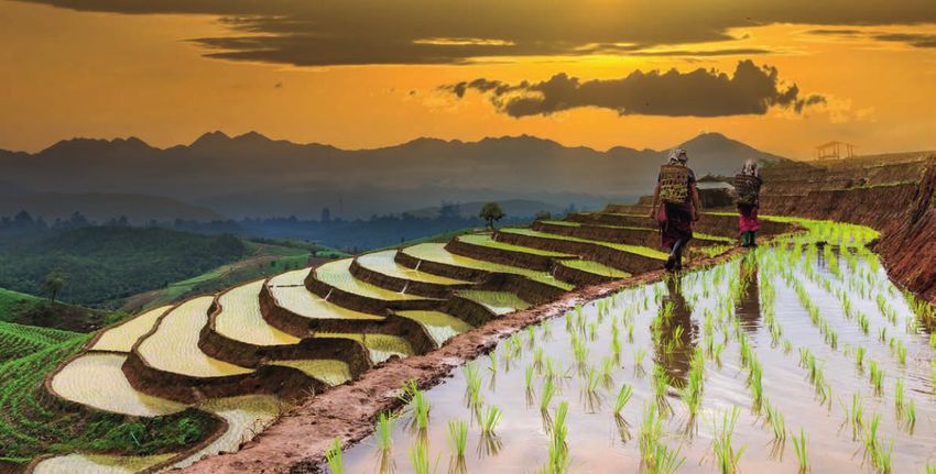
Publisher:
adelphi, Alt-Moabit 91, 10559 Berlin, Germany
Phone: +49 (0)30 89 000 68 0
Email: office@adelphi.de
Web: www.adelphi.de

ISBN:
978-3-942664-00-4

Proceedings of the GRoW Midterm Conference – Global analyses and
local solutions for sustainable water resources management.
Frankfurt am Main, 20-21 February 2019.

Contacts for the BMBF funding measure Water as a Global Resource

At BMBF:
Dr Christian Alecke
German Federal Ministry of Education and Research (BMBF)
Unit 724 – Resources and Sustainability
53170 Bonn
Email: christian.alecke@bmbf.bund.de

At PTKA:
Dr Leif Wolf, Romy Durst
Project Management Agency Karlsruhe (PTKA)
Karlsruhe Institute of Technology (KIT)
Hermann-von-Helmholtz-Platz 1
76344 Eggenstein-Leopoldshafen
Email: leif.wolf@kit.edu, romy.durst@kit.edu

Editors:
GRoWnet Networking and Transfer Project
Annika Kramer, Dr Sabine Blumstein, Theresa Lorenz, Elsa Semmling
adelphi research gemeinnützige GmbH
Alt-Moabit 91
10559 Berlin
Email: grownet@adelphi.de
Phone: +49 (0)30 89 000 68 281

Supported by the German Federal Ministry of Education and Research (BMBF)
Reference: 02WGR1420
The responsibility for the content of this publication lies entirely with the
authors of the individual contributions.

The brochure is not intended for commercial distribution.
Published February 2019

Graphics and layout:
Marina Piselli, Studio Grafico, Berlin

Printing:
Druckhaus Berlin-Mitte
©COVER FOTO: TZIDO SUN/Shutterstock, Rice terraced field, Mae Chaem,
Chiang Mai province, Thailand
Contents

 5   The GRoW funding measure

 6   Making GRoW more than the sum of its parts: The GRoW cross-cutting topics

 8   SaWaM: Seasonal water resource management for semiarid areas: Regionalized global data and
     transfer to practice

12   MuDak-WRM: Multidisciplinary data acquisition as key for a globally applicable water resource
     management

16   iWaGSS: Integrated Water Governance Support System

20   go-CAM: Implementing strategic goals in Coastal Aquifer Management

24   MedWater: Sustainable management of politically and economically highly relevant water
     resources in hydraulically, climatically and ecologically highly dynamic carbonate groundwater
     aquifers of the Mediterranean

28   TRUST: Sustainable, fair and environmentally sound drinking water supply for prosperous re-
     gions with water shortage: Developing solutions and planning tools for achieving the Sustainable
     Development Goals using the river catchments of the region Lima/Peru as an example

32   InoCottonGROW: Innovative impulses reducing the water footprint of the global cotton-
     textile industry towards the UN Sustainable Development Goals

36   WELLE: Water footprints in companies: Organizational Water Footprint – Local measures in global
     value chains

40   STEER: Increasing good governance for achieving the objectives of Integrated Water Resources
     Management

44   WANDEL: Water resources as important factor in the energy transition at local and global scale

48   GlobeDrought: A global-scale tool for characterising droughts and quantifying their impact
     on water resources

52   ViWA: Virtual Water Values

56   Contacts

                                                                                                        3
Victoria Falls on the Zambezi River, at the
    border between Zambia and Zimbabwe;
    Foto: Vadim Petrakov / Shutterstock

4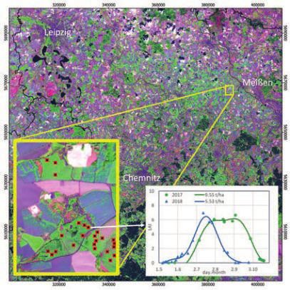
The GRoW funding measure
The United Nations’ 2030 Agenda for Sustainable Development emphasizes the global importance of water resources.
Sustainable Development Goal 6 (SDG 6) specifically aims to “ensure availability and sustainable management of water and
sanitation for all.” By 2030, everyone should have access to clean drinking water and adequate sanitation systems, and water-
related ecosystems should be protected or restored as natural resources. To help achieve SDG 6, the German Federal Ministry of
Education and Research (BMBF) has launched the funding measure Water as a Global Resource (GRoW), which is part of a
broader framework entitled Research for Sustainable Development (FONA). GRoW comprises twelve joint research projects
with more than 90 partner institutions from research, business and practice. The projects aim to develop innovative ways of
increasing governance capacities in the water sector while reflecting the close links between local and global action. This
approach will bring together science, policy and practice to connect key water topics, consolidate knowledge on implementing
the SDGs and thereby strengthen evidence-based decision-making. Each of the twelve projects addresses one of three overarch-
ing topics:

1. Global water resources
This topic focuses on innovative assessments and management tools for water resources and their related ecosystems. The re-
searchers derive action-relevant information from large volumes of raw data (e.g. from satellite-based remote sensing) and
explore how technology and innovative, solution-oriented models can be applied as compact solutions to improve information
flows. These solutions can significantly reduce the time between collecting data, analysing the need for action, and subsequent
management decisions taken by companies and authorities.

2. Global water demand
This topic focuses on analysing water demand and creating new incentive systems for using resources more efficiently. Future
water demand must be viewed in light of the nexus between water, food and energy so that the growing need for food and
renewable raw materials for energy can be taken into account. Water footprints and reliable, understandable forecasts of trends
in water demand are therefore important tools for decision-makers in businesses and authorities.

3. Good governance in the water sector
Good water governance is at the heart of the funding measure. It includes information on water resources, water demand and
innovative technologies. For this topic, researchers are developing methods and incentive mechanisms that consider societal
and individual motivations for sustainable water management. An important part of this involves measuring and documenting
progress on the SDGs. In particular, suitable indicators for the multidimensional concept of sustainability are being identified, and
their applicability verified.

The GRoWnet networking and transfer project                         twelve projects, representatives of the German Federal Ministry
The GRoW research activities are accompanied by GRoWnet,            of Education and Research (BMBF), Project Management Agen-
the networking and transfer project led by adelphi. GRoWnet         cy Karlsruhe (PTKA) and the GRoWnet networking and transfer
aims to identify and effectively use synergies between the          project. The objective of the steering committee is to increase
twelve joint research projects by strengthening cooperation         public outreach and practical applicability of the research activi-
and exchange between them. In addition, GRoWnet actively            ties. Input from the steering committee will help the GRoW
supports the projects in transferring and communicating             projects draft recommendations for making their research
their research findings and solutions to different target groups,   projects even more relevant in terms of achieving the SDGs.
such as the public, water experts, resource managers and
policymakers. In doing so, GRoWnet aims to increase the over-       Aim of this publication
all impact of the funding measure.                                  The present conference proceedings show the interim
                                                                    research results of the twelve GRoW projects. We hope that
The GRoW steering committee                                         this will provide the foundation for a fruitful discussion with
The GRoW steering committee supports the work of the research       water experts from academia, policy and practice. In particu-
projects. It consists of six external experts from development      lar, we want to explore the opportunities and challenges for
cooperation, policymaking and business, the coordinators of the     transferring GRoW research results into practice.

                                                                                                                                          5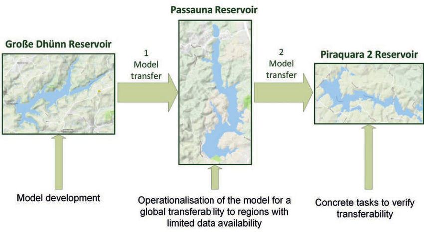
Making GRoW more than the sum of its parts:
    The GRoW cross-cutting topics

    Although the twelve GRoW research projects cover very             Incentive mechanisms in the context of
    diverse topics, a number of thematic and methodological           governance
    overlaps exist. In order to harness synergies and ensure that
                                                                      Coordinators:
    knowledge is shared across the individual projects, partici-
                                                                      Prof Karl-Ulrich Rudolph (IEEM GmbH)
    pants are addressing a series of cross-cutting topics. These
                                                                      Alexander Grieb (formerly KfW)
    activities are designed to increase the impact of GRoW as a
    whole.                                                            A number of the GRoW joint research projects are working on
                                                                      incentive mechanisms (e.g. economic, legal and reputational)
    Under the direction of the steering committee, GRoW has so
                                                                      to encourage better water resources management. However,
    far defined and is working on three cross-cutting topics:
                                                                      much like the effectiveness of new technologies and proces-
    1. Incentive mechanisms in the context of governance              ses, the impact of these tools depends heavily on the political
                                                                      and social frameworks in the target regions. At the first mee-
    2. SDGs (Sustainable Development Goals): Hitting the              ting of the cross-cutting topic, participants therefore decided
       targets                                                        to work on the link between the macro and micro level of
    3. Water footprints                                               water governance, which implies scaling down the focus to,
                                                                      for instance, the level of water utilities in order to achieve SDG
    Work on these cross-cutting topics requires partners who are      6. In addition, three sub-working groups were defined:
    willing to invest time and energy, and are eager to engage
    with fellow researchers. Each topic therefore has a coordinator   • Irrigated agriculture: This group focuses on legal frame-
    who directs the work and collaborates with GRoWnet to               works and the potential of social innovations and digitalisa-
    organise various meetings. Two rounds of workshops and              tion in the agricultural sector.
    several online meetings have taken place so far. For updates
    on the activities of the cross-cutting topics, see the GRoW       • Measuring governance: This group facilitates inter-project
    website: www.bmbf-grow.de.                                          exchange on operationalising governance and defining
                                                                        governance indicators for measurement purposes.

                                                                      • Turning governance research into practice: This group
       A visible example is the joint GRoW position paper               assesses the link between the macro and micro level and
       prepared to inform the meeting of the High Level                 collects aspects of good governance from the projects,
       Political Forum on SDG6 in 2018 in New York. The                 since general principles of governance do not always fit the
       paper is available for download at the GRoW website.             water sector.

6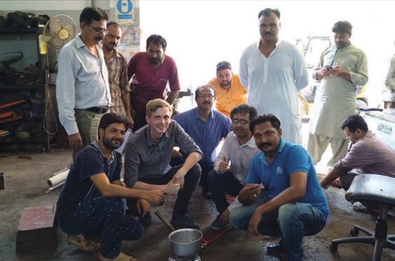
SDGs: Hitting the targets                                          Water footprints

Coordinators:                                                      Coordinators:
Prof Claudia Pahl-Wostl (University of Osnabrück)                  Dr Markus Berger (TU Berlin)
Dr Ursula Eid                                                      Dr Falk Schmidt (IASS Potsdam)

Helping achieve the SDGs in general, and SDG 6 in particular,      Trade in virtual water is increasingly creating global links
is a key objective for all the GRoW research projects. They        between local and regional water resources. Several of the
develop and test innovative approaches to achieving the            GRoW research projects therefore investigate how consump-
goals and are also devising new concepts and key figures for       tion is linked to and affects water resources in other parts of
evaluating progress on the goals. This cross-cutting topic         the world. They develop methods for measuring water foot-
addresses issues related to achieving SDG 6 and leverages          prints in order to identify areas where water is being used
synergies to create an effective network for strengthening         inefficiently, and implement practical measures for reducing
and effectively demonstrating the ways in which the individu-      water footprints. In the past two workshop meetings, the
al projects and the overall GRoW funding measure are helping       GRoW projects discussed three major topics:
to make the SDGs a reality.
One concrete result of the group’s work so far is the afore-       • Mitigation: How can water footprints be reduced? How can
mentioned GRoW position paper highlighting what the GRoW             the water footprint be used to guide mitigation? And how
projects see as the key challenges to achieving SDG 6 and how        can it help to assess the effectiveness of mitigation measu-
they envisage contributing to the SDG 6 process. This paper has      res?
since been channelled into the political process on SDG 6
                                                                   • Impact assessment: How can water footprints be linked to
monitoring and has received positive feedback from a number
                                                                     economic and social impacts? How can trade influence
of institutions. The projects also identified a number of topics
                                                                     water stress in certain regions and vice versa? What are the
that are most relevant for their work, and are currently focus-
                                                                     links to mitigation strategies?
ing on two topics:

• Conflicting goals and synergies between different SDG            • Water quality: How can aspects of water quality (including
  targets: This group decided, based on case studies from            groundwater) be more effectively included in water foot-
  within GRoW, to develop a new assessment procedure for             print assessments?
  evaluating projects and/or different policy plans and their
                                                                   To collect and disseminate their findings on these questions,
  effects on SDG interactions.
                                                                   participants in this cross-cutting topic are currently compiling
• Indicators, data and models: This group aims to collect          a position paper. It will critically discuss the quantitative
  examples from GRoW on how the SDG 6 monitoring                   approach to water footprints, highlight which factors should
  process can be improved and augmented to provide                 be included and how this can be done, and analyse the
  insights for more sustainable water resources management.        potential and limitations of water footprints based on scienti-
                                                                   fic discussions from the perspective of GRoW.
Both groups are currently working on specific outputs to
summarize and disseminate their findings. These include
policy briefs and an event at the Stockholm World Water
Week.

                                                                                                                                      7
GRoW – WATER AS A GLOBAL RESOURCE

                               SaWaM: Seasonal water resource management for semiarid
                               areas: Regionalized Global Data and transfer to practice

    Using seasonal forecasts to support climate proofing
    and water management in semi-arid regions
    Christof Lorenz, Harald Kunstmann, Tanja Portele, Anita Bayer, Patrick Laux, Anne Müller, Gerd Bürger, Axel Bronstert,
    Nazli Turini, Boris Thies, Anna Smetanova, Eva Paton, Pallav Kumar-Shrestha, Luis Samaniego, Saskia Förster, Robert
    Behling, Siegrid Roessner, Sajedeh Behnia, Nico Sneeuw, Berhon Dibrani, Thomas Kukuk
    Full information on author affiliations can be found p. 56/57

    Keywords: Seasonal forecasts, semi-arid regions, sustainable water management, climate proofing

    ABSTRACT

    In our project Seasonal Water Resources Management: Regionalized Global Data and Transfer to Practise (SaWaM), we analyse the
    potential of global hydrometeorological information for supporting the regional water management, particularly reservoir oper-
    ation. Special focus is on seasonal forecasts, with which we aim to predict the availability of freshwater resources and the state of
    the ecosystem for up to 6 months in advance. This is achieved by a strongly interlinked model and data chain. After an in-depth
    evaluation during the period 1981 to 2010, global data sets are processed for regional water management purposes through
    dynamical and statistical downscaling approaches, hydrological and ecosystem modelling as well as the combination with
    remote-sensing-based information. To assess the transferability of our tools and products, we focus on eight different semi-arid
    basins in Iran, Sudan, Brazil, Ecuador, and West-Africa. The transfer into practice is ensured through the close cooperation with
    regional stakeholders, decision makers, research institutes, and water managers as well as the joint development of a tailor-made
    online decision support system for regional water management. The project also serves as a benchmark for the application of
    state-of-the-art seasonal forecast products. In-depth comparisons with reference datasets show a promising forecast skill, which
    allows e.g. for the prediction of the intensity of rainy seasons and droughts. The project is therefore strongly contributing to
    climate proofing and the accomplishment of SDG 6, that is to ensure the availability and sustainable management of water and
    sanitation for all, in particular in semi-arid regions.

    INTRODUCTION                                                            decrease in the number of hydrometeorological in situ
                                                                            stations (Lorenz and Kunstmann, 2012) and high uncertainties
    While weather forecasts are used for flood warnings and while           in estimates for the current and future water supply (Pilgrim et
    climate projections are used for long-term climate adaptation           al., 1988), this is getting increasingly difficult. Scientists and
    measures, it is the knowledge of the climate of the coming              decision makers may therefore rely their planning more and
    months (Siegmund et al., 2015) that is crucial for the manage-          more on global hydrometeorological data sets, remote-
    ment and control of water reservoirs, e.g. for power gener-             sensing products, or global model systems. It is SaWaM‘s goal
    ation or for irrigation in agriculture. This is particularly relevant   to investigate the performance of such global information
    in dry regions, i.e. arid and semi-arid areas. In semi-arid regions,    and, in particular, global seasonal forecasts for which we
    unlike in arid regions, much can be achieved with sustainable           develop methods and tools for the regionalization, the
    and science-based water resource management. It is there-               processing and, in the end, the transfer into practice for the
    fore of utmost importance to understand the local climate               regional water management in semi-arid regions. We focus on
    system including the dynamics and interactions of different             semi-arid regions in Brazil (Rio São Francisco basin), Iran (Karun
    water-related variables. However, due to the significant                and Lake Urmia basins), Sudan (Blue Nile and Atbara basins),

8
SaWaM

Ecuador (Catamayo-Chira basin), and West-Africa (Niger and                       casts and either a gridded high-resolution reference dataset
Volta basins). We further aim at the direct transfer to practice                 or in-situ observations. For the latter, we use the Expanded
through a close cooperation with regional stakeholders, deci-                    Downscaling (XDS, Bürger, 1996), which assumes that local
sion makers, and scientists. In the end, this cooperation shall                  climate covariance is linked bilinearly to the global circulation
demonstrate the potential of seasonal forecasts for climate                      covariance. We also apply uni- and multivariate bias-correc-
proofing and for regional water management even beyond                           tion and spatial disaggregation (BCSD, e.g. Lorenz et al., 2018)
the project duration and our study regions.                                      techniques, which are a compromise between the computa-
                                                                                 tionally expensive dynamical downscaling approaches and
                                                                                 XDS, which provides information at selected stations only.
                                                                                 State of the hydrosystem: In order to get information about
METHODS
                                                                                 hydrological variables like streamflow and soil moisture but
In SaWaM, we follow an interlinked chain of models and data                      also the transport and entry of sediments, we use the down-
in order to process global seasonal forecasts and other infor-                   scaled seasonal forecasts as driving data for two hydrological
mation for regional water management. While each sub-                            models, namely the mesoscale Hydrological Model (mHM,
project requires specific data (e.g. runoff observations for                     Samaniego et al., 2010) and the Water Availability in Semi-Arid
hydrological modelling), all sub-projects use seasonal fore-                     environments – SEDiments (WASA-SED, Mueller et al., 2010)
casts from the European Centre for Medium-Range Weather                          model. The mHM-model with its different modules allows for
Forecasts (ECMWF), namely Version 5 of ECMWFs Seasonal                           a straightforward modelling of the catchments even if only
Forecasting System (SEAS5).                                                      limited local information is available. This is possible through
Regionalization: Small scale precipitation variability cannot                    mHMs multi-scale parameter regionalization technique, with
be resolved at the initial resolution of the global seasonal fore-               which we assimilate and incorporate different satellite- and
casts. For improving this resolution, we follow two regionaliza-                 station-based observation datasets with different spatial reso-
tion approaches. High-resolution information is modelled                         lutions. The WASA-SED-model, on the other hand, requires
with the Weather Research and Forecasting model (WRF).                           detailed information about the catchment. Then, by including
After finding a suitable parametrization for e.g. model physics                  the description of processes for erosion at the hillslope scale,
of convection or radiation for each target region, this model                    for transport of suspended and bedload fluxes at the river
allows us to provide information about precipitation and                         scale and the retention and remobilisation of sediments in
temperature down to a resolution of 3km, i.e. convection                         large reservoirs, it provides all relevant information for the
permitting scales. As this so-called dynamical downscaling                       regional water management especially in semi-arid regions.
requires huge computational resources, we also apply statisti-                   State of the ecosystem: In order to predict the state and
cal approaches, where the interpolation of precipitation and                     functionality of the ecosystem including indicators for eco-
other climatic variables to a higher resolution is based on                      system services for the next season, the global dynamic vege-
statistical relationships between the coarse-scale global fore-                  tation model LPJ-GUESS is modified for the application on the

      Figure 1: The drought in Iran from winter 2017/2018 picked up by different methods applied in the SaWaM project: (a) Drought index SPI3 from Monitoring
    (GPCC v6.0 for Dec 2017 to Feb 2018), (b) SPI3 from seasonal forecast system (ECMWF SEAS5, for Dec 2017 to Feb 2018) and (c) as detected by remote sensing
  (relative NDVI Anomaly from MODIS during the period Dec 2017 to Feb 2018 with respect to the long-term mean for 2001 to 2018). For the SEAS5-forecast, only
                                                                                                   the SPI-category with the most ensemble members is shown.

                                                                                                                                                                 9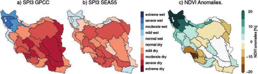
GRoW – WATER AS A GLOBAL RESOURCE

     regional scale. Ensemble simulations will identify how uncer-       ated the performance of our different tools and products
     tainties in the amount of precipitation and its temporal and        during the 2017/2018 drought in Iran. Besides the evaluation
     spatial distribution are reflected in crucial ecosystem services,   of the performance of the precipitation forecasts, we are
     such as crop yields, carbon sequestration and ecosystem             interested in the implications of such a drought on the eco-
     water balance. A semi-parametric approach is used to identify       system. While the prediction of ecosystem states is still work
     areas with degraded vegetation and soils, which contribute          in progress, we can already use satellite-based information in
     significantly to the infilling of reservoirs by sediments. In       order to assess the condition of the vegetation during this
     particular, sediment transport is approximated through a            season. Figure 1 therefore shows the Standardized Precipita-
     function of precipitation, connectivity, soil and vegetation        tion Index (SPI), an index for meteorological droughts, and the
     properties. This allows us to prepare and test land manage-         differences between the vegetation climatology and the
     ment scenarios in degraded areas in order to prevent siltation.     conditions during the rainy season 2017/2018. Comparing
     Validation: We develop and apply several remote-sensing             the GPCC-Monitoring product (Figure 1a) with the SEAS5-
     based approaches for validating the different derived prod-         forecasts (Figure 1b) clearly shows that the low amount of
     ucts. In particular, we use data from the Global Precipitation      precipitation was successfully predicted by the seasonal
     Measurement (GPM) mission, which is combined with infor-            forecasts. The impact on the vegetation, however, shows a dry
     mation from high-resolution optical sensors on board of             signal especially in the regions which are dominated by
     geostationary satellite systems like the Meteosat Second            natural vegetation or low population (Figure 1c). In heavily
     Generation. A newly developed rainfall retrieval technique,         irrigated areas like the Karun basin, vegetation is even slightly
     based on a random forest machine learning approach, allows          increasing, which indicates that despite the low freshwater
     for a quasi-continuous observation of rainfall distribution in      resources, the available water has been used for irrigation in
     near–real time and in high spatial and temporal resolutions.        order to maintain food supply. This caused water shortages for
     Runoff is estimated from spaceborne altimetry sensors by            other sectors like, e.g. drinking water, leading to protests and
     computing a statistical relationship between altimetry-based        revolts especially in the Southern parts of Iran at that time.
     water level time-series and observed runoff. Water levels can       Atmospheric, hydrological and ecosystem modelling: For
     then be transformed into runoff even if the gauge-based             all modelling approaches, we finalized the initial setups and
     observations are discontinued. Finally, time series of optical      first parametrization experiments. The hydrological modelling
     remote sensing data of varying spatial (Sentinel-2, Landsat,        for the headwaters of the river basins using mHM shows
     MODIS at 10m – 1000m pixel size) and temporal scales                already highly promising results and will be used in an opera-
     (decades to seasons) are used to derive long-term and sea-          tional setup after the implementation of a lake module. The
     sonal vegetation dynamics patterns.                                 LPJ-GUESS model has been used for modelling the ecosystem
                                                                         of the Rio São Francisco basin in particular during dry periods
                                                                         in order to assess the implications on the vegetation. First runs
     SELECTED INTERIM RESULTS                                            show a significant drought signal in both the vegetation
     AND DISCUSSION                                                      parameters and also the excess water, which already indicates
                                                                         the potential of the LPJ-GUESS-model to assess changes in
     Evaluation of the SEAS5 seasonal forecasts: For evaluating          the vegetation that are driven by water availability.
     the performance and the forecast skill of SEAS5 seasonal            Public relations: Due to the strong focus on the involvement
     predictions, we have compared the precipitation forecasts           of stakeholders, decision makers, and other potential users,
     against gridded observation-based datasets from the Global          we have organized workshops in our study regions in Brasília
     Precipitation Climatology Centre (GPCC) in terms of accuracy,       (Brazil), Ahvaz and Teheran (Iran), and Khartoum (Sudan). With
     overall performance, sharpness, and reliability, which is           up to 100 participants, these workshops have shown the great
     expressed in the so-called Unified Skillscore. After a basic        interest not only in our tools and methods, but in seasonal
     multiplicative bias correction, we can observe skilful predic-      forecasts and climate proofing approaches in general. Besides
     tions for the seasonal precipitation sums during the rainy          site visits in the different basins, we also organized training
     season already two months (São Francisco, Karun, Urmia,             courses e.g. for dynamical and statistical downscaling. Special
     Catamayo-Chira, Blue Nile) or one month ahead (Atbara,              highlights have been the presentation of SaWaM at side
     Niger, Volta).                                                      events both at the 8th World Water Forum in Brasília, Brazil,
     The 2017/2018 drought in Iran: For testing the potential as         and the 24th Conference of the Parties (COP24) in Katowice,
     regional decision support for water management, we evalu-           Poland.

10
SaWaM
CONCLUSIONS & OUTLOOK effort, because, even if the project also includes the regional
application of globally available data, the detailed evaluation
In the SaWaM-project, we evaluate the performance of global of our products as well as the quantitative analysis of regional
hydrometeorological information and, in particular, seasonal climate systems still require in-situ information which, how-
forecasts, for the regional water management in semi-arid ever, is often hard to obtain and/or inconsistent.
regions. Since the project start we have made significant During the kick-off workshops in our study regions and sev-
progress especially in the understanding both the potential eral side events, we have learned that regionalized seasonal
and the limitations of seasonal forecast products and their forecasts and the derived products for the hydrological
usage in different modelling approaches. While the regional systems and ecosystems have a huge potential for predicting
adaptation especially for the hydrological and ecosystem and therefore mitigating the impact of extreme events like
models is still ongoing, the production of statistically correc- droughts. The products, tools and methods that are devel-
ted seasonal precipitation forecasts as well as the remote- oped in SaWaM are a benchmark for the application of
sensing based monitoring of precipitation, runoff and vegeta- seasonal forecasts for the regional water management and
tion parameters is almost in an operational status. Besides therefore contribute to climate proofing in particular in
that, we follow the collection of regional data with a high semi-arid regions.
Contact
Coordinator: Prof Harald Kunstmann
Karlsruhe Institute of Technology
Institute of Meteorology and Climate Research
Tel.: +49 8821 183 208
E-mail: Harald.Kunstmann@kit.edu
Website: www.grow-sawam.org
BMBF Project ID: 02WGR1421A-I
LIST OF REFERENCES
Bürger, G. (1996). Expanded downscaling for generating local weather scenarios. Climate Res., 7, 111–128, doi: 10.3354/cr007111
Lorenz, C., H. Kunstmann (2012). The Hydrological Cycle in Three State-of-the-Art Reanalyses: Intercomparison and Performance Analysis,
Journal of Hydrometeorology, 13, 1397 - 1420 doi: 10.1175/JHM-D-11-088.1
Lorenz, C., C. Montzka, T. Jagdhuber, P. Laux, H. Kunstmann (2018). Long-Term and High-Resolution Global Time Series of Brightness Tem-
perature from Copula-Based Fusion of SMAP Enhanced and SMOS Data. Remote Sens., 10, 1842, doi: 10.3390/rs10111842
Mueller, E., A. Güntner, T. Francke (2010). Modelling sediment export, retention and reservoir sedimentation in drylands with the WASA-SED
model, Geosci. Model Dev., 3, 275-291, doi: 10.5194/gmd-3-275-2010
Pilgrim, H. D., G. Chapman, D. G. Doran (1988). Problems of rainfall-runoff modelling in arid and semiarid regions. Hydrological Sciences
Journal, 33, 379-400, doi: 10.1080/02626668809491261
Samaniego L., R. Kumar, S. Attinger (2010). Multiscale parameter regionalization of a grid-based hydrologic model at the mesoscale. Water
Resour. Res., 46, W05523, doi: 10.1029/2008WR007327.
Siegmund, J., Bliefernicht, J., Laux, P., Kunstmann, H. (2015). Toward a seasonal precipitation prediction system for West Africa: Perfor-
mance of CFSv2 and high-resolution dynamical downscaling, Journal of Geophysical Research-Atmospheres, 120, 7316–7339, doi:
10.1002/2014JD022692
11GRoW – WATER AS A GLOBAL RESOURCE
MuDak-WRM: Multidisciplinary data acquisition as key
for a globally applicable water resource management
Sustainable management of reservoirs – defining
minimum data needs and model complexity
Stephan Fuchs, Stephan Hilgert, Klajdi Sotiri, Adrian Wagner, Mayra Ishikawa, Jens Kern, Simon Jirka, Irina Klassen,
Julia Krumm, Christian Malewski, Harald Rohr, Kian Pakzad
Full information on author affiliations can be found p. 58
Keywords: Minimum monitoring, reduced model complexity, catchment, reservoir, water quality
ABSTRACT
The overall objective of the MuDak-WRM project is the development and application of a globally applicable management
system for reservoirs and their basins. To succeed in this development, two major sub-goals have to be fulfilled. We will develop
a methodology for a minimum monitoring to assess water quality. Additionally, the complexity of existing models needs to be
reduced, to address globally restricted data and budget availability. The project includes monitoring of catchment and in-lake
processes. Two case study sites were selected beforehand, the Große Dhünn reservoir in Germany and the Passauna reservoir in
south-east Brazil. The monitoring results used for model parametrization lead to an improved system understanding, which
again is the basis to define crucial monitoring parameters in space and time. With this information the efforts for an effective
water quality observation will be reduced. A continuous assessment of the mass flux into the reservoir, water quality changes
inside the reservoir as well as seasonal land cover changes have been successfully monitored in high resolution for an entire year.
At the same time a water balance model has been set up in close relation to a catchment emission model.
INTRODUCTION reservoir operators are too complex and data demanding for
a world wide application. Limited understanding of processes
The core product of MuDak-WRM is a model for the prediction in the catchment and the reservoir, so far hinders the devel-
of medium to long term changes in water quality in reservoirs opment of simplified approaches. The project hypothesis is,
which is as simple as possible and uses globally available data. that water quality of reservoirs changes on long-term scales
The key aspect is to reduce the complexity of the underlying due to changes in the catchment (input fluxes), and that these
scientific-mathematical approaches and the data required for reactions can be modelled and verified by the assessment of
the future model to enable the application of the model with monitoring data. The MuDak team aims at providing an appli-
reasonable effort and in a meaningful way in developing cable approach, which can be used by international reservoir
countries. The interdisciplinary research group on the German operators and authorities to describe the actual status of one
side is a consortium of four research and five industry part- reservoir and to assess the potential future development of
ners. Each work package is handled by one or two German water quality under consideration of certain management
partners. On the Brazilian side, three research and four indus- options, like afforestation and waste water treatment plant
try or public partners are involved in the project, so that the development. This approach will deliver answers to achieve
areas of competence are mirrored. In most cases the used the sustainable development goals (SDGs).
models for water quality prediction and decision support for
12MuDak-WRM
METHODS urement data exchange among software components. This
framework is called the Sensor Web (Botts et al. 2008).
To solve the addressed challenges and to answer the scientific The principal workflow is developed along two reservoir case
questions the project consortium is split into three methodo- studies (Figure 2). The first region, Große Dhünn reservoir
logical-technical parts. Three work packages produce primary (managed by Wupperverband), is used as a “best case” sce-
data from field measurements, which is passed on for in-situ nario in terms of data availability. The developed models are
verification and the validation of models. Three work pack- transferred to Passauna reservoir (managed by Sanepar),
ages set up and adapt a water balance model (LARSIM) where a long time series of quality data and catchment infor-
(Ludwig & Bremicker 2006), an emission model (MoRE) (Fuchs mation is missing. After further development and reduction a
et al., 2017) and a hydrodynamic model combined with a final simplified model version will be produced. This model
water quality- and sediment transport model (Delft 3D) for will be applied by the reservoir operator in the Piraquara 2
the case study and derive approaches for a reduction of catchment to predict water quality changes of the reservoir.
complexity (Figure 1). In order to reduce the complexity, the By the transfer to a new catchment the functionality as well as
models are first developed to run with the best possible input the transferability of the product can be assessed.
data. From this stage on the input data will be reduced in Monitoring encompasses activities in the catchment like
terms of temporal and spatial resolution as well as measure- continuous water sampling at the river inflow to assess the
ment quality itself. Unnecessary model parts can be excluded particle and nutrient flux to the reservoir, sediment and soil
from the calculations to reduce complexity. The aim is to find sampling and the analysis of satellite imagery (Sentinel-1 with
the minimum data demands for the models and to still repro- radar sensor and Sentinel-2 with optical sensor, revisiting time
duce the critical water quality status in a reservoir and the of ca. 6 days) to retrieve land use and land cover change and
related long-term usage of the reservoir. The third part works further model input parameters like Albedo- and LAI (Leaf
on the integration of both, campaign-based and as real-time Area Index).
data, into a web framework that allows for standardized meas-
Figure 1: Methodological project approach.
13GRoW – WATER AS A GLOBAL RESOURCE
Figure 2: Model development and case study transfer work flow
Reservoir monitoring includes real-time water quality measure- ment campaigns. All data is available to researchers and the
ments on a platform (Figure 3) at the water intake in Passauna operators in a standardized manner.
reservoir combined with monthly water sampling campaigns. Sedimentation assessment revealed that the siltation process
Additionally an upward looking Acoustic Doppler Current in the pre-dam of the Große Dhünn reservoir is relatively slow
Profiler gives insights in internal flow velocities and flow direc- due to limited erosion in the catchment. In contrast to this,
tions. The detailed investigation of in lake processes is comple- the Passauna reservoir is affected by significant siltation and
mented by campaign-based drone flights to better under- accumulation of nutrients, even though the actual status is
stand the spatial distribution of quality parameters (e.g. mesotrophic. Continuous water sampling is ongoing and
turbidity and chlorophyll conc.) and to bridge the information therefore final data and water quality model results are not
to the satellite imagery. available yet. However, for the big pre-dam of the Dhünn
reservoir, the impact of various numerical and physical para-
meters was examined in sensitivity analyses adopting a 3D
model. Collected input data for the hydrological model and
INTERIM RESULTS AND DISCUSSION the emission model was pre-processed and the first model
runs were conducted. At the moment the modelled water
During four individual large measurement campaigns at balance is integrated into the emission model to calculate the
Passauna and three measurement campaigns at the Große sediment and nutrient flux into the reservoirs. The emission
Dhünn Reservoir pre-dam the actual ecological and opera- model results then will be validated by the measured fluxes in
tional state of the reservoirs was evaluated. Water quality the rivers.
sensors were successfully tested at the Große Dhünn reservoir Partners from all work packages participated in an extended
and were installed permanently later on in the Passauna training and transfer session during five days. In parallel to the
reservoir. The Wupperverband has been operating a Sensor monitoring activities, the applied methods and tools were
Web framework since more than ten years and serves a explained to employees from the operating company in theo-
smaller set of real-time-data for the reservoir. During the ry as well as in the field. Additionally, bi- and trilateral meet-
project this homogeneous measurement data pool is ex- ings took place to exchange work package-specific demands
tended by sampling data, taken during the project measure- from the company and authorities.
14MuDak-WRM
CONCLUSIONS & OUTLOOK On a cooperation level, the MuDak-team is exited, that an
intense and fruitful cooperation was established with Sanepar,
In order to investigate the formulated research hypothesis a Brazilian reservoir operator as well as two Brazilian universi-
and to increase the process understanding as well as to ties (Federal University of Paraná and University Positivo),
reduce the model complexity and data demand, the follow- several authorities and The Nature Conservancy (TNC).
ing steps have been accomplished so far. In February 2019 the Sanepar contributed to the project with logistics, data access
one year continuous measurement will be completed and and even funding to purchase a joined research vessel. The
obtained data will be processed to feed the models. The universities contribute by providing 10 scholarships for PhD
following steps were completed successfully: students working on different parts of the MuDak project.
· One year of continuous input flux monitoring at the After the finalization of the models (LARSIM, MoRE and Delft
Passauna River. 3D) the sensitivity analysis will be performed. The models will
be tested to produce relevant and correct results with reduced
· Using satellite remote sensing to derive land use classes
and simplified input data. Towards the end of 2019 central
and several model parameter values
quality parameters together with temporal and spatial resolu-
· Long-term high-resolution measurements of water tion demands will be defined. The Sensor Web framework,
quality in the reservoir and over 10 intensive sampling which already organizes data for the Große Dhünn reservoir
campaigns conducted. will be extended with data from Sanepar to seamlessly access
and visualize information on the Web. Not only will the prod-
· Testing of cutting-edge monitoring technology (hyper-
uct be introduced to potential users, but also will we distrib-
spectral sensors (drone- & boat-based), sediment pen-
ute the scientific and technical outcomes to a broad range of
etration measurements, optical in-situ quality sensors)
target groups inside and outside the scientific community.
· Real-time water quality data integration with the Sensor Web
The MuDak-WRM team thanks all Brazilian partners and espe-
· 3D numerical sensitivity analyses for one pre-dam of the cially the colleges from Sanepar and the UFPR for huge efforts in
Dhünn reservoir focusing on the effect of stratification the field, laboratory and for a great cooperation.
processes on fine sediment transport.
· Watershed emission modelling and water balance
modelling completed.
Contact
Coordinator: Prof Stephan Fuchs Tel.: +49 721 608- 4 6199
Karlsruhe Institute of Technology E-mail: fuchs@iwg.uka.de
Institute for Water and River Basin Management, Website: http://www.mudak-wrm.kit.edu/
Department of Aquatic Environmental Engineering BMBF Project ID: 02WGR1431A-G
LIST OF REFERENCES
Fuchs, S.; Kaiser, M.; Kiemle, L.; Kittlaus, S.; Rothvoß, S.; Toshovski, S.; Wagner, A.; Wander, R.; Weber, T.; Ziegler, S. (2017). Modeling of Regio-
nalized Emissions (MoRE) into Water Bodies: An Open-Source River Basin Management System. Water 2017, 9, 239, doi:10.3390/w9040239
Ludwig, K.; Bremicker, M. (2006). The Water Balance Model LARSIM - Design, Content and Applications. Institut für Hydrologie der Albert-
Ludwigs-Universität Freiburg im Selbstverlag (Freiburger Schriften zur Hydrologie, 22).
Botts, M., Percivall, G., Reed, C., & Davidson, J. (2008). OGC® sensor web enablement: Overview and high level architecture. In GeoSensor
networks (pp. 175-190). Springer, Berlin, Heidelberg.
15GRoW – WATER AS A GLOBAL RESOURCE
iWaGSS: Integrated Water Governance Support System
Integrated solutions for water resources management
and governance
Jens Hilbig, Karl-Ulrich Rudolph, Dariusz Musiol on behalf of the iWaGSS project
Full information on author affiliations can be found p. 59
Keywords: Water governance, realtime water management, sustainable resources management, river and reservoir
modelling, water quality monitoring
ABSTRACT
The objective of the research project iWaGSS is the development and practical pilot implementation of an innovative water gover-
nance system based on new technologies and tools for mitigating water stress and for sustainable management of the water
resources in the South African pilot region as well as in other regions with overstressed water resources in Africa and worldwide.
Based on four main components – real-time online monitoring, hydrological modelling, risk assessment and socio-economic
analysis – the sustainable water governance system (Figure 1) will support decision makers and improve governance processes
in the water sector. By increasing the efficiency of water utilisation and protecting natural resources and ecosystems, the iWaGSS
project shall contribute to solve the urgent challenges of the global resource water and to achieve the sustainable development
goals (SDGs). The iWaGSS consortium consists of eight German partners from research and practice: Institute of Environmental
Engineering and Management at Witten/Herdecke University, Environmental Engineering and Ecology – Ruhr-University
Bochum, Institute for Water and River Basin Management – Karlsruhe Institute of Technology, Center for Development Research
– University of Bonn, Disy Informationssysteme, LAR Process Analysers AG, Global Water Franchise Agency and Die Gewässer-
Experten! The German partners are working in close cooperation with South African partners and stakeholders from public
administration, academia, development cooperation, industry and civil society. Up to now, several field campaigns have been
conducted to collect data and to assess the situation in the pilot region. The installation of the monitoring stations is in a final
stage. The current project status and the main components have been presented and discussed with local cooperation partners
and stakeholders in several work-
shops and meetings. The iWaGSS
project has been considered by
South African National Parks as
essential for the Kruger National
Park. SANParks supports the
project with own resources and
logistical assistance.
Figure 1: iWaGSS Realtime Water
Management System.
16iWaGSS
INTRODUCTION world-famous Kruger National Park serves as a flagship
project for the global dissemination of the modular iWaGSS
The Lower Olifants sub-catchment in South Africa has been water management system.
chosen as the primary iWaGSS demonstration area including
the Phalaborwa pilot zone (Figure 2). This pilot region has been
selected in close cooperation with South African partners and
METHODS
stakeholders because the development of the region in terms
of its ecological diversity and sustainability as well as econo-
The project consists of 10 work packages:
mic progress and social stability is particularly vulnerable to
water-related problems, including transboundary water 1. Water Governance
issues. Thus, the chosen area can be seen as representative for With a focus on economic aspects of governance and
other basins and should be appropriate to proof scalability micro-level governance
and transfer of research and innovation results to other regions.
2. Risk Assessment and Hydrological Modelling
A combination of risk assessment tools and a 1-D hydro-
logical model of the river system
3. Reservoir Modelling
Numeric hydraulic modelling and morphodynamic simu-
lation of the Phalaborwa Barrage
4. Realtime Water Quality Monitoring
Installation and operation of a network of water quality
monitoring stations
5. Data Management and Data Integration
Development of a GIS-based realtime decision support
and management system
6. Adapted Operation and Management Concepts
Including wastewater management, water quality and
Figure 2: iWaGSS pilot zone. emissions as well as water reuse
7. Transboundary Governance
Water uses and economic activity in the Olifants basin are Focusing on impacts of transboundary water governance
diverse and range from mining, power generation, metallur- on people and nature protection
gic industries, irrigation, subsistence agriculture and eco- 8. Remote Sensing
tourism. The Lower Olifants sub-catchment is part of the Use of drones for river monitoring
UNESCO Kruger to Canyons Biosphere Reserve. This region –
9. Capacity Development
which includes the world renowned Kruger National Park
Workshops and trainings
(KNP), rural and peri-urban areas, copper and phosphate
mining, subsistence and commercial farming – receives all the 10. Dissemination and transfer of results
consequent pressures from upstream parts of the basin. The Transfer of iWaGSS tolls and results to other river basins
water quality of the lower Olifants River is influenced, inter
alia, by return flows from mining and agriculture, for example
in the Ga-Selati River. Deteriorating water quality at catch-
ment scale (Ashton & Dabrowski, 2011) is not only threatening INTERIM RESULTS AND DISCUSSION
human health and KNP’s animals and ecosystems but also the
wide variety of ecosystem goods and services (EGS) that the Water Governance
catchment provides to society. To improve the status of the Analysing water governance institutions and transboundary
river and to strengthen the institutional governance frame- water governance in the Lower Olifants catchment, the
work in the region, a real-time water management system is project focuses on economic aspects of governance. With
to be developed. The practical demonstration area with the regard to the South African institutions, an implementation
17GRoW – WATER AS
AS A
A GLOBAL
GLOBALRESOURCE
RESOURCE
gap can be identified: South Africa has established a world- conductivity, redox potential and weather/climate data.
wide acknowledged body of water legislation (National Water A large volume sampler has been installed at the Oxford sta-
Act 1998), but is struggling with its implementation. The tion to determine the mass of transported sediments. Addi-
implementation gap between the macro level (legislation, tional turbidity probes have been installed at Oxford and
institutional framework) and the micro level (local institutions Sawong.
and water management practice) leads to water crisis, deteri-
oration of resources, collapsing infrastructure and substan- Field campaigns
dard services. Informal institutions and stakeholder groups are Additional data (including aerial pictures, river-cross sections
taking over some of the administrative and management of the Olifants and Selati River as well as some minor tribu-
functions (cf. Pollard et al 2011). iWaGSS is now focusing on taries upstream KNP, bathymetric and sediment remobilisa-
utility governance on a micro-level scale taking (financial) tion studies of the Phalaborwa barrage) has been collected
incentives and economic aspects into account. With regard to during several field campaigns (Figure 3) using portable
transboundary water governance, the main issues are the equipment like drones, acoustic doppler current profiler,
impacts of current transboundary water governance on the echosounder and several samplers.
provisioning and non-provisioning ecosystem services in the This data will be further processed and analysed to generate
Kruger and Limpopo national parks as well as alternative for example digital surface models of the river system and to
transboundary water governance approaches and their tran- calibrate hydrological models of the Lower Olifants catch-
saction costs and economic benefits. ment. Grab samples of water and sediment provide additional
information on several locations in the project region.
Water Quality Monitoring
Currently, iWaGSS water quality monitoring equipment has Modelling
been installed permanently at three monitoring sites (Oxford, Combining aerial pictures of a drone with ADCP data seems
Sawong and Cleveland) at the Olifants River upstream the to be a promising approach to generate river cross sections of
KNP border. Monitoring data of these stations will give a good high quality for the hydrological modelling. This approach will
overview of water quality from a) upstream parts of the be further developed by eE+E, Die Gewässer-Experten! and
Olifants catchment entering Phalaborwa barrage, b) Selati the South African Council for Scientific and Industrial Re-
and Olifants water quality at the confluence and c) Olifants search (CSIR). First models of both the river system and the
water quality before reaching the KNP border and flowing Phalaborwa Barrage (Figure 4) have been created which will
into the park. The water quality monitoring stations provide a be evaluated and further refined.
real-time online toxicity analysis as well as monitoring of pH,
Figure 3: Field campaigns a) Sediment sampling (KIT), b) Bathymetric survey
(KIT) and c) Analysing grab samples (LAR/SAEON)
18iWaGSS
Figure 4: Phalaborwa Barrage – topography change over time (KIT)
CONCLUSIONS & OUTLOOK with great interest. This is reflected by the strong support and
various in-kind contributions of South African partners and
The current status and first interim results have been present- stakeholders. Based on the interim modelling results of the
ed and discussed with South African partners and stakehold- sedimentation processes, alternative gate operations at the
ers in October 2018. The project meets the needs of both Phalaborwa barrage will be tested and analysed in 2019. A
water management institutions and water users in the region. first transfer of the iWaGSS drone concept for river monitoring
Especially the modelling outcomes and the water quality data is now discussed with SANParks to generate a digital surface
are expected to provide benefit for authorities and water model of a remote river gorge at the Mozambican border. The
management institutions as well as for water users and re- unclear lines of responsibility and informal governance mech-
searchers. In addition, the assessment of the wastewater treat- anisms in the water sector will be further investigated based
ment plants and operational concepts for the water supply on a case study of the provision of municipal water services
system including the management of the barrage are met including the financing mechanisms.
Contact
Coordinator: Prof Karl-Ulrich Rudolph
IEEM gGmbH – Institute of Environmental Engineering and Management, Witten/Herdecke University
Tel.: +49 2302 91401-0
E-mail: mail@uni-wh-ieem.de
Website: http://www.iwagss.com/wordpress/en/
BMBF Project ID: 02WGR1424A-H
LIST OF REFERENCES
Ashton, P.J., Dabrowski, J.M. (2010). An Overview of Surface Water Quality in the Olifants River Catchment. Report to the Water Research
Commission No. KV 293/11, Pretoria.
Pollard, S., du Toit, D., Biggs, H. (2011). River management under transformation: The emergence of strategic adaptive management of river
systems in the Kruger National Park. Koedoe 53(2), Art. 1011.
Republic of South Africa (1998). National Water Act. Act No. 36 of 1998.
19GRoW – WATER AS A GLOBAL RESOURCE
go-CAM: Implementing strategic goals in Coastal Aquifer
Management
Strengthening groundwater governance by means of
system-relevant indicators
Schöniger, H.M., Schimmelpfennig, S., Eley, M., Schneider, A., Wiederhold, H., Harms, E., de Vries, D., Sobisch, H.-G., Sander, M.
Full information on author affiliations can be found p. 60
Keywords: Groundwater Indicators, Multiple-Criteria Decision Analysis, transparent Coastal Aquifer Management
ABSTRACT
The main aim of the go-CAM-project is the development and application of an online-platform called CAM (Coastal Aquifer
Management) which merges and analyses outputs of hydro(geo)logical models, water governance frameworks and socio-
economic facts with multi-criteria decision analysis techniques (MCDA) to strengthen transparency and objectivity in deci-
sion-making processes among stakeholders in the water sector of coastal regions. CAM is thereby envisioned to facilitate the
development of “best management practices” and enables the implementation of action plans through institutional capacity
and stakeholder mobilization. In the framework of go-CAM several water-related case studies are carried out from physio-
geographically varying coastal areas including North-Eastern Brazil, North-Western Germany, Turkey (Antalya) and South Africa
(Eastern Cape). These serve as test-sites for the successful development of the CAM.
INTRODUCTION to increasingly dense human occupation deteriorates the
freshwater situation (Michael et. al., 2017). The degradation of
Worldwide groundwater is the preferred source of drinking the water resources is often increased by contamination from
water due to its mostly outstanding natural quality. Therefore, agricultural sources - and especially nitrate pollution – is still
groundwater reservoirs are of central importance to the one of the most prominent concerns particularly in Germany
‘resource-oriented’ SDG target 6 of the UN Sustainable Agen- (Salomon et al. 2016;). Further challenges are the still missing
da for 2030 to achieve security of water supply. At present, links between science, practice and policy that need to be
however, groundwater is not adequately expressed with overcome in order to address the continuing water quantity
respect to resource sustainability and quality protection. New and quality problems in coastal zones (FAO 2016). Safeguar-
physically based indicators are required which define ground- ding a sustainable water supply depends not only on the
water status, risks and trends (Foster et al. 2017). To address available amount of groundwater, but also on the develop-
these indicators and manage resources it is essential to fill ment of the future water demand. In this respect, important
gaps in scientific understanding of complex aquifer systems drivers are demographic change, climate change, technical
using numerical hydro(geo)logical models. This is even more progress and the future economic state of a region (Rohner
challenging in coastal zones as respective groundwater 2018). However, water supply bottlenecks are not only the
abstractions are often restricted by the threat of a shift of the results of specific natural and hydrological conditions, but also
saltwater-freshwater interface towards inland which is particu- significantly determined by the existing governance struc-
larly true at the shore-line of the Northern Sea in North-West tures (Nölting & Mann 2018). Within this context the go-CAM
Germany (Feseker 2007). Additional overuse of resources due project approaches the following targets:
20You can also read