The South Florida Ecosystem - US Fish and Wildlife Service
←
→
Page content transcription
If your browser does not render page correctly, please read the page content below
The South Florida Ecosystem
The most striking conclusion that historical research
Federally Listed Species in S. FL: 68
conveys about Florida and its ecosystems is that in any one
State Listed Species in S. FL: 422 area there have been immense changes.
S.D. Webb (1990)
N
Figure 1. The counties of South Florida.
o region reflects this more than South Florida. A
unique combination of geological history, climate,
geography, and environmental forces has made the
South Florida Ecosystem an important reservoir of
landscape, community, and species diversity. The
vegetation of South Florida represents a mixture of
Caribbean, southern temperate, and local influences. The
South Florida Ecosystem supports the only subtropical
ecological communities in the continental United States:
about 60 percent of the native plant species south of Lake
Okeechobee originated from the tropics. As a result of this
convergence of Caribbean, temperate, and endemic
influences, the South Florida Ecosystem supports
substantial ecological, community, taxonomic, and genetic
diversity. This chapter provides an overview of South
Florida, highlighting its biodiversity, the pressing ecological
issues, and ongoing management and restoration efforts.
The Watersheds and Subregions of South
Florida
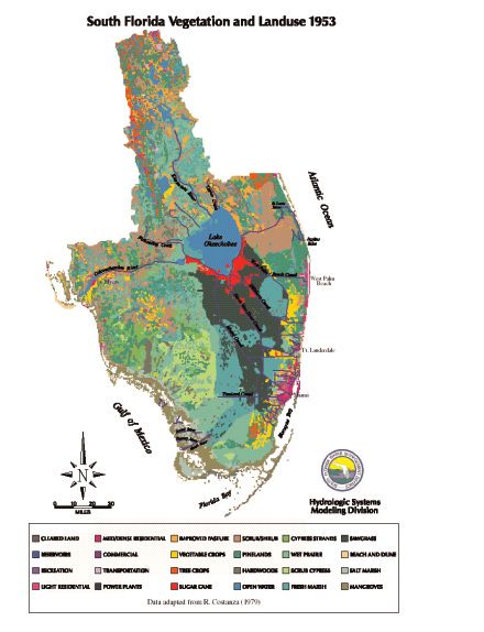
The South Florida Ecosystem encompasses 67,346 square
kilometers (26,002 square miles) covering the 19
southernmost counties in Florida (Figure 1). From a
watershed management perspective, South Florida can be
described by further subdividing the region into the
following subregions: Kissimmee River, Lake
Okeechobee, Lake Wales Ridge, Peace River/Charlotte
Harbor, Upper East Coast, Lower East Coast,
Caloosahatchee River, Everglades, Big Cypress, and
Florida Keys, including Biscayne Bay, Card Sound, and the
lower southwest estuaries (Figure 2).
Page 2-1
SOUTH FLORIDA ECOSYSTEM                     Multi-Species Recovery Plan for South Florida

Figure 2. Subregions and watersheds of the South Florida Ecosystem.

Page     2-2
SOUTH FLORIDA ECOSYSTEM Multi-Species Recovery Plan for South Florida
Kissimmee River
The Kissimmee River subregion forms the upstream portion of the Kissimmee-
Okeechobee-Everglades watershed. Originating near Orlando and ending at
Lake Okeechobee, the subregion encompasses most of Osceola and
Okeechobee counties as well as portions of Highlands, Polk, and Glades
counties. There are three sub-basins within the drainage: the upper basin, with
Lake Kissimmee and 18 smaller lakes; the lower basin with the Kissimmee
River and its tributary watersheds (excluding Istokpoga Creek) between Lake
Kissimmee and Lake Okeechobee; and the Lake Istokpoga drainage area (COE
1996, Koebel 1995). Lake Kissimmee is Floridas third largest lake, with a
surface area of 140 km² (54 mi2). Lake Istokpoga is the fifth largest in the State,
covering 112 km² (43 mi2) (Brenner et al. 1990). The drainage also includes the
Indian Prairie/Harney Pond sub-basin south of Lake Istokpoga and the Taylor
Creek/Nubbin Slough sub-basin, both of which are connected to Lake
Okeechobee by drainage canals.
Although relatively flat, the Kissimmee River drainage has greater
topographic relief than areas south of Lake Okeechobee. The western boundary
of the Kissimmee River subregion is clearly defined by the Lake Wales Ridge.
The eastern boundary is low and poorly defined, with elevations reaching up to
23 m (75 ft). The northeastern boundary is formed by the St. Johns River
drainage basin. Okeechobee and Osceola Plains are two broad physiographic
areas within this subregion.
The diversity of ecological community types in the Kissimmee River
subregion includes high pine on hilltops and slopes, scrub scattered throughout,
scrubby flatwoods on sandy coastal and interior sites, upland hardwood forests
on rolling hills, dry prairie inland, forested wetlands, marshes, lakes, and rivers
(blackwater streams).
Lake Okeechobee
Lake Okeechobee lies about 48 km (30 mi) west of the Atlantic Ocean and 96
km (60 mi) east of the Gulf of Mexico. Extending across parts of Highlands,
Charlotte, Glades, Hendry, Okeechobee, Martin, and Palm Beach counties, this
subregion covers the lake and its immediate drainage area to the west,
including Fisheating Creek. This subregion does not include the Kissimmee
River or Everglades drainages. Lake Okeechobee is the central feature of the
South Florida Ecosystem-its liquid heart. The lake is formed by a broad,
shallow, relatively circular depression in bedrock and has a surface area of
roughly 1,890 km2 (730 mi2) (COE 1994). Land levels around the lake vary
from 3 m (10 ft) to 15 m (50 ft) above sea level (McPherson and Halley 1997).
The lake is ringed with levees, pumping stations and control structures to
permit fluctuation of lake levels in response to drought, flood conditions and
water supply demands. Major outlets are the St. Lucie Canal to the east and the
Caloosahatchee Canal and River to the west. Also numerous agricultural canals
release excess lake water to Water Conservation Areas south of the lake.
Lake Okeechobee formed over 6,000 years ago. Originally, the water
flowed south and west from the lake. The lake was the source of the Everglades
Page 2-3SOUTH FLORIDA ECOSYSTEM Multi-Species Recovery Plan for South Florida
River of Grass sheetflow which sustained the Everglades and nourished
Florida Bay and coastal estuaries. During the last 50 years the Okeechobee
subregion has been re-engineered; resulting in a much shallower and nutrient-
laden lake, with a littoral zone filled with exotic species. Today, the major
vegetative communities outside the lake proper are predominantly freshwater
marsh with some cypress forest wetlands and small fragments of remnant pond
apple forest.
Lake Wales Ridge
The Lakes Wales Ridge subregion is a unique mosaic of elevated sandy ridges
encompassing an area from about the southern Highlands County boundary
160 km (99 mi) north to near Orlando. The Lake Wales Ridge averages about
7.5 km (4.6 mi) in width (Christman 1988). Though the name implies a single
physiographic area, the Lake Wales Ridge actually consists of three elevated,
sandy ridges that were once the beach and dune systems of Miocene, Pliocene
and early Pleistocene seas (Christman and Judd 1990). These relic dunes and
the deep, sandy, well-drained soils support a number of plant communities that
have adapted to xeric conditions over millions of years.
Due to the elevation and geologic age of the soils of Lake Wales Ridge
scrubs, it has been estimated that the highest hill tops in this area have
supported upland vegetation for about 25 million years. On the Lake Wales
Ridge, an estimated 200 ancient scrub islands have been identified (Christman
and Judd 1990). Between ridges and at the base of hills, the soils become fine
and compacted and often retain surface water, forming wetlands and lakes.
Rainfall, seepage, and elevated water tables provide the sources of water for
these aquatic systems. Combined with the aquatic and wetland communities
that now exist between and within the ridges, this subregion consists of a
complex mosaic of habitats, some unique to Florida.
Because of its complexity, the Lake Wales Ridge contains a wide diversity
of plant and animal communities. However, it is the xeric upland plant and
animal associations that constitute the majority of surface area. Although
relatively common within the Lake Wales Ridge, these xeric communities are
rare when compared to their relative distribution within the State and nation.
Several major ecological communities found within the Lake Wales Ridge
subregion provide important habitat for imperiled species. The most important
of those are scrub, high pine, scrubby flatwoods, lakes and freshwater marshes.
Peace River/Charlotte Harbor
The Peace River/Charlotte Harbor subregion encompasses about 7,800 km2
(3,012 mi2) in southwest Florida and includes the Myakka and Peace River
drainages. The Myakka River originates about 72 km (45 mi) inland in western
Manatee and eastern Hardee counties, while the Peace River begins about 115 km
(71 mi) from the coast in Polk and western Highlands counties (Taylor 1974).
Much of the Charlotte Harbor basin emerged from a shallow sea during the
Miocene and Pleistocene epochs. Only the immediate coastal areas remained
inundated until about one million years ago. Most of this area lies within the Gulf
Coast Lowlands or DeSoto Plains physiographic regions, both of which are
Page 2-4SOUTH FLORIDA ECOSYSTEM Multi-Species Recovery Plan for South Florida
composed primarily of marine sands and sediments (Southwest Florida Regional
Planning Council 1995). These soils are all deep, nearly flat, and poorly drained.
Northern portions of the Charlotte Harbor subregion, primarily within the
Peace River drainage, are characterized by cypress and hardwood hammocks and
extensive areas of poorly drained marshes. Central and southern areas include
marsh, dry and wet prairies, pine flatwoods, and estuaries (DEP 1995). Mesic
flatwoods support a wide diversity of animals and represent the third highest
species richness of vegetative communities in Florida (Beever and Dryden 1998).
Dry prairie is one of the most widespread upland vegetative communities in the
Charlotte Harbor basin. Coastal areas, including Charlotte Harbor proper, contain
expanses of seagrass beds, mangrove, and coastal strand communities. There are
roughly 23,675 ha (58,500 acres) of seagrass in Charlotte Harbor (CHNEP 1996);
this community provides important ecological functions that benefit many
threatened and endangered species as well as migratory birds. Mangroves provide
a variety of habitats and food resources for a diversity of animals, serve to hold
and stabilize intertidal sediments, and provide erosion protection for adjacent
uplands.
Upper East Coast
The Upper East Coast subregion, which includes Indian River, St. Lucie, and
Martin counties and a northern portion of Palm Beach County, covers over
5,631 km2 (2,174 mi2) and has an average elevation of 6 m (20 ft). Formed by
the rise and fall of changing sea levels, the region is characterized by three east-
to-west physiographic zones: (1) the Atlantic Coastal Ridge, (2) the Eastern
Valley, and (3) the Osceola Plain (SFWMD 1994). The Atlantic Coastal Ridge,
bordered on the east by the Atlantic Ocean and on the west by the Eastern
Valley, consists of relic dune ridges formed by wind and wave action along the
coastline. Paralleling the east coast, the Ridge varies in width from a few
hundred meters to a few kilometers and ranges in elevation from sea level to
28 m (92 ft) in Jonathan Dickinson SP, the highest coastal elevation in this
subregion.
A wide variety of upland vegetative communities exist throughout the
subregion, including coastal dunes, coastal strand, maritime forest, scrub,
hardwood hammock, and pine flatwoods. Wetland habitats are a vital
component for the biodiversity of the region. Between the barrier islands and
the coastal ridge (or mainland) lies the Indian River Lagoon, a linear estuarine
system that extends along more than a third of Floridas east coast. Numerous
freshwater wetlands and sloughs undergo a transition into riverine systems that
connect directly to the Indian River Lagoon. The combination of freshwater
and saltwater wetlands, seagrass and mangrove communities in particular,
contribute valuable cover, foraging areas, and reproductive habitats for many
fish and wildlife species in this subregion.
Lower East Coast
The Lower East Coast subregion extends approximately 160 km (99 mi) north
to south through large coastal portions of Palm Beach, Broward, and Miami-
Dade counties. The major topographic feature of the Lower East Coast
Page 2-5SOUTH FLORIDA ECOSYSTEM Multi-Species Recovery Plan for South Florida
subregion is the Atlantic Coastal Ridge. This limestone ridge extends the length
of the Atlantic Coast. Three major estuaries and marine systems occur in this
subregion: Lake Worth Lagoon in Palm Beach County, Biscayne Bay in
Miami-Dade County, and West Lake in Broward County.
The Lower East Coast subregion is the most highly urbanized area in
Florida, containing 30 percent of the States residents. Most urbanization
occurs along the coastal portion of the subregion with substantial agriculture
present south and west of the Atlantic Coastal Ridge (Science Subgroup 1996).
Although the region is highly urbanized, many species of native fauna and
flora continue to exist in the remnant patches of native vegetative communities.
Ecological communities found in this subregion include beach dune, coastal
strand, maritime and tropical hardwood hammocks, pine rocklands, scrub, pine
flatwoods, mangrove swamps, coastal saltmarsh, freshwater marsh, and wet
prairie (Myers and Ewel 1990, Science Subgroup 1996).
Water resources for this subregion are primarily available from rainfall and
surface and groundwater storage systems such as shallow surficial aquifers.
The area between Boynton Beach and Miami receives the highest amount of
rainfall in the State (163 cm or 64 in). The Biscayne Aquifer is the largest of
its kind, and one of the most important natural resources in the area. It extends
throughout Miami-Dade County, into a majority of Broward County, and a
portion of southern Palm Beach County. Public water for the Florida Keys,
Broward County, and Miami-Dade County is supplied by the Biscayne Aquifer.
This aquifer also depends on rainfall for recharge (Southwest Florida Regional
Planning Council 1995, Science Subgroup 1996).
Caloosahatchee River
The Caloosahatchee River subregion encompasses the Caloosahatchee River
watershed, the lower Charlotte Harbor estuarine system, including San Carlos
Bay, Matlacha Pass (south of an east-west line from Boca Grand Inlet), and
Pine Island Sound, the Estero Bay estuary and watershed, and the Immokalee
Rise. This area is approximately 516,000 ha (1.28 million acres), and includes
most of Lee County, the southeastern portion of Charlotte County, western
Hendry County, and southern Glades County. The major physiographic
provinces of the subregion are the Caloosahatchee Valley, Gulf Coast
Lowlands, DeSoto Plain and the Immokalee Rise (Southwest Florida Regional
Planning Council 1995). Within this subregion, the Immokalee Rise includes
most of Hendry County and eastern Lee County. It is about 8 m (25 ft) in
elevation, but can peak at 11 m (36 ft) and 13 m (43 ft) in some areas. All soils
are deep, nearly level, and poorly drained, with a water table less than 25 cm
(10 in) from the surface during at least part of the year (SWFRPC 1995).
Historically, the Caloosahatchee River was a shallow, meandering 80 km
(50 mi) long system, with headwaters near Lake Hicpochee (Science Subgroup
1996). Today, however, it extends approximately 114 km (71 mi) from Lake
Okeechobee to San Carlos Bay, as a channelized flood control and navigational
waterway. The river is supplied by inflows from Lake Okeechobee and runoff
within its own basin. It was extended to Lake Okeechobee by dredging in 1884,
and was subsequently channelized to improve navigation and flood control.
Page 2-6SOUTH FLORIDA ECOSYSTEM Multi-Species Recovery Plan for South Florida
The river now has three locks or water control structures: Moore Haven Lock,
Ortona Lock, and Franklin Lock. The freshwater portion of the river, also
called the C-43 Canal, extends eastward from the Franklin Lock and Dam
toward Lake Okeechobee and the cities of LaBelle and Moore Haven. The C-
43 Canal is part of the cross-state Lake Okeechobee Waterway that provides
navigation between the east and west coasts of Florida. West of the Franklin
Lock, from Olga to the Gulf, the river broadens into a tidally influenced
estuarine system. Franklin Lock, also called S-79, serves as a salinity barrier to
tidal changes and as a conveyor of freshwater into the estuary (COE 1994).
The estuarine portion of the Caloosahatchee Subregion is approximately
42 km (26 mi) long and extends from S-79 to Shell Point where it discharges
into San Carlos Bay at the southern end of Charlotte Harbor (COE 1994). The
average discharge is 2,000 cubic feet/second (cfs) (Science Subgroup 1996).
San Carlos Bay connects the mouth of the Caloosahatchee River to Matlacha
Pass and Pine Island Sound (COE 1994). The Caloosahatchee River can
discharge freshwater to the southern portion of Pine Island Sound during
periods of large releases from Lake Okeechobee, but the primary source of
freshwater is sheetflow from the surrounding islands, as well as from the small
creeks and marshes on Pine island, and the Sanibel River on Sanibel Island
(CHNEP 1996).
The Estero Bay estuary and watershed in southwestern Lee County,
consists of Estero Bay and associated barrier islands, the Estero Bay basin,
including the Imperial and Estero rivers, and the Six-Mile Cypress Slough
Watershed (Science Subgroup 1996). Estero Bay is a shallow, subtropical
estuarine lagoon, approximately 4,580 ha (11,317 acres) in area. Five creeks
and rivers drain into the bay including Hendry Creek, Mullock Creek, Estero
River, Spring Creek, and Imperial River. The Six-Mile Cypress Slough, in
central Lee County, (830 ha or 2,051 acres) is an important recharge area for
the watershed. Estero Bay is separated from the Gulf of Mexico by several
barrier islands: Estero Island, the Lovers Key complex (Long Key, Lovers Key,
Black Island), Big Hickory Island, Little Hickory Island, and Bonita Beach
Island (CHNEP 1996). Estero Bay was designated a State Aquatic Preserve and
its tributary watersheds are protected by the State of Florida.
Predominant ecological communities in this subregion, in addition to the
Caloosahatchee River, proper, include pine flatwoods, scrubby flatwoods,
coastal strand, freshwater marshes, mangroves, and seagrasses.
Everglades
The Florida Everglades is unique in the world, combining both temperate and
tropical flora in a widely shifting mosaic of habitats. Historically, water
connected the entire Kissimmee River-Lake Okeechobee-Everglades
watershed. The system was bordered on the east by the Atlantic Coastal Ridge
and on the west by the Immokalee Rise (McPherson and Halley 1997). Prior to
drainage of this system of wetlands by man, the Everglades region consisted of
dense, seemingly impenetrable wetlands, extending over an area
approximately 64 km (40 mi) wide by 160 km (99 mi) long (Brooks 1974,
Davis 1943, Parker 1974, Tebeau 1974) and covering an estimated 3.5 million
Page 2-7SOUTH FLORIDA ECOSYSTEM Multi-Species Recovery Plan for South Florida
ha (8.6 million acres) (COE 1994). Today, much of the land that historically
supported Everglades communities now supports a variety of land uses,
ranging from intensively managed agriculture in the north (EAA), to rapidly
spreading urban uses along the east and west boundaries.
Geologically, the Everglades system is young, formed 5,000 years ago as
rising sea levels created pressure to contain freshwater within the shallow
bedrock trough in South Florida, and allowed the accumulation of thick peat in
deep areas (Gleason and Stone 1994). During the dry season and during periods
of below-average precipitation, the Everglades subsists on nutrients derived
primarily from the atmosphere through rainfall (Lodge 1994). The system is
not directly fed by streams or rivers, but, is balanced through precipitation,
evapotranspiration, and subsurface movement into and out of the aquifer
(Wagner and Rosendahl 1987). It is this characteristic that gives rise to the
uniqueness of the Everglades and its recognition as a system dependent on
sheetflow. In contrast, most of the worlds other large wetland systems that on
some level resemble the Everglades, such as the Pantanal of Brazil, the Llanos
of Venezuela, and the Usumacinta and Grijalva river deltas of Mexico, receive
their nutrients and water from rivers that overflow their banks (Lodge 1994).
The Everglades subregion consists of a complex system of hydrologically
inter-related landscapes. Because the Everglades is located on a peninsula that
extends from a temperate to a subtropical climate, the associated flora consists
of tropical, temperate, and endemic species (Gunderson 1994). Gunderson
(1994) grouped Everglades communities into upland and wetland vegetative
components based on hydro-edaphic conditions, water chemistry, and
vegetative growth form. Everglades uplands are composed of rockland
communities, which include rockland pine forests and tropical hardwood
hammocks. Everglades freshwater wetland communities are categorized as
forested wetlands, marshes, prairies, and ponds and sloughs. The periphyton
community, composed of many taxa of microalgae, occurs in concert with
many of the freshwater communities in the Everglades, and is an important
element of the base of the food chain.
Big Cypress
The Big Cypress subregion includes all of Collier and portions of Lee, Hendry,
and Monroe counties. This subregion has two watersheds: the Corkscrew
Swamp from near Lake Trafford and southwest to the coast, and the Big
Cypress Swamp running southwest and perpendicular to the Tamiami Canal.
The South Florida Shelf runs through the subregion and generally parallels the
southwest coast. The landscape is relatively flat and underlain with an uneven
bedrock surface which is usually covered by a veneer of soils. The soils are
relatively modern and in the process of formation from surficial sediments such
as sand and calcareous marl mixing with organic peat and muck components.
The more than 320,000 ha (790,720 acres) of connected wetlands feature
the Corkscrew Regional Ecosystem Watershed, Corkscrew Swamp, Camp
Keais Strand, Okaloacoochee Slough, Fakahatchee and Picayune strands, Belle
Meade, and a major portion of Big Cypress National Preserve. The system
encompasses mostly cypress, pine, and hardwood forests, as well as prairies
Page 2-8SOUTH FLORIDA ECOSYSTEM Multi-Species Recovery Plan for South Florida
and sloughs that drain into the Ten Thousand Islands and Rookery Bay
estuarine systems and into other estuaries off the Everglades. Major ecological
communities of the Big Cypress subregion include pinelands, hammocks,
beach dune, coastal strand, prairies, cypress swamps, mangroves, and
freshwater and saltwater marshes.
Florida Keys, including Biscayne Bay, Card Sound, and the Lower
Southwest Estuaries
This subregion is geographically within Monroe County and a portion of Miami-
Dade County. It covers the estuarine waters contiguous with Florida Bay and the
Florida Keys. Biscayne Bay is at the southeast corner of the State, protected from
the deeper waters of the Florida Straits and the Atlantic Ocean by the northern
extent of the Florida Keys. Card Sound lies off the northern Keys. Florida Bay
and Ponce de Leon Bay are located around the tip of the State up the southwest
coastline.
This unique subregion began forming 100,000 years ago when the sea level
was 8 m (26 ft) above the present level. Along a submerged platform, coral reefs
developed in a band from present-day Miami to the Dry Tortugas. Fossil
remnants of reef organisms form the exposed limestone bedrock of todays
Middle and Upper Keys. What has evolved is a combination of marine and
tropical upland habitats that support a wealth of biological diversity and habitats,
some found nowhere else in the world. Because of the geographic isolation of the
Keys, there are numerous endemic plants and animals. The natural community
types of primary importance in the Keys and lower Florida coast include
hardwood hammocks, pine rocklands, freshwater wetlands, mangrove wetlands,
seagrasses and coral reefs.
West Indian hardwood hammocks and pine rocklands are imperiled upland
communities of the Florida Keys. Of approximately 3,359 ha (8,300 acres) of
Keys hardwood hammock, over 3,035 ha (7,500 acres) are unprotected. There are
more than 120 species of hardwood trees, shrubs, and plants that grow in these
unique, dense uplands. Only about 404 ha (998 acres) of an estimated 910 ha
(2,249 acres) of pine rocklands are protected. Shoreline habitats, such as
mangrove wetlands, transitional wetlands, and beach habitats are also found in
this region. These habitats are all critical nursery areas for aquatic life and shelter
the coasts from erosion.
The mangrove forest ecosystem along the shoreline of this subregion provides
food and shelter to a myriad of marine organisms and shelter for diverse avian life.
Biscayne Bay has the longest stretch of mangrove shoreline left on the east coast
of the U.S. The shallow protected waters of the estuaries support clear waters and
lush seagrass beds that serve as an important nursery for marine life, providing
food and shelter to larvae and juveniles. Mangrove communities provide nursery
areas for many fish.
The Florida Keys coral reef tract is one of the worlds major barrier reefs, the
most extensive living coral reef system in North America and the third largest reef
system on the planet. It extends the length of the Keys, from Biscayne Bay to the
Page 2-9SOUTH FLORIDA ECOSYSTEM Multi-Species Recovery Plan for South Florida
Dry Tortugas, almost 322 km (200 mi) of subtropical islands surrounded by the
Gulf of Mexico and Florida Bay to the west and Atlantic Ocean to the southeast.
The Biogeography of South Florida
A unique combination of history, climate, geography, and environmental forces
has made the South Florida Ecosystem an important reservoir of landscape,
community, and species diversity. The fauna of this region is extremely young
and dynamic, and understanding it requires abandoning simple explanations
due to historical zoogeography, ecological conditions, hydrological conditions,
or human disturbance alone. Three factors mostly define the nature of southern
Floridas biodiversity: the recent origin of freshwater and terrestrial
ecosystems; peninsula geography and habitat diversity; and subtropical
wet/dry climate and productivity.
The climate in South Florida is subtropical and humid with average annual
temperatures in the mid-20s C (70s F), ranging from about 16 C (60 F) in
midwinter to about 27 C (80 F) in summer. Rainfall averages about 137 cm (54
in), with 50 to 60 percent of it from June to September. High rainfall may also
occur during late summer and early fall in association with tropical storms or
hurricanes. Hurricane season extends from June 1 through November 30.
The ecological communities of South Florida were not established until
about mid-Holocene, but this relatively short time allowed the differentiation
of distinctive phenotypes and genotypes (Webb 1990). Layne (1984) suggested
that much of South Floridas subspeciation is a product of isolation and
changing conditions. There is a general pattern of reduced species richness as
one proceeds down the Florida peninsula. This has been discussed as a
peninsula effect due to reduced land area, decreased rates of invasion, and/or
increased rates of extinction (e.g., Cook 1969, Duellman and Schwartz 1958,
Kiester 1971, MacArthur and Wilson 1967, Robertson 1955, Simpson, 1964).
Reduced species numbers and stressful conditions are not equally expressed in
all ecological or taxonomic segments, however. Layne (1984) listed 32 species
of native mammals (including bats) in mainland Florida south of Lake
Okeechobee, as compared with 51 species for the State as a whole. Carnivores
comprise a larger proportion of the mammalian fauna in southern Florida than
in the rest of the State (31 percent vs. 20 percent). Robertson and Kushlan
(1984) listed 296 species of birds regularly seen in South Florida, over 60
percent of which are migratory. These authors noted wading bird densities and
species richness in South Florida that was historically as high as anywhere in
North America, and they point out that the nearly unique ability of the South
Florida ecosystem to support such large numbers of 14 species of superficially
similar secondary and tertiary consumers on a resource base that is reduced in
species diversity by biogeographic factors is generally unappreciated. Busack
and Hedges (1984) and Dalrymple et al. (1991) have noted no reduced species
diversity for lizards and snakes in their studies, and Dalrymple (1988) noted
high numbers for some amphibian and reptile species in South Florida. Of the
132 species of amphibians and reptiles known from Florida, 72 species are
known from South Florida (55 percent) (Dalrymple 1988). Loftus and Kushlan
(1987) found 92 freshwater fish species in South Florida. In addition, some 217
Page 2-10SOUTH FLORIDA ECOSYSTEM Multi-Species Recovery Plan for South Florida
fish species have been collected from various marine and estuarine mangrove
communities of South Florida. Over 600 species of fish have been noted from
the Indian River Lagoon region (Indian River Lagoon National Estuary
Program 1996). A total of 246 fish species have been reported from the
estuarine ecosystem of Charlotte Harbor, including 18 commercially important
species and 5 species that are important for recreational fisheries (Taylor 1974).
The Species of Concern
Threatened and Endangered Species
There are 68 federally listed species that occur in South Florida (Table 1). Note
that this number does not include the mountain lion, peregrine falcon, or
American alligator, which are listed by similarity of appearance, the whooping
crane, which is considered an experimental population, or cetaceans or Johnsons
seagrass which NMFS has the recovery lead for. Information on the biology,
ecology, status, trends, management, and needed recovery actions for each of the
68 species are included in The Species section of this Recovery Plan. The
ecological community accounts in The Ecosystem section highlight a few of
the other species of concern occurring in the South Florida Ecosystem; a
comprehensive list of these species by community type is given in Appendix C.
Migratory Birds
The South Florida Ecosystem is located along one of the primary migratory
routes for bird species that breed in temperate North America and winter in the
tropics of the Caribbean and South America. Many species of neotropical
migrants have been recorded in the South Florida Ecosystem (Appendix D). In
1995, the FWS prepared a list of migratory nongame birds of management
concern in the U.S. to stimulate a coordinated effort by Federal, State, and
private agencies to develop and implement comprehensive and integrated
approaches for the management of these selected species (FWS 1995). The
South Florida Ecosystem supports 43 of these species (Table 2). Large numbers
of species like the bobolink (Dolichonyx oryzivorus), a species of management
concern, migrate through the South Florida Ecosystem as they fly from their
breeding grounds in southern Canada and the northern Great Plains on their
way to the marshes of Argentina and Brazil. Virtually the entire North
American population of blackpoll warblers (Dendroica striata) migrates to
South America along a route that passes through Florida to the West Indies.
Other migratory species like the tanagers (Pirange spp.), chimney swifts
(Chaetura pelagica), tree swallows (Iridoprocne bicolor), nighthawks
(Chordeiles minor), royal terns (Sterna maxima), and blue-winged teal (Anas
discors) also have major migratory pathways through the South Florida
Ecosystem.
More than 129 bird species migrate to the South Florida Ecosystem to
overwinter. Another 132 bird species breed in the South Florida Ecosystem.
Because the South Florida Ecosystem is located near Cuba and the West Indies,
it draws Caribbean species that rarely appear elsewhere in North America.
Page 2-11SOUTH FLORIDA ECOSYSTEM Multi-Species Recovery Plan for South Florida Table 1. Federally listed endangered and threatened species in South Florida. Mammals (except whales) Florida panther Puma concolor coryi E Mountain lion Puma concolor T (S/A) Key deer Odocoileus virginianus clavium E Key Largo cotton mouse Peromyscus gossypinus allapaticola E Key Largo woodrat Neotoma floridana smalli E Lower Keys rabbit Sylvilagus palustris hefneri E Rice rat (= silver rice rat) Oryzomys palustris natator (= O. argentatus) E (CH) Southeastern beach mouse Peromyscus polionotus niveiventris T West Indian manatee Trichechus manatus E (CH) Birds Audubons crested caracara Polyborus plancus audubonii T Bachmans warbler Vermivora bachmanii E Bald eagle Haliaeetus leucocephalus T Cape Sable seaside sparrow Ammodramus (=Ammospiza) maritimus mirabilis E (CH) Everglade snail kite Rostrhamus sociabilis plumbeus E (CH) Florida grasshopper sparrow Ammodramus savannarum floridanus E Florida scrub-jay Aphelocoma coerulescens T Ivory-billed woodpecker Campephilus principalis E Kirtlands warbler Dendroica kirtlandii E Peregrine falcon Falco peregrinus E (S/A) Piping plover Charadrius melodus T Red-cockaded woodpecker Picoides (= Dendrocopos) borealis E Roseate tern Sterna dougallii dougallii T Whooping crane Grus americana XN Wood stork Mycteria americana E Reptiles American crocodile Crocodylus acutus E (CH) American alligator Alligator mississippiensis T (S/A) Page 2-12
SOUTH FLORIDA ECOSYSTEM Multi-Species Recovery Plan for South Florida
Table 1. cont.
Atlantic salt marsh snake Nerodia clarkii (=fasciata) taeniata T
Bluetail (=blue-tailed) mole skink Eumeces egregius lividus T
Eastern indigo snake Drymarchon corais couperi T
Green sea turtle Chelonia mydas (incl. agassizi) E (CH)
Hawksbill sea turtle Eretmochelys imbricata E (CH)
Kemps (=Atlantic) ridley sea turtle Lepidochelys kempii E
Leatherback sea turtle Dermochelys coriacea E (CH)
Loggerhead sea turtle Caretta caretta T
Sand skink Neoseps reynoldsi T
Invertebrates
Schaus swallowtail butterfly Heraclides (= Papilio) aristodemus ponceanus E
Stock Island tree snail Orthalicus reses (not incl. nesodryas) T
Plants
Avon Park harebells Crotalaria avonensis E
Beach jacquemontia Jacquemontia reclinata E
Beautiful pawpaw Deeringothamnus pulchellus E
Brittons beargrass Nolina brittoniana E
Carters mustard Warea carteri E
Crenulate lead-plant Amorpha crenulata E
Deltoid spurge Chamaesyce(=Euphorbia) deltoidea spp. deltoidea E
Florida bonamia Bonamia grandiflora T
Florida golden aster Chrysopsis (=Heterotheca) floridana E
Florida perforate cladonia Cladonia perforata E
Florida ziziphus Ziziphus celata E
Four-petal pawpaw Asimina tetramera E
Fragrant prickly-apple Cereus eriophorus var. fragrans E
Garbers spurge Chamaesyce(=Euphorbia) garberi T
Garretts mint Dicerandra christmanii E
Highlands scrub hypericum Hypericum cumulicola E
Page 2-13SOUTH FLORIDA ECOSYSTEM Multi-Species Recovery Plan for South Florida Table 1. cont. Key tree-cactus Pilosocereus (= Cereus) robinii E Lakelas mint Dicerandra immaculata E Lewtons polygala Polygala lewtonii E Okeechobee gourd Cucurbita okeechobeensis spp. okeechobeensis E Papery whitlow-wort Paronychia chartacea (= Nyachia pulvinata) T Pigeon wings Clitoria fragrans T Pygmy fringe-tree Chionanthus pygmaeus E Sandlace Polygonella myriophylla E Scrub blazing star Liatris ohlingerae E Scrub buckwheat Eriogonum longifolium var. gnaphalifolium T Scrub lupine Lupinus aridorum E Scrub mint Dicerandra frutescens E Scrub plum Prunus geniculata E Short-leaved rosemary Conradina brevifolia E Smalls milkpea Galactia smallii E Snakeroot Eryngium cuneifolium E Tiny polygala Polygala smallii E Wide-leaf warea Warea amplexifolia E Wireweed Polygonella basiramia (= ciliata var. b.) E Page 2-14
SOUTH FLORIDA ECOSYSTEM                             Multi-Species Recovery Plan for South Florida

                      Examples of these species include the smooth-billed ani (Crotophaga ani),
                      mangrove cuckoo (Coccyzus minor), Antillean night hawk (Chordeiles
                      gundlachii), white-crowned pigeon (Columba leucocephala), and black-
                      whiskered vireo (Vireo altiloquus).
                           The South Florida Ecosystem has an endemic race of the yellow warbler
                      (Dendroica petechia) and contains the majority of the nesting locations for the
                      great white heron (Ardea herodias occidentalis), reddish egret (Egretta
                      rufescens), roseate spoonbill (Ajaia ajaja), swallow-tailed kite (Elanoides
                      forficatus), and short-tailed hawk (Buteo brachyurus) in the U.S.
                           Fifteen species of herons, storks, and ibises nest in the South Florida Eco-
                      system and are considered ecological indicators because of their wide foraging
                      ranges, relatively narrow food requirements, and relatively specific habitat
                      requirements. Their breeding success reflects the health of the wetland and
                      coastal habitats of the South Florida Ecosystem. Wading bird populations in the
                      South Florida Ecosystem have undergone declines far greater than the declines
                      of their nesting habitats. According to current estimates, breeding populations of
                      wading birds in South Florida have declined by more than 90 percent as their
                      habitats have been reduced by 50 percent (Ogden 1994). Of the 15 species of
                      wading birds that breed in the South Florida Ecosystem, the wood stork
                      (Mycteria americana), great egret (Casmerodius albus), snowy egret (Egretta
                      thula), tricolored heron (Hydranassa tricolor), and white ibis (Eudocimus albus)
                      have declined by an estimated 75 to 80 percent between the 1930s and the late
                      1970s. The wood stork has undergone the most serious population decline
                      (Ogden 1994). Habitat destruction and loss have reduced the supply of fish and
                      other food items, thus contributing to the overall decline of wading birds.
                           The coastal area of the South Florida Ecosystem, like the rest of Florida,
                      provides important breeding and wintering areas for shorebirds. The beaches
                      provide nesting habitat for 13 species of shorebirds and support one of the two
                      largest concentrations of wintering shorebirds in Florida. The South Florida
                      Ecosystem also contains important wintering habitat, including portions of the
                      Key West National Wildlife Refuge (NWR), for the endangered piping plover
                      (Charadrius melodus).
                           Land conversion for residential housing has significantly reduced the
                      amount and quality of nesting and wintering habitat for migratory birds in the
                      South Florida Ecosystem. Very few bird habitats in South Florida have been
                      protected from the effects of this land conversion. Although the response of
                      breeding and wintering populations of migratory birds to habitat losses in
                      South Florida is uncertain, the magnitude of the habitat loss is certain to
                      adversely affect migratory bird species. For example, Charlotte Harbor once
                      supported large numbers of nesting black skimmers (Rynchops niger), snowy
                      plovers (Charadrius alexandrinus), American oystercatchers (Haematopus
                      palliatus), royal terns, and sandwich terns (Sterna sandvicensis). Because of
                      habitat loss in Charlotte Harbor, these species now concentrate along the coast
                      of the Panhandle and the northeast coast of Florida. (Cox et al. 1994).

                                                                                     Page         2-15
SOUTH FLORIDA ECOSYSTEM Multi-Species Recovery Plan for South Florida
Table 2. Migratory nongame birds of management concern in the South Florida
Ecosystem.
American bittern Botaurus lentiginosus* loggerhead shrike Lanius ludovicianus*
American swallow-tailed kite Elanoides forficatus long-billed curlew Numenius americanus
Bachman's sparrow Aimophila aestivalis* Louisiana waterthrush Seiurus motacilla
barn owl Tyto alba* northern harrier Circus cyaneus*
black rail Laterallus jamaicensis northern flicker Colaptes auratus
black-capped petrel Pterodroma hasitata painted bunting Passerina ciris
black-throated blue warbler Dendroica co erulescens prairie warbler Dendroica discolor
black-whiskered vireo Vireo altiloquus reddish egret Egretta rufescens*
blue-winged warbler Vermivora pinus seaside sparrow Ammodramus maritimus*+
bobolink Dolichonyx oryzivorus sedge wren Cistothorus platensis
brown pelican Pelecanus occidentalis+ short-tailed hawk Buteo brachyurus
burrowing owl Speotyto cunicularia snowy plover Charadrius alexandrinus*
common loon Gavia immer* Swainson's warbler Limnothlypis swainsonii
common ground-dove Columbina passerina upland sandpiper Bartramia longicauda
eastern meadowlark Sturnella magna veery Catharus fuscescens
field sparrow Spizella pusilla white-crowned pigeon Columba leucocephala
grasshopper sparrow Ammodramus savannarum+ Wilson's plover Charadrius wilsonia
Henslow's sparrow Ammodramus henslowii* wood thrush Hylocichla mustelina
lark sparrow Chondestes grammacus worm-eating warbler Helmitheros vermivorus
least bittern Lxobrychus exilis* yellow rail Coturnicops noveboracensis
least tern Sterna antillarum yellow-billed cuckoo Coccyzus americanus
limpkin Aramus guarauna
* = also on the FWS 1987 list of management concern.
+ = Florida population of brown pelican was removed from the list of threatened species on March 6, 1985 (Federal
Register 50(23), February 4, 1985, pp 4,938-4,945).
+ = Florida grasshopper sparrow (Ammodramus savannarum floridanus) was listed as endangered in July 1986
(Federal Register, July 31, 1986).
+ = Cape Sable seaside sparrow (Ammodramus maritimus mirabilis) was listed as endangered in March 1967 (Federal
Register, March 11, 1967), and critical habitat designated in August 1977.
+ = Dusky seaside sparrow (Ammodramus maritimus nigrescens) was removed from the endangered list as extinct on
January 11, 1991 (Federal Register 55(239), December 12, 1990, pp 51,112-51,114).
Page 2-16SOUTH FLORIDA ECOSYSTEM Multi-Species Recovery Plan for South Florida
Interjurisdictional Fish
Estuarine and marine fish are integral to the ecology and economy of South
Florida, reflecting, to a large extent, the health of aquatic systems and the
ecosystem as a whole. For example, Florida Bay fish populations are critical to
the health of the wading bird colonies along the northern edge of the Bay. Also,
anglers spend millions of dollars annually fishing in Florida for such species as
red drum (Sciaenops ocellatus), spotted seatrout (Cynoscion nebulosus), tarpon
(Megalops atlanticus), snook (Centropomus sp.), bonefish (Albula vulpes),
jacks (Caranx sp.), snappers (Lutjanus sp.), groupers (Epinephelus sp.), sharks
(30 to 40 species), spiny lobsters (Panulirus argus), and stone crabs (Menippe
mercenaria). To further highlight the importance of such species to humans and
the relevance of the South Florida Ecosystem to fish, consider that more than
one-third of the fish and shellfish landed in Floridas coastal waters were
caught by vessels originating from South Florida ports. In 1997, these vessels
landed more than 19 million lbs (8.6 million kg) of fish and 18.9 million lbs
(8.6 million kg) of shellfish. This catch was valued at $88.5 million (Josh
Bennett, NOAA Southeastern Fisheries Science Center, personal
communication 1999).
An estimated 96 percent (98 percent Gulf of Mexico and 94 percent
southeast Atlantic) by weight of commercially and recreationally important
marine fish species in South Florida are dependent upon estuarine habitats for
critical life processes (Chambers 1991). The coastal, estuarine, and nearshore
ecosystems of South Florida provide a nursery for a wide variety of fish and
shellfish species, supporting offshore fisheries in the South Atlantic and Gulf
of Mexico. Florida Bay is a key nursery area for various marine species
including spotted seatrout, bonefish, red drum, tarpon, pink shrimp (Penaeus
duorarum), and spiny lobster. Also, Charlotte Harbor is the southern range of
the threatened Gulf sturgeon (Acipenser oxyrhinchus desotoi). The status of
Gulf sturgeon in Charlotte Harbor is unclear; however, information indicates
that juvenile sturgeon have been collected by commercial fishermen in the
1990s (F. Parauka, FWS, personal communication 1996).
The habitats that historically supported South Florida fish populations have
declined significantly in area and quality over the past 50 years. The alteration
of freshwater flows to the estuaries along the southern and southwestern coasts
of Florida has reduced water quality of the estuarine habitats of the region. A
90 percent reduction in freshwater inflow and increased levels of nutrient and
pesticides have contributed to an increase of algal blooms, lost seagrass beds,
sponge mortality, and salinity increases. Excessive pulses of fresh water
released into the estuaries over a short time frame are also very harmful. The
resulting decrease in salinity, increase in suspended solids, and other water
chemistry parameter changes can severely stress or kill estuarine organisms.
All of these changes have caused increased incidences of fish kills and
serious losses of mangroves-all of which are directly linked to land use or land
misuse in areas surrounding the Everglades as well as to South Floridas water
management regime.
Page 2-17SOUTH FLORIDA ECOSYSTEM Multi-Species Recovery Plan for South Florida
An April 1996 workshop, Identification of Potentially Endangered
Species in the Gulf of Mexico and Determination of Research Needs for These
Species, held at the Gulf Coast Research Laboratory in Ocean Springs,
Mississippi, identified the following species of concern within the contiguous
areas of the South Florida Ecosystem: opossum pipefish (Microphis
brachyurus lineatus), mangrove rivulus (Rivulus marmoratus), mangrove
gambusia (Gambusia phizophorae), blue croaker (Bairdiella batabana), sea
lamprey (Petromyzon marinus), striped bass (Morone saxatilis), key silverside
(Menidia conchorum), small tooth sawfish (Pristis pectinata), and some
sharks. Many of these species are tropical peripherals, following the Gulf
Stream and other currents into the South Florida area. The opossum pipefish
and many gobies (Gobionellus sp.) depend on oligohaline areas (e.g., the
mouth of the St. Lucie River) for reproduction, although opossum pipefish
have been found in Lake Okeechobee (R. Gilmore, Harbor Branch
Oceanographic Institute, personal communication 1996). These species are
especially sensitive to blockages in rivers, such as dikes, dams, or weirs, that
impede their movements; and they also are flushed out by instantaneous and
unramped water releases. Many vegetative species targeted for herbiciding,
such as panicum grass, are used by these species. Although their ecosystem
roles are not fully understood or appreciated, the fact that they are diminishing
signals other system imbalances.
Freshwater fish may not be faring any better than marine and estuarine
species. Human health advisories are in place due to the mercury content of
such fish as largemouth bass (Micropterus salmoides), bowfin (Amia calva),
gar (Lepisosteus sp.), spotted sunfish (Lepomis punctatus), Mayan cichlid
(Cichlasoma urophthalmus), warmouth (Lepomis gulosus), and yellow
bullhead catfish (Ictalurus natalis) in approximately 12 rivers and 17 lakes in
South Florida, as well as in the Savannas Marsh, Big Cypress Preserve, Arthur
R. Marshall Loxahatchee NWR, Everglades Water Conservation Areas 2a and
3, and Everglades NP (Florida Department of Health and Rehabilitative
Services 1993).
Status and Trends
The natural resource issues in South Florida are extremely complex. Human
socioeconomics and demographics play a major role in the process of species
recovery and habitat restoration. A majority of imperiled species in this region
are habitat-limited. With an increasing human population, habitat loss,
fragmentation and degradation are critical issues to overcome to effect
recovery.
Human Population Trends in South Florida
Just before the turn of the 20th century, the total population of the 16 counties
now included in the South Florida Water Management District was 32,000
people. Nearly 20,000 of those people lived in Key West. Only 861 people
lived in the area currently occupied by Miami, Fort Lauderdale, and West Palm
Beach (Intragency Working Group 1994).
Page 2-18SOUTH FLORIDA ECOSYSTEM Multi-Species Recovery Plan for South Florida
Ninety years later, that situation has changed dramatically. Half of
Floridas 12 million people currently live in the South Florida Ecosystem: one
out of every four of Floridas population lives in Miami-Dade and Broward
counties. The South Florida Ecosystem contains four of the top ten fastest-
growing metropolitan statistical areas in the United States: including Naples,
Fort Pierce, Fort Myers-Cape Coral, and West Palm Beach-Boca Raton-Delray
Beach (the first, third, fourth, and sixth fastest-growing areas in the country,
respectively).
Floridas population, fourth largest in the U.S., is expected to reach 17.8
million (331 per mi2) by 2010 (Floyd 1997a). About half of these people will
live in the South Florida Ecosystem; one third of Floridas population is
projected to live in Miami-Dade, Broward, and Palm Beach counties. On the
west coast, Lee, Sarasota, and Collier counties are expected to increase by
more than 161,000, 102,000, and 87,000 people, respectively, by the year 2010.
The population of South Florida passed one million (130 persons per km2 or 50
persons per mi2) in 1950, three million (391 per km2 or 151 per mi2) in 1970,
and six million (780 per km2 or 301 per mi2) in 1990. The population density
of South Florida has exceeded the statewide average since 1960. South
Floridas population is projected to reach 8.2 million (1070 per km2 or 413 per
mi2 ) by 2010.
South Florida accounted for 49 percent of Floridas residential construction
starts in 1995 (Floyd 1996). Ft. Lauderdale, Miami, West Palm Beach-Boca
Raton, Sarasota-Bradenton, Ft. Myers-Cape Coral, Ft. Pierce-Port St. Lucie,
Lakeland-Winter Haven, Punta Gorda, and Naples, in descending order,
accounted for 39 percent of Florida home sales in 1996. Ft. Lauderdale ranked
third and Miami fourth statewide in total numbers of houses sold. Naples
ranked second statewide in the percentage increase of houses sold. South
Florida accounted for 54 percent or $336,865,920,000 of Floridas land use
value in 1995 (Floyd 1996).
The Economy of South Florida
The Ever Glades are now suitable only for the haunt of noxious
vermin, or the resort of pestilent reptiles. The statesman whose
exertions shall cause the millions of acres they contain, now worse
than worthless, to team with the products of agricultural industry; that
man who thus adds to the resources of his country...will merit a high
place in public favor, not only with his own generation, but with
posterity.
T. Buckingham Smith (1848) from Johnson (1974)
South Florida has a diverse economy based on tourism, agriculture, fisheries,
mining, and manufacturing.
Tourism
Tourism became the worlds largest industry in 1992 and accounted for 13
percent of the worlds consumer spending in 1993. Tourism nationwide
generated $416 billion in expenditures and $56 billion in Federal, State, and
Page 2-19SOUTH FLORIDA ECOSYSTEM Multi-Species Recovery Plan for South Florida
local tax revenues in 1994. The tourism industry, with 6.2 million direct jobs, is
the U.S.s second largest employer behind health services (Kranzer et al. 1995).
Florida tourism employed more than 732,000 people and generated over $35
billion in taxable sales in 1995. South Florida accounted for nearly 35 percent of
the jobs (Kranzer et al. 1995) and 40 percent of the taxable sales (Coggins 1995).
In 1995, 73 percent of the tourists who arrived in Florida by air went to
destinations in South Florida (Coggins 1995); almost all of those tourists traveled
to destinations in Miami-Dade (Miami), Broward (Fort Lauderdale), or Palm
Beach (Palm Beach) counties. Each year, about 1 million people visit the coral
reefs in Pennekamp State Park and the Florida Keys National Marine Sanctuary.
Each year, Everglades, Biscayne, and Big Cypress national parks receive about
1.5 million visitors.
Florida tourism began in the 1800s when fishermen came south for tarpon
and other sport fish, invalids came south to a better climate per doctors orders,
and the wealthy established vacation homes or took their leisure in resorts on
subtropical coasts. Boat travel gave way to rail travel when the Florida East
Coast Railroad reached Miami in 1896, Homestead in 1903, and Key West in
1912. Rail travel gave way to auto travel in the 1940s and 1950s and today most
visitors come by air.
Over 46 percent of Floridas licensed hotel, motel, rental condominium, and
transient apartment (six month or less rental) units are located in South Florida.
Some 17,530 licensed food establishments in South Florida account for 47
percent of the seating capacity statewide and are capable of seating 1.4 million
people three times a day every day (Floyd 1997b). {...The steady flow of
travelers throughout the year means that in gross annual numbers the States
population is not 12 million but 56 million. Tourists, like residents, consume
food, water and energy, generate garbage, and use the public parks and beaches,
the roads and medical facilities, the jails, exempting the schools and most social
services. The visitors environmental impact is profound and surprisingly
unexamined.} (Derr 1989).
South Florida has 28 percent of Floridas state parks (35 of 124) and hosted
44 percent of the 12.5 million visitors in fiscal year 1995 to 1996. Just 10 State
parks in Monroe County hosted 14 percent of the State and 31 percent of the
South Florida visitors. Visitation ranged from 1,097 at 29 ha (72 acres) San Pedro
State Underwater Archaeological Preserve in Monroe County to 1,003,368 at
1022 ha (2,525 acres) John Pennekamp Coral Reef state park, also in Monroe
County. Visitation by county ranged from 15,776 in Charlotte County to
1,700,072 in Monroe County (Floyd 1997a).
South Florida has 40 percent of Floridas national parks (4 of 10) and hosted
49 percent of the 10.8 million visitors in 1996. Visitation to national parks in
Florida was down 12 percent from 1995 but visitation to national parks in South
Florida was up 6 percent (Floyd 1997a). Each year about 1 million people visit
the coral reefs in Pennekamp SP and the Florida Keys National Marine
Sanctuary. Everglades, Biscayne and Big Cypress national parks receive about
1.5 million visitors per year. Big Cypress National Preserve, Biscayne NP, Dry
Tortugas NP, and Everglades NP generated $163.2 million in sales and $10.6
million in taxes in 1995 (Correia 1995).
Page 2-20SOUTH FLORIDA ECOSYSTEM Multi-Species Recovery Plan for South Florida
South Florida also has 55 percent of Floridas national wildlife refuges (16
of 29). The numbers of visitors to these refuges in 1998 totaled nearly 1.3
million, and ranged from 3,000 visitors at Florida Panther NWR to 821,000 at
J.N. Ding Darling NWR.
After decades of explosive growth Floridas tourism numbers are stagnant.
Auto visitor numbers have dropped as much as 10 percent per month for
several years and international visitors are down 9 percent. Tourism is shifting
away from theme parks to archaeological, cultural, ecological, or historical
destinations. These trends suggest the only way to save Florida tourism is to
save Florida itself (Hiller 1996).
Phosphate Mining
Phosphorus, which has no natural or synthetic substitute, is an element
necessary for all forms of life. Furthermore, long before carbon, nitrogen or
oxygen supplies become critical, our supply of phosphorus will be exhausted.
It is estimated that 3.1 million metric tons (3.5 million tons) of phosphorus are
washed from the land into the seas by the worlds rivers each year. And the
oceans are already holding all of the largely insoluble phosphates that they can.
New phosphorus simply forms sediment at the bottom of the seas and man
cannot, at the present time, retrieve it. (Blakely 1973).
Florida holds 12 percent of the world reserves and 37 percent of the U.S.
reserves of phosphorus (Sweeney and Hasslacher 1970 in Blakely 1973).
Florida ranks first in the production of phosphate in the nation and produces 80
percent of the U.S. supply (Cates 1992). The central Florida phosphate region
encompasses about 512,000 ha (1.2 million acres) in DeSoto, Hardee,
Hillsborough, Manatee and Polk counties.
Florida began producing phosphate in 1888 when pebble rock was mined
from the Peace River by floating barges (Blakely 1973, Long and Orne 1990).
The central Florida phosphate industry has grown from small, localized
operations to large, regional operations that mine an average of 2,428 ha (6,000
acres) per year. A total of 60,353 ha (149,130 acres) had been mined by 1975
and another 28,000 ha (69,000 acres) had been mined by 1990. As reserves are
depleted in Polk County, phosphate mining is expected to make a dramatic shift
to Hardee County (Central Florida Regional Planning Council 1997).
Production in central Florida is expected to peak at 40 million metric tons (44
million tons) per year and taper off to 20 million metric tons (22 million tons)
per year by 2010 because the industry cannot find enough new land to replace
existing mines, and because remaining deposits are not as good as those being
mined (Long and Orne 1990).
Sand tailings and the overburden are used to backfill mine cuts allowing
the land to be reclaimed for industrial development, residential development,
golf courses, cattle range, agricultural crops, and wilderness restoration.
Phosphatic clays are pumped to settling ponds which occupy 20 to 40 percent
of the land mined. There are about 23,000 ha (57,000 acres) of existing settling
ponds and a projected need for an additional 8,000 ha (20,000 acres). The
settling ponds cannot be reclaimed for load-supporting construction uses but
Page 2-21SOUTH FLORIDA ECOSYSTEM Multi-Species Recovery Plan for South Florida
can, after 3 to 5 years, support cattle grazing. About 53 percent of all mined
lands have been reclaimed (Long and Orne 1990).
Phosphate mining has altered the headwaters, tributaries, and flood plains
of the Alafia, Little Manatee, Manatee, Myakka, and Peace rivers with
subsequent hydrological and downstream impacts. Mining irreversibly alters
the physical and chemical characteristics of the topsoil and subsoil, thus
altering the capability of the land to support a diverse native flora and fauna.
Previously mined land cannot be completely restored to native condition, and
more than half of the threatened and endangered species of the central Florida
phosphate region are negatively impacted (Landrum 1993).
Limestone Rock Mining
Mined limestone is used primarily for infrastructure development; providing
asphalt aggregate, concrete aggregate, road base, fill material and cement. The
primary economic significance of the limestone rock mining industry is that this
material is vital to Florida's construction industry and transportation system. The
State of Florida has been adding approximately 1,000 new miles of roads per
year. In addition to millions of square feet of nonresidential construction, the
average pace of new residential construction has been 100,000 units per year
since 1990. The significance of the industry is in both the production of a market
demanded product while also generating substantial employment and income.
The limestone industry, including linked activities, collectively constitutes
employment of 7,089 individuals. In Florida, the limestone rock mining industry
mined approximately 70 million tons in 1997 (Floyd 1997).
Of the total mined limestone, approximately half is presently mined within
an 89-square mile area known as the Lake Belt region of western Miami-Dade
County. Approximately 11,000 acres of wetlands have been impacted as a result
of limestone mining in the Lake Belt region at a rate of nearly 300 acres per year.
In addition to the loss of wet prairie and saw grass marsh communities, the large,
deep excavation lakes that remain after the product is removed are of
questionable quality for fish and wildlife resources (Hudy and Gregory 1984).
It is estimated that an additional 10,000 acres of wetlands will be affected as
a result of limestone mining within the Lake Belt region in the future (SFWMD).
Ecological concerns also include any effects on regional wetland function from
increased groundwater seepage out of the Everglades as a result of excavation.
In 1992, the Florida legislature established the Northwest Miami-Dade
County Freshwater Lake Plan Committee. The Committee was created as a
public and private partnership to develop a plan for the design and
implementation of a freshwater lake system in northwest Miami-Dade County. It
is charged with developing a plan to address and balance water supply, efficient
recovery of limestone, promotion of social and economic welfare, environmental
protection, and public education. In concert with this effort, Federal, State, and
local environmental agencies have developed a regional wetland mitigation and
preservation plan for the Lake Belt area. The COE is also preparing a
Programmatic Environmental Impact Statement, containing a Recommended
Plan as a framework under which limestone mining will be permitted in Miami-
Dade County. Project features, beneficial effects, resource impacts, and resource
mitigation will be discussed in detail in this document.
Page 2-22You can also read