Mobilità Integrata e guida automatica: il livello di rischio e il ruolo dei GNSS - NITEL
←
→
Page content transcription
If your browser does not render page correctly, please read the page content below
Mobilità Integrata e guida automatica:
 il livello di rischio e il ruolo dei GNSS
              G. Sciutto, S. Savaresi, M. Crespi
                                  NITEL

 “Tecnologie e gestione del rischio: i protagonisti della mobilità integrata”
                        Roma – 25 Gennaio 2018
INDICE
  • Introduzione
  • Mobilità Integrata
  • Il livello di rischio
     (G. Sciutto)
  • Guida automatica
     (S. Savaresi)
  • Il ruolo dei GNSS
     (M. Crespi)
  • Conclusioni
                            2
Il ruolo dei GNSS
        M. Crespi & A. Mazzoni
Area di Geodesia e Geomatica - DICEA
  Università di Roma “La Sapienza”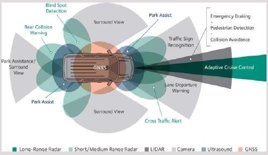
A visionary paper
Once upon a time, 23 years ago...

• ... Vehicle navigation systems are slowly being introduced into the
  world marketplace with the hope that in the very near future they
  will help alleviate traffic congestion and the associated
  environmental pollution

• The vehicles carry an on-board computer that show the vehicle
  location and plots a route, avoiding trouble spots...

• ...Common to all of these systems is the use of vehicle location data
  provided by the Global Positioning System (GPS)...

Garcia-Ortiz et Al., Intelligent Transportation Systems-Enabling
Technologies. Mathl. Comput. Model. Vol. 22, pp. 11-81, 1995
                                                                          4
GNSS state-of-the-art

• Constellations

• Receivers

• Augmentation Services

• Accuracy

                          5
GNSS - Constellations

Fully Operational
• GPS (Global Positioning System, U.S.)
• GLONASS (Global’naya Navigatsionnaya Sputnikovaya Sistema,
  Russia)

Partially Operational (under development)
• BeiDou (China)
• Galileo (E.U.)
• QZSS (Quasi-Zenith Satellite System, Japan)
• IRNSS (Indian Regional Navigation Satellite System, India)
                                                               6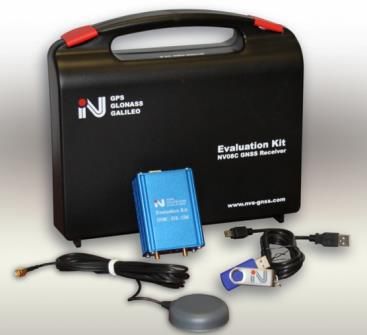
GNSS - Receivers

  Raw observations
  (C/A and L1) now
                           Research activities
  available within
  Android tablets &        in progress for
  smartphones (Jun 2016)   dual frequency

       GSA GNSS
   Raw Measurements
       Task Force                                7
GNSS – Receivers
        Released 16 Jan 2018   Crucial role of mass-market receivers
        in European GSA site
                               Satellite Positioning Performance Assessment
                               for Road Transport (SaPPART) – COST Action
                               TU 1302
                               • GNSS have a significant potential in the
                                 development of ITS and mobility services,
                                 expected to deliver many benefits including
                                 reducing congestion, increasing capacity and
                                 improving safety
                               • The road sector is estimated to represent
                                 more than 50% of the GNSS market and 75%
                                 when we consider the mobility services on
                                 smartphones

                               Website for GNSS data management under
                               Android
                               https://developer.android.com/guide/topics/s
                               ensors/gnss.html
                                                                                8
GNSS – Augmentation Systems

                              9
GNSS – Accuracy (good sky visibility)
Standard mass-market receivers (No possibility for GBAS)
• Stand-Alone: 5-10 m (Code C/A Single Point Positioning, SPP)
• SBAS augmented: 2-3 m (Code C/A + SBAS correction SPP)

Low-cost/Android mass-market(?) receivers
(Adding GBAS augmentation via Internet)
• Differential Positioning (DGPS): better than 1 m (Code C/A Double
  Differences, DD)
• Network Real Time Kinematic (NRTK): dm(s) level (Phase L1 DD) – basic
  requirement for autonomous driving

Geodetic receivers/Dual frequency mass-market(?)
(Adding GBAS augmentation via Internet)
• NRTK (DD): cm(s) level (Dual frequency L1,L2)
• Precise Point Positioning, PPP: cm(s) level (Dual frequency L1,L2 + orbits
  and clocks correction) – optimal for autonomous driving                      10
GNSS open issues for Autonomous Driving

• Full constellations deployment and interoperability
• Dual frequency – multi-constellations low-cost receivers:
  - announced (21 Sept 2017) by Broadcom for
  smartphones/tablets, still to be implemented in devices
  - some other factories on-the-road
• Low-cost dual frequency antenna with optimal gain
• GNSS performance highly influenced by the environment and
  operational scenario
• Current lack of a panEuropean certification process based on
  agreed standards, hampering the realization of the expected
  benefits
                                                                 11
EU GNSS projects on Autonomous Driving
SaPPART-COST Action TU 1302 - http://www.cost.eu/tud/TU1302 - 2015/17
• definition and the assessment of performance for the GNSS-based
positioning, to boost the use of GNSS-based ITS and mobility applications
• SaPPART White paper: SaPPART White paper as PDF
• SaPPART Handbook: SaPPART Handbook as PDF
ESCAPE project - http://www.gnss-escape.eu/what-is-escape/ - 2016/19
(European GSA Fundamental Elements programme -
(http://www.gsa.europa.eu/)
• preliminary design of ESCAPE GNSS Engine (EGE), an innovative
positioning engine that leverages Galileo to provide the positioning
component in autonomous vehicles (integration with cameras, IMU)
• main feature of the ESCAPE automotive-grade GNSS receiver is to be dual
frequency and multi-constellations
12The reverse:
how Autonomous Driving impacts on GNSS/Geomatics?
• GNSS - Innovations to deal with multipath, signal visibility and
geometry
• GNSS - Broadly available PPP and network RTK corrections
delivered either through mobile IP or satellite
• GNSS - Improved integrity monitoring and fault detection
• Geomatics - High Definition (highways, urban centers and trunk
roads that achieve 10-cm localization w.r.t. WGS-84) map-based
navigation
• Geomatics - Solutions enabling real-time mapping
13Conclusions and Prospects
• GNSS technology is becoming more and more mature
• GNSS technology to become really impacting for autonomous
driving demands for new policies and regulations
• New policies and regulation can boost wider and wider GNSS
and Geomatics market
14Thank you very much for your kind attention
You can also read