Modeling of Conservation Priority Zone for the Helmeted Hornbill (Rhinoplax Vigil) In Silokek Geopark Area, West Sumatra - Preprints.org
←
→
Page content transcription
If your browser does not render page correctly, please read the page content below
Preprints (www.preprints.org) | NOT PEER-REVIEWED | Posted: 27 September 2020                               doi:10.20944/preprints202009.0676.v1

          Modeling of Conservation Priority Zone for the Helmeted Hornbill
          (Rhinoplax Vigil) In Silokek Geopark Area, West Sumatra
          Rizki Atthoriq Hidayat*, Natasyah Febriani, Muhammad Hanif, Henzulkifli Rahman
          Geography Science, State University of Padang, Padang 25132, Indonesia
          *Correspondence: email. Rizkiatthoriq99@gmail.com

          ABSTRACT

          Helmeted hornbill (Rhinoplax vigil) is a protected wildlife in Indonesia according to enactment no. 5, 1999 about
          Conservation of Natural Resources and its Ecosystems and Government Regulation no. 9, 1999 about plant and wildlife
          preservation. Helmeted Hornbill habitats spread in five country regions: Myanmar, Thailand, Malaysia (Malayan Peninsula
          and Serawak), Brunei, and Indonesia (Sumatra and Borneo). Silokek Geopark which located in Sijunjung Regency, West
          Sumatra Province, Indonesia is an identified location of Helmeted Hornbill habitat existence. Beside its uniqueness in
          physics, this bird also have an ecological function as seed dispersal in nature. The utilization of Remote Sensing (RS)
          technology and and Geographic Information System (GIS) is highly useful in identification the Helmeted Hornbill habitat
          distribution in this research. Geographic dateset used in this research are Landsat OLI 8 imagery, Shuttle Radar Topographic
          Model (SRTM), Coordinate points of Helmeted Hornbill existence and location assesment, and other dataset related to
          administration boundary in Silokek Geopark. This research aims to find conservation priority zone of Helmeted Hornbill in
          Silokek Geopark. By utilizing Maximun Entropy (MaxEnt) algorithm with finding points and location assessment, we can
          determine the distribution of Helmeted Hornbill habitat in Silokek Geopark based on habitat likeness. This research
          produces the model of conservation priority zones in geopark silokek which are distributed in hilly protected forest area and
          the distributions are concentrated in the center and noth east part of our researc area. This model is highly influenced by
          forest texture (25.7%), distance of patches (24.3%), and distance of settlement.

          Keywords: habitat modeling; helmeted hornbill; conservation

          1.  Introduction                                                     lower tail cover it is white. The side tail is white with a
               Hornbill is a very unique and exotic bird species.              black band before the tip. The beak and ivory are red,
          This species is protected in Indonesia according to                  except for the ivory in the front and about half the beak
          enactment no. 5, 1999 about Law Conservation of                      to the tip which is ivory (KLHK. 2018).
          Natural Resources and its Ecosystems and Government
          Regulation no. 9, 1999 about plant and wildlife                            Helmeted Hornbill distributed in Sumatra and
          preservation. Assessment from IUCN Helmeted Hornbill                 Borneo, six locations are recently identified as Helmeted
          in Red List Category and Critically Endangered (CR)                  Hornbill existence are three in Borneo and thee in
          species and listed in Appendix 1 by CITES.                           Sumatra regions comprising Kutai National Park, Barito
                                                                               Ulu, international corporation of Indonesia in east
                Helmeted hornbills Rhinoplax vigil are unique                  Borneo, Hutan Harapan - Jambi, Bukit Barisan Selatan
          among the Bucerotiformes in having solid ‘ivory’                     National Park, and entire part of Lampung Province.
          casques that are used sometimes in aerial displays where             Helmeted Hornbill generally tend within the forest which
          individuals collide casque-to-case que in mid-air (Kemp              far from human activity. Nur (2013) has found 16
          1995). The morphology of helmeted hornbill is easily                 individual helmeted hornbills in Solok Selatan West
          recognized, because the large size with a longer middle              Sumatra. Nevertheless, in Goepark Sikokek West
          tail. The sizes of the ivory hornbills are as follows: more          Sumatra there has many biodiversity including helmeted
          less 140 cm total length; wing length between 42-48 cm               live in the natural land scape (Kusuma. 2019). From the
          with wing length females tend to be shorter; the length of           land cover map of 2014 it has revealed about 27,4 million
          the middle tail feathers ranges from 60-77 cm and the side           hectares of primary dry forest cover had potential for
          tail lengths of about 30-38 cm; The length of the beak               Helmeted Hornbill habitat in Sumatra (Kumara. 2006;
          ranges from 16.2 to 20.4 cm, while the length of the ivory           KLHK, 2018). The condition highly support for the
          ranges from 7.3-9.4 cm. The hair of the ivory hornbill is            sustainability of this species. Largely, It occupies
          dominated by black, brown and white. The wings are                   lowland forest habitats (Jain et. al, 2018). it appears to
          black with white tips, with brownish wing feathers. The              prefer hilly terrain away from the coast (300 – 1,100m,
          chest hair is black, while from the upper abdomen to the             occasionally to 1,500m) but there are significant

               © 2020 by the author(s). Distributed under a Creative Commons CC BY license.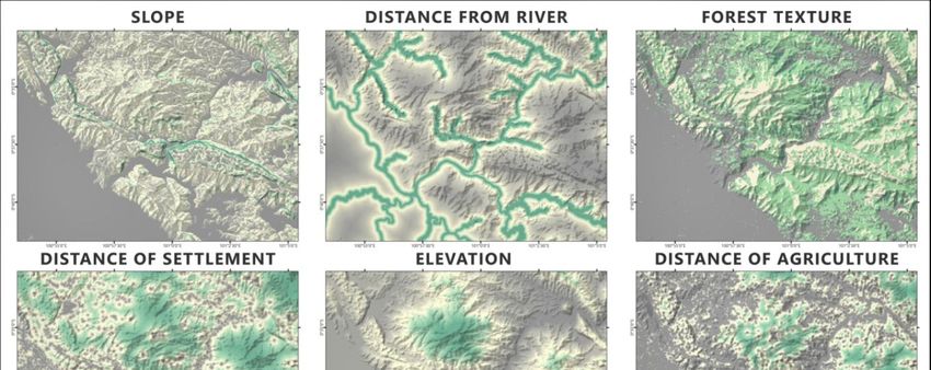
Preprints (www.preprints.org) | NOT PEER-REVIEWED | Posted: 27 September 2020                           doi:10.20944/preprints202009.0676.v1

          strongholds in some lowland forest areas. This locations         environmental change (McDermid et. al., 2005).
          where the Helmeted Hornbill distribution it have annual          Sustainable conservation action is needed to deploy
          rainfall >3000 mm (Kinniard and O’Brien, 2007). In               toward Helmeted Hornbill habitat because their habitat
          prime habitat, recorded average density in Sumatra varies        occupancy already decline followed by hunting and
          is from 0.19 to 2.6 birds/km2 depending on habitat               trading this wildlife. During the last decades, progress in
          quality and latitude (Jain et. al, 2018). Helmeted Hornbill      remote sensing technology is increasingly contributing to
          also found in logged secondary forest in Jambi which still       the identification and quantification of species, structures
          holds large trees which height attain 30 m or more, and          and objects relevant for habitat quality monitoring
          30 m of free branches height (Azizah, 2010). Helmeted            (Lengyel et. al., 2008).
          Hornbill home range size has not been estimated, and so
          far no radio or satellite tagging has been attempted (Jain             The area of National Geopark Silokek is located in
          et. al, 2018).                                                   administration of District Muaro Silokek and Durian
                                                                           Gadang, by the larges area is more less 300 km
                 Selective living requirements of Helmeted                 (Muharram et al. 2020). Geopark Silokek is also as home
          Hornbills makes them occur in only particular locations          to protected flora and fauna. Some protected wildlife in
          depending on food supply, secutiry, and comfortability           this area are Sumatran Tiger (Panthera tigris sumatrae),
          which support the habitat suitability. Disconsertingly,          Tapir (Tapirus indicus), Anteater (Manis javanica), and
          little is known about the basic biology and ecology of the       Helmeted Hornbill (Buceros vigil) (Kusuma. 2019). The
          species (Kaur et. al., 2019). It extends into adjacent           biodiversity is richness of this geopark it has support by
          mature secondary forest, but avoids open areas, disturbed        ecosystem tropical rain forest, big river (Indragiri River),
          forest and peat swamps (Kinnaird & O’Brien, 2007; Lum            and wildlife within. In this research, we bordered the
          & Poonswad, 2005; Poonswad et al., 2013)As the                   location as a region of interest in area of 65540.66
          availability of suitable nest sites plays a major role in        hectares (655.41 km2). There are 7 sub-districts and 18
          population recruitment of cavity-nesters (Cody 1985).            villages in our research location. This location is
          The Helmeted Hornbill has the most specialised diet of           dominated by forests on hilly landscape, and particularly
          any hornbill, largely consisting of fruits(Jain et. al, 2018).   in southwestern part is dominated by plantations and rice
          Up to 60% of its diet may consist of six or seven fig            fields. In Geopark Silokek the one of many endemic
          species (Poonswad et al., 2013; Kitamura et al., 2011). In       species in this area is helmeted hornbill. Purpose of this
          Sumatra, about 98% of its foods are ficus (Hadiprakarsa          research is to This study aims to modeling the suitability
          & Kinnaird, 2004). Hornbills play an important role as           habitat as the conservation priority, measuring priority
          seed dispersal agents for tropical forest regeneration           conservation area, and determining the highest variable
          (Kinnaird & O’Brien 2007; Walker 2007; Kitamura                  contribution in modeling the conservation priority zone.
          2011; Naniwadekar et al. 2015; Corlett 2017),Sometimes
          when male feeding the female and cheeper to the nest, it         2. Methodology
          falls the fruits to the ground. It could disperse various        2.1 Image Analysis
          fruits and seeds far away from the origin because of it
          wide cruising range (KLHK,2018).                                 In this research there has utilized a digital image of
                                                                           Landsat OLI 8 and SRTM (Shuttle Radar Topographic
                Beside habitat loss due to deforestation and land use      Mission) this data free access from website USGS
          transformation, helmeted hornbill population also                (United States Geological Surveys) which the cell
          significantly declined by poaching activity. The                 resolution is 30 x 30 meters. These images has processed
          population is currently believed to be undergoing rapid          using is Maximum Likelihood as the supervised
          decline as a consequence of extensive poaching in                classification for extraction imagery to land cover map on
          Indonesia (Sumatra) (BirdLife International, 2017;               Geopark Silokek. This method is a pixel based
          Krishnasamy et al., 2016). Helmeted Hornbills are hunted         classification. Supervised classification techniques in
          to supply strong demand for their solid casques (Jain et.        contrast, use intensive hands-on training in an attempt to
          al, 2018). This condition pushed the number of Helmeted          extract predefined information classes from the
          Hornbill population. Just two seizures were reported from        explanatory, and, as such, require specific a priori
          Sumatra, the first (involving 48 heads) in Padang, capital       knowledge (McDermid et. al., 2005). The maximum
          of West Sumatra province, in April 2013, the second              likelihood classification is the most effective
          (involving seven beaks) in Jambi province in May 2014            classification method if equipped by accurate training
          (C. Bastall et. al, 2016). Environmental management and          data and one of the most used algorithm (Perumal and
          conservation agendas commonly include requirements               Bhaskaran, 2010). This image classification works by
          for mapping and monitoring wildlife habitat for the              accumulating the pixel values from marked polygon
          purpose of estimating population sizes, identifying              samples of a land use class, then other an unmarked
          critical habitat, and predicting the impacts of                  location which has the same pixel value with marked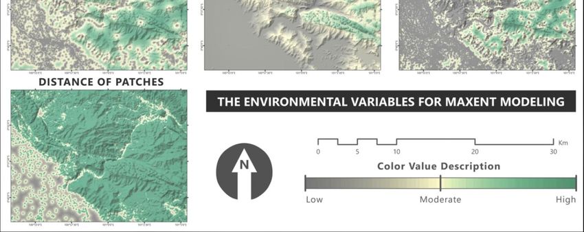
Preprints (www.preprints.org) | NOT PEER-REVIEWED | Posted: 27 September 2020                            doi:10.20944/preprints202009.0676.v1

          location will be in one class with marked polygon                 2.3 Species Present Data
          samples. These land use Geopark Silokek then processed
          for environmental variables as our consideration to                     The present samples of helmeted hornbills were
          determine the conservation priority zone for the helmeted         obtained in field observation. To get the data of this
          hornbill. There is also apply NDVI (Normalized                    species, we did observation and searching them used
          Difference Vegetation Index) algorithm to obtain the              binoculars, when we found the position this species on
          forest texture by quantifying NDVI. Nevertheless there            the tree, then plotting of coordinate points of the presence
          used SRTM imagery to extraction elevation                         of this species was deployed by using Global Positioning
          (automatically exist, because this data contains point z          System (GPS) cartometric approach. The records are also
          information) and slope. All of data as our environment            based spatial approach as the logic of this species to
          variables then would be statistically quantified in MaxEnt        strengthen the final result the model. The recorded
          software to gain the main result of this research.                coordinate points then converted and processed to be
                                                                            readable in MaxEnt software.
          2.2 Transformation to Logarithm Natural (ln)
                                                                            2.4 Environmental Variables
                This process value transformation is intended to
          distance variables (river, settlement, agriculture, and           Environmental variables are used for variable in MaxEnt
          patch). Firstly, the raw datasets of these variables were         to result the model paraller with species present data.
          calculated with euclidean distance algorithm. The                 These variables refer to the characteristics of species
          distance is calculated from the center of a feature into          habitat. The suitability habitat shown by how the present
          other feature center, which the highest value is in the           species data interact with these variables, where the
          middle cell of both distance and the lowest value is in the       points condense will determine the result of this model.
          source cell. The reason why we modify the raster value            These environmental variables are slope, distance from
          of these variables with logarithm natural is to give the          river, forest texture, distance from settlement, elevation,
          natural effect and enhance the result especially the model        distance from agriculture, and distance of patches. These
          look sharper. Each distance variable values is estimated          variables will be analyzed more in the result and
          in the calculation of distance e’di transformation. The           discussion part. These variables are chose to considering
          distance by euclidean distance is massively represented.          the topographic condition, food supply, inter-patches
          We consider that the natural effect to other environment          access, and the threat potential to habitat.
          is not as that massive. So, we need to convert the value of
          the euclidean distance to get natural effect by using                   Distance of settlements and agriculture reveal the
          logarithm natural (ln). The transformation is stated with         risk of threat because these are the distance of to reach
          this equation (Hanif, et al. 2020):                               the places where human activities. It extends into
                                                                            adjacent mature secondary forest, but avoids open areas,
                        e’d = ln (1+ ed)                                    disturbed forest and peat swamps (Kinnaird & O’Brien,
                        e’di = (Max e’d+1) - e’d                            2007; Lum & Poonswad, 2005; Poonswad et al., 2013) If
          Where:                                                            the distance of this species is closer to these both
          ed                  : input parameter (euclidean distance)        variables, the accessibility of hunting will be easier.
          ln                  : logarithmic natural                         Despite of that forest texture gained from the image
          e’d                 : output from logarithmic natural of          processing using NDVI algorithm. This variable is
                                        ed                                  essential because it considers the nesting and food supply
          Max e’d             : maximum raster of e’d                       for this species. Helmeted Hornbill to known living in
          e’di                : transformation of euclidean distance        primary evergreen forest (KLHK, 2018). Plants in
                              for input parameter.                          lowland tropical rain forest poses is various pattern
                e’di value is the inverse of e’d value. The inversion       conception like semi-annual, annual, and supra-annual,
          of e’d value is because this value is no longer as the            so that some trees could change simultaneously and
          distance value but as the standardized value. Which               others seasonally (KLHK, 2018).
          means if the occur point is closer to the source feature,
          the raster value is higher.

                                                        Table1. Environmental variables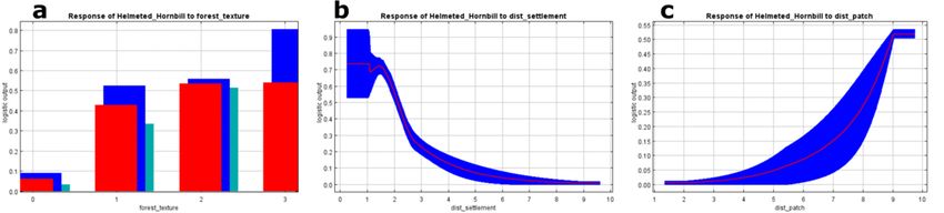
Preprints (www.preprints.org) | NOT PEER-REVIEWED | Posted: 27 September 2020                              doi:10.20944/preprints202009.0676.v1

                                No.            Variables                      Source                  Data type
                                 1           Forest Texture               NDVI equation               Categorical
                                 2             Elevation              SRTM imagery calculation        Continuous
                                 3               Slope                SRTM imagery calculation        Continuous
                                 4        Distance From River             e'di calculation            Continuous
                                 5       Distance of Agriculture          e'di calculation            Continuous
                                 6        Distance of Patches             e'di calculation            Continuous
                                 7       Distance of Settlement           e'di calculation            Continuous
        .

            2.5 Maximum Entropy Modeling                                      historical anthropogenic disturbances) (Brotons et al.
                                                                              2004).
                  There are some methods used for Species
            Distribution Modeling (SDM). One of those is MaxEnt                     Maxent provides output data in raw, cumulative,
            (Maximum Entropy). Maxent is recently introduced                  and logistic formats (Philips and Dudı´k, 2008). Raw is a
            modeling technique, achieving high predictive accuracy            main format of Maxent Processing and the basis of the
            and enjoying several additional attractive properties             next processing with GIS tools as the for the analysis. The
            (Philips and Dudı´k, 2008). Maxent model is a machine             cumulative format is scale independent with scores for
            learning/data mining program that evaluates the                   locations equal to the probability of finding the species of
            distribution probability of a species in relation to              interest at that site plus all others with equal or lower
            environmental factors (Yang, 2013; Philips, 2006;                 probabilities (Baldwin, 2009). The logistic format is
            Philips, 2004). The maximum entropy algorithm is                  currently recommended given that it provides estimates
            deterministic and will converge to the maximum entropy            of the probability of occurrence as predicted by included
            probability distribution (Philips et al., 2006). The basic        environmental variables (Philips and Dudı´k, 2008).
            principle of the statistical approach implemented in
            Maxent is the estimation of the probability of a                  3. Result
            distribution with maximum entropy (that is, the most              3.1 Environmental Variables
            spread out or the most uniform distribution) given a set
            of conditions (the environmental characteristics of the                 Result of image analysis is land cover map, there
            site where the species is detected) that shows our                has found land uses classification. Several information of
            incomplete information regarding the distribution of the          this data has elected as environment variables. These
            species (Phillips et. al., 2006). Runs were conducted with        variables determine this modeling. These variables were
            the default variable responses settings, and a logistic           choosing based on the field condition geographically and
            output format which results in a map of habitat suitability       the tendency this species occurs. The difference in the
            of the species ranging from 0 to 1 per grid cell,                 number of variables will also cause the difference in the
                                                                              result of species distribution modeling. So, in choosing
                 Where in the average observation should be so close          the environmental variable, it is supposed to be selective
            to 0.5 (Elith et. al., 2011). While the best result of this       and suitable with the essential spatial requirement of
            model should be close to 1 and closer to 0 the value will         helmeted hornbill habitat. These variables are suspected
            get worse. The one of the important information of                have influence toward the helmeted hornbill habitat.
            MaxENt is AUC with showed model performance as <
            0.7      (poor      model      performance),       0.7–0.9             These environmental variables are slope, distance
            (moderately/useful), and > 0.9 (excellent) (Gunawan and           from river, forest texture, distance from settlement,
            Prasetyo.. 2013; Baldwin, 2009). Although methods                 elevation, distance from agriculture, and distance of
            employing presence/absence data are often prioritized,            patches. The Maxent algorithm will process these
            present only modeling approaches should be used when              variables by considering the present data. For more detail
            the objective is to identify suitable habitat of a given          how distribution the environmental variable on this
            species, particularly when the current distribution of the        research area, it present on the figure bellow.
            species is unknown or has been dramatically altered (e.g.,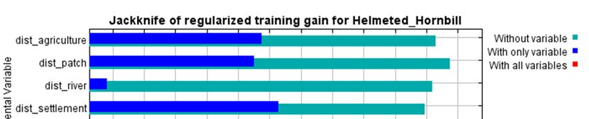
Preprints (www.preprints.org) | NOT PEER-REVIEWED | Posted: 27 September 2020                            doi:10.20944/preprints202009.0676.v1

                                           Figure 3. The environmental variable used in MaxEnt Modeling.

                Land use type was extracted from process image             destination of migration or the area of exploration, if the
          classification. It is consist of forest, shrub, rice field,      distance of inter patch is close to other patch, it will ease
          settlement, water body, and plantation. Where this land          the route of this species. Distance from settlement and
          use, will be basic data to identify the Helmeted Hornbill        agricultural area will affect how comfortable hornbills
          habitat characteristic, but not all land use classes are used    are in their habitat. When hornbills to often meet humans
          in this modeling as the environmental variables. The land        around their nests. He will feel insecure because this
          cover class did select for Maxent Processing such as             condition will disturb this bird. The human activity
          forest, settlement, rice field, and plantation.                  around the settlement it also will influence the landscape
                                                                           around this place, for example human will converting or
                Distance parameters including distance from river,         cutting down trees for them necessary this activity will be
          settlement, agriculture, and distance of patch habitat. The      pressure for them.
          energy from patch habitat will represent the level of
          connectivity of habitat centralization or even threats.          3.2 Modeling of Conservation Priority Zone
          Then distance from rivers and the distance of patches it
          has reveal the centralization potential habitat of Helmeted            The relation between average sensitivity and
          Hornbill, because the closer to both parameters the easier       fractional predicted area shown by picture below. Gained
          this species in inhabiting and gaining food to survive.          from repicated maxent model, this crve is the reveiver
          Rivers provide the need of primary need of living (water)        operating characteristic (ROC). The average training
          for all organisms and as the energy flow. Distance of            AUC score reached 0.923 with the standard deviation is
          patches is indicates how interaction among habitat to            0.017. This result reveals high accuracy because the
          transfer the species can reach other habitat patches as the      AUC value is nearly 1.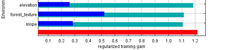
Preprints (www.preprints.org) | NOT PEER-REVIEWED | Posted: 27 September 2020 doi:10.20944/preprints202009.0676.v1
Figure 4. Model accuracy with AUC mean value.
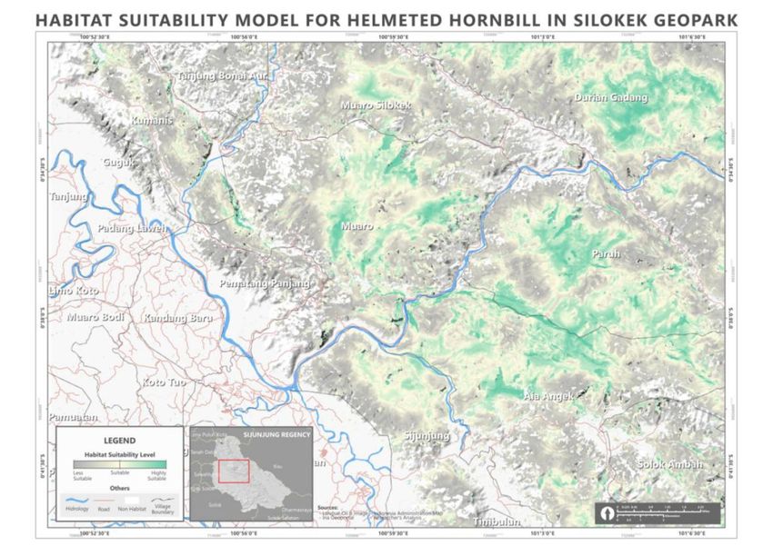
The modeling is according to the suitability of that the zone is more prioritized to conserve which means
helmeted hornbill habitat in Silokek Geopark area as the this area is highly suitable for the Helmeted Hornbill
result of MaxEnt processing. MaxEnt is able to map the based on preset point data where grey color is not
species distribution where the value of each pixel signifies the zone is less prioritized because it has low
represents the probability of present species in the suitability towards Helmeted Hornbill habitat.
suitable habitat. In the map below, green color signifies
Figure 5. Helmeted Hornbill conservation priority zone in Silokek Geopark.
Based on species present point data, the point steep terrain, far from settlement and agriculture, and
positions tend to be in dense canopy forest, riverbank, high elevation. The area abround these present pointsPreprints (www.preprints.org) | NOT PEER-REVIEWED | Posted: 27 September 2020 doi:10.20944/preprints202009.0676.v1
then considered as the priority for the helmeted hornbill be prioritized for potential habitat. It should be limited,
conservation in Silokek Geopark Area. We classified the that this determination focuses on the fact that the
level of conservation priority become three levels (low, analysis of environmental variables does not involve
moderate, and high). indicators such as public policy.
The potential area to become priority conservation The spot area potential for conservation habitat
is strongly influenced by environmental variables. Which spread in several locations, especially in locations with
are basis for consideration environmental data. There is steep hilly conditions and tight vegetation and far from
each environmental variable will give effect to the the reach of human daily activities. The potential area
surrounding space. By considering the effect of each of including many district. This table reveals the percentage
these values and read in the MaxEnt statistical of each class that occur in 7 sub districts in our area of
calculation, we succeeded in delineating areas that could interest:
Table 2. The percentage of conservation priority level for the helmeted hornbill in Silokek Geopark area.
Percentage (%)
Sub District Total Area (Ha)
Low Moderate High
Iv Nagari 6327.86 0.71 0.20 -
Koto Tujuh 3423.79 4.49 0.47 0.05
Kupitan 656.51 0.07 0.04 -
Lubuk Tarok 4634.86 0.56 0.27 0.03
Sijunjung 45260.00 30.65 22.40 16.55
Sumpur Kudus 4723.85 33.52 10.48 3.24
Tanjung Gadang 513.19 21.11 6.52 2.87
.
3.3 Variable Contribuition have more than 20% contribution in this model, those are
forest texture, distance of patches, and distance of
Variable contribution in MaxEnt processing will settlement. These variable contributions also show the
be the ranking of each variable according to the sort of the influence of variables from the strongest to the
contribution. Table 3 reveals the variable contribution in weakest. With variable contributions, we can know the
percent. The table shows the top three variables which factor that can inhibit the Helmeted Hornbill.
Table 3. Variable contribution for the Helmeted Hornbill conservation priority zone
Percent Permutation
Variable
contribution importance
Forest texture 25.7 4.5
Distance of patch 24.3 45.2
Distance of settlement 22.4 20.9
Distance of agriculture 11 6.3
Slope 7.8 8.3
Distance from river 6.6 10.8
Elevation 2.1 3.9
We discovered that forest texture is the highest
percent contribution in this modeling. The rougherPreprints (www.preprints.org) | NOT PEER-REVIEWED | Posted: 27 September 2020 doi:10.20944/preprints202009.0676.v1
texture of forest indicates the more occurence of
Helmeted Hornbill and vice versa.
Figure 6. Response charts for the highest variable contributions : a) forest texture, b) distance of settlement, and c)
distance of patch.
The response curves above represent how each because the access easiness to their habitat. This factor is
value of variables correlates with maxent index value in suspectible by hunting and deforestation.
rthe range from 0 to 1. foret texture as the most
contributing variable has four roughness classes (less The value escalation of maxent result parallelly
rough, moderate low, moderate high, and highly rough. followed by the value in patch distance. The higher the
We discover the class of this variable which has the patch distance value shows better improvement in
highest influence toward the modelling is in moderate maxent value. This variable contributes in providing the
high class followed by highly rough and low moderate. home rangee of the helmeted hornbil in migration or
This class also indicates as the most potential of looking for food source.
occuerence of the helmeted hornbills in Silokek Geopark.
This following chart reveals the result of
Distance of settlement as the second highest jackknife test toward variable importance. Distance of
contribution is the result of anthropogenical activity settlement is the highest regularized traning gain, which
especiall for inhibition and economic ativity. This means this variable has the most crucial information by
variable is highly impactful for the occurence of the itself. When being omitted, this variable decreases the
helmeted horbill. The closer the settlement to the home grain the most, which consequently this variable has the
range of the helmeted hornbill, the higher threat level most information which is not present within other
variables.
Figure 7. Jackknife test result of variable importance
4. Discussion animals cannot be carried out. From the selection of
environment variables that represent helmeted hornbills
The main key that is very important in maxent habitat indicators that can be spatially analyzed, and
modeling is the present data, if present data on the represent geographic conditions, this greatly influences
distribution of hornbill encounters, then statistical the success of the MaxEnt model. The justification for
prediction analysis of the possible distribution of thesePreprints (www.preprints.org) | NOT PEER-REVIEWED | Posted: 27 September 2020 doi:10.20944/preprints202009.0676.v1
this selection certainly has strong reasons. Potential altered in massive to development will contributing the
habitat conditions for hornbill conservation such as forest real treatment to habitat as dropped habitat capacity
vegetation cover, is one of the main keys in MaxEnt (Hanif et al, 2017, 2019).
modeling because hornbills themselves live in wet
tropical forests. The elevation conditions of potential
habitat locations for hornbill conservation are found at Distance of patch related to the mobility and home
locations with high elevations and steep slopes. range of this species. The accessibility to different patch
Following statement Johns, (1988; Kemp, et al., 2017) helps helmeted hornbill in exploring the food source,
helmeted hornbills are known live in primary evergreen nest, or migration destination. Habitat patches are the key
forest, especially in foothills with wavy topography, but variable in this model, because ecologically this will
this species is selectively logged forest which still tend affect the distance between the habitat patches to migrate
natural. This species inhabit in evergreen primary forest. for these species. Habitats that are fragmented due to
Rough forest texture, wide canopy cover, high trees, and logging do not always provide large trees capable of
helmeted hornbill toward nesting and food (Jain et. al., supporting hornbills to build nests for breeding. The
2018). Vegetation density strongly in determining consequence of the distance between habitats is the
ecosystem connectivity and condition of dense migration capacity and availability of food supplies in
vegetation in the forests provides is important for species fragmented habitats. There has interpreted that from
survival and biodiversity (Rahman, 2020). The looking at the NDVI value which represents the forest
statements from previous researchers strongly support texture in the habitat patch. It is unlikely that the area will
the findings of our study. Where in this study habitat be able to supply the ecological characteristics that are
helmeted hornbill in Geopark Silokek it is very clearly generally favored by ivory hornbills. Based on statements
that it information vegetation index as the variable forest in previous research, it truly related with output research,
texture has given a big contribution in this mode. This where the nest made at natural cavity in large living tree.
variable highly affects the most fundamental aspect to The cavity which could nest this species is on the large
delineation of priority conservation areas is in accordance and tall tree. Related to the tree, fruit is available food
with the requirements of life and the habits of life of which is also as tall and large tree. In addition, the
helmeted hornbill in Silokek. dependence of the ivory hornbill on the presence of a
sturdy and strong tree for nesting can also indicate the
The settlement indicator is the second variable that
health level of an ecosystem (Jain et. al., 2018; KLHK,
is highly considered in the habitat conservation potential 2018). Poonswad et al. (2013), in radi-tracking surveys
model. Human activities around residential areas become of the related Great Hornbill (Buceros bicornis) from Kao
a form of stress pollution on the ivory hornbills, this is Yai National Park in Thailand show that daily movement
because they will feel pressure and threats, because in the of male can over 0.7 - 6 km2, and up to 7 km2 during the
area around residential areas there will be competition for breeding season. It is compared in (Jait et al. 2018) that
Helmeted Hornbills have a more specialised diet that
land use between animals and humans. Hornbills, which
Great Hornbills, and their home range is consequently
are omnivore birds, will experience a depression in the likely to be greater. This variable also determines how the
availability of food around settlements due to land mobility of Helmeted Hornbills in isolated patch could
management activities and hunting of animals which are access larger patch as the core area. In the prespective of
also hornbill food. Nevertheless we made assumption that Helmeted Hornbills, fragmented habitat is still able to
settlements become an obstacle to connectivity between provide the resource to espouse their population in nature
ecosystems in Silokek. Helmeted Hornbills generally (KLHK, 2018).
tend to live in the forest which far from human (Kumara, The effectiveness of conservation priority areas,
2006). The high poaching rate toward this species, makes from the analysis map it is clear that the potential habitat
the occurence of human settlement could be threat for conservation is scattered in many locations, further
because the conveinence to access their habitat is near consideration needs to be done in this analysis.
through settelement. The occurence of this species will Conservation should not only measure areas with
be much safer if in the deep forest and far from settlement conservation under law status. It is feared that the
imbalance of population size and habitat availability in
or other artificial landscapes (mining area, industrial, and
the future. If the focus of conservation it is only in
so forth). But settlement is big impact toward conservation legal status, so species that are scattered in
biodiversity. There are some fragmented natural non-conservation areas will be easily hunted down and
landscape ecosystem areas sorrounded by built-up area killed to be traded.
(Hidayat, 2019).The anthropogenic or semi natural hasPreprints (www.preprints.org) | NOT PEER-REVIEWED | Posted: 27 September 2020 doi:10.20944/preprints202009.0676.v1
The ivory hornbill has not become a priority issue, so Baldwin, R. (2009). Use of maximum entropy
monitoring activities and funding are still limited.
modeling in wildlife research. Entropy, 11 :
Hunting is carried out outside the conservation area
(KLHK, 2018). As well the environmental and forestry 864 - 866.
ministry police on protective personnel in the
conservation area remain very meager (Arinta, 2017). Beastall, C., Shepered, C., Hadiprekarsa, Y., &
Effective conservation actions should thus not focused on Martyr, D. (2016). Trade in the Helmeted
protecting their natural habitat and enhancing the
connectivity however the action plan also curtail the Hornbill Rhinoplax vigil : the ‘ivory
illegal trade and their derivatives (Hanif et al. hornbill’. . Bird Conservation International,
2019;2020). Green political theory is a compatible theory 26 : 137 - 146.
analyses problem that countries should do in managing
resources and making non-deskctional polices again the
environment, and it can also recognize Indonesia barrier Brotons, L., Thuiller, W., Araujo, M., & Hirzel, A.
to the foreign bink-based ivory trade (Arinta,2017). This (2004). Presence-absence versus
theory need binding agreement and international law, law presence-only modeling methods for
designed to regulate the difference in purpose and solve
environment issue, and it also state a disciplinary action predicting bird habitat suitability.
is required in an institution, thereby affecting the Ecography, 27 : 437 - 488.
effectiveness of the institution (Arinta, 2017)
Cody, M. (1985). Habitat Selection in Birds. New
Conclusion
york: Academid Press.
The environmental variables used in the study include
slope, distance from river, forest texture, distance from Elith, J., Phillips, S., Hastie, T., DudI'k, M., Chee, Y.,
settlements, elevation, distance from agriculture, and & et, a. (2011). A statistical explanation of
distance patches. Helmeted hornbill tend to be in dense
canopy forest, riverbank, steep terrain, far from MaxEnt for ecologists. Divers Distrib, 17 :
settlement and agriculture, and high elevation. 43-47.
Contribution from the MaxEnt the top three variable
which have more than 20 %, that are forest texture, Hadiprakarsa, Y., & Kinnaird, M. F. (2004).
distance of patches, and distance of settlement.
Foraging characteristics of an assemblage
Acknowledgement: of four Sumatran hornbill species. Bird
Conservation International, 14 : S53-S62.
References Jain, Jain , A., Lee J, G. H., Chao, N., Lees , C.,
Arinta, N. (2017). Upaya Indonesia dalam
Orenstein, R., . . . Rao M, (. (2018). .
penanganan wildlife trafficking:
Helmeted Hornbill (Rhinoplax vigil): Status
Perdagangan Rangkong Gading ke
Review, Range-wide Conservation
Tiongkok periode 2012-2015 [Skripsi].
Strategy and Action Plan (2018-2027).
Jakarta: UIN Syarif Hidayatullah .
IUCN Species survival Commission Hornbill
Azizah, N. (2010). Perencanaan wisata Burung Specialist Group.
Rangkong (Famili Bucertotidae) di
Johns, A. (1988). Effects of ” selective” timber
Harapan Rainforest Kabupaten
extraction on rain forest structure and
Batanghari, Provinsi Jambi. Departemen
composition and some consequences for
Konservasi Sumberdaya Hutan dan
frugivores and folivores. Biotropica, 31-37.
Ekowisata, Fakultas Kehutanan Institut
Pertanian Bogor . Kaur, R., Ancrenaz, M., Ramli , R., & Singh, S.
(2019). Observations at a nest ofPreprints (www.preprints.org) | NOT PEER-REVIEWED | Posted: 27 September 2020 doi:10.20944/preprints202009.0676.v1
Helmeted Hornbill Rhinoplax vigil in Hornbill Workshop (p. 248 ). Thailand:
Borneo, Malaysia. Forktail, 34. 68-73. Hornbill Research Foundation.
Kemp, A. (1995). The Hornbills. New York: Oxford Mcdermic, G., Franklin, S., & LeDrew, E. (2005).
University Press. Remote sensing for large-area habitat
mapping. Progress in Physical Geography-
Kinnaird, M., & T.O'Brien. (2007). The Ecology and PROG PHYS GEOG, 29. 449-
Conservation of Asian Hornbills: Farmers
474.10.1191/0309133305pp455ra.
of the Forest. Chicago: University of
Chicago Press. Muharram, N. A., Ramadhani, F., & Putra , B. G.
(2020). ) Optimalisasi Data Digital Terrain
Kitamura, S. (2011). Frugivory and seed dispersal Model Untuk Pembuatan 3d Fisiografis
by hornbills (Bucerotidae) in tropical Dan Geomorfologi Geopark Silokek. e-issn
forests. Acta Oecologica, 37: 531-541. 2622. DOI:
Kitamura, S., Thong-Agree, S., Madsri, S., & 10.31851/swarnabhumi.v5il.3373.
Poonswad, P. (2011). Characteristics of Naniwadekar, R., U, S., K, I., & A, D. (2015).
Hornbill-dispersed Fruits in Lowland
Reduced hornbill abundance associated
Dipterocarp Forests of Southern Thailand. with low seed arrival and altered
The Raffles Buleetin of Zoology 2011, recruitment in a hunted and logged
Suplement No 24: 137-147.
tropical forest. Plos One, 10: e0120062.
KLHK. (2018). Strategi Dan Rencana Aksi
Nur, F. e. (2013). Kelimpahan dan Distribusi
Konservasi Rangkong Gading (Rhinoplax Burung Rangkong (Famili Bucerotidae) di
Vigil) Indonesia 2018-2028. Kawasan PT. Kencana Sawit Indonesia
Krishnasamy, K., Leupen, B., & O.C, O. (2016). (KSI), Solok Selatan, Sumatera Barat.
Observations of the Helmeted Hornbill Prosiding Seminar FMIPA Universitas
Trade in Lao PDR. TRAFFIC Malaysia, 24 Lampung. Lampung.
pp. Perumal, K., & Bhaskaran, R. (2010). Supervised
Kumara, I. (2006). Karakteristik Spasial Habitat Classification Performance of
Burung Rangkong Di Taman Nasional Multispectral Images. Journal of
Danau Sentarum. Bogor: Tesis Sekolah Computing, Volume 2, Issue 2: 124:129.
Pascasarjana Institut Pertanian Bogor. Philips, S. J., & Dudi'k, M. (2008). Modeling of
Kusuma, D. (2019). Geopark Silokek Sijunjung species distributions with Maxent: new
Menuju UNESCO Global Park. Jurnal extensions and a comprehensive
Pembangunan Nagari, Volume 4 Nomor 1 evaluation. Ecography, 31: 161175.
Edisi Juni 2019 : 17-32. Phillips , S. J., Anderson, R. P., & Schapire, R. E.
Lum, S., & P, P. (2005). The Ecology of Hornbills: (2006). Maximum entropy modeling of
reproduction and populations. species geographic distributions. Ecol.
Proceedings of the 3rd International Model, 2006, 190, 231-259.Preprints (www.preprints.org) | NOT PEER-REVIEWED | Posted: 27 September 2020 doi:10.20944/preprints202009.0676.v1
Poonswad, P., Kemp , A., & Strange, M. (2013).
Hornbills of the World: A Photographic
Guide. Draco Publishing and Hornbill
Research Foundation, 212 pp.
Poonswad, P., Kemp, A., & Strange, M. (2013).
Hornbills of the World: A Photographic
Guide. Draco Publishing and Hornbill
Research Foundation, 212 pp.P.
Rahman, H. (2020). Spatial Assessment of
Landscape Structure Changes and
Ecological Connectivity in Pariaman.
Journal of Remote Sensing GIS &
Technology, Volume-6, Issue-2 (May-
August).
Walker, J. (2007). Dietary specialization and fruit
availability among frugivorous birds on
Sulawesi. Ibis, 149: 345-356.
Yang, X. Q., Kushwaha S, P. S., Saran, S., Xu, J., &
Roy, P. S. (2013). Maxent modeling for
predicting the potential distribution of
medicinal plant, Justicia adhatoda L. in
Lesser Himalayan foothills. Ecol. Eng,
2013, 51, 83-87.You can also read