Vegetation Dynamics in the Northern Zones of Niger: Case of the Rural Commune of Tanout (Zinder) and Aderbissinat (Agadez)
←
→
Page content transcription
If your browser does not render page correctly, please read the page content below
ORIGINAL ARTICLE
European Journal of Environment and Earth Sciences
www.ej-geo.org
Vegetation Dynamics in the Northern Zones of Niger:
Case of the Rural Commune of Tanout (Zinder) and
Aderbissinat (Agadez)
Abdoul Kader Soumaila Sina, Nouhou Ali, Amadou Garba, and Bernard Minoungou
ABSTRACT
The present study conducted in the northern zone of Niger aims to show
the impact of land use dynamics on woody vegetation. The methodological Published Online: February 10, 2021
approach consisted in making in addition to the floristic surveys, the ISSN: 2684-446X
analysis of land use maps (LANDSAT images of the years 1975 and 2018).
DOI :10.24018/ejgeo.2021.2.1.111
The floristic inventory allowed the identification of twenty-seven (27)
woody species of which eleven (11) in Tanout and sixteen (16) in
Aderbissinat. The most important families remain the Fabaceae- Abdoul Kader Soumaila Sina*
Mimosoideae which represent 37.5% at Aderbissinat and 45.45% at Engineering and Design Office in
Tanout. The biological types remain dominated by microphanerophytes Environmental Management (BEGEC
which dominate (86.67%), while for the phytogeographic types it is the International) (www.begec-int.com),
Project DTS/FO, Niger.
Sudano-Zambezian and Sudanian species that dominate, with proportions (e-mail: aksoumailasina@gmail.com)
respectively equal to 31.25%. There is a regression of woody vegetation at Nouhou Ali
the level of these communes with a slight loss in Aderbissinat (60588,034 Abdou Moumouni Niamey University,
ha) and an accentuated degradation of vegetation in Tanout Faculty of Letters and Human Sciences,
(781797,738 ha). Department of Geography, Research
Laboratory Sahelo-Saharan Territories,
Niger.
Keywords: Vegetation Dynamics, Sahel, Niger. (e-mail: nouhougeo@yahoo.de)
Amadou Garba
Abdou Moumouni University of Niamey,
Faculty of Science and Technology,
Department of Biology, GARBA
Mounkaila Laboratory, Niger.
(e-mail: garbaamadou10@yahoo.fr)
Bernard Minoungou
AGRHYMET Regional Center, Niger.
(e-mail: minoungoubernard@yahoo.fr)
*Corresponding Author
forest products are the main factors in the degradation of
I. INTRODUCTION AND ISSUES plant formations in Niger's Sahelian ecosystems.
The Sahel is constantly undergoing changes in both land In the northern zone of Niger, the degradation of plant
use and floristic recomposition. This degradation of formations is characterized by the reconversion of
ecosystems in developing countries is the second most agricultural ecosystems (e.g. agroforestry parks) into arid
worrying environmental issue of the 21st century after ecosystems unsuitable for agriculture. The deterioration of
climate change [1], [2]. While at the global level, forest climatic conditions and anthropic activities are accentuating,
losses for the period 2005-2010 were 0.14% per year, West resulting in increasingly harmful effects on the ecological
Africa stands out with an estimated deforestation rate of and socio-economic levels.
0.46% [3]. The Sahelian zone, characterized by limited and
vulnerable forest resources, saw an annual decline of 1.07%
in forest cover over the same period [3]. The degradation of II. MATERIAL AND METHOD
forest ecosystems, the economic lungs of rural populations, A. Presentation of the Study Area
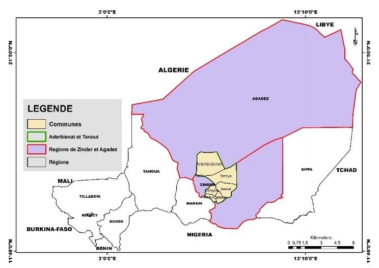
constitutes a major constraint for the sustainable 1. Urban Municipality of Tanout
development of developing countries. The Urban Commune of Tanout is located in the extreme
In Niger, this environmental problem is presented in North of the Region of Zinder and the Department of Tanout
terms of the imbalance between, on the one hand, natural (14°5 and 17°30 North latitude and 7°20 and 9°37 East
resources (soil, water, vegetation, fauna, etc.) and, on the longitude). Its population is estimated at 128,531 inhabitants
other hand, the increased needs of a rapidly growing in 2008 [4]. It is bounded to the east by the rural commune
population (3.9% /year) seeking to improve their living of Tenhya, to the west by the rural commune of Gangara, to
conditions. This situation is accelerating the degradation of the north by the rural communes of Aderbissinatt (Agadez)
forest formations at a worrying rate. Agriculture, wildfires, and Tenhya, and to the south by the rural communes of
overgrazing, woodcutting and the search for non-timber Olléléoua, Alakoss (Gouré) and Kangna Wamé (Mirriah). It
DOI: http://dx.doi.org/10.24018/ejgeo.2021.2.1.111 Vol 2 | Issue 1 | February 2021 30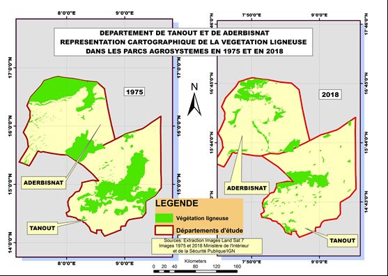
ORIGINAL ARTICLE
European Journal of Environment and Earth Sciences
www.ej-geo.org

covers an area of 6,780 km2, i.e., 20.43% of the area of the        The commune of Aderbissinat is classified as a pastoral
Department of Tanout estimated at 33,171 km2 and 4.63%           zone, but irrigated crops are gradually gaining ground.
of the total area of the Region of Zinder estimated at           Animal husbandry is practiced by most of the population of
146,170 km2.                                                     the rural commune of Aderbissinat (camels, cattle, sheep,
   Geologically, it belongs to the southern part of the          goats, asins, horses, etc.). Vegetable and cereal crops are
Iullemenden Basin. It is characterized by the following          cultivated by producers around the water points. Several
geological formations:                                           other socioeconomic activities are practiced in the commune
  - the clay plateau of Damergou in the North;                   including crafts, tourism and hospitality, trade, transport,
  - the sandstone plateau of Koutouss in the East;               etc.
  - the crystalline basement of Damagaram-Mounio in the
      South;
  - the alluvial deposits of the Tarka Valley in the West.
   Its climate is sub-desert Sahelian. The seasons,
temperatures, winds and precipitation are largely dependent
on it. Two (2) types of winds are largely dominant in the
Urban Commune of Tanout, namely harmattan and
monsoon. The vegetation cover of the commune is mainly
composed of Acacia and Prosopis. There are: Faidherbia
albida, Acacia nilotica, Acacia séyal, Acacia Radiana,
Balanites aegyptiaca, etc.
   The large fauna is practically disappearing in the
municipality to make way for a residual fauna composed of
birds, rodents, reptiles and insects.
   The dominant agricultural system is rain-fed agriculture,
which is the main economic activity of the population.                            Fig 1. Location of the study area.
Livestock farming, due to the size of the commune's
                                                                 B. Methodology
livestock population and the multitude of related economic
activities, truly constitutes the second udder of the local         Climatic data (rainfall and temperature) have made it
economy. Tourism, transport, and handicrafts are also            possible to calculate the trend in rainfall and temperature
practiced in the commune.                                        over the last four decades.
   2. Rural community of Aderbissinat                               1. Sampling and dendrometric surveys
   The rural commune of Aderbissinat is located in Niger, in        The study of the vegetation in the area was conducted on
the region of Agadez, department of Aderbissinat (LN             the basis of a floristic inventory, carried out in sampling
15'37''28; LE 007'53''32). It has a population of 35,320         units (plots), arranged on transects several kilometers apart.
inhabitants [5]. It covers an area of 25,000 km 2 and is         These transects were oriented in an east-west and north-
bounded to the south by the communes of Tanout, Tenhiya          south direction in order to better take into account the state
and Belbéji, to the north by the communes of Agadez and          of occupation of the forest and its diversity (Fig. 3). The
Tchirozérine, to the west by the communes of Tamaya and          dimensions of the sampling units are 2500 m2 in
Ingall and finally to the east by the Rural Commune of           agrosystems (50 m 50 m) and 1000 m2 in fallow land (20 m
Tabelot [4].                                                     50 m). Within each sampling unit, all the woody species
   The commune is characterized by the cliffs of Tiguidit,       have been counted and the different dendrometric
the plains of the Irhazer, the plateaux of Tadress and           parameters recorded are:
northern Damergou and the Ergs of the Sahara.                        - The height of the trees;
   The soils are sandy-silty in the dune areas, on the               - The diameter at 20 cm from the ground for shrubs;
plateaux and plains, clayey-silt to clayey in the shallows and       - The diameter at 1 m 30 from the ground for the trees;
sandy at the level of temporary and semi-permanent pools             - The crown (average diameter);
and koris.                                                           - And the number of rejects that has been counted. In
   The climate of the area is of semi-arid Sahelo-Saharan              this study, is a reject, any subject or stem with a
type, hot and dry with temperatures exceeding 40 °C in the             diameter less than or equal to two centimeters
dry season. The prevailing wind is the Harmattan which                 (d≤2 cm);
blows from east to west almost all year round. Rainfall              - Data on stationary factors such as soil texture, terrain
varies from 200 to 250 mm/year.                                        geomorphology, plot midpoint coordinates, type of
   The woody shrub and tree resource is more concentrated              land use were also collected.
around ponds and along the koris. The most frequently               2. Phytosociological surveys
encountered plant species are the following: Panicum                In addition to the floristic surveys, phytosociological
turgidum, Cenchrus biflorus, Dactylostenium aegyptium,           surveys were carried out following the methodological
Acacia ehrenbergiana, Acacia laeta, Boscia senegalensis,         approach of brun blanc. This method of studying the
Acacia nilotica, Balanites aegyptiaca, Ziziphus mauritania,      vegetation consists in assigning to each species present in
etc.                                                             the inventory plot, a coefficient of abundance dominance. It
   Wildlife resources include guinea fowl, hares, some           allows to describe the plant communities and to understand
bustards, ravens, partridges, etc.                               the spatio-temporal organization on the quantitative and

 DOI: http://dx.doi.org/10.24018/ejgeo.2021.2.1.111                                              Vol 2 | Issue 1 | February 2021   31
ORIGINAL ARTICLE
European Journal of Environment and Earth Sciences
www.ej-geo.org
qualitative level of the constituent species. It has the They resume normal life as soon as the rainy season
advantage of drawing up the floristic list of the investigated starts again.
area and of understanding the environmental conditions ➢ Hygrophytes (Hy): plants with a very fragile aerial
through the species. The Braun-Blanquet scale is as follows: apparatus and perennial organs hidden in wet mud or
5: species covering more than 75% of the survey area, i.e. even water. This form of protection is very effective
an average coverage (RM) of 87.5%; against drought and wide temperature variations.
4: species covering between 50% and 75% of the survey ➢ Chamephytes (Ch): subligneous or herbaceous plants
area, i.e. a mean coverage (MR) of 62.5%; that cross the season with a stem that is not very
3: species covering between 25% and 50% of the survey evolved above the ground. Most of the aerial part
area, i.e. a mean coverage (MR) of 37.5%; disappears during the dry season and the recovery
2: species covering between 5% and 25% of the survey takes place with the resettlement of the rainy season.
area, i.e. a RM of 15%; ➢ Phanerophytes (Ph): perennial plants, represented by
1: species abundant to less abundant and covering less trees, shrubs, lianas and woody shrubs, whose
than 1% of the survey area, i.e. a RM of 3%; hibernating buds are carried high and thus exposed to
+: rare species and covering less than 5% of the survey the weather. In Niger, this group is subdivided into:
area, i.e. a RM of 0.5%. ➢ Nanophanerophytes (NnPh), 0.5 to 2 m high;
➢ Microphanerophytes (McPh), 2 to 8 m high;
➢ Mesophanerophytes (MsPh), 8 to 30 m high;
➢ Megaphanerophytes (MPh), greater than 30 m in
height.
Spectrum of phytogeographic types
Phytogeographic types provide information on the origin
and range of the different species in the plant groupings. The
distribution of phytogeographic types has been established
in accordance with the accepted chorological subdivisions
for Africa [11]. They are:
▪ Broadly distributed species:
➢ Cosmopolitan (Cos): species distributed in tropical
Fig 2. Vegetation sampling device. and temperate regions of the world;
➢ African-American (AA): species widespread in
3. Satellite data Africa and America;
The satellite images used are Landsat7 type images from ➢ Pantropical (Pan): species widespread in Africa,
1975 and 2018. The spatial resolution of these images is 30 America and tropical Asia;
meters, UTM zone 31 N projection with WGS84 reference ➢ Paleotropical (Pal): species distributed in tropical
ellipsoid. Africa, tropical Asia, Madagascar and Australia.
▪ Species with limited distribution on the African
C. Data processing and analysis
continent
1. Description of plant groups ➢ Tropical Afro-Malagasy (AM): species distributed in
Life forms (biological types) Africa and Madagascar;
They were defined by Raunkiar according to the position ➢ Afro-Tropical (AT): species widespread in tropical
of the buds and the size of the individuals [6]. The Africa;
determination of the forms of plant adaptations ensures a ➢ Pluri-regional (PA): species whose range extends to
better appreciation of the ecological conditions in which several regional centers of endemism;
they evolve [7].These biological types, by their distribution, ➢ Sudano-Zambezian (SZ): species distributed in both
faithfully reflect the ecological conditions of a region and the Sudanian and Zambezian regional centers of
their study gives an idea of the vegetation of a given area endemism;
[8]. In this work, the classification of [6] for the study of ➢ Guineo-Congolese (GC): species distributed in the
intertropical plant formations according to [9]; [10] has been Guinean region.
adopted. It consists of: ▪ Base element
➢ Therrophytes (The): annual plants whose perenniality Sudanian (S): species widely distributed in the regional
is ensured by seeds or spores. center of the Sudanese endemism.
➢ Hemicryptophytes (H): perennial plants whose survival
buds are protected by the soil. The aerial apparatus is D. Satellite Images
herbaceous and disappears for the most part at the The image processing was carried out following several
threshold of the bad season. geometrical and radiometric corrections. Bands 5; 4 and 3
➢ Geophytes (Ge): plants with a very fragile aerial were used for the color composition because they better
apparatus and perennial organs hidden in the earth characterize the vegetation cover. The classification,
(geophytes). Geophytes are subdivided according to supervised by the maximum likelihood algorithm, was used
the type of organ into: rhizomatous geophytes (Gr), on the basis of the acquired terrain recognition.
bulbous geophytes (Gb) and tuberous geophytes (Gt). The results of the verification test give the confusion
matrices that compare the cartographic results with the data
DOI: http://dx.doi.org/10.24018/ejgeo.2021.2.1.111 Vol 2 | Issue 1 | February 2021 32ORIGINAL ARTICLE
European Journal of Environment and Earth Sciences
www.ej-geo.org
collected in the field. Overall accuracy is measured by the
Kappa coefficient [12]-[15]. The Arc Map 10.5 software
was used for image analysis.
III. RESULTS
A. Climatic Evolution
The average temperature from 1985 to 2019 is 27.3° with
an annual evolution of 0.008 °C. The trend in the evolution
of precipitation since 1985 is relatively increasing. A series
of surplus years is observed from 1997 onwards.
The average rainfall of the 1985-2019 series of
Aderbissinat is 92.5 mm. In terms of climatic evolution, the
two study communes have the same characteristics.
Fig. 5. Mapping of the occupation of woody vegetation from 1975 and 2018 in
Tanout and Aderbissinat.
C. Floral Composition
The floristic inventory of the vegetation made it possible
to identify a total of twenty-seven (27) woody species
distributed between the commune of Tanout and
Aderbissinat.
1. Commune of Tanout
Eleven (11) woody species were recorded in the rural
commune of Tanout (Table 1), divided into 7 families, the
most important of which are the Fabaceae-Mimosoideae
(45.45%). The other no less important families are
Anacardiaceae, Asclepiadaceae, Balanitaceae, Caparaceae,
Fig 3. Evolution of rainfall in Aderbissinat.
Combretaceae and Rhamnaceae, with 9.09% each.
TABLE 2: FLORISTIC LIST OF WOODY SPECIES RECORDED IN THE
COMMUNE OF TANOUT
Frequencies
Species TB TP Families Number
(%)
Acacia Fabaceae-
McPh S 1 9,09
nilotica Mimosoideae
Acacia Fabaceae-
McPh S 1 9,09
radiana Mimosoideae
Acacia Fabaceae-
McPh Pal 1 9,09
senegal Mimosoideae
Balanites
McPh SZ Balanitaceae 1 9,09
aegyptiaca
Boscia
McPh S Caparaceae 1 9,09
senegalensis
Faiderbia Fabaceae-
Fig 4. Evolution of rainfall in Tanout. Source: Agrhymet 2020. McPh PA 1 9,09
albida Mimosoideae
Guiera
NnPh SZ Combretaceae 1 9,09
senegalensis
B. Evolution of Vegetation Cove Leptadenia
McPh SZ Asclepiadaceae 1 9,09
As observed in the field, the results of the occupancy pyrotechnica
Prosopis Fabaceae-
maps show a regressive trend in the area of vegetation cover McPh i 1 9,09
juloflora Mimosoideae
in both zones (Table 2). This regressive trend is Sclerocaria
MsPh S Anacardiacea 1 9,09
characterized by an unprecedented degradation of woody birrea
Ziziphus
vegetation (Fig. 5). Indeed, over a period of forty-three McPh Pal Rhamnaceae 1 9,09
mauritiana
years (43 years) the loss of vegetation cover amounts to Total = 11 11 100,00
20.16% in Tanout and 10.27% in Aderbissinat).
2. Commune of Aderbissinat
TABLE 1: AREAS OF OCCUPATION OF WOODY VEGETATION IN THE YEARS In this municipality, 16 woody species have been
1975 AND 2018
Superficies Lost superficies inventoried (Table 2), which are divided into 10 families,
Communes Year the most important of which are the Fabaceae-Mimosoideae
(ha) (ha)
1975 1004466,62 (37.5%). The other no less important families represent each
Tanout 781797,738
2018 222668,88
1975 589924,874
6.25% respectively.
Aderbissinat 60588,034
2018 529336,84
DOI: http://dx.doi.org/10.24018/ejgeo.2021.2.1.111 Vol 2 | Issue 1 | February 2021 33ORIGINAL ARTICLE
European Journal of Environment and Earth Sciences
www.ej-geo.org
TABLE 3: FLORISTIC LIST OF WOODY SPECIES RECORDED IN THE respectively equal to 31.25%, followed by species of
COMMUNE OF ADERBISSINAT
paleotropical type (18.75%). These are followed by species
Frequencies
Species TB TP Families Number of multi-regional, introduced, and cosmopolitan type in
(%)
Acacia
McPh SZ
Fabaceae-
1 6,25
proportions respectively equal to 6.25%.
ehrenbergiana Mimosoideae
Fabaceae-
Acacia laeta McPh PA 1 6,25
Mimosoideae
Fabaceae- SZ 31,25
Acacia nilotica McPh S 1 6,25
Mimosoideae
Phytogeograghic types
Fabaceae- S
Acacia radiana McPh S 1 6,25 31,25
Mimosoideae Cos
Balanites
McPh Pal Balanitaceae 1 6,25 Pal 18,75 i
aegyptiaca
Boscia PA
McPh SZ Capparidaceae 1 6,25 PA 6,25
senegalensis
Calotropis Pal
McPh Pal Asclepiadacea 1 6,25
procera i 6,25
Commiphora S
McPh SZ Burseraceae 1 6,25
africana Cos 6,25 SZ
Cordia sinensis nP SZ Boraginaceae 1 6,25
Euphorbia 0 10 20 30 40
McPh Cos Euphorbiacea 1 6,25
balsamifera Frequencies
Faidherbia Fabaceae-
McPh PA 1 6,25
albida Mimosoideae
Leptadenia Fig. 7. Proportions of phytogeographic types.
pyrotechnica
McPh SZ Asclepiadacea 1 6,25 SZ = sudano-zambézian; S = sudanian; Pal = palaeotropical;
Maerua PA = multi-regional; i = introduced ;Cos = cosmopolitan.
McPh SZ Capparaceae 1 6,25
crassifolia
Prosopis Fabaceae- 3. Scheduling of statements
McPh i 1 6,25
juloflora Mimosoideae
The dominance abundance matrix of the
Sclerocaria
MsPh S Anacardiaceae 1 6,25 phytosociological surveys was subjected to a
birrea
Ziziphus
McPh Pal Rhamnaceae 1 6,25 correspondence factor analysis. This allowed the similarity
mauritiana threshold of 62.5% to obtain four (04) plant groupings (Fig.
Total = 16 16 16 100 8). Grouping G1 composed of eight (08) species, grouping
G 2 composed of two (02) species, grouping G 3 composed
D. Description of the Biological and Phytogeographic of five (05) species and grouping G 4 composed of only one
Types of Plants (01) species.
1. The biological types E. Dendrometric Parameters
The results in Fig. 6 show the proportions of the PCA
Information Remaining (%)
biological forms of the woody species inventoried in the 100 75 50 25 0
area. Analysis of these results shows that Acacnilo
Caloproc 4
microphanerophytes dominate (86.67%) followed by Acacradi 1
Maercras 3
mesophanerophytes and nanophanerophytes in proportions Balaaegy 8
12
Zizimaur
respectively equal to 6.66%. Faidalbi
Prosjuli
Euphbals
Sclebirr
Acacsene
Bauhrufe
Guiesene
Lepthast
MsPh 6,66 Bosssene
Leptpuro
Fig. 8. Dendrogram of plant groupings.
Biologic types
NnPh 6,66
IV. DISCUSSION
Since climatic fluctuations influenced mainly by rainfall
McPh 86,67 are insignificant, the dynamics of vegetation lies in
anthropogenic pressure. The armed insurrections of the
1990s and the residual banditry since the destabilization of
0 20 40 60 80 100 Libya in 2011 have led to a concentration of herds in the
Frequencies(%) southern Air Mountains where the plains abound in
Fig 6. Proportions of biological types. relatively abundant pasture. Also, before the great drought
McPh = microphanérophytes; MsPh = mésophanérophytes; of 1973, most transhumance was oriented towards the north,
NnPh = nanophanérophytes. where the pastoral zone is located [16]. This phenomenon
contributed to overexploitation of the wood resource (Fig.
2. Phytogeographical types 5), with a loss of vegetation cover of 20.16% in Tanout and
The results in Fig. 7 illustrate the proportions of 10.27% in Aderbissinat over a period of 43 years. This
phytogeographic types. These results show that the Sudano-
Zambezian and Sudanian species dominate, with proportions
DOI: http://dx.doi.org/10.24018/ejgeo.2021.2.1.111 Vol 2 | Issue 1 | February 2021 34ORIGINAL ARTICLE
European Journal of Environment and Earth Sciences
www.ej-geo.org
situation is present in several West African countries [17]- V. CONCLUSION
[19]. The establishment of the diachronic map (1975-2018) of
A. Floristic Characteristics of the Area land occupation in the northern areas of Tanout and
The flora richness, which reflects the structure and Aderbissinat, allowed us to show the dynamics of
continuous degradation of the vegetation cover. This
functioning of plant communities, is the biological indicator
pastoral area is nowadays completely colonized by
most often used to assess the state of an ecosystem. State
that any increase in floristic richness can be the cause of a herbaceous and woody species not relished by animals and
which are indicators of the protrusion of the desert front.
process of self-restoration of a degraded ecosystem [20].
The contribution of this study lies in highlighting changes in
The results on species richness in this study are significantly
lower than those obtained by [21] in the natural and post- use of land, thus showing the need to set up a more efficient
management system of the natural resources in the area for
cultural formations of the classified forests of Dan Kada
Dodo-Dan Gado. These prove that the ecosystems of the the well-being of the population of the area.
northern zone of Niger are highly degraded. The low
floristic composition of the zone testifies to the strong
REFERENCES
presence of anthropic factors which significantly disturb the
functioning of these ecosystems. They constitute, therefore, [1] N’da, D., et al., Analyse de la diversité floristique du parc national de
la Marahoué, Centre-Ouest de la Côte d’Ivoire. Afrique Science:
the main factors that lead to a modification in the floristic Revue Internationale des Sciences et Technologie, 2008. 4(3).
composition and structure of vegetation [22]. The woody [2] Hountondji, Y.-C.H., Dynamique environnementale en zones
flora of these sites remains dominated by Fabaceae- sahélienne et soudanienne de l’Afrique de l’Ouest: Analyse des
modifications et évaluation de la dégradation du couvert végétal.
Mimosoideae and Combretaceae. Individuals from these two Belgique: Université de Liège, 2008.
families now colonize Sahelo-Sudanian ecosystems through [3] FAO, Evaluation des ressources forestières mondiales 2010. Rapport
several mechanisms of dissemination (zoochory, principal. Etude FAO. Forêts n° 163, Rome, Italie, 2010: p. 348 p.
[4] PDC, Plan de développement communautaire de la commune rurale
anthropochory and anemochory). The two families de Guéchémé. 2014. p. 119P.
mentioned above are indicative of a generally dry and arid [5] RGP, Recensement Général de la Population et de l'Habitat, 4ème
climate [23]. Série. 2012.
[6] Raunkiaer, C., The life forms of plants and statistical plant geography;
The analysis of the biological types gives an idea of the being the collected papers of C. Raunkiaer. The life forms of plants
dynamics of a phytocenosis [24]. The predominance of and statistical plant geography; being the collected papers of C.
microphanerophytes in the Sahelian zone has also been Raunkiaer., 1934.
[7] Koechlin, Y. and A. Pascal, The speed of response of the 56 AVP
noted by several authors [25], [26]. It results from these
photomultiplier and its measurement in the laboratory. 1961, Centre
observations that the privileged position of these plant d'Etudes Nucleaires, Saclay, France.
families is based on an optimal composition strategy [8] Mahamane, L. and S. Mahamane, Biodiversity of ligneous species in
including longevity, large size and ecological tolerance [27]. semi-arid to arid zones of southwestern Niger according to
anthropogenic and natural factors. Agriculture, ecosystems &
The phytogeographic type remains dominated by Sudano- environment, 2005. 105(1-2): p. 267-271.
Zambezian (SZ) species. They constitute a biological [9] Natta, A., B. Sinsin, and L. Van Der Maesen, A phytosociological
indicator that provides information on the dynamism or study of riparian forests in Benin (West Africa). Belgian Journal of
Botany, 2003: p. 109-128.
stability of plant communities [28]. These results thus [10] Rohlf, F.J. and G.D. Schnell, An investigation of the isolation-by-
obtained corroborate those of several authors [14]. distance model. The American Naturalist, 1971. 105(944): p. 295-
In Niger and in the rest of the world, rainfall recession has 324.
[11] White, J.G., et al., The structure of the nervous system of the
been observed [29]-[31], with deficits since the 1970s and nematode Caenorhabditis elegans. Philos Trans R Soc Lond B Biol
1990s and changes in agro-ecological zones in West Africa Sci, 1986. 314(1165): p. 1-340.
[32]. In the north (Aderbissinat and Tanout) of Niger, as [12] Perrenoud, P., Mobiliser ses acquis: où et quand cela s' apprend-il en
formation initiale? De qui est-ce l'affaire? Recherche & formation,
shown in Figure 3, the evolution of rainfall between 1975 2000. 35(1): p. 9-23.
and 2018 remained relatively constant with wet years [13] Sissako, A., et al., Bamako. 2007: Trigon-film.
recording more than 80 mm (1990, 1993, 1997). In all cases, [14] Inoussa, M.M., et al., Dynamique spatio-temporelle des forêts claires
dans le Parc national du W du Niger (Afrique de l’Ouest). Science et
annual rainfall remains globally below 60 mm per year. The
changements planétaires/Sécheresse, 2011. 22(2): p. 108-116.
climatic fluctuation with the average temperature from 1985 [15] Young, R.M., et al., Identification of human semiochemicals
to 2019 which is 27.3 °C, an annual evolution of 0.008 °C attractive to the major vectors of onchocerciasis. PLoS Negl Trop Dis,
and the rainfall trend mentioned above allow us to conclude 2015. 9(1): p. e3450.
[16] Bassett, T.J., C. Blanc-Pamard, and J. Boutrais, Constructing locality:
that the dynamics of the vegetation cover lies in the The terroir approach in West Africa. Africa, 2007: p. 104-129.
anthropic pressure in view of the climatic fluctuations [17] Bodart, C., et al., Contribution of SAR interferometry (from ERS1/2)
influenced mainly by rainfall which is insignificant. This in the study of aeolian transport processes: the cases of Niger,
Mauritania and Morocco, in Desertification and risk analysis using
corroborates the results of several authors who have worked high and medium resolution satellite data. 2009, Springer. p. 129-136.
on vegetation dynamics [26]. Numerous dead plants were [18] Bodart, C., A. Ozer, and D. Derauw, Suivi de l’activité des dunes au
recorded, the species most concerned being the families Niger au moyen de la cohérence interférométrique ERS 1/2. Bulletin
de la Société Géographique de Liège, 2010. 54(1): p. 123-136.
Fabaceae-Mimosoideae followed by Balanitaceae. This [19] Hountondji, Y.-C., et al., Ongoing desertification processes in the
mortality is due to anthropogenic causes and to the effects of Sahelian belt of West Africa: an evidence from the rain-use
aridity in the study area, reducing the availability of useful efficiency. Recent advances in remote sensing and geoinformation
processing for land degradation assessment. London: Taylor Francis
water and nutrients and limiting the physiological Group, 2009: p. 173-186.
functioning of plants [33]-[35]. [20] Kallali, H., et al., GIS-based multi-criteria analysis for potential
wastewater aquifer recharge sites. Desalination, 2007. 215(1-3): p.
111-119.
DOI: http://dx.doi.org/10.24018/ejgeo.2021.2.1.111 Vol 2 | Issue 1 | February 2021 35ORIGINAL ARTICLE
European Journal of Environment and Earth Sciences
www.ej-geo.org
[21] Abdourhamane, H., et al., Potential germination and initial growth of Nouhou Ali, PhD, Lecturer and researcher at the
Sclerocarya birrea (A. Rich.) Hochst, in Niger. Journal of Applied Abdou Moumouni University of Niamey in the
Biosciences, 2014. 76: p. 6433-6443. Department of Geography, Research Laboratory
[22] Yorou, S., et al., Diversité et productivité des champignons Sahelo-Saharan Territories. Specialized in the teaching
comestibles de la forêt classée de Wari-Maro (Bénin, Afrique de of climatology and problems related to climate change.
l'Ouest). Systematics and Geography of Plants, 2001: p. 613-625.
[23] Mbayngone, E., et al., Magnoliophyta of the partial faunal reserve of
Pama, Burkina Faso. Check List, 2008. 4: p. 251.
[24] Babatounde, S., et al., Valeur alimentaire des fourrages consommés
par les taurillons Borgou sur les parcours naturels du centre du Bénin.
International Journal of Biological and Chemical Sciences, 2011.
5(6): p. 2382-2394. Minoungou Bernard, hydrologist at the regional
[25] Mahamane, A., Usages des terres et évolutions végétales dans le agrhymet center.
département de Maradi. Vol. 27. 2001: Drylands Research His role is to carry out data analysis and hydrological
Crewkerne, UK. modelling to define and quantify the dominant hydro-
[26] Mahamane, A., S. Mahamane, and J. Lejoly, Phénologie de quelques meteorological processes in the main river basins of
espèces ligneuses du parc national du «W» du Niger. Sécheresse, West Africa in order to implement tools for
2007. 18(4): p. 354-358. hydrological forecasting, information production on water resources,
[27] Grime, J.P., Evidence for the existence of three primary strategies in climate change and early warning. Part of his work is to collect better
plants and its relevance to ecological and evolutionary theory. The quality hydroclimatic data, to improve climate products, to contribute to
american naturalist, 1977. 111(982): p. 1169-1194. building the capacities of the staff of the West African national hydrology
[28] Sinsin, A.B., Phytosociologie, écologie, valeur pastorale, production and meteorology services.
et capacité de charge des pâturages naturels du périmètre Nikki-
Kalalé au Nord-Bénin. 1993.
[29] Briquet, J., et al., Changements climatiques récents et modification du
régime hydrologique du fleuve Niger Koulikoro (Mali). IAHS
PUBLICATION, 1996: p. 157-166.
[30] Kouassi, C.K., et al., Profiles of bioactive compounds of some pepper
fruit (Capsicum L.) varieties grown in Cote d'Ivoire. Innovative
Romanian Food Biotechnology, 2012. 11: p. 23.
[31] Mena, M.S., et al., Les Changements Climatiques A Travers La
Modification Du Régime Pluviométrique Dans La Région De Kribi
(1935-2006). Rev. Ivoir. Sci. Technol, 2016. 28: p. 389-407.
[32] Diouf, D. and O. Boiral, The quality of sustainability reports and
impression management. Accounting, Auditing & Accountability
Journal, 2017.
[33] FAO, Amenagement des forets naturelles des zones tropicales seches.
No 32. Rome : FAO., 1997.
[34] Adjonou, K., R. Bellefontaine, and K. Kokou, Les forêts claires du
Parc national Oti-Kéran au Nord-Togo: structure, dynamique et
impacts des modifications climatiques récentes. Sécheresse, 2009.
20(1): p. 1-10.
[35] Diallo, M.S., N.A. Fromer, and M.S. Jhon, Nanotechnology for
sustainable development: retrospective and outlook, in
Nanotechnology for Sustainable Development. 2013, Springer. p. 1-
16.
Sina Abdoul Kader Soumaila, PhD Student at the
Doctoral School of Abdou Mounmouni University,
Holder of a Master2 in Natural Resources
Management and Biodiversity of the University of
Abomey Calavi at the Laboratory of Applied
Ecology of the Faculty of Agronomy, promoter of
the Office of Studies in Environmental Management
and Cartography (BEGEC International). It should be
noted that SINA is the Environmental and Social
Expert of the Trans-Saharan Fiber Optic Backbone
Project (DTS Niger/African Development Bank (BAD) funding) and as
such is in charge of safeguarding the project in its activities. To have
carried out several environmental studies for projects (financed by the
World Bank) and national and international private promoters.
Garba Amadou, Water and Forestry Engineer.
Assistant to the Biophysical Observations and
Cartography Division (D.O.B./C) at the National
Center for Ecological and Environmental Monitoring
(C.N.S.E.E.). PhD student in plant biology and
ecology at the doctoral school of life and earth
sciences (S.V.T) of the Abdou Moumouni University
of Niamey.
DOI: http://dx.doi.org/10.24018/ejgeo.2021.2.1.111 Vol 2 | Issue 1 | February 2021 36You can also read