HIGH CARBON STOCK APPROACH - HCSA PEER REVIEW REPORT Company Name: Goodhope Holdings
←
→
Page content transcription
If your browser does not render page correctly, please read the page content below
HIGH CARBON STOCK APPROACH

                    HCSA PEER REVIEW REPORT

                  Company Name: Goodhope Holdings
HCS Assessment Area: PT. Agro Wana Lestari & PT. Karya Makmur Sejahtera
                            09 August 2019

                                                                          1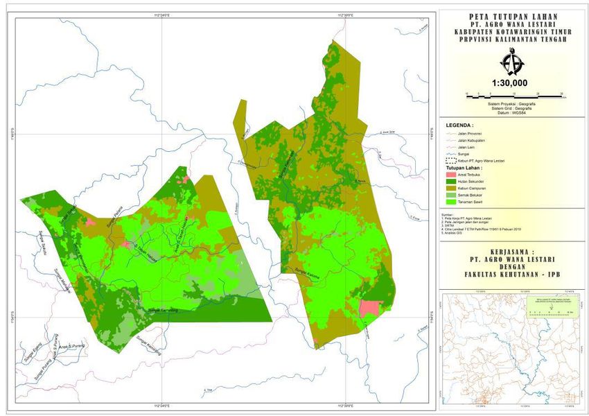
Background information:

   a) Did a Registered Practitioner Organisation lead the HCS assessment? If not, has the organisation which led the assessment started the process
      of registration?
      Yes, Ata Marie which led the HCS assessment is a Registered Practitioner Organisation.

   b) Was the HCS Team Leader a Registered Practitioner?
      Yes, Alex Thorp who is the HCS Team Leader is a Registered Practitioner under Ata Marie.

   c) Were at least two (2) HCS team members Registered Practitioners?
      Yes, at least two HCS team members are Registered Practitioners. They include Alex Thorp, George Kuru, Dadan Setiawan and Dadi Ardiansyah.

   d) Was the HCV assessment judged ‘satisfactory’ (highest rating) by the HCV Resource Network (HCVRN) Assessor Licensing Scheme (ALS)?
      (See https://www.hcvnetwork.org/als/public-summaries).
      The PT. Agro Wana Lestari & PT. Karya Makmur Sejahtera HCV reports were prepared in 2011 i.e. prior to existence of HCVRN. Subsequently (after
      Goodhope joined RSPO in 2014) the two companies submitted NPP applications to RSPO.

                                                                                                                                                      2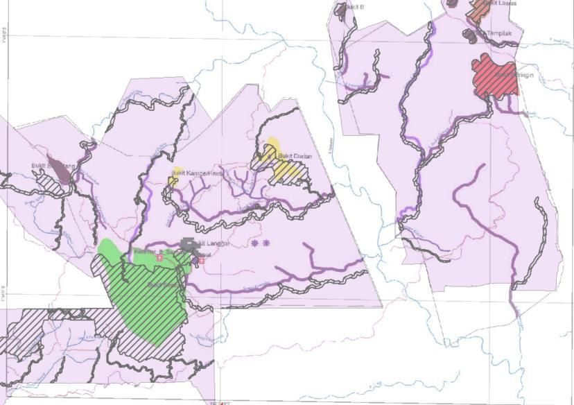
Questions for peer reviewers
                                                            (Peer Review Panel: Jules Crawshaw)

1.      Peer Review Summary
1.1.    What are the major findings and recommendations from the peer review?

Finding:
In general, this is a good piece of work. However, the fact that only a summary report, not the full HCS report, has been provided means that it was
difficult to review because it lacked detail.

The HCV report and the HCV areas that were delineated lacked strong justifications. It appears that the landscape has changed considerably since the HCV
report was written. This meant that the HCV report, which is a major foundation of the HCS report was rather weak. Additionally, the findings of the SIA
reports and the HCV reports were quite inconsistent.

It appears that the FPIC that has been undertaken by Goodhope has serious weaknesses. This was alluded to in AM’s recommendations, which indicated
that company staff were primarily focused on acquiring new land rather than focusing on good FPIC procedure.

Reviewers Recommendation:
1. Generally Ata Marie has covered off on all issues raised by the reviewer. Clearly their task has been made difficult by the underlying HCV reports, which
need to be repeated.
2. Goodhope should revisit the HCV report. Unfortunately, this will impact on the HCS report also as the ICLUP will have to be readjusted based on a new
HCV report.
3. Goodhope needs to strengthen its procedures relating to land acquisition and grievances. Also, it appears there is a lack of good quality FPIC records,
which made AM’s job of documentation of past work very difficult. As such, documentation of FPIC needs to be a major focus for Goodhope moving
forward. A FPIC gap analysis has been done by LINKS. Unfortunately, the gap analysis report is rather vague and their methodology didn’t involve a
document review – it just relied on gathering information from stakeholder interviews. Nevertheless, it has pointed out that the FPIC that has been done
has been minimal and of questionable quality, with no monitoring of its implementation.

Company Comments:
                                                                                                                                                           3
Goodhope acknowledges the recommendation to repeat HCV assessment and adjust the ICLUP. Nonetheless, the HCSA assessment will provide useful
contributions to the development and implementation of an improved conservation management and monitoring program. A new HCV assessment will be
completed prior to any proposal for new plantings.
Our procedures relating to grievances and land acquisition have been improved and processes continue to be strengthened. We are currently developing a
new Grievance Approach in collaboration with Daemeter Consulting. Key aims include improved documentation and increased inclusivity.
1.2. Did the HCS assessment team include or have adequate access to relevant expertise to undertake the HCS assessment?
Finding:
It appeared that the way the HCS survey was executed was done professionally and following the HCS toolkit.
Reviewers Recommendation:
No recommendation.
1.3. What elements of the HCS Approach still need to be completed in order to create a final land use and conservation plan? Are there aspects which
you feel need to be re-done?
Finding:
As discussed in Section 1.1 – the HCV report needs to be redone right from the field work.
Reviewers Recommendation:
No recommendation.
Company Comments:
Well acknowledged.
42. Social Issues
2.1. Does the summary provided in Section 3.1 adequately represent and explain the community engagement, FPIC processes, and participatory
mapping activities carried out?
Finding:
There are records of community engagement, FPIC processes, and participatory mapping activities that were undertaken. The list of activities that were
done and the outputs by Ata Marie appear to be adequate.
However, information is only provided about these processes that were undertaken by Ata Marie. There is no information about the processes that were
undertaken by Goodhope. The report states that “AWL and KMS license areas was released to the Company between 2003-2006”. So, the company has
had a presence in the area for a considerable time. Some of the descriptions are couched in quite vague terms:
- regarding land acquisition “Communities indicated that land acquisition was carried out following a set procedure. In general community members were
satisfied with the procedure and felt land acquisition was carried out in a participative and transparent manner.” and “They expect better compensation
prices and better land acquisition procedures to reduce dispute of land ownership between communities.” The reviewer expects that there is a land
acquisition SOP that is followed. This should be stated clearly with the number and version. The second sentence indicates that the SOP is not clearly
understood by the community and still results in disputes.
- “No specific complaints mechanism has been agreed to between communities and company” – it appears there is no grievance mechanism SOP, if this is
the case this is a major issue that needs to be addressed.
Reviewers Recommendation:
1. Provide information about the FPIC and community engagement that has taken place in the lead up to the HCS assessment. The Community
Engagement Report provides information about the activities that were undertaken under Ata Marie’s guidance immediately prior to the assessment. The
reviewer was expecting to receive a chronology of all FPIC / Community Engagement Activities that have taken place from when Goodhope first started
activities in the area (2003-6) until the present date. This would include the date, who the meeting was with, a summary of what was discussed and the
outcome. This would be supported by detailed files with attendance lists and minutes of meetings. Without this documentation the company cannot
prove that FPIC has been implemented. Furthermore, if all discussions are purely verbal, it is likely that disputes will arise and will be difficult to deal with.
The reviewer guesses that this information is not available, therefore, a recommendation is that record keeping procedures relating to FPIC be improved
(or implemented).
52. Provide information about the land acquisition SOP, with details about how prices are derived (e.g. based on the land inventory process). The
recommendation in No.1 (above) is supported by LINKS’ FPIC gap analysis. If there was good quality documentation of the FPIC process, most of LINKS
work would be document review. Whereas they had to go out to the field and interview stakeholders to determine what activities had taken place.
Additionally the findings show that much of the socialisation was inadequate (e.g. “Pemenuhan FPIC pada aspek sosialisasi terpenuhi dengan catatan,
karena belum memadainya informasi yang disampaikan dalam sosialisasi terutama informasi tentang dampak social negatif pengembangan perkebunan
kelapa sawit (kecuali PT Agro Bukit), jumlah kredit pembangunan kebun, potongan kredit, estimasi jangka waktu pembayaran kredit, mekanisme
permintaan informasi, mekanisme penyampaian keluh kesah serta penyelesaian konflik termasuk tata cara keterlibatan masyarakat dalam kegiatan
maupun mekanisme tersebut awal terpenuhi dengan catatan perlu perbaikan.”)
3. The company must address the lack of a Grievance or Complaints SOP. LINKS made the following recommendation about SOPs at GH - “SOP-SOP
tersedia di lokasi perkebunan anak-anak perusahaan Goodhope group di Provinsi Kalimantan Tengah namun harus diterjemahkan dalam bahasa Indonesia
dan disosialisasikan dan dilaksanakan secara berkala kepada level manajemen maupun staf terkait, serta di lakukan pemantauan dan evaluasi berkala
terkait implementasinya.” Given that few of the operational staff are likely to be able understand English it is unlikely that the SOPs have been widely
consulted or implemented. The recommendation follows that of LINKS – that the SOPs are translated and socialised. Additionally, their implementation is
monitored (another of LINKS recommendations).
Company comments:
A grievance procedure for handling of complaints raised by community has been in place since 2008 (as part of Goodhope’s CSR handbook). This
procedure has since been reviewed and revised with latest version in 2018 available in Indonesian language. Further improvements are underway:
Ensuring improved monitoring processes, minutes of meetings etc. and promoting regular community forums are important parts of our new Grievance
Approach, which we are developing together with Daemeter Consulting.
62.2. Has a tenure study been completed and has it been vetted by independent social experts?
Finding:
No land tenure assessment was undertaken. Though there is some information about land tenure provided in the text.
Reviewers Recommendation:
Undertake a land tenure assessment as part of this study.
The reviewer wasn’t suggesting that “Identification of individual landowners across the whole estate” is required; rather a land tenure study is carried out.
This is defined in the “Implementation Guide for the Social Requirements of the High Carbon Stock Approach” as “The necessary information must be
collected by means of workshops held in each community, in which community members fill in details of their customary land and resource rights and use
on a prepared base map, using their knowledge of their lands and resources, and explain the underlying system they use to control, own, manage and
transfer lands and resources.”
2.3. Is there a participatory land use map and does it contain the key components of community land use including the minimum requirement of 0.5 ha
per person for future garden areas?
Finding:
There is an analysis of garden areas available which concludes that the concessions cover only 5% of the nine villages’ land area. Which on the surface
seems as if there is no problem with land requirements being met. However, the assessor points out that “Some Desa land has been released to other oil
palm companies, so the actual available area may be less. The accuracy of this assessment would also be improved by including analysis of the suitability of
the residual land, but this is outside the scope of this assessment. Spatial data available is insufficient to make detailed analysis of this.”
This basically means this calculation could be easily manipulated to make it look like there is no problem with land requirements. Particularly by not taking
into account areas that are unavailable for agriculture (e.g. owned by other OP companies or are not suitable such as lakes, swamps and steep areas).
Reviewers Recommendation:
Not so much a recommendation for the assessor, but a recommendation for HCS. A protocol needs to be agreed upon for undertaking this area availability
analysis so that a meaningful result comes out of it.
72.4. Is there a record of consultation with affected communities and FPIC processes on the proposed development, the HCS Approach and
issues/concerns they raised? Did the community nominate their own representatives?
Finding:
There are records of consultation with the affected communities and there are records of the FPIC process that were undertaken by Ata Marie. The FPIC
process that were undertaken by Ata Marie appear adequate.
Regarding the community nominating their own representatives; most communities are represented by the Kepala desa and the BPD, but in the SIA1 it is
stated “Some village people recognize their village chief and some others do not recognize their village chief and all of his decision made.” Additionally, in
the SIA it is stated “Kurang berfungsinya peran BPD sebagai sarana warga untuk tempat bermusyawarah antar warga perihal rencana pemerintahan desa
dalam mengambil semua keputusan terkait pembukaan lahan oleh perusahaan kebun PT. Agro Wana Lestari.” These statements cause concern and should
really be addressed in detail in the report, clearly stating who represented the community and ensuring they did have the mandate to do so. The reviewer
accepts that it makes it difficult as the company cannot really involve itself in the functioning of the village.
Another indication that the FPIC was lacking was the recommendation in the AWL SIA “Perlu segera dilaksanakan sosialisasi tentang rencana kegiatan
perusahaan kepada seluruh masyarakat, terutama masyarakat yang lahan garapannya berada pada areal izin PT. AWL. Saat kajian ini dilaksanakan,
sosialisasi baru dilaksanakan kepada aparat desa dan tokoh masyarakat.” This seems to indicate that the FPIC has been rather lacking in the past.
Reviewers Recommendation:
1. Provide additional information on the FPIC activities that were undertaken prior to AM’s engagement. Section 4.1 of the LINKS report provides
information on the FPIC activities that have taken place to date. The LINKS report definitely lacks detail and the method only involved interviews, there
was no document review element described. As such, the information this report provides is extremely general.
2. Provide additional information on Goodhope’s policies and procedures e.g. land acquisition. No SOPs have been provided for review.
3 From what the reviewer can ascertain from the LINKS report and AM report. There is a grievance procedure, it is not written in Bahasa Indonesia and
grievances tend to be dealt with informally (“In practise, communities generally deliver their complaint directly to company management or through
village leaders, and the company will usually discuss any issues via village leaders.”) Therefore, it appears the procedure is not very closely followed.
4. Provide more information about who represented the community and how the assessors felt confident that these people had the authority to do so
1
Unfortunately, the AWL SIA has no date on it.
8(based on the quoted sentence from the SIA).
5. The reviewer, based on the information provided, concurs with AM’s own recommendation that the Goodhope GRTT procedures need to be improved.
Company Comments: As in 2.1
2.5. Were their views addressed and reflected in the plans and implementation of the plantation? Is there specific reference to the customary owners
being made aware that they can say no to the development and they have the right to independent legal representation with regard to their
agreements before they sign (to meet the ‘prior informed’ test)?
Finding:
In the consultations with the community AM has mentioned that the customary owners had been made aware that they can say no to the development.
AM states that they are “free to engage external parties to act as community representatives at any stage of the assessment process.” This could mean
independent legal representation.
In the SIA it was mentioned in every village interview “Terjadi beberapa kasus land clearing lahan pada lahan yang dianggap oleh masyarakat belum selesai
proses ganti ruginya.” For this reason, there really needs to be a lot more information provided about FPIC, the grievance process and how these issues
were resolved.
Reviewers Recommendation:
1. There is no description provided of Goodhope’s land acquisition policy and procedure. However, in the LINKS report it is stated that “sehingga tidak
terdapat dokumentasi proses negosiasi.” So there are no records or documentation of negotiation. Furthermore, LINKS states that “belum memiliki
mekanisme monitoring dan evaluasi pelaksanaan FPIC, karena memang rencana kegiatan monitoring dan evaluasi ini tidak pernah dibahas sebelumnya
dengan para penyerah lahan maupun pemerintah desa setempat. Kegiatan pemenuhan FPIC di kedua perusahaan berakhir pada proses penyerahan lahan
oleh masyarakat, pembayaran GR/GRTT yang kemudian dilanjutkan dengan pembangunan oleh perusahaan. Adapun masalah berupa keluhan maupun
konflik yang muncul setelah proses penyerahan lahan dan pembangunan kebun direspon penyelesaiannya berdasarkan standar maupun prosedur yang
kemudian disusun oleh manajemen perusahaan, bukan sebagai satu kesatuan rencana dan implementasi pemenuhan FPIC.” From this the reviewer
surmises that there were no checks and balances in the process to ensure SOPs were being correctly applied.
Company Comments: As in 2.1
92.6. What recommendations do you have for any improvements regarding community consultation and negotiation of Free, Prior and Informed
Consent?
Finding:
All covered in the previous sections.
Reviewers Recommendation:
No recommendations.
103. Ecological and Conservation Values
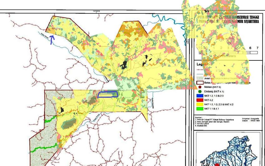
3.1. Does the summary provided in Section 4.1 of the Summary Report adequately represent the findings of the HCV study?
Finding:
A review was done against the HCV areas mapped in the 2 IPB HCV reports and the areas mapped by AM.
There seems to be large differences between the IPB HCV areas (solid colour) and the AM HCV (hashed) areas. E.g. rivers are mapped as HCV in one
version and not the other (and vice versa). The shape of the HCV around Bukit Sentuai is completely different. Additionally the classifications seem to have
changed e.g The green area on Bukit Sentuai is classified by IPB as HCV 1.2, 1.3, 2.3, 3 , 4.2 and 6, whereas AM classifiy these as HCV HCV 1.2, 1.3, 2.3 and
4.2.
11Company Response:
Separate HCV assessments were made for each company by IPB. There were a number of issues relating to the HCV reports:
1. The study areas overlapped in some areas. HCV data in the reports where there was overlap was not consistent, particularly HCV 4.1. (rivers and
buffers), but also other HCV areas.
2. Some areas were not covered by either of the HCV studies.
3. There were numerous rivers which were incorrectly not mapped in the HCV reports (it seems Assessors used very poor quality secondary data for this
purpose, and did insufficient verification). When we carry out patch analysis we combine HCV and HCS data so we need reliable riparian reserve mapping
otherwise the result is not implementable. Finally, we decided to correct the river lines and adjust buffers to match.
3. The final product represents a rework of a messy spatial dataset. No HCV areas have been dropped – just moved. In fact, we added a few more
streams. Ata Marie instructed Goodhope to revise their internal HCV management and monitoring plans to reflect the updated dataset.
Reviewers Recommendation:
Provided GH follows AM’s recommendations (refer to company’s response as above), the response is adequate. However, in retrospect, it probably would
have been better to undertake an integrated assessment so the HCV and HCS results are harmonised. Currently, as noted by AM, the rework of the HCV
dataset is not good.
Company Comments:
The HCSA assessment provides useful contributions for the development and implementation of an improved conservation management and monitoring
program. A new HCV assessment will be completed prior to any proposal for new plantings.
123.2. If the HCV assessment was not judged satisfactory (highest rating) by the ALS scheme of the HCVRN (as noted in the introductory information from
the HCS Secretariat – please see page one of this document), please do a cursory review of the HCV report as it relates to HCVs 1-4. Do you have
any general comments on the quality of the site description, the analysis of the landscape and national or regional context, or the methods used to
undertake the HCV study? Were the determinations of the absence/presence and extent of HCVs 1-4 well-justified? Are the HCV management and
monitoring maps accurate?
Finding:
In the AWL report the following land cover map was provided.
- HCV 1 – This shows there are extensive areas of forest remaining in the area. This combines with the flora survey shows that there are many species (>20
species) that are rated IUCN VU or above. Along with the presence of flagship mammal species such as orangutans. However only relatively small areas
were classified as HCV.
- HCV 2.3 – is identified on an area of 285 ha. Which would be insufficient to maintain a population of representative populations of most naturally
13occurring species, however, no attempt has been made to map the HCV outside the concession to give the reviewer confidence that it is not just that area
that is being mapped as HCV 2.3.
- HCV 3 – there is no analysis of rarity (beyond declaring the karst areas as HCV 3) or whether the extant ecosystems are endangered.
- HCV 4.1 – many rivers are mapped, however table IV-5 provides buffers of different widths. There is no discussion or justification of these widths. Many
buffers are 15 or 25 m which contradicts Keputusan Presiden No 32/1990 and PP No 38/2011. This law requires the maintenance of buffer zones of at least
100m on both sides of ‘large’ rivers, and 50m on ‘small’ rivers. No minimum size of a river requiring a buffer is stipulated in the law.
HCV 5 – The SIA for AWL states a negative impact of the development as “Availability of hunting fields and areas for gathering forest products were
reduced.” From this one would assume there are areas where people hunt and gather NTFPs; yet there are no HCV 5 areas identified in the HCV report and
in the level of dependency table hunting and gathering of NTFPs is hardly even mentioned.
There seem to be a lot of inconsistencies in the HCV report.
Reviewers Recommendation:
Goodhope should consider repeating the HCV assessments. Particularly given that the forest cover has been reduced considerably between the time of the
HCV report and the HCS assessment.
Company Comments:
The HCSA assessment provides useful contributions for the development and implementation of an improved conservation management and monitoring
program. A new HCV assessment will be completed prior to any proposal for new plantings.
3.3. Please review Section 9.2 of the Summary Report. Was the methodology used for the Pre-RBA and the Rapid Biodiversity Assessments (if any)
satisfactory? Did the RBA(s) reveal any significant biodiversity values that should have been captured in either the HCV assessment but were not,
or warrant protection?
Finding:
The report which has been uploaded shows that the pre-RBA and RBA checks have been followed correctly.
Reviewers Recommendation:
No recommendations.
143.4. Are the forest conservation management and monitoring activities outlined in Section 10.3 adequate? Do they take into account forests and
protected areas outside the concession?
Finding:
The reviewer overlaid the current landcover on the final HCV map provided by IPB. The reviewer found many areas that were mapped as HCV 1.2 and 1.3
appear to have been converted to OP. See blue polygon below. This raises questions about the forest conservation measures that have taken place to date
if HCV areas have been converted to OP.
Two threats are listed, these are:
1. Clearing of land for smallholder agriculture development.
2. Uncontrolled felling of trees for timber.
However several times in this report the damage to the forests in the area by fires are mentioned. It seems strange that this is not listed as a threat.
Furthermore, the community don’t have the tools or training to fight fires and usually look to the company to provide resources.
15Additionally, in the SIA, threats to environmental services which are perceived by the community are:
1. Pollution of river water for drinking by runoff from plantations and agri-chemicals.
2. Pollution of river water for drinking by illegal gold mining activities.
Neither of these are mentioned as threats.
Company Responses: There are many mapping issues around the old HCV reports. A historical land cover change assessment is required to get to the
bottom of the potential historical HCV clearance issue. This is beyond the scope of this report.
Reviewers Recommendation:
There should be justification provided as to why areas that were mapped as HCV 1.2 and 1.3 are now OP. Although the reviewer accepts this will have
occurred before AM’s involvement. However, some background to this serious issue must be provided.
As pointed out by AM (refer to Company’s response above), the problems stem from the HCV reports, which “is” outside the scope of the HCS report.
Company Comments:
The company has completed land use change analysis up until the date of the HCV assessment. We are currently seeking to appoint an independent
consultant to extend the land cover assessment. Furthermore, the outcome of the HCSA assessment will be used to improve conservation management
and monitoring processes, including better addressing threats.
164. Image Analysis
4.1. Please review Section 6.1 of the Summary Report. Was the Area of Interest correctly identified?
Finding:
Section 6.1 of the AM report states the AOI to be “The AWL and KMS total HCS Study area covers 24,782 ha.” However, the toolkit describes:
“The Area of Interest (AOI) to be mapped must include the concession and also the broader landscape adjacent to the concession. This is because the
classification is conducted using relative amounts of canopy cover and carbon stock calculations within a landscape context. For instance, forest patches in
a concession that is highly degraded with minimal presence of potential HCS will need to be compared to other larger forest landscapes outside of the
concession in order to place them in context. The boundary of the AOI must be aligned to either administrative or natural boundaries, for instance
hydrological catchments or other landscape units. Rationale for the determination of the boundary must be provided.”
However, the GIS dataset provided maps forest / non-forest 5 km from the boundary.
Reviewers Recommendation:
It appears that the AOI has been defined as 5 km from the boundary (which the reviewer considers to be adequate). Therefore, the wording in section 6.1
should be updated.
However, it is not clear whether the external area of patches of forest that bridge the concession boundary have been taken into account in the patch
analysis. The dataset provided seems to be clipped to the concession boundary. Some description of the process of dealing with this wider AOI is
required.
Company responded that: “Although data provided was clipped at concession level, the patch analysis process included analysis of connectivity to external
forest areas, as described in the toolkit.” The reviewer accepts this, although it would be better to display the external polygons on the maps so that it
could be verified.
174.2. Please review Section 6.2 of the Summary Report. Were the images used of adequate quality, including resolution and date?
Finding:
The following satellite images were used:
1. High resolution satellite imagery data (Spot 7 and Spot 6) covering the AWL and KMS license area was acquired by Ata Marie. Data was captured
in October 2016 and June 2017.
2. Landsat 8 imagery P117/R62 and P117/R63. Data was captured August 2017.
The spot data appears to be excellent, although dated. However, it was explained that the data was updated with more recent Landsat imagery. This
appears to fulfil option 3 for data in the HCS toolkit.
The Spot 7 satellite imagery is high resolution enabling accurate stratification using predominantly heads up (manual) stratification approach. The Sentinel
and landsat imagery was used to update the results of the analysis of the Spot data (by identifying and quantifying recent changes in land use), to fill
several gaps in the dataset, and to stratify land cover over the wider landscape, again using predominantly heads up (manual) stratification approach.
Reviewers Recommendation:
GH provided more information in the report and is now adequate.
4.3. Please do a quality check using the images provided in 6.3. Was the initial vegetation classification done properly? Do the land cover areas in the
tables in Section 6 look reasonable? Are there any obvious errors in classification?
Finding:
Ground truthing of the initial land cover dataset includes using in-field observations of HCS inventory teams, carbon stock in individual inventory plots, and
observations of participatory mapping ground survey teams. The main revisions are due to reclassification of areas initially classified as forest into mixed
agriculture and forest (MAFH – jungle rubber areas). Participatory mapping surveys in particular are focussed on understanding community land use so
this activity is very important in ground truthing MAFH.
18Reviewers Recommendation:
GH provided more information in the report and is now adequate.
5. Forest Inventory
5.1. Please review Sections 7.1 and 7.2 of the Summary Report. Were the sample plots selected, set up, and measured properly? Please check the
inventory plot layout for adequacy.
Finding:
The plots appeared to be located and set up correctly. 108 plots were measured, which seems like a lot of plots. No information is provided about how the
number of plots was determined (e.g. from Winrock calculator).
Company Response:
We generally look to measure a minimum of 30 plots in each of the main HCS strata (scrub, YRF and Forest). There is no forest strata in this assessment.
We check Winrock model to ensure we are not below their figure, but we generally find we are well above their recommendation (e.g. Winrock
recommends 17 plots for the YRF strata and we measured 61). We carry out more intensive sampling as in addition to inventory data collected, we highly
value the ground truthing input gained from covering more ground.
Reviewers Recommendation:
The information provided is now adequate. The information in the company response should be added to the report.
195.2. Please review Section 7.3 of the Summary Report. Was the forest inventory team qualified?
Finding:
The two people that were from AM on the inventory team were the team leader and the botanist. Neither of these people are registered HCS assessors.
Two other team members, George Kuru and Alex Thorp are registered HCS assessors. There is no specific requirement that the registered HCS assessors go
to the field.
Reviewers Recommendation:
No recommendations.
5.3. Please review Section 7.4 of the Summary Report. Was the allometric chosen adequate?
Finding:
The allometric used was Chave et al. (2005). Chave 2014 is an updated and more accurate option than Chave 2005, including tree height data.
Reviewers Recommendation:
Consider using the updated Chave, 2014 in future assessments.
5.4. Please review Sections 7.5, 7.6, 7.7 and 7.8 of the Summary Report, and do a cursory review of the forestry data and statistical analysis. Are there
any obvious errors in the raw forestry data? Are there any flags where a result does not seem consistent with your rough interpretation of the land
cover image? Do the final carbon classes seem accurate given what is known about other forests in the region?
Finding:
The mixed agriculture/forest areas are all ex shifting cultivation, although the actual clearing activity may have been several decades ago. These areas
contain a number of species planted or managed by farmers e.g. fruit trees, not just karet. Residual natural forest trees also are there because landowners
have kept them on purpose, usually as a future timber source or for fruit. The land is also viewed by communities as a future land bank. Communities
20view these areas as their farm/livelihood land. This condition is confirmed by the participatory mapping ground survey exercise. Therefore, we do not
consider any of these areas as potential HCS areas.
Reviewers Recommendation:
Information provided during the final review is accepted. Company’s response above should be added to the summary report as a clarification to the
MAFH
216. Land use planning
6.1. Please review Section 8.1 of the Summary Report. Was the initial vegetation classification map adequately calibrated and adjusted to take into
account forest inventory results?
Finding:
Adequately dealt with – no recommendations
6.2. Please review Section 9 of the Summary Report. Was participatory mapping data used in step one to identify community lands that should be
enclaved? Were patches merged correctly? Was the core area correctly identified? Was the connectivity analysis done correctly?
Finding:
In section 3.2.1 there is a discussion of how the participatory mapping identified 2368 ha of community land. However, the reviewer cannot reconcile this
figure with the figures in table 38. There is a line item “Forest Land Reserved for Future Community Use”, which appears to meet the description in 3.2.1,
but this line item in table 38 has 0 ha in it.
The file “Forest_Connect_KMSAWL_v5_inside_Lanscape_forest_noforest” seems to be the combination of all forest patches (62 patches). Then
“Patch_Class_v7” which seems to be all the patches that are considered to be HCS forest (57 patches). The patch ID=38 was checked which has an area of
0.6 ha. The information provided in table 35 did not provide any information about why an isolated small patch was recommended for conservation.
Regarding the connectivity analysis an interim connectivity map has not been provided so it is difficult to check.
Reviewers Recommendation:
The information provided during the final review is now adequate. Although maps showing each step would assist with the communication of how the
final HCS area was derived. For point 3 it would be good to reference the patch class column in table 35 to the patch class column in table 34 as this link is
not immediately obvious.
226.3. Please review Section 9 of the Summary Report, and select a few sample patches to test that the Decision Tree was used correctly. Were the
patches correctly identified as High, Medium, or Low Priority? Was the Patch Analysis done according to the HCS Approach Decision Tree?
Finding:
Done in 6.2.
Reviewers Recommendation:
The information provided during the final review is now adequate. Although maps showing each step would assist with the communication of how the
final HCS area was derived.
6.4. Please review Sections 10.1 and 10.2 of the Summary Report. Were the final integrated conservation and land use planning steps completed to
maximize the ecological and social viability of the conservation areas (HCV, HCS, peatland, riparian zones, customary forest, etc)? Were the results
of the final ground verification (if any) adequately incorporated into the land use plan and final HCS map?
Finding:
Section 10.6.1 is a very good piece of work which involves collaboration with a third-party license holder to create the “Bukit Santuai- S. Keminting
Conservation Area”. The reviewer thinks this is a very good implementation of landscape level conservation planning.
Table 37 is well formatted and provides a matrix of the development plan. There are a number of elements that require explanation (e.g. 185 ha of HCV
that the company has converted to OP, 589 ha of open land that was classified as HCV – has this been land cleared?). However, the community forest that
was demarcated for conservation in 3.2.1 – this should be shown where this has ended up in the ICLUP.
Reviewers Recommendation:
The information provided during the final review is now adequate. It appears that the HCV report is a real problem that has caused major problems in this
area.
23You can also read