Snow Fire 2020 USDA FOREST SERVICE - InciWeb
←
→
Page content transcription
If your browser does not render page correctly, please read the page content below
USDA FOREST SERVICE FS-2500-8 (2/20)
Snow Fire 2020
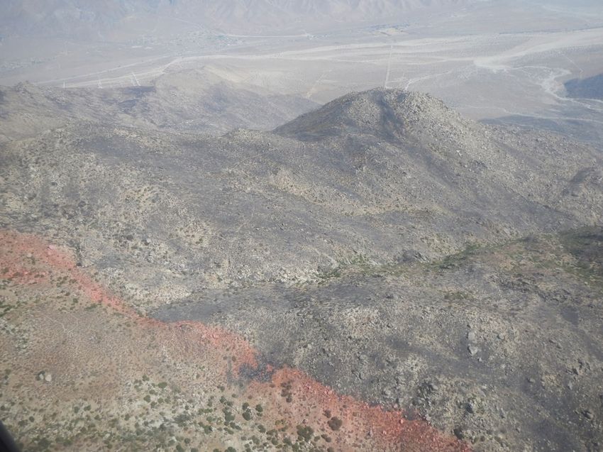
Picture of the Snow Creek Watershed
1|PageUSDA FOREST SERVICE FS-2500-8 (2/20)
Date of Report: October 6, 2020
BURNED-AREA REPORT
PART I - TYPE OF REQUEST
A. Type of Report
☒ 1. Funding request for estimated emergency stabilization funds
☐ 2. No Treatment Recommendation
B. Type of Action
☒ 1. Initial Request (Best estimate of funds needed to complete eligible stabilization measures)
☐ 2. Interim Request #___
☐ Updating the initial funding request based on more accurate site data or design analysis
PART II - BURNED-AREA DESCRIPTION
A. Fire Name: Snow B. Fire Number: CA-RRU-119353
C. State: California D. County: Riverside
E. Region: 05 Pacific Southwest F. Forest: San Bernardino
G. District: San Jacinto H. Fire Incident Job Code: 1502 PNNLV1
I. Date Fire Started: 9/17/2020 J. Date Fire Contained: 10/15/2020 (Estimated)
K. Suppression Cost: $1,750,000 (as of 9/30/2020)
L. Fire Suppression Damages Repaired with Suppression Funds (estimates):
1. Fireline repaired (miles): 0 (As of 9/30/20 no suppression repair had occurred)
2. Other (identify):
M. Watershed Numbers:
Table 1: Acres Burned by Watershed
HUC # Watershed Name Total Acres Acres Burned % of Watershed
Burned
181002010104 Upper San Gorgonio
22,894 14 0.06%
River
181002010105 Middle San Gorgonio
17,978 91 0.5%
River
181002010106 Snow Creek 10,991 3,629 33.0%
181002010107 Lower San Gorgonio
14,529 2,387 16.4%
River
181002010304 Chino Canyon-
31181 363 1.16%
Whitewater River
2|PageUSDA FOREST SERVICE FS-2500-8 (2/20)
N. Total Acres Burned:
Table 2: Total Acres Burned by Ownership
OWNERSHIP ACRES
NFS 4,466
BLM 890
STATE 0
PRIVATE 1,128
TOTAL 6,484
O. Vegetation Types:
Desert mixed shrub, semi-desert chaparral, montane mixed chaparral, Encelia-sage scrub, canyon live oak
woodlands, and riparian vegetation types burned in the Snow Fire.
P. Dominant Soils:
91 percent of the fire is mapped simply as Rock Outcrop, and the remaining soils are riverwash, or Soboba
family, which formed on alluvial fans. The two Rock Outcrop map units should be mapped as rubble land, or a
similar map unit that would better describe the fractured and discontinuous grantic bedrock outcrops with
sandy-loam or sand soils forming between the unweathered blocks. Surface rock approaches 50% on some
slopes, but more area has enough soil to support sparse desert vegetation.
Q. Geologic Types:
The San Bernardino National Forest (SBNF) includes parts of, two major geologic-geomorphic provinces of
western North America - the Transverse Ranges and the Peninsular Ranges provinces. The San Gabriel and
San Bernardino Mountains are part of the eastern Transverse Ranges and the San Jacinto and Santa Rosa
Mountains, Thomas Mountain, and Coahuila Mountain are part of the northern Peninsular Ranges. The
geology of the two provinces is vastly different one from the other (Matti & Morton, 2000).
The Transverse Ranges province boundary south of the San Gabriel Mountains is the Cucamonga fault zone,
a major compressional fault zone at the base of the mountains. East of the San Gabriel Mountains the province
boundary is right-laterally offset 15-20 km by the San Jacinto fault and is located in the structurally complex
San Gorgonio Pass area (Matti & Morton, 2000).
The San Bernardino National Forest south of San Gorgonio Pass encompasses several mountain
masses that we refer to collectively as the San Jacinto Mountains block. Included within this block are the San
Jacinto Mountains themselves, with their topographic culmination of San Jacinto Peak (10,804 ft); the Santa
Rosa Mountains; and the Cahuilla Mountain area. The San Jacinto Mountains form a high standing massif
tiered by several erosional levels that form a succession of relatively flat benches or plateaus that step up
toward the summit apex. On the north and northeast, this massif drops precipitously into San Gorgonio Pass
and into the Coachella Valley; to the south and southeast, the massif descends to the lowest erosional surface
in the block, represented by Garner Valley and Pinon Flat (Matti & Morton, 2000).
The Snow Fire occurred on the northeastern end of the San Jacinto Mountains block. Physiography of the
burned area is dominated generally by extremely steep and rugged terrain, dissected ridge lines and drainages
to a young alluvial fan.
Major drainages in the burned area include large portions of the Snow Creek and Lower San Gorgonio River,
with smaller portions of the Upper San Gorgonio River, Middle San Gorgonio River and Chino Canyon-
Whitewater River. Elevations in the burn area range from about 1,200 feet above sea level at the north end of
the fire to 6,100 feet above sea level at the south end of the fire
The San Jacinto Mountains are tectonically active and uplifting mountains displaced by young faults of the San
Jacinto fault zone. The forces lifting the mountains are being countered by opposing forces tearing them
3|PageUSDA FOREST SERVICE FS-2500-8 (2/20)
down. Forces such as gravity, moving water, wind, earthquakes and human activities interact and combine to
bring down small particles to whole hillsides at a time. The fluvial geomorphic processes which have shaped
and are currently shaping these ever-changing mountains include land-sliding of various types, rock-fall, dry
ravel, sheet and rill erosion by water and wind, flooding and debris flows.
San Jacinto Mountains block geologically is not very diverse. Bedrock within the Snow Fire burned area
mainly consists of crystalline basement terranes composed of plutonic igneous rocks.
R. Miles of Stream Channels by Order or Class:
Table 3: Miles of Stream Channels by Order or Class
STREAM TYPE MILES OF STREAM
PERRENIAL 0
INTERMITTENT 29.73
EPHEMERAL 224.69
OTHER 0
(DEFINE)
S. Transportation System:
Trails: National Forest (miles): 8.71 Other (miles): 0
Roads: National Forest (miles): 0 Other (miles): 0
PART III - WATERSHED CONDITION
Within the Snow Fire burned area, evidence of mass wasting as debris slides, debris flows, and rock fall are
widespread. In addition, numerous slopes and drainages in the burn area have large amounts of stored
material, significant drainage areas, defined channels and steep gradients.
It is estimated that high intensity storms (>20 mm/hr.) tend to initiate/trigger debris flows, including summer
thunder-storms, as well as rain-on-snow events. The probabilities of debris flows are very high in this
landscape under normal conditions, especially in the Snow Creek and Lower San Gorgonio River. In addition,
based on air reconnaissance, landslides and rock-fall are very likely along numerous steep burned slopes
within the burn area of the Snow Fire.
Now, as a result of the removal of vegetation by the fire, soils are exposed and have become weakened,
hydrophobicity conditions have changed and rocks on slopes have lost their supporting vegetation. Due to
these new post-fire conditions, roads, trails and water systems are at risk from numerous geological hazards
as rolling rocks, debris flows, debris slides and hyper-concentrated floods. Risks to human life/safety,
infrastructure, facilities, roads, trails, water systems and natural resources is elevated in most areas in and
downstream of the Snow Fire.
A. Burn Severity (acres): All references to soil burn severity observations, effects, and ground
conditions associated with the Snow Fire are based on the modified BARC and not on a final
ground truthed soil burn severity model.
Table 4: Modified-BARC in lieu of Soil Burn Severity, Acres by Ownership
BARC class NFS BLM State Private Total % within the
(modified) Fire Perimeter
Unburned 665 134 0 178 976 15%
Low 3,078 740 0 878 4,696 72%
Moderate 713 16 0 73 801 12%
High 10 178 0 0 10 1%
Total 4,466 1,068 0 1,129 6,484 100%
4|PageUSDA FOREST SERVICE FS-2500-8 (2/20)
B. Water-Repellent Soil (610 acres, 9% of Fire):
Field surveys for ground-validating BARC mapping were not done in the Snow fire, for lacking timely access in
the Wilderness and high national preparedness level. The BARC mapping was adjusted using photography
from aerial reconnaissance, but without ground-validation it is not considered a soil burn severity map. Based
on fires with similar burn severity and vegetation patterns, fire-induced water repellency is expected to be
limited in extent within the Snow fire. Moderate burn severity occurred under shrubs and oak of sufficient
density to create water-repellent conditions in 50% of the area. Only 5-10% of Low burn severity is expected to
be water repellent.
C. Soil Erosion Hazard Rating:
Slight: 724 acres (11%), Moderate: 4964 acres (77%), Severe: 796 acres (12%)
Due to the low vegetation cover pre-fire, erosion hazards are naturally elevated in the Snow fire area. Post-
fire, erosion hazard is elevated in all the moderate burn severity, or ~800 acres.
D. Erosion Potential:
1-2 tons/acre (2 year runoff event)*
3-4 tons/acre (5 year runoff event)*
*Erosion modeling was not performed for the Snow fire; instead erosion potential is estimated based on natural
erosion rate properties (K and T factors). Most of the fire was low burn severity, appeared to have little
belowground heating, and is not expected to be hydrophobic in much area. Thus, erosion potential is also
expected to be low.
E. Sediment Potential:
Rowe, Countryman, and Storey (1949) developed estimates of annual erosion rates for watersheds in the burn
area based on measurements of sedimentation in reservoirs. On average, across the burn area, annual
sediment delivery is estimated to increase 1.4 times normal with an average of 1,372 cubic yards per square
mile. These estimates are in line with field observations of expansive low soil burn severity, sparse vegetation
(pre-fire), and rocky slopes. For much of the burn area the existing unstable slopes have not been made
significantly worse by fire effects, although they are inherently at risk of debris flow, rockfall, and flash flooding.
F. Debris Flow Potential:
The US Geological Survey (USGS) - Landslide Hazards Program, has developed empirical models for
forecasting the probability and the likely volume of post-fire debris flow events. To run their models, the USGS
uses geospatial data related to basin morphometry, burn severity, soil properties, and rainfall characteristics to
estimate the probability and volume of debris flows that may occur in response to a design storm (Staley,
2016). Estimates of probability, volume, and combined hazard are based upon a design storm with a peak 15-
minute rainfall intensity of 12 – 40 millimeters per hour (mm/h) rate. We selected a design storm of a peak 15-
minute rainfall intensity of 24 millimeters per hour (mm/h) rate to evaluate debris flow potential and volumes
since based for three reasons:
1. Post-fire debris flows are most often triggered by high-intensity, short-duration bursts of rain.
2. A 24 mm/h rain burst is likely to happen in most areas of the western U.S. (i.e. a 1-5-year recurrence
interval).
3. A 24 mm/h rain burst is known to trigger debris flows at USGS monitoring sites in burn areas.
Based on USGS debris flow modeling it appears that under conditions of a peak 15-minute rainfall intensity
storm of 24 millimeters per hour (0.95 inch/hr.), the probability of debris flows occurring is very low (0-10%) in
a majority of the channels/creeks in the Snow fire burn area. However, aerial reconnaissance observed active
debris flow channels were present in this area prior to the Snow Fire event This very low probability of the
USGS model illustrated that there is not a large difference between pre- and post-fire debris flow conditions.
Under these same conditions, predicted volumes in these channels are expected to range from 1K-10K cubic
meters in some channels to 10K-100K cubic meters in other channels. Based on the very low probabilities of
5|PageUSDA FOREST SERVICE FS-2500-8 (2/20)
debris flow initiation and low predicted volumes of debris flows, in the burn area appear to present a low
combine hazard. However, debris flows are common occurrences in this mountainous desert area regardless
of fire.
G. Estimated Vegetative Recovery Period (5-75 years):
The majority of desert mixed shrub, Encelia-sage scrub, semi-desert chaparral, lower montane chaparral, and
riparian vegetation communities burned at low to moderate intensity (Table 5). Riparian areas and willow shrub
vegetation had very low to moderate burn severity may recover within 3-5 years, whereas semi-desert
chaparral and desert mixed shrub recovery may be estimated between 10-40 years for areas that experienced
low to moderate burn severity. Recovery in semi-desert and desert mixed shrub communities may be more
complex compared to other vegetation communities; desert shrubs are more sensitive to fire, and it may take
longer to achieve greater native cover (approximately 30-75 years) depending on the pre-fire condition of the
vegetation community, environmental conditions (e.g. climate, topography, aspect, slope, etc), fire frequency,
and presence of non-native weeds (Abella 2010). Some previously disturbed communities that burned low to
moderate may be more vulnerable to re-invasion by fountaingrass seed that escaped direct fire exposure
(Adkins et al. 2011). Given enough space, resources, and time, fountaingrass, Sahara mustard, and other
noxious weeds can quickly invade and further degrade open, recently burned critical habitat in Snow Creek.
Both species are known to increase fuel loads and eventually alter natural fire regimes (Trader et al. 2006,
Poulin et al. 2007, Moloney et al. 2019). Frequent fire may negatively impact natural resource values (e.g.
native vegetation recovery in critical habitat and wilderness) recreation values (PCT), and life and property
values (neighboring mountain and desert communities).
Table 5. Vegetation burn severities (acres) estimated using the Snow Fire modified BARC map.
Very Low / Grand
Vegetation Community High Moderate Low
Unburned Total
Agriculture (General) - - - 0.07 0.07
Barren - 0.92 17.39 7.25 25.56
Canyon Live Oak - 14.08 37.91 17.90 69.90
Cheesebush - - - 2.20 2.20
Desert Mixed Shrub 2.37 364.17 2167.01 368.62 2902.17
Encelia Scrub 55.51 1368.03 154.91 1578.45
Lower Montane Mixed
3.65 109.79 91.02 62.08 266.56
Chaparral
Red Shanks Chaparral 2.58 2.27 4.85
Riparian Mixed Hardwood 2.07 6.37 4.22 12.65
Semi-Desert Chaparral 4.25 244.22 996.08 355.21 1599.76
Willow (Shrub) 7.97 6.89 0.30 15.16
Total 10.28 801.31 4692.97 972.76 6477.32
H. Estimated Hydrologic Response (brief description):
Elevation across the Snow Fire burn area ranges from about 1,240 to 6,080 feet. Average annual precipitation
for select pour points is about 17 to 25 inches annually and mostly arrives between November and April
although summer thundershowers are common in August and early fall. The area previously burned in the
Silver Fire 2013, Blaisden Fire 2005, and Verbina Fire 2004.
Damaging Storms: Although not the only types of storms that could occur, two common storm types that could
cause significant damage within the burn area are monsoonal thunderstorms and storms related to
atmospheric rivers. Short duration, high intensity storms (such as a monsoonal thundershowers) frequently
trigger debris flows. The second storm type is a long duration storm, commonly linked to atmospheric rivers.
6|PageUSDA FOREST SERVICE FS-2500-8 (2/20)
Major flooding events have occurred across Southern California due to atmospheric rivers which contain large
amounts of water vapor. One such weather system is known as the “Pineapple Express," which moves
subtropical moisture from the latitudes of the Hawaiian Islands to Southern California.
Hydrologic Processes: Functioning of hydrologic processes is connected to vegetation (type, density, litter and
organic matter accumulation) and soil types. Fire causes impacts to several hydrologic processes including
reduction in interception, transpiration, and infiltration, and increases in soil moisture and the rate of runoff (due
to lack of litter and decreased surface roughness). Removal of vegetation and changes to soil such as
increases in hydrophobicity, changes in soil structure, and removal of duff and organic matter alters these
processes and ultimately lead to increases in runoff, peak flows and erosion. These alterations are typical of
soils classified as having incurred moderate to high soil burn severity.
The Snow Fire had minimal percentage of moderate and high soil burn severity. The terrain is extremely rocky
and steep, with cliffs at the headwaters and rocky slopes below. Although rocky slopes have the potential to
increase the rate of runoff, rocky slopes can also protect soils from erosion and provide surface roughness.
The majority of the Snow Fire burned at low soil burn severity with a small percentage of moderate soil burn
severity. There did not appear to be a thick accumulation of duff available to burn in the Snow Fire. Bulked
discharge within the burn area is expected to be approximately 106-128% of normal, which is a considered to
be a minor to moderate increase.
Channel crossings, floodplains, washes, and depositional fans have an inherent risk of flooding which will be
exacerbated by the fire. Increased runoff and sediment delivery (ex. surface erosion, sediment-laden flows)
may cause channel migration, flooding in low-lying areas, and filling-in of pools.
Watershed response in the burn area will result in minimal to moderate increases in peak flows and deliver
slightly increased sediment loads. Woody debris could be increased although there are limited trees in the burn
area. Increased flows could negatively impact infrastructure in low-lying areas and pose a threat to life and
safety. It is important to note that downstream areas that experience regular flooding or difficulty controlling
drainage during small storms will be very likely to experience flooding and/or failure in post-fire storms. Bulking
and increased flows may cause channels to flood, divert, or migrate to areas that do not usually flood.
Water Quality: Wildfires primarily affect water quality through increased sedimentation. As a result, the primary
water quality constituents or characteristics affected by this fire include color, sediment, suspended material,
and turbidity. The loss of riparian shading and the sedimentation of channels may increase stream
temperature. Vegetation mortality can result in increases in floatable material such as large woody debris.
Post-fire delivery of organic debris to stream channels can potentially decrease dissolved oxygen
concentrations in streams and pools. Fire-derived ash inputs can increase pH, alkalinity, conductivity, and
nutrient flux (e.g. ammonium, nitrate, phosphate, and potassium), although these changes are generally short
lived. Given the low soil burn severity in the Snow Fire, it is estimated there will be minimal ash available to
significantly impact water quality.
PART V - SUMMARY OF ANALYSIS
Introduction/Background
The Snow Fire is located on the San Bernardino National Forest on the San Jacinto Ranger District. The Fire
started on Thursday September 17th, 2020. The cause of the fire is unknown/under investigation and started
near the Snow Creek Village area. As of Septenber 30th, the Snow Fire was being reported as 95% contained
and stable at 6,254 acres.
The soil burn severity (SBS, per modified BARC) shows 13% burned at high and moderate soil burn severity.
The rest of the fire was ether low soil burn severity or unburned. All referneces to soil burn severity
observations, effects, and ground conditions associated with the Snow Fire are based on the modified BARC
and not on a final ground truthed soil burn severity model.
7|PageUSDA FOREST SERVICE FS-2500-8 (2/20)
Based on historic precipitation patterns, it can be expected that fall storms have a high probablity in occuring
within the weeks following the Snow Fire. The risk of flooding and erosion events will increase as a result of
the fire, creating hazardous conditions within and downstream of the burn area.
The fire was divided into sub-watersheds with “pourpoints” established at the bottom of the burned watersheds
or where critical values are located. Watershed runoff response is referenced to these points.
A. Describe Critical Values/Resources and Threats (narrative):
A BAER team began assessing the area for post-fire emergencies on September 21, 2020. In that time the
team has identified the following critical values and post-fire threats. The full list of critical values analyzed and
risk determinations is included in Appendix 3. The Critical Values described below are included within the
report as these values were brought forward with proposed treatments later in the report.
Interim reports may be submitted as additional assessments are completed.
The risk matrix below (Table 6), Exhibit 2 of Directive No.: 2500-2020-1 was used to evaluate the Risk Level
for each value identified during Assessment.
Table 6: Critical Value Matrix
Probability of Magnitude of Consequences
Damage or Loss Major Moderate Minor
RISK
Very Likely Very High Very High Low
Likely Very High High Low
Possible High Intermediate Low
Unlikely Intermediate Low Very Low
1. Human Life and Safety (HLS):
Based on the potential for flooding, sediment laden flows, rock falls, etc., the BAER team identified an
intermediate to high risk for human life and safety of the public and USFS employees within the burn
area. The burn area in general will experience flows 106-128% of normal. There is a possibility of debris
flows and flooding with moderate to major consequences to human life and safety.
2. Property (P):
Trails (Pacific Crest Trail):
There is one trail located within and affected by the Snow Fire. This is a section of the Pacific Crest
Trail (8.7 miles) of the PCT are within the burned area and portions of the trail will possibly be damaged
by increased overland and debris flows where modified BARC indicates soil burn severity was
moderate. Watershed effects are considered possible and the magnitude of consequence is moderate
due to the threat of rockfall/debris flow causing serious injury/loss of life on this popular trail. Overall risk
is intermediate and mitigation treatments are proposed.
3. Natural Resources (NR):
Hydrologic Function:
Fire impacts proper functioning of hydrologic processes with the greatest and longest lasting impacts
occurring from high soil burn severity and anthropogenic activities. Fire impacts within moderate, low,
and very low burn areas are recoverable and expected to diminish as vegetation reestablishes. Most of
the burn area resulted in low soil burn severity. The greatest threats to recovery are threats from mass
wasting. The impacts to Hydrologic Function are expected to be possible and magnitude of
consequences are minor, resulting in a low risk level.
Soil Productivity:
8|PageUSDA FOREST SERVICE FS-2500-8 (2/20)
It is possible that soil productivity will be impacted in very large storms (10-year or greater runoff
event) due to elevated surface erosion in moderate burn severity. The magnitude of consequence of
this soil loss is minor because the area of moderate burn severity is a small part of the fire, and erosion
rates in low severity are not expected to be much above normal. Thus, the overall risk to soil
productivity is low.
Wildlife: Threatened and Endangered Species, and Wildlife Water Sources
There are four endangered species within the fire perimeter or just downstream of the burned area.
These are Peninsular Bighorn Sheep, Least Bell’s Vireo, Desert Tortoise, and Coachella Valley Fringe-
toed Lizard. Threats to endangered species include hillslope erosion/debris flow, non-native invasive
plants, Off Highway Vehicle (OHV) trespass, and impacts on water sources.
Threatened and Endangered Species: Within the Snow Fire perimeter, the terrain is extremely rocky
and the burn severity was mostly low to moderate. The increase in stream flows is expected to be
minimal and the increase in erosion is expected to be moderate; therefore no treatment is proposed for
risks related to erosion and debris flows. With implementation of a BAER treatment to survey and treat
non-native plants within the fire area the risk of adverse impacts from non-native invasive plants is
reduced (see botany section). OHV trespass may increase within the fire area, particularly in areas
adjacent to private lands where control lines were established. This is primarily an issue on Bureau of
Land Management lands and effects are expected to be minor; no treatment is proposed. The BAER
team has provided a recommendation to monitor and mitigate such incursions if they occur.
Wildlife water sources: Water sources such as streams and springs are expected to be minimally
affected as the Snow Fire area is very rocky and the burn severity was mostly low to moderate. No
treatment is proposed to protect water sources as the risk to these resources is low.
Botany:
Natural Resources- T&E habitat- Federally Listed Endangered Species, Coachella Valley milkvetch
It is very likely that burned critical habitat will be threatened by the spread of noxious weeds that
burned in the fire and are expected to resprout, recolonize, and expand in the burned area. Noxious
weeds adjacent and/or in close proximity to the burned area will likely invade the burned area, causing
degradation and eventual loss of critical habitat for Coachella Valley milkvetch. There are major
consequences to impacted critical habitat, such as loss of suitable habitat and local extirpation. There is
a very high risk of degradation or loss of Coachella Valley milkvetch critical habitat, therefore this is a
BAER emergency, and Early Detection Rapid Response (EDRR) noxious weed treatments are
recommended.
Native Vegetation Recovery: Burned Areas
It is very likely that noxious weeds present adjacent or in close proximity to the burned area will impact
native vegetation recovery and invade the burned area. Forest visitors (e.g. PCT hikers) may
unintentionally spread existing weed species and/or introduce new weeds by carrying in and dispersing
seeds on boots into the burned areas. There are major consequences from lack of native vegetation
recovery in recently burned desert shrub communities. Ecosystem structure and function may be
compromised by noxious weed invasion due to loss of native plant biodiversity and presence. Type
conversion from desert mixed shrublands to non-native grasslands or forblands can alter the natural fire
regime and fire frequency in non-adapted fire ecosystems. The risk for irreversible habitat type
conversion from desert shrublands to non-native grasslands is very high. Therefore, this is a BAER
emergency, and EDRR noxious weed treatments are requested to mitigate invasive weed introductions,
spread, and proliferation from fire suppression activities into burned critical habitat and San Jacinto
Wilderness.
Native Vegetation Recovery: Suppression Areas
9|PageUSDA FOREST SERVICE FS-2500-8 (2/20)
No noxious weed mitigations were in place during fire suppression activities. Introduction and dispersal
of non-native weeds from boots and fire equipment movement on constructed suppression lines
threaten the recovery of native vegetation in fire suppression areas. It is very likely that noxious weeds
present adjacent or in close proximity to fire suppression areas will recolonize the site and expand.
There are major consequences to the introduction and spread of weeds along the PCT and throughout
the San Jacinto Wilderness. Ecosystem structure and function may be compromised by noxious weed
invasion due to loss of native plant biodiversity and presence. Type conversion from desert mixed
shrublands to non-native grasslands or forblands can alter the natural fire regime and fire frequency in
non-adapted fire ecosystems. Therefore, the risk for permanent alteration of native desert shrub
communities is very high if recommended EDRR surveys and treatments are not implemented.
Therefore, this is a BAER emergency, and Early Detection Rapid Response noxious weed treatments
are strongly recommended.
4. Cultural and Heritage Resources:
Six cultural resources have been identified within the Snow Fire burn perimeter and adjacent areas
downstream on Forest Service Lands. Four of the resources are pre-contact archaeological sites
including rock shelter and a portion of an ethnographically known village site. The historic period sites
are the Pacific Crest Trail and the Snow Creek Recreation Residence tract. Low to moderate intensity
fire burned over all of the sites except for the recreation residence tract. Due to the low intensity of the
fire and rocky terrain, first order fire effects are unlikely to the archaeological sites. Portions of the
Pacific Crest Trail may experience trail bed loss in spots.
It is possible debris flows and flooding will impact the Snow Creek Recreation Residence Tract. The
magnitude of consequence is major because the USGS modeling indicates moderate debris flow
potential, possibly resulting in permanent loss of the last historic cabin in the tract. This will adversely
affect the tract’s eligibility for the National Register of Historic Places. Therefore, a high risk to the tract
exists.
5. Private Property and other jurisdictions:
Federal and private landownership are checkerboarded throughout the fire area. The fire burned
adjacent to the community of Snow Creek. Both Snow Creek and the Falls Creek Forest Service
Recreation Residence Tract are downstream of the fire area. The BAER Team shared information on
watershed response and potential threats to non-Forest assets with affected entities and responsible
agencies such as Bureau of Land Management, Riverside County, Natural Resources Conservation
Service, National Weather Service and U S Army Corp. of Engineers. Non-Forest assets are addressed
by the respective responsible agencies.
B. Emergency Treatment Objectives:
The objectives of the Snow Fire BAER treatments are to:
• Protect life and safety on NFS Trails and at a recreation residence
• Prevention/mitigation for conversion, degradation, or loss of critical habitat for federally listed endangered
species, Astragalus lentiginosus var. coachellae, Coachella Valley milkvetch.
• Support native vegetation recovery in burned areas- critical habitat and San Jacinto Wilderness.
• Support native vegetation recovery in fire suppression areas- San Jacinto Wilderness
• Protect heritage resources from loss.
• Coordinate post-fire response with other agencies and interested parties.
•
C. Probability of Completing Treatment Prior to Damaging Storm or Event:
Land: 80%
Channel: N/A
10 | P a g eUSDA FOREST SERVICE FS-2500-8 (2/20)
Roads/Trails: 60%
Protection/Safety: 80%
D. Probability of Treatment Success
Table 7: Probability of Treatment Success
1 year after 3 years after 5 years after
treatment treatment treatment
Land 80 90 100
Channel N/A N/A N/A
Roads/Trails 70 80 80
Protection/Safety 90 90 100
E. Cost of No-Action (Including Loss): Potential lost market value plus assessment costs. This does not
include a monetary value on loss or harm to human life.
F. Cost of Selected Alternative (Including Loss): Potential lost market value plus assessment costs plus
treatment costs.This does not include a monetary value on loss or harm to human life.
G. Skills Represented on Burned-Area Survey Team:
☒ Soils ☒ Hydrology ☒ Engineering ☒ GIS ☒ Archaeology
☒ Weeds ☒ Recreation ☐ Fisheries ☒ Wildlife ☒ Geology
☒ Other: Interagency Coordination
Team Leader: Christopher Stewart
Email: christopher.s.stewart@usda.gov Phone(s): 360-854-2634; 360-764-4251
Forest BAER Coordinator: Kim Boss/Drew Farr
Email: kim.boss@usda.gov/drew.farr@usda.gov Phone(s): 909-382-2936/909-382-2816
Team Members:Table 8: BAER Team Members by Skill
Skill Team Member Name
Team Lead(s) Chris Stewart, Carly Gibson
Soils Curtis Kvamme
Hydrology Emily Fudge
Engineering Joshua Direen
GIS Celia Yamagiwa
Archaeology Jay Marshall, Eraina Nossa
Weeds Lauren Quon, Emma Williams
Wildlife Kirsten Winter, Rari Marks
Recreation Daniel Kasang
Geology Barton Wills
Other Todd Ellsworth, Katie VinZant
H. Treatment Narrative:
Land Treatments:
11 | P a g eUSDA FOREST SERVICE FS-2500-8 (2/20)
Early Detection, Rapid Response—Related to Burned Area:
Weed detection surveys and rapid response eradication treatments are requested for the features within the
burned areas, which include the Pacific Crest Trail (PCT) (8.71 miles) and intermittent streams (7.45 miles).
Surveys and treatments implemented post-fire will prevent weed introductions and spread in burned critical
habitat and San Jacinto Wilderness. Fountaingrass, Sahara mustard, and other noxious weeds that existed
pre-fire condition along these weed corridors will be surveyed and treated as a part of rapid response
implementation related to burned areas. Work may be implemented by a 6-person contract weed crew, with
oversight by 2 Forest Botanists to lead implementation, monitor for treatment efficacy, and complete
administrative coordination. Supplies (tools) and fuel mileage are also included in the estimated treatment
costs.
Early Detection, Rapid Response—Related to Suppression Area:
Early Detection and Rapid Response treatments are requested on suppression related disturbance features
including constructed hand line (5.73 miles) and helispots (2). Constructed hand line will be the first priority for
EDRR surveys and treatments, whereas helispots shall be second priority for survey and treatment.
Suppression features including handlines and helispots serve as the main weed corridors on this incident and
require careful survey and treatment to prevent Sahara mustard introduction and spread. Work may be
implemented by a 6-person contract weed crew, with oversight by 2 Forest Botanists to lead implementation,
monitor treatment efficacy, and complete administrative coordination. Supplies (tools) and fuel mileage are
also included in the estimated treatment costs
Heritage Site Treatments:
A single historic property, The Snow Creek Recreation Tract, was identified to be at risk from predicted storm
induced watershed response. USGS modeling indicates a moderate debris flow in the channel just above
recreation tract in addition to a possible increase in flooding. BAER team specialists determined that proposed
treatments, e.g., K-rails, may become part of the debris flow and exacerbate the effects to historic properties, a
heritage treatment to protect this site from debris flows and watershed response has not been proposed. To
mitigate the loss of an historic property, a heritage treatment of enhancing existing documentation of the
recreation residence tract through digital or other means to preserve its heritage values has been proposed.
Channel Treatments: No proposed channel treatments.
Roads and Trail Treatments:
Trail Stabilization:
Clean existing rolling dips, install new dips in anticipation of post-fire increased runoff; remove trail berms to
increase outboard drainage where possible, and possibly armor key ephemeral drainages to prevent
undercutting and loss of trail tread. All trail runoff work would be focused on midslope trails in areas of
moderate soil burn severity. Storm inspection and response will be done following storm events to identify
post-fire damages that may occur. Existing agreements with UCC or CCC will be utilized for trail crew.
Protection/Safety Treatments:
PCT Warning Signs and Closure:
The recommendation is to close the PCT within the burned area to protect public safety through the
winter/spring 2020/2021. Closure and warning signs are needed at access points and trailheads. The burned
portions of the trail will be re-evaluated in spring 2021 to determine if lifting of the closure is appropriate. This
work will be accomplished by Force Account staff.
Interagency/Partner/Permittee Coordination:
The Forest Service plans on continuing to collaborate and communicate with partnering agencies, other
entities and organizations and the public. Many non-Forest Service entities, partners and permittees(recreation
12 | P a g eUSDA FOREST SERVICE FS-2500-8 (2/20)
residence, Desert Water Authority, NOAA, NRCS, private landowner) that have infrastructure in the fire area
are actively repairing damaged infrastructure and/or implementing mitigations to reduce post-fire damage. The
BAER team’s findings will be shared with those entities and other responsible agencies so that they can plan
measures to protect/prepare infrastructure from post-fire watershed response events. There is also a need to
close a recreation residence at risk from flooding and debris flows. The cost reflects time the Forest spends
with coordination and facilitation of emergency treatments from partners and permittees. Above and beyond
facilitating protection measures for non-Forest Service entities threats to life, property and water quality
requires continued coordination with many agencies.
I. Monitoring Narrative: No monitoring is proposed.
13 | P a g eYou can also read