Models of tsunami waves at the Institute of Ocean Sciences - Josef Cherniawsky and Isaac Fine
←
→
Page content transcription
If your browser does not render page correctly, please read the page content below
Models of tsunami waves at the Institute of Ocean Sciences
                 Josef Cherniawsky and Isaac Fine

     Ocean Science Division, Fisheries & Oceans Canada, Sidney, BC

                                                          Port Alberni, March 27, 2014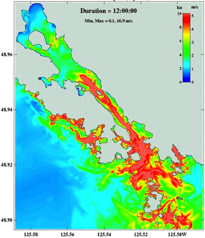
Acknowledgements:
  Richard Thomson
Alexander Rabinovich
     Kelin Wang
    Kim Conway
     Vasily Titov
    Jing Yang Li
   Brian Bornhold
  Maxim Krassovski
  Fred Stephenson
    Bill Crawford
      Pete Wills
    Denny Sinnott
    … and others!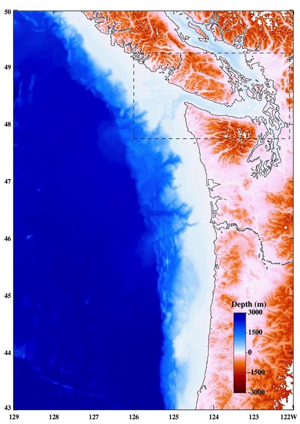
Our tsunami web site:

http://www.pac.dfo-mpo.gc.ca/science/oceans/tsunamis/index-eng.htm

           … or just search for “DFO tsunami research”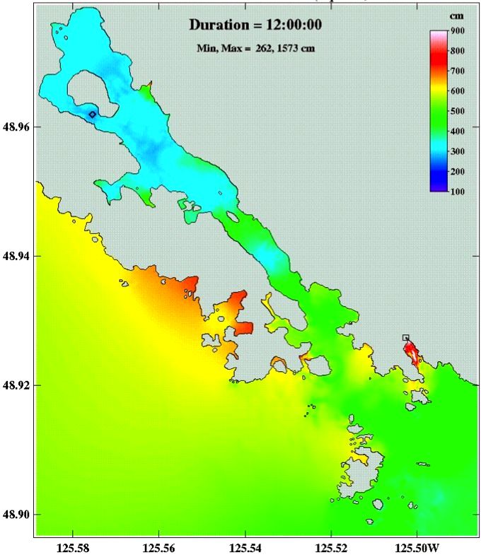
An outline …

oIntroduction

oModels   of submarine landslide tsunamis (4 min)
oA model   of a Cascadia earthquake tsunami (4 min)
oTsunami   wave amplification in Alberni Inlet (4 min)
oA model   of the 2012 Haida Gwaii tsunami (4 min)
oQuestions
Examples of models of landslide generated tsunamis in Canada
                                        - some references -
Fine, I.V., Rabinovich, A.B., Thomson, R.E. and E.A. Kulikov. 2003. Numerical Modeling of
Tsunami Generation by Submarine and Subaerial Landslides. In: Ahmet C. et al. [Eds.]. NATO
Science Series, Underwater Ground Failures On Tsunami Generation, Modeling, Risk and Mitigation.
Kluwer. 69-88.

Fine, I. V., A.B. Rabinovich, B. D. Bornhold, R.E. Thomson and E.A. Kulikov. 2005. The Grand
Banks landslide-generated tsunami of November 18, 1929: Preliminary analysis and numerical
modeling. Marine Geology. 215: 45-57.
Fine, I.V., Rabinovich, A.B., Thomson, R.E., and Kulikov, E.A., 2003. Numerical modeling of
tsunami generation by submarine and subaerial landslides, in: Submarine Landslides and
Tsunamis, edited by Yalciner, A.C., Pelinovsky, E.N., Synolakis, C.E., and Okal, E., NATO Adv.
Series, Kluwer Acad. Publ., Dorderecht, pp 69–88.

Rabinovich, A.B., Thomson, R.E., Bornhold, B.B., Fine, I.V. and E.A. Kulikov. 2003. Numerical
modelling of tsunamis generated by hypothetical landslides in the Strait of Georgia, British Columbia.
Pure appl. Geophys. 160: 1273-1313.
Thomson, R., Fine, I., Krassovski, M., Cherniawsky, J., Conway, K. and Wills, P., 2012. Numerical
simulation of tsunamis generated by submarine slope failures in Douglas Channel, British Columbia.
DFO Can. Sci. Advis. Sec. Res. Doc. 2012/115. v + 38p.
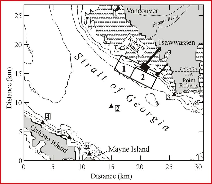
Landslide-generated tsunami: sediments in Strait of Georgia

                                                  Hypothetical
                                                  failure of the
                                                  Fraser River
                                                  delta front

                                                   Rabinovich et al. 2003
                                                   Fine et al. 2003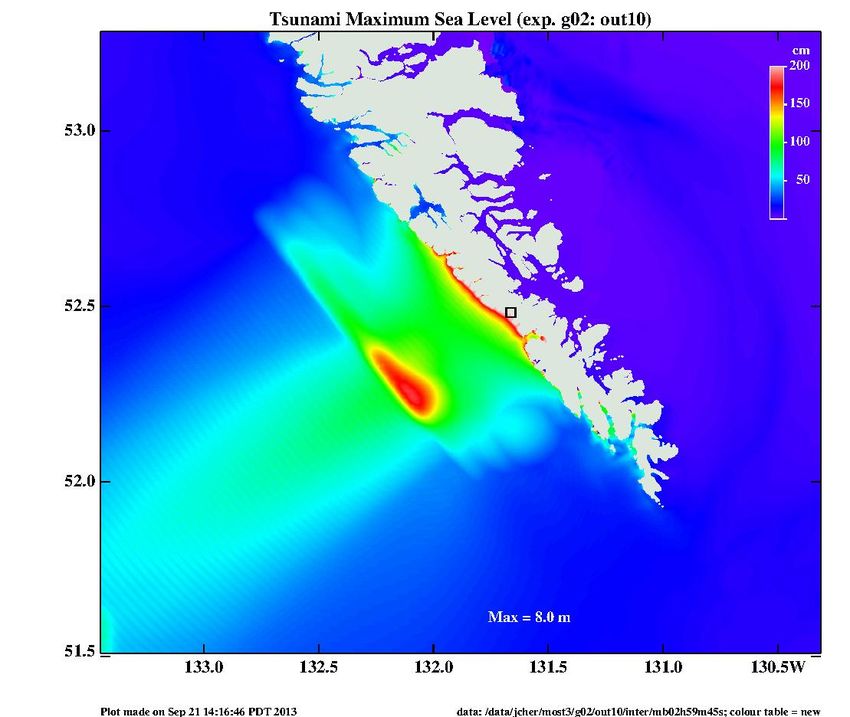
Submarine Slide   Tsunami

                            Time to cross
                            the strait ~7 min
Modeled
           wave heights
Richmond   for the case of a
           “Case 1” slide:

           area = 7.3 km2
           volume = 0.75 km3

           Waves up to 18 m
           high hit Galiano
           and Main Islands;
           less than 5 m on
           the mainland side.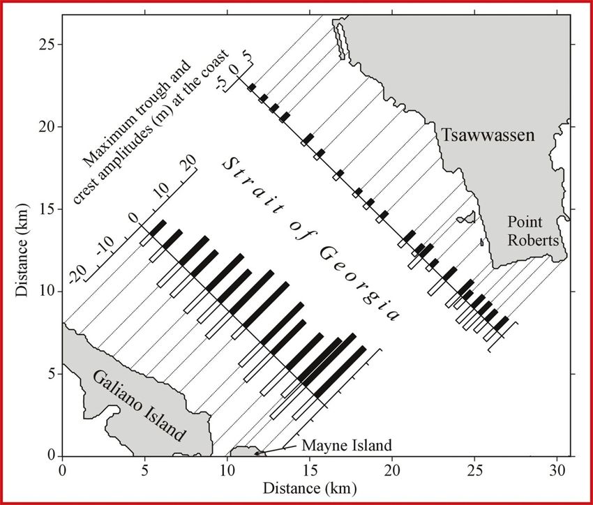
Historic landslides
IOS models of earthquake generated tsunamis
                                   (some references)
Cherniawsky, J.Y., Titov, V.V., Wang, K. and J.-Y. Li. 2007. Numerical simulations of
tsunami waves and currents for southern Vancouver Island from a Cascadia megathrust
earthquake. Pure and Applied Geophysics. 164:465-492.
Cherniawsky, J.Y., 2007. Preliminary results from a project “Tsunami Modelling with
Inundation: Sooke Harbour and Sooke Basin”. Unpublished Report for the Municipality of
Sooke (can be requested from the author).
Fine, I., J.Y. Cherniawsky, A.B. Rabinovich and F. Stephenson. 2009. Numerical
Modeling and Observations of Tsunami Waves in Alberni Inlet and Barkley Sound, British
Columbia. Pure and Applied Geophysics. 165:1019-2044.
Titov, V.V. and Synolakis, C.E. (1997), Extreme inundation flows during the Hokkaido–
Nansei–Oki tsunami, Geophys. Res. Lett. 24(11), 1315–1318. [nested-grid MOST model]
An example of nested model grids
grid size ~ 300 m
Alberni Inlet
grid size ~ 50 m
grid size ~ 900 mSome plausible sea-bottom uplift scenarios for a CSZ earthquake
A B
Scenario A (Satake et al., JGR 2003; Wang et al., JGR 2003). Scenario B (Wang and He, BSSA 2008).Initial bottom deformation and
wave propagation on a coarse
(900 m) grid
Scenario A
(Wang et al. 2003)
Cherniawsky et al. 2007Maximum heights: Comparison of the two earthquake scenarios Scenario A without run-up (from CTWL2007) Scenario B with run-up
Esquimalt and Victoria Harbours

                            4.2 m

Victoria Inner Harbour
                            Esquimalt
                                              Victoria

                            Maximum wave height
 Esquimalt Harbour           for 12 hour duration
Esquimalt Sea level time series at
various sites
Site 5
Time (min)
Victoria Site 1
Time (min)Maximum water speed Esquimalt Harbour Victoria Harbour
Sea level time series at         Outer Coast:
     various sites         Ucluelet Inlet and vicinity

                                                  Itatsoo Bay
Ucluelet Inlet Maximum water height Maximum water speed
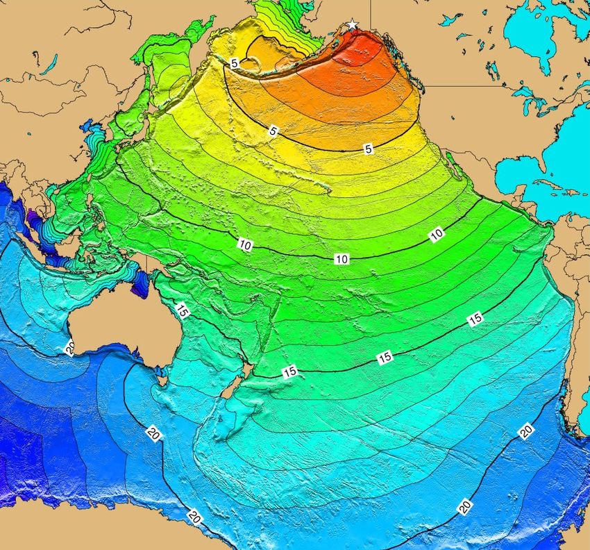
1964 Great Alaska Earthquake
             tsunami waves travel times

                                  Vancouver
                                      Island

(from NOAA web site)
Port Alberni tide gauge
PST
4m
1.7 hr
2.0 hr
Port Alberni tide gauge March 28-29, 1964Admittance functions for Bamfield and Port Alberni (relative to Tofino)
from power spectra of background sea-level oscillationsSpectral response method
Alberni
49.2N Numerical model details:
C5 Linear “flux” model
C4 (similar to a linear version of
TUNAMI by Imamura)
grid size: 40x40 m
49.0N
C3 (1213x1223 grids)
C2 time step: 0.43 sec
duration: 240 hours
C1 open boundary conditions:
radiation + prescribed waves
Bamfield (from AR spectral function)
48.8N
Results processed using
125.6W 125.4W 125.2W 125.0W 124.8W standard spectral analysisBamfield - Port Alberni response function
16
100 min 44 min
14
12
10
Amplitude
8
6
4
2
0
900
800 Data
700 Model
Phase (degree)
600
500
400
300
200
100
0
0 1 2 3
Frequency (cph)
(from cross-spectra between Alberni and Bamfield)The Haida Gwaii earth(sea)quake (from James et al. Eos 2013)
USGS finite fault model (G. Hayes 2012) n NEIC hypocenter (Lon.=-132.1 deg.; Lat.=52.7 deg.). n Mw= 7.46e+27 dyne.cm n Nodal plane (strike=323.0 deg., dip=25.0 deg.). n Nx (along-strike)=18; dx=14 km n Ny (downdip)=10; dy=9 km n Oblique trust faulting
Correcting the USGS source position using inverse travel times to the 4 nearest DARTs
Original Shifted
1000 m
Isochrones: black – for tsunami arrival times (first rise ± 1 min); red – for 1st tsunami maximum
Shadow zone: grey area
Source function (smoothed): thick yellow line – 10 cm contour; thick red – 100 cm contour
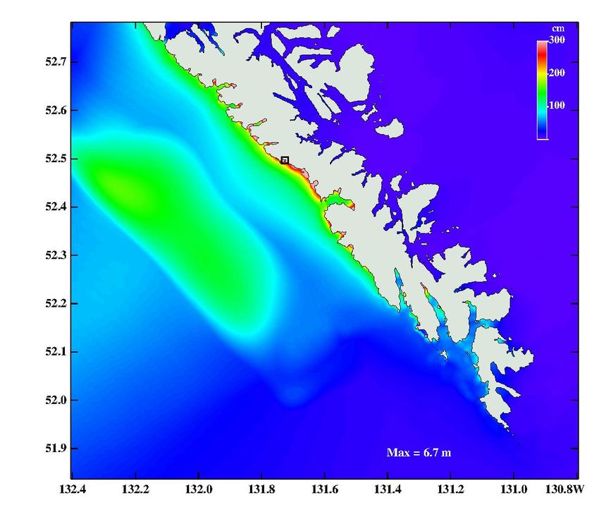
(Fine et al. 2013a,b)Nested grid tsunami model using the MOST3 code Initial surface deformation with its maximum on QCT (USGS/IOS source)
Tasu
                    Sound

                                          8.4 m
                                Gowgaia
                                Bay

Maximum sea level on a medium grid (~130 m grid size)
A revised uplift model based on GPS data (from Kelin Wang)
Two possible initial deformation scenarios

Hayes – Wang – Fine (HWF)                        Lay et al. – Wang – Fine (LWF)

(the last “seabed to sea surface” transformation was done as in Fine and Kulikov 2011)
from HWF source (coarse grid)
Maximum tsunami waves (HWF)
Seaquake/Davidson Inlet

Model bathymetry
Maximum tsunami wave and maximum speed (HWF)
You can also read