Montana Water Supply & Drought Outlook - Spring 2021
←
→
Page content transcription
If your browser does not render page correctly, please read the page content below
Montana Water Supply & Drought Outlook –
                        Spring 2021

Water Supply Overview:
Precipitation:
The 2020 Water Year closed with higher than average temperatures, and much below average
precipitation in August and September. This weather pattern carried into the first part of October with
high temperatures setting some daily records across the state followed by daily record setting lows in
the latter part of the month. Helena saw a new record high for October 6 of 84 degrees followed by a
new record low for October 26 of minus 6 degrees. October precipitation brought average to above
average precipitation across most of Montana, but again southwest and eastern Montana remained
abnormally dry as they had through much of the

summer and fall. A large, statewide snow event late in the month provided much needed moisture
following the dry late summer and early fall. The mid to late October storms and colder than average
temperatures jump started snow accumulation in the mountains. The early, heavy snowfall and cold
Page |1
temperatures seemed to indicate that projections for the La Niña weather pattern for the winter would
come to fruition. However, much above average temperatures and below average precipitation across
the state in November, December, January, and the first half of February made for a warm, dry and
generally open winter in the low and mid-elevations across Montana. The high elevations did continue
to increase snowpack through these months but at diminished rates.

The arrival of the Polar Vortex in mid-February brought extremely cold temperatures and much needed
   precipitation across most of Montana. Some mountain locations received near record snowfall in
 February and the below average snowpack in early February jumped to average and above average by
  the end of the month. Unfortunately, the north central and eastern parts of the state, though cold,
                                    remained mostly dry in February.

Page |2
Above average temperatures and below average precipitation in March in addition to warm and windy
conditions continued to dry out the prairie while the accumulation of the mountain snowpack flattened
sharply following February’s heavy snowfall. Despite the topsy-turvy temperatures and sporadic
precipitation throughout much of the winter, snowpack at the end of March was near average to above
average with the exception of the Upper Madison, Jefferson, and Kootenai river drainages which fell to
well below average (see map on page 1).

Streamflow: (DNRC/USGS/Gaging Stations, USGS WaterWatch, Missouri Basin River Forecast Center)
Peak snowpack in most mountain locations typically occurs sometime during April. Statewide, the
snowpack currently varies from near to above average, to well below average. As a result, the
translation of current snowpack into summer stream forecasts remains somewhat uncertain and will
depend on temperatures and the effect that has on the rate of snowmelt. Warmer temperatures will
accelerate runoff, while cooler than average temperatures could suppress runoff effectively extending
the season. The long-term precipitation forecasts for Montana are mostly average so we are very much
in a wait and see mode at this point in the season. Snowpack is a critical component of stream runoff
across the state, but it’s certainly not the only component. Total water year precipitation, peak
snowpack accumulation, spring and summer precipitation and the departure from seasonal average
temperatures all contribute to the overall water volume available during the growing season. As of this
writing, streamflow forecasts in most watersheds across the state are forecast for near average for the
April 1st through July 31st period. Runoff forecasts for the Red Rocks (35 to 60% of avg), Ruby (70% of
avg), and Madison River (85% of avg) basins look to be well below average this coming runoff season.

Page |3
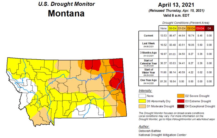
Reservoirs: (Bureau of Reclamation Reservoirs, State Reservoirs)
April is generally the time of the year when water managers across Montana start to fill the local, state
and federally managed reservoirs across Montana. It is also a time that leaves most water managers and
dam tenders feeling uneasy as they consider changing conditions and attempt to anticipate spring runoff
and water demands moving into the summer months. It is important to keep in mind that water
management in Montana isn’t only about water supplies here in Montana. This year, the warm and dry
winter combined with extreme drought conditions across much of the Northern Great Plains have
greatly reduced the threat of flooding farther down the Missouri River. According to the Army Corp of
Engineers, reservoir inflows in the Missouri River basin above Sioux City, Iowa (upper Basin) were well-
below average in March. The updated 2021 upper Missouri River Basin runoff forecast is 21.3 million
acre-feet (MAF), or 83% of average. As a result, river managers may consider reducing reservoir
releases this spring and hold back more water at federal water projects along the Missouri Mainstem.
Carryover was lower in Fresno Reservoir due to the failure of the St. Mary Canal in
2020. Storage is only 70 percent of average. There is also some concern about potentially reduced
inflows into Clark Canyon reservoir in southwest Montana due to the dry conditions that have carried
over from 2020, however, the reservoir elevation at Clark Canyon is currently above average.

Water elevations at state water projects across Montana are mostly average to above average. Nilan
reservoir is much below average due to draining the facility to accommodate dam repairs. The near
average snowpack and strong carry-over storage from last year suggests that most of Montana’s
reservoirs should fill this year. Below average snowpack in some basins provides some cause for
concern. Conditions for the smaller irrigator-controlled reservoirs in the western half of the State are
generally optimistic. Overall, reservoir storage is mostly average in the larger federal, state and local
facilities used for both irrigation and recreation as of April 1.

Storage in small reservoirs and stock water ponds in the eastern two-thirds of the state is low to very
low at the time of this writing. April, May and June are typically the wettest months of the year east of
the continental divide so there is still time to fill the many dug-outs, potholes, and small reservoirs that
many producers rely on for stockwater. Absent at least average precipitation this spring, many
producers are likely to have difficulty ensuring adequate drinking water supplies for livestock this
summer.

Drought Outlook:
As we move into spring, conditions in Montana couldn’t be more different today than they were one
year ago. In early April 2020, the U.S. Drought Monitor indicated that only 15% of the state was
abnormally dry. Currently, approximately 42% of the state is listed as abnormally dry; 23% is in the D1
(moderate) drought category; 10% is in the D2 (severe) drought; 8% of the area is in D3 (extreme)
drought which recently expanded to include parts of Phillips, Valley, Daniels, Sheridan, Roosevelt,
Richland, McCone, Wibaux, Prairie, Dawson, Fallon and Carter counties.

The current, abnormally dry and drought conditions across Montana are the result of the combination
of overly dry conditions prevalent last fall in addition to the warmer and drier than average conditions

Page |4
that characterized the winter. While there is still time to for conditions to improve, persistent dryness in
eastern Montana may result in continued deterioration of both stream and surface water availability
and soil moisture.

The next 8 to 10 weeks is a critical period. Despite the current drought status across much of Montana,
there really is time for conditions to improve prior to the onset of summer. In 20 of the last 21 years,
parts of Montana have been classified as abnormally dry or in a drought category in early April. In 10 of
those years, statewide drought conditions improved between early April and late June, but in 9 of them
conditions worsened. In one year, 2014, conditions remained about the same. 2005 offers a noteworthy
example. In early April of 2005, 86% of the state was listed in a D2 to D4 drought category. Despite a
drier than average April and May, an unusually wet June relieved drought conditions across the state
and by September 1st drought conditions had dissipated dramatically. The chances of improving versus
worsening drought conditions between early April and the end of June is about 50/50 and will likely vary
across of the state. Temperature could also play an outsized role in the equation as it did in 2017 which
saw temperatures of 8 to 12 degrees above average by mid-May of that year. Below is the most recent
map of the status of current drought classifications from the U.S. Drought Monitor.

Long Term Forecast:

The Climate Prediction Center, a division of the National Weather Service, provides long-term forecasts
for the contiguous United States, Alaska and Hawaii. The current temperature outlook for April calls for
a 33% chance of above average temperatures across most of Montana. The precipitation outlook does
not offer a clear signal that indicates above or below average precipitation across the state.

Page |5
1 Month Temperature Forecast:

1 Month Precipitation Forecast:

Page |6
Water Supply and Drought Outlook Summary

The generally warmer and drier than average weather in the fall and early winter of 2020 and the winter
of 2021 makes conditions difficult to interpret as we move into spring and summer. The unusually dry
and warm conditions in September, November and December of 2020; warmer than average and dry,
open winter across the low and mid elevations; the smattering of inconsistent yet large snow events
along with a spate of extremely cold temperatures and storms that generated a near average snowpack
makes for an unclear picture of where conditions stand today. It also makes a quick summation of
current conditions and what they portend for the next few months a difficult task verging on a fool’s
errand. The official outlook calls for drought conditions to persist. That is likely an accurate forecast. The
question at this point in the season is whether the rains of April, May and June bring some comfort and
prosperity or fail giving way to worry and hardship. As we enter the spring with moderate to extreme
drought conditions across nearly half of the state, chances for improved conditions between now and
the 4th of July are about 50/50 and will likely vary widely depending upon the specific locale.

Drought Evaluation Tools and Resources – The following resources provide useful tools that DNRC and
their partners use to evaluate drought and water supply conditions on a weekly basis across Montana.

Upper Missouri River Drought Indicators Dashboard
Montana Drought Impacts Reporter - Submit a report: https://nris.mt.gov/droughtsurvey
                                       View results: https://nris.mt.gov/droughtimpacts
NRCS Interactive Precip Portal
USGS Water Watch Dashboard
Montana Mesonet Data Downloader
Page |7
Working on behalf of the Governor's Drought and Water Supply Advisory Committee, DNRC has compiled this Spring Water Supply and Drought Outlook. This report provides a synopsis of statewide conditions gleaned from multiple sources and offers links to additional resources with more in-depth information. In partnership with other state and federal agencies and Tribes, experts in climate science, snowpack, streamflow and weather information collect and evaluate drought and water supply data on a weekly basis throughout the year. This information is distilled into weekly recommendations to the U.S. Drought Monitor which tracks drought conditions nationally. Much of the information contained in this report comes from the NRCS Water Supply Outlook Report, U.S. Drought Monitor, Climate Prediction Center, National Integrated Drought Information System and others. Please don't hesitate to contact Michael Downey, at DNRC (mdowney2@mt.gov) if you have any questions or feedback about any of the information contained in this report. Keep an eye out for the next drought update in late June. This report would not be possible without the ongoing participation and contributions of our local, university, state, tribal and federal partners, some of which are listed below: This report was developed by DNRC on behalf of the Governor’s Drought & Water Supply Advisory Committee pursuant to MCA 2-15-3308(5). Page |8
You can also read