Musgrave Commences High Powered EM Survey at Mamba
←
→
Page content transcription
If your browser does not render page correctly, please read the page content below
ASX RELEASE 29 April 2015
ASX: MGV
Musgrave Commences High Powered EM Survey
at Mamba
• High powered deep penetrating EM survey has commenced at the Mamba project
in the Fraser Range
• 11 high priority nickel-copper targets prioritised for ground EM
• Priority target M12 is associated with elevated platinum and palladium in shallow
historical aircore drilling. The M12 target is not effectively drill tested
• The Mamba nickel-copper project is in the same belt as the world class Nova-
Bollinger nickel-copper sulphide discoveries
• Target signatures consistent with mafic-ultramafic intrusive bodies, the
prospective host for nickel-copper sulphide mineralisation in the district
Musgrave Minerals Ltd (“Musgrave” or “the Company”)
(ASX:MGV) is pleased to announce the
commencement of a deep penetrating ground
electromagnetic (“EM”) survey on the wholly owned
Mamba Exploration Licence (E28/2405) in the Fraser
Range (Figure 1).
The ground EM survey will cover up to 11 priority
nickel-copper targets (Figure 2) identified through the
interpretation of detailed aeromagnetic and gravity and
geological data. The targets show magnetic
characteristics consistent with mafic-ultramafic intrusive
bodies, the prospective host for nickel-copper sulphide
mineralisation in the district.
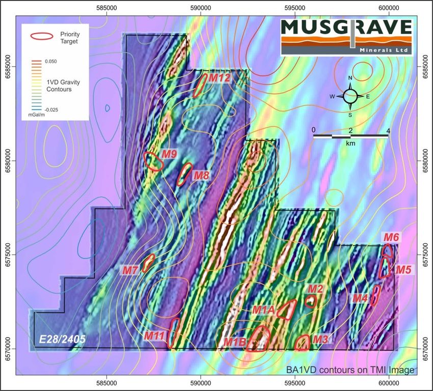
High priority target M12 (Figure 3) is very close to a
historical aircore drill hole (FRNAC663) with elevated
copper (78ppm) and very anomalous platinum and
palladium (Pd: 164ppb; Pt: 176ppb) from an end of hole
2m composite sample within weathered meta-gabbro at
a depth of 51-53m. The only multi-element sampling Figure 1: Mamba Project Location
28 Richardson Street, West Perth WA 6005
Telephone: (61 8) 9324 1061 Fax: (61 8) 9324 1014
Web: www.musgraveminerals.com.au Email: info@musgraveminerals.com.au
ACN: 143 890 671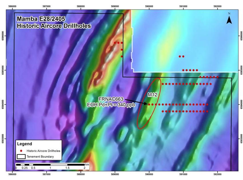
undertaken by the previous explorer was at the end of hole. Musgrave will resample the existing
drill spoils to confirm the anomaly. No historical drilling is present near any of the other targets.

The Mamba nickel-copper project is in
the same belt as the world class Nova-
Bollinger    nickel-copper    sulphide
discoveries of Sirius Resources NL in
south-eastern WA. The tenement is
located only 5km from the Trans
Australian rail line access corridor
(Figure 1).

Musgrave’s Managing Director Rob
Waugh said: “We are excited about
using this new high powered EM
system on our high priority nickel-
copper targets at Mamba. The quality
of the targets interpreted from the
detailed aeromagnetic survey and
regional gravity are very encouraging
in what is a highly prospective and
underexplored part of the Fraser
Range. The EM is the next critical step
in the exploration process.”
                                           Figure 2: Priority Targets on Detailed Aeromagnetic
                                           data

The high powered (150-200A) EM system being used has been developed to detect highly
conductive “Nova-Bollinger” style massive nickel-copper sulphide bedrock conductors to a depth of
more than 700m below surface. The system will be optimised to test individual targets. The
integration and interpretation of regional gravity data has helped prioritise individual targets
(Figure 2). A strong positive gravity response could reflect an accumulation of denser mafic
magma at depth, the potential host to nickel-copper sulphide mineralisation.

                                                            The targets comprise two broad target
                                                            styles     interpreted     from     the
                                                            aeromagnetic data (Figure 2) and
                                                            integrated with the regional gravity
                                                            data. The first style includes discrete
                                                            magnetic highs or lows interpreted to
                                                            be mafic/ultramafic intrusive bodies
                                                            prospective for magmatic nickel-copper
                                                            deposits and the second style includes
                                                            de-magnetised zones associated with
                                                            major structural intersections or fold
                                                            closures that could represent increased
                                                            areas of fluid flow and potential
                                                            mineralisation.

  Figure 3: Historical Aircore Drill Hole Locations on
  Detailed Aeromagnetic Image

                                                   2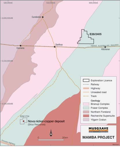
Follow-up Exploration

Follow-up exploration will include resampling of selected historical aircore drill holes followed by a
combination of aircore and reverse circulation (“RC”) drilling to test specific bedrock conductors to
identify the potential footprint of massive nickel-copper sulphide mineralisation.

The ground EM survey is expected to take approximately four weeks to complete with results
expected in early June. A heritage survey has been completed over the entire tenement in
preparation for drilling.

    Enquiries:
    Robert Waugh
    Managing Director
    Musgrave Minerals Ltd
    +61 8 9324 1061

    About Musgrave Minerals
    Musgrave Minerals Ltd is an active Australian base and precious metals explorer with a large exploration footprint in
    the Musgrave Province in South Australia and a new nickel-copper sulphide project in the highly prospective Fraser
    Range region of Western Australia. Musgrave has a powerful shareholder base with four mining and exploration
    companies participating as cornerstone investors.

    Competent Person’s Statement
    The information in this report that relates to Exploration Targets, Exploration Results, Mineral Resources or Ore
    Reserves is based on information compiled and/or thoroughly reviewed by Mr Robert Waugh, a Competent Person
    who is a Fellow of the Australasian Institute of Mining and Metallurgy (AusIMM) and a Member of the Australian
    Institute of Geoscientists (AIG). Mr Waugh is Managing Director and a full-time employee of Musgrave Minerals Ltd.
    Mr Waugh has sufficient experience that is relevant to the style of mineralisation and type of deposit under
    consideration to qualify as a Competent Person as defined in the 2012 Edition of the ‘Australasian Code for Reporting
    of Exploration Results, Mineral Resources and Ore Reserves’. Mr Waugh consents to the inclusion in the report of the
    matters based on his information in the form and context in which it appears.

                                                                  3
Mamba Project
                                                       JORC TABLE 1

                                  Section 1 Sampling Techniques and Data

  Criteria                               Explanation                                                Commentary
  Location of      Accuracy and quality of surveys used to locate drill holes     All maps and locations are in UTM grid (GDA94
  data points      (collar and down-hole surveys), trenches, mine workings        Z51) and have been measured by hand-held GPS
                   and other locations used in Mineral Resource estimation.       with an accuracy of ±4 metres.
                                                                                  EM survey loops and receiver data points are laid
                                                                                  out using handheld GPS units.
                                                                                  Topographic control with 2-5m accuracy using
                                                                                  published maps is considered sufficient for
                                                                                  modelling of EM survey results.

                   Specification of the grid system used.                         Co-ordinates are in UTM grid (GDA94 Z51)

                   Quality and adequacy of topographic control.                   Topographic control with 2-5m accuracy using
                                                                                  published maps and hand held GPS is considered
                                                                                  sufficient for modelling of EM survey results.

Data spacing       Data spacing for reporting of Exploration Results.             Loops are laid out as squares or rectangles
and                                                                               measuring either 1000x1000m or 1200x800m.
distribution                                                                      Receiver data is acquired at 50m intervals along
                                                                                  east–west oriented lines spaced at 150m intervals.

                   Whether the data spacing and distribution is sufficient to     The presence of mineralisation has not yet been
                   establish the degree of geological and grade continuity        demonstrated. There is no Mineral Resource or
                   appropriate for the Mineral Resource and Ore Reserve           Reserves under the classification applied in the
                   estimation procedure(s) and classifications applied.           2012 JORC Code.

                   Whether sample compositing has been applied.                   No sample has been undertaken.

Orientation of     Whether the orientation of sampling achieves unbiased          The precise dip and strike of mineralisation is not
data in relation   sampling of possible structures and the extent to which        yet known and it is unclear at this stage whether
to geological      this is known, considering the deposit type.                   any sampling has a set bias.
structure
                   If the relationship between the drilling orientation and the   The geological strike is highly variable due to post
                   orientation of key mineralised structures is considered to     emplacement deformation but the overall trend of
                   have introduced a sampling bias, this should be assessed       stratigraphy is north-east. No orientation based
                   and reported if material.                                      sampling bias is known at this time.

Audits or          The results of any audits or reviews of sampling               No external audits or reviews of modelling
reviews            techniques and data.                                           techniques and data have been undertaken.

                                 Section 2 Reporting of Exploration Results

  Criteria                               Explanation                                                Commentary
Mineral            Type, reference name/number, location and ownership            All data is within Mamba Project tenement
tenement and       including agreements or material issues with third parties     E28/2405 in the Fraser Range of Western
land tenure        such as joint ventures, partnerships, overriding royalties,    Australia located on Vacant Crown Land.
status             native title interests, historical sites, wilderness or
                                                                                  E28/2405 is owned 100% by Musgrave Minerals
                   national park and environmental settings.
                                                                                  Ltd.
                                                                                  At the time of writing the licence is granted for a 5
                                                                                  year period expiring on 4 February 2020.

                                                                                  There is no Native Title claim over the area
                                                                                  covered by the tenement.

                   The security of the tenure held at the time of reporting       The tenement application is in good standing and
                   along with any known impediments to obtaining a licence        no known impediments exist.
                   to operate in the area.

                                                                        4
Exploration Acknowledgment and appraisal of exploration by other Historical drilling on this tenement has been limited
done by other parties. to a small number of shallow aircore holes
parties covering a 2 km2 area in the north-east corner of
the tenement completed by Ponton Minerals Pty
Ltd.
Ponton Minerals Pty Ltd contracted Bostech
Drilling Pry Ltd to undertake 100m spaced aircore
drilling on a number of gold target area in 2012.
Gold sampling was undertaken using 3m
composites for the entire drill hole. A multi-element
sample (61 elements) was analysed as a 1-3m
composite at the end of hole.
Sample analysis was undertaken by Genalysis.
The following assay procedure was undertaken:
AR25/OES, AR25/MS and AR25/GF on 25g
homogenized samples.
Anomalous historical drill hole samples will need to
be confirmed through resampling from existing drill
spoils.
Refer Combined Partial Surrender Report Ponton
Project E28/1716, E28/1717, E28/1718, E28/1727
for the period 12th November 2007 to 8th
November 2013. Combined Reporting Number:
C196/2008 By: J. Sharp Ponton Minerals Pty Ltd
8th January 2014.
Geology Deposit type, geological setting and style of Musgrave is exploring for multi commodity style
mineralisation. deposits consistent with low MgO magmatic nickel-
copper sulphide systems and Proterozoic gold
mineralisation.
Drill hole A summary of all information material to the No drilling has been undertaken by the owner or
Information understanding of the exploration results including a referred to in this report.
tabulation of the following information for all Material drill
holes.
Data In reporting Exploration Results, weighting averaging No drilling has been undertaken by the owner or
aggregation techniques, maximum and/or minimum grade truncations referred to in this report.
methods (e.g. cutting of high grades) and cut-off grades are
usually Material and should be stated.
Relationship These relationships are particularly important in the No significant mineralisation has yet been
between reporting of Exploration Results. identified on the tenement
mineralisation
widths and
intercept
lengths
Diagrams Appropriate maps and sections (with scales) and Refer to figures in the body of this report.
tabulations of intercepts should be included for any
significant discovery being reported These should
include, but not be limited to a plan view of drill hole collar
locations and appropriate sectional views.
Balanced Where comprehensive reporting of all Exploration Results No drilling has been undertaken by the owner or
reporting is not practicable, representative reporting of both low referred to in this report.
and high grades and/or widths should be practiced to
avoid misleading reporting of Exploration Results.
5Other Other exploration data, if meaningful and material, should A fixed wing aeromagnetic and radiometric survey
substantive be reported including (but not limited to): geological was conducted over the entire tenement area of
exploration observations; geophysical survey results; geochemical E28/2405 by Thomson Aviation. The survey
data survey results; bulk samples – size and method of comprises 2136 line km of data, with an E-W line
treatment; metallurgical test results; bulk density, orientation at 100m line spacing and nominal
groundwater, geotechnical and rock characteristics; sensor height of 35-40m.
potential deleterious or contaminating substances.
The grid system used is GDA94 Z51
Current high-powered fixed loop electromagnetic
(HPFLEM) surveys are using variable loop
configurations but nominally 1000 x 1000m or
1200x800m, 50m stations and 150m lines. An
ORE HP transmitter producing >150A is used.
Base frequency for initial surveys – 0.5Hz, ZXY
(Z+Up, X+East, Y+North), EMIT SMARTfluxgate
B-Field sensor.
Further work The nature and scale of planned further work (e.g. tests A range of exploration techniques are being
for lateral extensions or depth extensions or large-scale considered to progress exploration including
step-out drilling). drilling.
Diagrams clearly highlighting the areas of possible Refer to figures in the body of this report.
extensions, including the main geological interpretations
and future drilling areas, provided this information is not
commercially sensitive.
6You can also read