National Park Service Geologic Type Section Inventory
←
→
Page content transcription
If your browser does not render page correctly, please read the page content below
National Park Service
U.S. Department of the Interior

Natural Resource Stewardship and Science

National Park Service Geologic Type Section
Inventory
Northeast Coastal and Barrier Inventory & Monitoring Network
Natural Resource Report NPS/NCBN/NRR—2021/2287
ON THE COVER
Lithified shelly sands of the type section bluff exposure of the Pliocene Moore House Member of the Yorktown Formation
along the southern bank of the York River, Colonial National Historic Park, Virginia. Photo courtesy of Mackenzie Chriscoe.
National Park Service Geologic Type Section
Inventory
Northeast Coastal and Barrier Inventory & Monitoring
Network
Natural Resource Report NPS/NCBN/NRR—2021/2287

Tim Henderson,1 Vincent L. Santucci1, Tim Connors2, and Justin S. Tweet3
1
 National Park Service
Geologic Resources Division
1849 “C” Street, NW
Washington, D.C. 20240
2
 National Park Service
Geologic Resources Division
Post Office Box 25287
Denver, Colorado 80225
3
 National Park Service
9149 79th Street S.
Cottage Grove, Minnesota 55016

August 2021

U.S. Department of the Interior
National Park Service
Natural Resource Stewardship and Science
Fort Collins, Colorado
The National Park Service, Natural Resource Stewardship and Science office in Fort Collins,
Colorado, publishes a range of reports that address natural resource topics. These reports are of
interest and applicability to a broad audience in the National Park Service and others in natural
resource management, including scientists, conservation and environmental constituencies, and the
public.

The Natural Resource Report Series is used to disseminate comprehensive information and analysis
about natural resources and related topics concerning lands managed by the National Park Service.
The series supports the advancement of science, informed decision-making, and the achievement of
the National Park Service mission. The series also provides a forum for presenting more lengthy
results that may not be accepted by publications with page limitations.

All manuscripts in the series receive the appropriate level of peer review to ensure that the
information is scientifically credible, technically accurate, appropriately written for the intended
audience, and designed and published in a professional manner.

This report received informal peer review by subject-matter experts who were not directly involved
in the collection, analysis, or reporting of the data.

Views, statements, findings, conclusions, recommendations, and data in this report do not necessarily
reflect views and policies of the National Park Service, U.S. Department of the Interior. Mention of
trade names or commercial products does not constitute endorsement or recommendation for use by
the U.S. Government.

This report is available in digital format from the Northeast Coastal and Barrier Inventory and
Monitoring Network and Natural Resource Publications Management websites. If you have difficulty
accessing information in this publication, particularly if using assistive technology, please email
irma@nps.gov.

Please cite this publication as:

Henderson, T., V. L. Santucci, T. Connors, and J. S. Tweet. 2021. National Park Service Geologic
Type Section Inventory: Northeast Coastal and Barrier Inventory & Monitoring Network. Natural
Resource Report NPS/NCBN/NRR—2021/2287. National Park Service, Fort Collins, Colorado.
https://doi.org/10.36967/nrr-2286992.

NPS 962/176938, August 2021
                                                    ii
Contents
                                                                                                                                                      Page

Figures.................................................................................................................................................... v

Tables ................................................................................................................................................... vii

Photographs.......................................................................................................................................... vii

Executive Summary .............................................................................................................................. ix

Acknowledgments................................................................................................................................. xi

Dedication ...........................................................................................................................................xiii

Introduction ............................................................................................................................................ 1

Geology and Stratigraphy of the NCBN I&M Network Parks .............................................................. 5

       Precambrian .................................................................................................................................... 6

       Paleozoic ........................................................................................................................................ 6

       Mesozoic ........................................................................................................................................ 6

       Cenozoic ......................................................................................................................................... 6

National Park Service Geologic Resource Inventory ............................................................................ 7

       GRI Products .................................................................................................................................. 7

            Geologic Map Data.................................................................................................................... 7

            Geologic Maps........................................................................................................................... 8

            Source Maps .............................................................................................................................. 8

       GRI GIS Data ................................................................................................................................. 8

       GRI Map Posters ............................................................................................................................ 9

       Use Constraints............................................................................................................................... 9

Methods................................................................................................................................................ 11

       Methodology................................................................................................................................. 11

       Definitions .................................................................................................................................... 16

Assateague Island National Seashore (ASIS) ...................................................................................... 17

Cape Cod National Seashore (CACO) ................................................................................................. 21

Colonial National Historical Park (COLO) ......................................................................................... 25
                                                                             iii
Contents (continued)
                                                                                                                                                Page

Page Fire Island National Seashore (FIIS)........................................................................................... 31

Gateway National Recreation Area (GATE) ....................................................................................... 35

George Washington Birthplace National Monument (GEWA) ........................................................... 39

Sagamore Hill National Historic Site (SAHI)...................................................................................... 43

Thomas Stone National Historic Site (THST) ..................................................................................... 47

Recommendations ................................................................................................................................ 51

Literature Cited .................................................................................................................................... 53

Appendix A: Source Information for GRI Maps of NCBN Parks ....................................................... 55

Appendix B: Geologic Time Scale ...................................................................................................... 59

                                                                          iv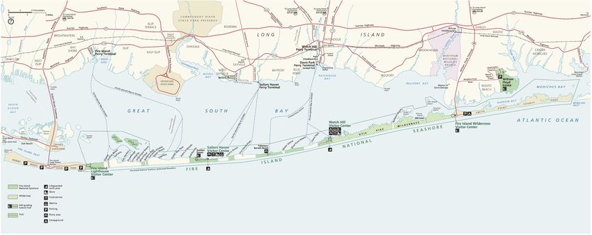
Figures
                                                                                                                                                  Page

Figure 1. Distribution of Northeast Coastal and Barrier I&M Network parks, including
Assateague Island National Seashore (ASIS), Cape Cod National Seashore (CACO),
Colonial National Historical Park (COLO), Fire Island National Seashore (FIIS),
Gateway National Recreation Area (GATE), George Washington Birthplace National
Monument (GEWA), Sagamore Hill National Historic Site (SAHI), and Thomas Stone
National Historic Site (THST) (NPS). ................................................................................................... 5

Figure 2. Screenshot of digital geologic map of Cape Cod National Seashore showing
mapped units. ....................................................................................................................................... 12

Figure 3. GEOLEX search result for the Moore House Member of the Yorktown
Formation. ............................................................................................................................................ 13

Figure 4. Stratotype inventory spreadsheet of the NCBN displaying attributes appropriate
for geolocation assessment. ................................................................................................................. 15

Figure 5. Park map of ASIS, Maryland–Virginia (NPS). ................................................................... 18

Figure 6. Geologic and geomorphologic map of ASIS, Maryland–Virginia. ..................................... 19

Figure 7. Park map of CACO, Massachusetts (NPS).......................................................................... 22

Figure 8. Geologic and geomorphologic map of CACO, Massachusetts. .......................................... 23

Figure 9. Park map of COLO, Virginia (NPS).................................................................................... 26

Figure 10. Geologic and geomorphologic map of COLO, Virginia. .................................................. 27

Figure 11. Modified geologic map of COLO showing stratotype locations. The
transparency of the geologic units layer has been increased. .............................................................. 28

Figure 12. Type section bluff exposure of the Moore House Member of the Yorktown
Formation along the southern bank of the York River, COLO ........................................................... 29

Figure 13. Shelly sand beds of the Moore House Member of the Yorktown Formation at
the type section exposure along the southern bank of the York River (ROWAN
LOCKWOOD). .................................................................................................................................... 30

Figure 14. Park map of FIIS, New York (NPS). ................................................................................. 32

Figure 15. Geologic and geomorphologic map of FIIS, New York.................................................... 33

Figure 16. Park map of GATE, New Jersey–New York (NPS). ......................................................... 36

Figure 17. Geologic and geomorphologic map of GATE, New Jersey–New York............................ 37

                                                                            v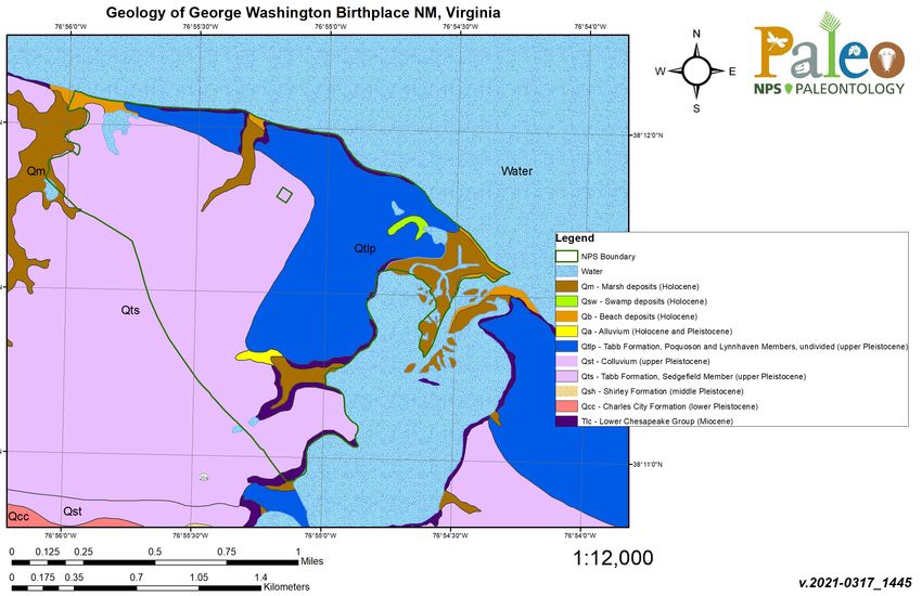
Figures (continued)
                                                                                                                                                  Page

Figure 18. Park map of GEWA, Virginia (modified from NPS map courtesy Rijk
Morawe). .............................................................................................................................................. 40

Figure 19. Geologic and geomorphologic map of GEWA, Virginia. ................................................. 41

Figure 20. Park map of SAHI, New York (NPS). ............................................................................... 44

Figure 21. Geologic and geomorphologic map of SAHI, New York. ................................................ 45

Figure 22. Park map of THST, Maryland (NPS). ............................................................................... 48

Figure 23. Geologic and geomorphologic map of THST, Maryland. ................................................. 49

                                                                           vi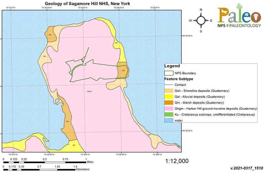
Tables
                                                                                                                                                Page

Table 1. List of COLO stratotype units sorted by age with associated reference
publications and locations. ................................................................................................................... 29

Photographs
                                                                                                                                                Page

Carmen Chapin ...................................................................................................................................xiii

Seth Lerman ........................................................................................................................................xiii

                                                                          vii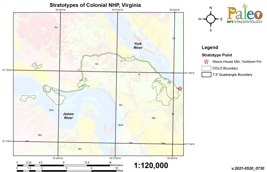
Executive Summary
A fundamental responsibility of the National Park Service (NPS) is to ensure that park resources are
preserved, protected, and managed in consideration of the resources themselves and for the benefit
and enjoyment by the public. Through the inventory, monitoring, and study of park resources, we
gain a greater understanding of the scope, significance, distribution, and management issues
associated with these resources and their use. This baseline of natural resource information is
available to inform park managers, scientists, stakeholders, and the public about the conditions of
these resources and the factors or activities that may threaten or influence their stability.

There are several different categories of geologic or stratigraphic units (supergroup, group,
formation, member, bed) that represent a hierarchical system of classification. The mapping of
stratigraphic units involves the evaluation of lithologies, bedding properties, thickness, geographic
distribution, and other factors. If a new mappable geologic unit is identified, it may be described and
named through a rigorously defined process that is standardized and codified by the professional
geologic community (North American Commission on Stratigraphic Nomenclature 2005). In most
instances when a new geologic unit such as a formation is described and named in the scientific
literature, a specific and well-exposed section of the unit is designated as the type section or type
locality (see Definitions). The type section is an important reference section for a named geologic
unit that presents a relatively complete and representative profile. The type or reference section is
important both historically and scientifically, and should be available for other researchers to
evaluate in the future. Therefore, this inventory of geologic type sections in NPS areas is an
important effort in documenting these locations in order that NPS staff recognize and protect these
areas for future studies.

The documentation of all geologic type sections throughout the 423 units of the NPS is an ambitious
undertaking. The strategy for this project is to select a subset of parks to begin research for the
occurrence of geologic type sections within particular parks. The focus adopted for completing the
baseline inventories throughout the NPS was centered on the 32 inventory and monitoring networks
(I&M) established during the late 1990s. The I&M networks are clusters of parks within a defined
geographic area based on the ecoregions of North America (Fenneman 1946; Bailey 1976; Omernik
1987). These networks share similar physical resources (geology, hydrology, climate), biological
resources (flora, fauna), and ecological characteristics. Specialists familiar with the resources and
ecological parameters of the network, and associated parks, work with park staff to support network
level activities (inventory, monitoring, research, data management).

Adopting a network-based approach to inventories worked well when the NPS undertook
paleontological resource inventories for the 32 I&M networks. The network approach is also being
applied to the inventory for the geologic type sections in the NPS. The planning team from the NPS
Geologic Resources Division who proposed and designed this inventory selected the Greater
Yellowstone Inventory and Monitoring Network (GRYN) as the pilot network for initiating this
project. Through the research undertaken to identify the geologic type sections within the parks of
the GRYN methodologies for data mining and reporting on these resources was established.

                                                   ix
Methodologies and reporting adopted for the GRYN have been used in the development of this type
section inventory for the Northern Coastal and Barrier Inventory & Monitoring Network.
The goal of this project is to consolidate information pertaining to geologic type sections that occur
within NPS-administered areas, in order that this information is available throughout the NPS to
inform park managers and to promote the preservation and protection of these important geologic
landmarks and geologic heritage resources. The review of stratotype occurrences for the NCBN
shows there are currently no designated stratotypes for ASIS, CACO, FIIS, GATE, GEWA, SAHI,
and THST; COLO has one type section.
This report concludes with a recommendation section that addresses outstanding issues and future
steps regarding park unit stratotypes. These recommendations will hopefully guide decision-making
and help ensure that these geoheritage resources are properly protected and that proposed park
activities or development will not adversely impact the stability and condition of these geologic
exposures.
xAcknowledgments
Many individuals were consulted in the preparation of this report on the geologic type sections for
the national parks of the Northeast Coastal and Barrier Inventory and Monitoring Network. We first
want to extend our sincere appreciation to Randy Orndorff, David Soller, and Nancy Stamm (U.S.
Geological Survey) for their assistance with this geologic type section inventory and other important
NPS projects. Randy, Nancy and David manage the National Geologic Map Database for the United
States (NGMDB, https://ngmdb.usgs.gov/ngm-bin/ngm_compsearch.pl?glx=1) and the U.S.
Geologic Names Lexicon (“GEOLEX”, https://ngmdb.usgs.gov/Geolex/search), critical sources of
geologic map information for science, industry and the American public.
We thank our colleagues and partners in the Geological Society of America (GSA) and Stewards
Individual Placement Program for their continued support to the NPS with the placement of interns
and other ventures. Additionally, we are grateful to Rory O’Connor-Walston and Alvin Sellmer from
the NPS Technical Information Center in Denver for their assistance with locating hard-to-find
publications.
Thanks to our NPS colleagues in the Northeast Coastal and Barrier Inventory and Monitoring
Network and various network parks, including Sara Nerone and Dennis Skidds (NCBN); Bill
Hulslander (ASIS); Geoff Sanders (CACO); Dorothy Geyer (COLO); Mike Bielecki (FIIS); Patricia
Rafferty (GATE); Melissa Cobern (GEWA); and David Lassman (THST). Additional thanks go to
Carmen Chapin and Seth Lerman for their continued support for this and other important geology
projects in the Northeast Region of the NPS (DOI Unified Region 1); Rowan Lockwood and Rick
Berquist, Jr. (William & Mary University); Mackenzie Chriscoe (William & Mary University; NPS
intern); Norbert Psuty (Rutgers University); and Stephen Godfrey (Calvert Marine Museum).
This project is possible through the support from research associates and staff in the National Park
Service Geologic Resources Division and we extend our thanks to Hal Pranger, Julia Brunner, Jason
Kenworthy, Rebecca Beavers, and Jim Wood.
xiDedication
This Northeast Coastal and Barrier Inventory and Monitoring Network Geologic Type Section
Inventory is dedicated to Carmen Chapin (Chief of Natural Resources) and Seth Lerman (Natural
Resources Support Coordinator) from Interior Region 1—North Atlantic Appalachian. We recognize
and appreciate the valuable support from Carmen and Seth for geology and paleontology issues in the
national parks within the parks of the North Atlantic Appalachian Region.
Carmen Chapin
Seth Lerman
xiiiIntroduction
The NPS Geologic Type Section Inventory Project (“Stratotype Inventory Project”) is a continuation
of, and complements the work performed by the Geologic Resources Inventory (GRI). The GRI is
funded by the NPS Inventory and Monitoring Program and administered by the Geologic Resources
Division (GRD). The GRI is designed to compile and present baseline geologic resource information
available to park managers, and advance science-informed management of natural resources in the
national parks. The goals of the GRI team are to increase understanding and appreciation of the
geologic features and processes in parks and provide robust geologic information for use in park
planning, decision making, public education, and resource stewardship.
Documentation of stratotypes (e.g., type sections/type localities/type areas) that occur within national
park boundaries represents a significant component of a geologic resource inventory, as these
designations serve as the standard for defining and recognizing geologic units (North American
Commission on Stratigraphic Nomenclature 2005). The importance of stratotypes lies in the fact that
they store information, represent important comparative sites where knowledge can be built up or
reexamined, and can serve as teaching sites for students (Brocx et al. 2019). The geoheritage
significance of stratotypes is analogous to that of libraries and museums, in that they are natural
reservoirs of Earth history spanning ~4.5 billion years and record the prodigious forces and evolving
life forms that define our planet and our understanding as a contributing species.
The goals of this project are to (1) systematically report the assigned stratotypes that occur within
national park boundaries, (2) provide detailed descriptions of the stratotype exposures and their
locations, and (3) reference the stratotype assignments from published literature. It is important to
note that this project cannot verify a stratotype for a geologic unit if one has not been formally
assigned and/or published. Additionally, numerous stratotypes are located geographically outside of
national park boundaries, but only those within 48 km (30 mi) of park boundaries will be presented
in this report.
This geologic type section inventory for the parks of the Northeast Coastal and Barrier Inventory &
Monitoring Network (NCBN) follows standard practices, methodologies, and organization of
information introduced in the Greater Yellowstone I&M Network type section inventory (Henderson
et al. 2020). All network-specific reports are prepared, peer-reviewed, and submitted to the Natural
Resources Stewardship and Science Publications Office for finalization. A small team of geologists
and paleontologists from the NPS Geologic Resources Division and the NPS Paleontology Program
have stepped up to undertake this important inventory for the NPS.
This inventory fills a current void in basic geologic information not currently compiled by the NPS
either at most parks and at the servicewide level. This inventory requires some intensive and strategic
data mining activities to determine instances where geologic type sections occur within NPS areas.
Sometimes the lack of specific locality or other data presents limitations in determining if a particular
type section is geographically located within or outside NPS administered boundaries. Below are the
primary considerations warranting this inventory of NPS geologic type sections.
1• Geologic stratotypes are a part of our national geologic heritage and are a cornerstone of the
scientific value used to define the societal significance of geoheritage sites
(https://www.nps.gov/articles/scientific-value.htm);
• Geologic stratotypes are important geologic landmarks and reference locations that define
important scientific information associated with geologic strata. Geologic formations are
commonly named after topographic or geologic features and landmarks that are recognizable
to park staff;
• Geologic stratotypes are both historically and scientifically important components of earth
science investigations and mapping;
• Understanding and interpretation of the geologic record depends upon the stratigraphic
occurrences of mappable lithologic units (formations, members). These geologic units are the
foundational attributes of geologic maps;
• Geologic maps are important tools for science, resource management, land use planning, and
other areas and disciplines;
• Geologic stratotypes are similar in nature to type specimens in biology and paleontology,
serving as a “gold standard” which helps to define characteristics used in classification;
• Geologic stratotypes within NPS areas have not been previously inventoried and there is a
general absence of baseline information for this geologic resource category;
• In general, NPS staff in parks are not aware of the concept of geologic type sections and
therefore may not understand the significance or occurrence of these natural landmarks in
parks;
• Given the importance of geologic stratotypes as geologic references and geologic heritage
resources, these locations should be afforded some level of preservation or protection when
they occur within NPS areas;
• If NPS staff are unaware of geologic type sections within parks, the NPS would not
proactively monitor the stability, condition, or potential impacts to these locations during
normal park operations or planning. The lack of baseline information pertaining to the
geologic type sections in parks is detrimental to the protection of these localities from
activities which may involve ground disturbance or construction. Therefore, consideration
needs to be given about how the NPS may preserve geologic type sections and better inform
NPS staff about their existence in the park;
• This inventory can inform important conversations on whether geologic stratotypes rise to the
level of national register documentation. The NPS should consider if any other legal
authorities (e.g., National Historic Preservation Act), policy, or other safeguards currently in
place can help protect geologic stratotypes that are established on NPS administered lands.
2Through this inventory, the associated report, and close communication with park and I&M
Network staff, the hope is there will be an increased awareness about these important
geologic landmarks in parks. In turn, the awareness of these resources and their significance
may be recognized in park planning and operations, to ensure that geologic stratotypes are
preserved and available for future study.
3Geology and Stratigraphy of the NCBN I&M Network Parks
The Northeast Coastal and Barrier Network (NCBN) consists of eight national park units along the
eastern coast of Maryland, Massachusetts, New Jersey, New York, and Virginia (Figure 1).
Assateague Island National Seashore (ASIS), Cape Cod National Seashore (CACO), Colonial
National Historical Park (COLO), Fire Island National Seashore (FIIS), Gateway National
Recreation Area (GATE), George Washington Birthplace National Monument (GEWA), Sagamore
Hill National Historic Site (SAHI), and Thomas Stone National Historic Site (THST) span the
northeast and mid-Atlantic Coastal Plain from Massachusetts in the north, to Virginia in the south.
The geographic distribution and low elevations of the NCBN parks along the Atlantic Ocean place
the network parks in the path of Atlantic storms and hurricanes, especially resources associated with
the barrier islands and seashores. Geologically, the NCBN are largely represented by surficial
deposits with limited exposures of Cenozoic bedrock (see Appendix B for a geologic time scale).
Consequently, only one geologic type section is identified for the parks of the NCBN.
Figure 1. Distribution of Northeast Coastal and Barrier I&M Network parks, including Assateague Island
National Seashore (ASIS), Cape Cod National Seashore (CACO), Colonial National Historical Park
(COLO), Fire Island National Seashore (FIIS), Gateway National Recreation Area (GATE), George
Washington Birthplace National Monument (GEWA), Sagamore Hill National Historic Site (SAHI), and
Thomas Stone National Historic Site (THST) (NPS).
5Precambrian
No Precambrian rocks are exposed at the surface within any of the NCBN parks.
Paleozoic
No Paleozoic rocks are exposed at the surface within any of the NCBN parks.
Mesozoic
No Mesozoic rocks are exposed at the surface within any of the NCBN parks. Late Cretaceous
coastal sediments are mapped subsurface (Raritan Formation) at SAHI.
Cenozoic
The oldest Cenozoic unit exposed within the NCBN is the early Eocene Nanjemoy Formation, a
shallow marine deposit exposed in THST. The early–middle Miocene Calvert Formation is exposed
in several of the mid-Atlantic parks including GATE, GEWA and THST. The late Miocene Eastover
Formation, a shallow marine unit, is exposed in COLO. The Pliocene Yorktown and Cold Harbor
Formations are also exposed at COLO.
In the NCBN, several Pleistocene map units in Virginia’s Coastal Plain are referred to as
alloformations, defined as sedimentary sequences bound by unconformities resulting from erosion
during sea level lowstand and deposition within drainages during marine transgressions (sea level
rise). Alloformations typically have a gravelly or coarse base possibly overlain by marsh or swamp
sediments, overlain by sand and clay (R. Berquist, William & Mary University, pers. comm., 2021).
Alloformations and formations may be used or understood as lithologic map units similarly.
Surficial Quaternary and Holocene units occur in most of the NCBN parks. However, most of these
units are not formally named. A few named Pleistocene formations or alloformations are mapped in
several parks, including the Bacons Castle Formation, Windsor Formation, Charles City
Alloformation, Chuckatuck Alloformation, Shirley Alloformation, Elsing Green Alloformation, and
Tabb Alloformation at COLO and late Pleistocene Tabb Alloformation at GEWA. The late
Pleistocene Sinepuxent Formation occurs in the subsurface at ASIS.
6National Park Service Geologic Resource Inventory
The Geologic Resources Inventory (GRI) provides digital geologic map data and pertinent geologic
information on park-specific features, issues, and processes to support resource management and
science-informed decision-making in more than 270 natural resource parks throughout the National
Park System. The GRI is one of 12 inventories funded by the National Park Service (NPS) Inventory
and Monitoring Program. The Geologic Resources Division (GRD) of the NPS Natural Resource
Stewardship and Science Directorate administers the GRI. The GRI team consists of a partnership
between the GRD and the Colorado State University Department of Geosciences to produce GRI
products.
GRI Products
The GRI team undertakes three tasks for each park in the Inventory and Monitoring program: (1)
conduct a scoping meeting and provide a summary document, (2) provide digital geologic map data
in a geographic information system (GIS) format, and (3) provide a GRI report. These products are
designed and written for non-geoscientists.
Scoping meetings bring together park staff and geologic experts to review and assess available
geologic maps, develop a geologic mapping plan, and discuss geologic features, processes, and
resource management issues that should be addressed in the GRI report. Scoping sessions were held
on the following dates for the NCBN parks: GEWA on July 25, 2005; THST on July 26, 2005; ASIS
on July 26–28, 2005; COLO on August 1, 2005; CACO on June 12–13, 2008; GATE on June 21,
2010; SAHI on June 23, 2010; and FIIS on June 24, 2010.
Following the scoping meeting, the GRI map team converts the geologic maps identified in the
mapping plan to GIS data in accordance with the GRI data model. After the map is completed, the
GRI report team uses these data, as well as the scoping summary and additional research, to prepare
the GRI report. As of 2021, GRI reports have been completed for ASIS, COLO, GEWA, and THST.
The GRI team conducts no new field work in association with their products.
The compilation and use of natural resource information by park managers is called for in the 1998
National Parks Omnibus Management Act (§ 204), 2006 National Park Service Management
Policies, and the Natural Resources Inventory and Monitoring Guideline (NPS-75). Additional
information regarding the GRI, including contact information, is available at
https://www.nps.gov/subjects/geology/gri.htm.
Geologic Map Data
A geologic map in GIS format is the principal deliverable of the GRI program. GRI GIS data
produced for the NCBN parks follows the selected source maps and includes components such as:
faults, mine area features, mine point features, geologic contacts, geologic units (bedrock, surficial,
glacial), geologic line features, structure contours, and so forth. These are commonly acceptable
geologic features to include in a geologic map.
7Posters display the data over imagery of the park and surrounding area. Complete GIS data are
available at the GRI publications website: https://www.nps.gov/subjects/geology/geologic-resources-
inventory-products.htm.
Geologic Maps
A geologic map is the fundamental tool for depicting the geology of an area. Geologic maps are two-
dimensional representations of the three-dimensional geometry of rock and sediment at, or beneath
the land surface (Evans 2016). Colors and symbols on geologic maps correspond to geologic map
units. The unit symbols consist of an uppercase letter indicating the geologic age and lowercase
letters indicating the formation’s name. Other symbols depict structures such as faults or folds,
locations of past geologic hazards that may be susceptible to future activity, and other geologic
features. Anthropogenic features such as mines or quarries, as well as observation or collection
locations, may be indicated on geologic maps. The American Geosciences Institute website
(https://www.americangeosciences.org/environment/publications/mapping) provides more
information about geologic maps and their uses.
Geologic maps are typically one of two types: surficial or bedrock. Surficial geologic maps typically
encompass deposits that are unconsolidated and which formed during the past 2.6 million years (the
Quaternary Period). Surficial map units are differentiated by geologic process or depositional
environment. Bedrock geologic maps encompass older, typically more consolidated sedimentary,
metamorphic, and/or igneous rocks. Bedrock map units are differentiated based on age and/or rock
type. GRI has produced various maps for the NCBN parks.
Source Maps
The GRI team does not conduct original geologic mapping. The team digitizes paper maps and
compiles and converts digital data to conform to the GRI GIS data model. The GRI GIS dataset
includes essential elements of the source maps such as map unit descriptions, a correlation chart of
units, a map legend, map notes, cross sections, figures, and references. These items are typically
included in a master geology document (PDF) for a specific park. The GRI team uses a unique
“GMAP ID” value for each geologic source map, and all sources used to produce the GRI GIS
datasets for the NCBN parks can be found in Appendix A.
GRI GIS Data
The GRI team standardizes map deliverables by using a data model. The most recent GRI GIS data
for ASIS, CACO, COLO, FIIS, GATE, and SAHI was compiled using data model version 2.2, which
is available at https://www.nps.gov/articles/gri-geodatabase-model.htm; the GEWA and THST data
are based on older data models and need to be upgraded to the most recent version. The data model
dictates GIS data structure, including layer architecture, feature attribution, and relationships within
ESRI ArcGIS software. The GRI website (https://www.nps.gov/subjects/geology/gri.htm) provides
more information about the program’s products.
GRI GIS data are available on the GRI publications website
(https://www.nps.gov/subjects/geology/geologic-resources-inventory-products.htm) and through the
NPS Integrated Resource Management Applications (IRMA) Data Store portal
8(https://irma.nps.gov/DataStore/Search/Quick). Enter “GRI” as the search text and select ASIS,
CACO, COLO, FIIS, GATE, GEWA, SAHI, or THST from the unit list.
The following components are part of the data set:
• A GIS readme file that describes the GRI data formats, naming conventions, extraction
instructions, use constraints, and contact information;
• Data in ESRI geodatabase GIS format;
• Layer files with feature symbology;
• Federal Geographic Data Committee (FGDC)-compliant metadata;
• An ancillary map information document that contains information captured from source maps
such as map unit descriptions, geologic unit correlation tables, legends, cross-sections, and
figures;
• ESRI map documents that display the GRI GIS data; and
• A version of the data viewable in Google Earth (.kml / .kmz file).
GRI Map Posters
Posters of the GRI GIS draped over shaded relief images of the park and surrounding area are
included in GRI reports. Not all GIS feature classes are included on the posters. Geographic
information and selected park features have been added to the posters. Digital elevation data and
added geographic information are not included in the GRI GIS data, but are available online from a
variety of sources. Contact GRI for assistance locating these data.
Use Constraints
Graphic and written information provided in this report is not a substitute for site-specific
investigations. Ground-disturbing activities should neither be permitted nor denied based upon the
information provided. Please contact GRI with any questions.
Minor inaccuracies may exist regarding the locations of geologic features relative to other geologic
or geographic features on the posters. Based on the source map scales (1:100,000, 1:62,500, and
1:24,000) and US National Map Accuracy Standards, geologic features represented in the geologic
map data are expected to be horizontally within 51 m (167 ft), 32 m (104 ft), and 12 m (40 ft),
respectively, of their true locations.
9Methods
This section of the report presents the methods employed and definitions adopted during this
inventory of geologic type sections located within the administrative boundaries of the parks in the
NCBN. This report is part of a more extensive inventory of geologic type sections throughout the
National Park System. Therefore, the methods, definitions, and challenges identified here pertain not
only to the parks of the NCBN, but also to other inventory and monitoring networks and parks.
There are a number of considerations to be addressed throughout this inventory. The most up-to-date
information available is necessary, either found online or in published articles and maps.
Occasionally, there is a lack of specific information that limits the information contained in the final
report. This inventory does not include any field work and is dependent on the existing information
related to individual park geology and stratigraphy. Additionally, this inventory does not attempt to
resolve any unresolved or controversial stratigraphic interpretations, which is beyond the scope of the
project.
Stratigraphic nomenclature may change over time with refined stratigraphic field assessments and
discovery of information through the expansion of stratigraphic mapping and measured sections. One
important observation regarding stratigraphic nomenclature relates to differences in use of geologic
names for units that transcend state boundaries. Geologic formations and other units that cross state
boundaries may be referenced with different names in each of the states where the units are mapped.
An example would be the Triassic Chugwater Formation in Wyoming, which is equivalent to the
Spearfish Formation in the Black Hills of South Dakota.
The lack of a designated and formal type section, or inadequate and vague geospatial information
associated with a type section, limits the ability to capture precise information for this inventory. The
available information related to the geologic type sections is included in this report.
Finally, it is worth noting that this inventory report is intended for a wide audience, including NPS
staff who might not have a background in geology. Therefore, this document has been developed as a
reference document that supports science, resource management, and a historic framework for
geologic information associated with NPS areas.
Methodology
The process of determining whether a specific stratotype occurs in an NPS area involves multiple
steps. The process begins with an evaluation of the existing park-specific GRI map to prepare a full
list of recognized map units (Figure 2).
11Figure 2. Screenshot of digital geologic map of Cape Cod National Seashore showing mapped units.
12Each map unit name is then queried in the U.S. Geologic Names Lexicon online database
(“GEOLEX”, a national compilation of names and descriptions of geologic units) at
https://ngmdb.usgs.gov/Geolex/search. Information provided by GEOLEX includes unit name,
stratigraphic nomenclature usage, geologic age, and published stratotype location descriptions, and
the database provides a link to significant publications as well as the USGS Geologic Names
Committee Archives (Wilmarth 1938; Keroher et al. 1966). Figure 3 below is taken from a search on
the Moore House Member unit.
Figure 3. GEOLEX search result for the Moore House Member of the Yorktown Formation.
Published GEOLEX stratotype spatial information is provided in three formats: (1) descriptive, using
distance from nearby points of interest; (2) latitude and longitude coordinates; or (3)
Township/Range/Section (TRS) coordinates. TRS coordinates are based on subdivisions of a single
93.2 km2 (36 mi2) township into 36 individual 2.59 km2 (1 mi2) sections, and were converted into
13Google Earth (.kmz file) locations using Earth Point
(https://www.earthpoint.us/TownshipsSearchByDescription.aspx). The most accurate GEOLEX
descriptions using TRS coordinates can help locate features within 0.1618 km2 (0.0625 mi2). Once
stratotype locality information provided for a given unit is geolocated using Google Earth, a GRI
digital geologic map of the national park is draped over it. This step serves two functions: to improve
accuracy in locating the stratotype, and validating the geologic polygon for agreement with
GEOLEX nomenclature. Geolocations in Google Earth are then converted into an ArcGIS format
using a “KML to Layer” conversion tool in ArcMap.
After this, a Microsoft Excel spreadsheet is populated with information pertinent to the geologic unit
and its stratotype attributes. Attribute data recorded in this way include: (1) is a stratotype officially
designated; (2) is the stratotype on NPS land; (3) has it undergone a quality control check in Google
Earth; (4) reference of the publication citing the stratotype; (5) description of geospatial information;
(6) coordinates of geospatial information; (7) geologic age (era, period, epoch, etc.); (8) hierarchy of
nomenclature (supergroup, group, formation, member, bed, etc.); (9) was the geologic unit found in
GEOLEX; and (10) a generic notes field (Figure 4).
14Figure 4. Stratotype inventory spreadsheet of the NCBN displaying attributes appropriate for geolocation assessment.
15Definitions
In order to clarify, standardize, and consistently reference stratigraphic concepts, principles, and
definitions, the North American Stratigraphic Code is recognized and adopted for this inventory. This
code describes explicit practices for classifying and naming all formally defined geologic units. An
important designation for a geologic unit is known as a stratotype–the standard exposure (original or
subsequently designated) for a named geologic unit or boundary that constitutes the basis for
definition or recognition of that unit or boundary (North American Commission on Stratigraphic
Nomenclature 2005). There are several variations of stratotype referred to in the literature and this
report, and they are defined as follows:
1) Unit stratotype: the type section for a stratified deposit or the type area for a non-stratified
body that serves as the standard for recognition and definition of a geologic unit (North
American Commission on Stratigraphic Nomenclature 2005). Once a unit stratotype is
assigned, it is never changed. The term “unit stratotype” is commonly referred to as “type
section” and “type area” in this report.
2) Type locality: the specific geographic locality encompassing the unit stratotype of a formally
recognized and defined unit. On a broader scale, a type area is the geographic territory
encompassing the type locality. Before development of the stratotype concept, only type
localities and type areas were designated for many geologic units that are now long- and
well-established (North American Commission on Stratigraphic Nomenclature 2005).
3) Reference sections: for well-established geologic units for which a type section was never
assigned, a reference section may serve as an invaluable standard in definitions or revisions.
A principal reference section may also be designated for units whose stratotypes have been
destroyed, covered, or are otherwise inaccessible (North American Commission on
Stratigraphic Nomenclature 2005). Multiple reference sections can be designated for a single
unit to help illustrate heterogeneity or some critical feature not found in the stratotype.
Reference sections can help supplement unit stratotypes in the case where the stratotype
proves inadequate (North American Commission on Stratigraphic Nomenclature 2005).
4) Lithodeme: the term “lithodeme” is defined as a mappable unit of plutonic (igneous rock that
solidified at great depth) or highly metamorphosed or pervasively deformed rock and is a
term equivalent in rank to “formation” among stratified rocks (North American Commission
on Stratigraphic Nomenclature 2005). The formal name of a lithodeme consists of a
geographic name followed by a descriptive term that denotes the average modal composition
of the rock (example: Cathedral Peak Granodiorite). Lithodemes are commonly assigned type
localities, type areas, and reference localities.
16Assateague Island National Seashore (ASIS) Assateague Island National Seashore (ASIS) is located within the Atlantic Coastal Plain physiographic province on the Delmarva (Delaware–Maryland–Virginia) Peninsula in Worcester County, Maryland and Accomack County, Virginia (Figure 5). Established on September 21, 1965, ASIS encompasses approximately 16,732 hectares (41,347 acres) of the Atlantic Coast (Anderson 2017). The National Seashore protects 60 km (37 mi) of sandy beaches, salt marshes, dunes, maritime forest, surrounding ocean, and bay waters for public outdoor recreation use and enjoyment (Anderson 2017). Dynamic coastal processes such as waves, wind, and tides continuously reshape the barrier island landscape. Visitors to ASIS can explore a wide range of recreational opportunities that include crabbing, surf fishing, bicycling, hiking, horseback riding, camping, swimming, and wildlife viewing. The geology of ASIS consists of young, unconsolidated or partially consolidated sediments such as sand, silt, and clay that are Holocene (
Figure 5. Park map of ASIS, Maryland–Virginia (NPS).

                                                18
Figure 6. Geologic and geomorphologic map of ASIS, Maryland–Virginia.
19Cape Cod National Seashore (CACO)
Cape Cod National Seashore (CACO) is located along the Atlantic-facing eastern shore of Cape Cod
in Barnstable County, Massachusetts (Figure 7). Established June 1, 1966, CACO protects
approximately 17,647 hectares (43,607 acres) of sandy beaches, dunes, woodlands, freshwater ponds,
and salt marshes that stretch nearly 64 km (40 mi) from Chatham to Provincetown (Anderson 2017).
CACO contains numerous cultural resources that include archeological sites, lighthouses, cultural
landscapes, the Old Harbor Life-Saving Station Museum, and the historic Marconi Station Site where
transatlantic wireless communication was achieved in 1903. Visitors at CACO can enjoy a wide
range of recreational activities that include swimming, fishing, hiking, bicycling, canoeing,
snorkeling, and sightseeing.
The coastal landscape of CACO is about 15,000 years old, making the national seashore a
geologically new landform (Giese et al. 2015). The geology of CACO consists of unconsolidated and
partially consolidated sediments of gravel, sand, silt, and mud deposited by ice sheets of Wisconsinan
age (~75,000–11,000 years ago) (Figure 8; Giese et al. 2015). Since the last glacial retreat, climate-
related change has produced a global sea level rise of approximately 400 m (120 m) that has
submerged much of the former coast that once extended ~6.4 km (4.0 mi) seaward of its present
location. The modern coastal landforms of CACO are temporary holding patterns that will inevitably
change due to the dynamic processes of wind, waves, and human activities.
As of the writing of this paper, there are no designated stratotypes identified within the boundaries of
CACO. There are no identified stratotypes located within 48 km (30 mi) of CACO boundaries.
21Figure 7. Park map of CACO, Massachusetts (NPS).
22Figure 8. Geologic and geomorphologic map of CACO, Massachusetts.
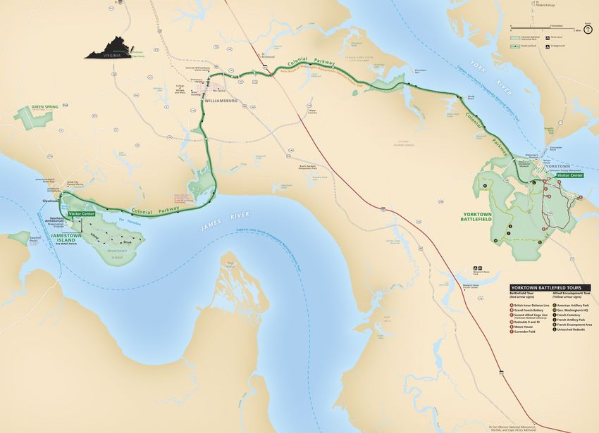
23Colonial National Historical Park (COLO)
Colonial National Historical Park (COLO) is situated in the Coastal Plain physiographic province
and spans the Virginia Peninsula between the James and York Rivers in Williamsburg City and
James and York Counties, Virginia (Figure 9). Originally established as Colonial National
Monument on December 30, 1930, COLO was re-designated as a park on June 5, 1936 (Anderson
2017). The park encompasses approximately 3,511 hectares (8,677 acres) of significant historic
resources that commemorate the origins of America as well as natural resources that include
wetlands, upland forests, bluffs, fields, streams, and shorelines. Seven historic units comprise COLO:
1) historic Jamestown, the site of America’s first permanent English settlement in 1607; 2) Yorktown
Battlefield, the backdrop of the 1781 culminating battle of the American Revolutionary War; 3) the
37 km (23 mi)-long Colonial Parkway; 4) Green Spring Plantation; 5) Cape Henry Memorial, the
first landing site of the Jamestown colonists in 1607; 6) Tyndall’s Point; and 7) Swann’s Point
(Thornberry-Ehrlich 2016).
The geology of COLO is representative of the Coastal Plain province and predominantly consists of
soft, mostly unconsolidated to partially consolidated sediments that were shed from the Appalachian
Mountains to the west (Bailey 1999). The eroded sediments form a thick wedge of sediments that
extend the plain eastward and are dominated by a series of step-wise river terraces that locally
decrease in elevation toward the Chesapeake Bay (Thornberry-Ehrlich 2016). Geologic units of
COLO range in age from the Miocene Eastover Formation (~11 million years old) to recent deposits
associated with salt marshes, swamps, and rivers (Figure 10; Ward and Blackwelder 1980). The
geologic foundations of COLO have strongly influenced the history of the region, from the
prehistoric American Indian inhabitants to the early European settlements and American struggles for
independence and unity during the American Revolutionary and Civil wars (Thornberry-Ehrlich
2016).
COLO contains one identified stratotype: the Pliocene Moore House Member of the Yorktown
Formation (Figure 11; Table 1). In addition to the designated stratotypes located within COLO, a list
of stratotypes located within 48 km (30 mi) of park boundaries is included here for reference. These
nearby stratotypes include the Miocene Eastover Formation (type section), Claremont Manor
Member of the Eastover Formation (type section), and Cobham Bay Member of the Eastover
Formation (type section); the Pliocene Bacons Castle Formation (type section), Barhamsville
member of the Bacons Castle Formation (type section), Yorktown Formation (principal reference
section), Yorktown Formation (coquina facies reference section), Sunken Meadow Member of the
Yorktown Formation (type section), Rushmere Member of the Yorktown Formation (type locality),
and Morgarts Beach Member of the Yorktown Formation (type section); and the Pleistocene
Chuckatuck Alloformation (type section), Poquoson Allomember of the Tabb Alloformation (type
section), Sedgefield Allomember of the Tabb Alloformation (type section), Lynnhaven Allomember
of the Tabb Alloformation (type section), Charles City Alloformation (type section), Shirley
Alloformation (type section), Elsing Green Alloformation (type section), and Windsor Alloformation
(type section).
25Figure 9. Park map of COLO, Virginia (NPS).
26Figure 10. Geologic and geomorphologic map of COLO, Virginia.
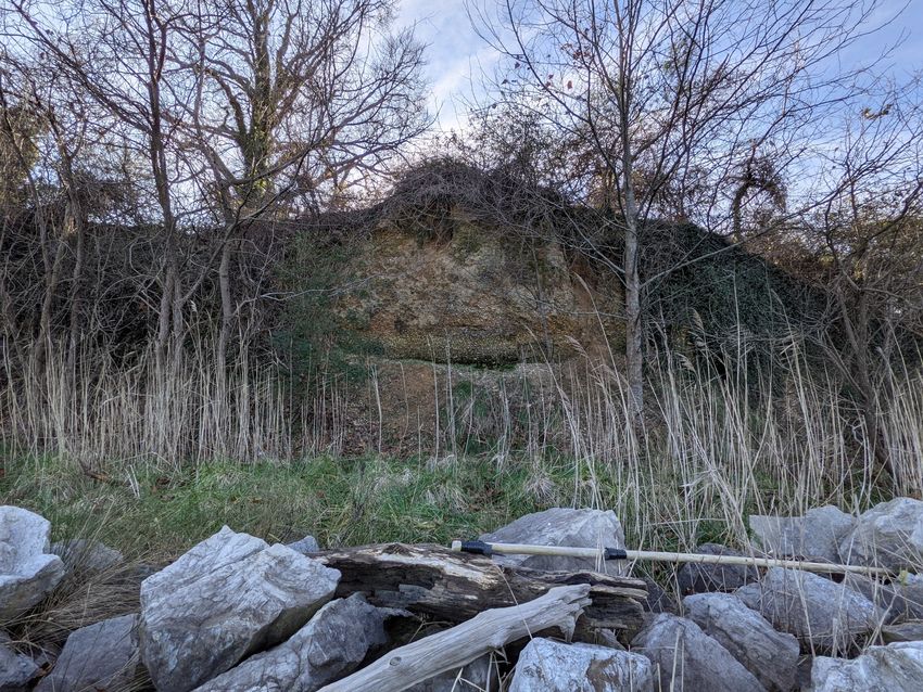
27Figure 11. Modified geologic map of COLO showing stratotype locations. The transparency of the geologic units layer has been increased.
28Table 1. List of COLO stratotype units sorted by age with associated reference publications and
locations.
Unit Name (map symbol) Reference Stratotype Location Age
Moore House Member, Ward and Type section: Bluffs at the Moore House, south late Pliocene
Yorktown Formation (Tymh) Blackwelder 1980 bank of the York River, in the Colonial National
Historical Park, York County, Virginia.
[Poquoson West 7 1/2-minute Quadrangle]
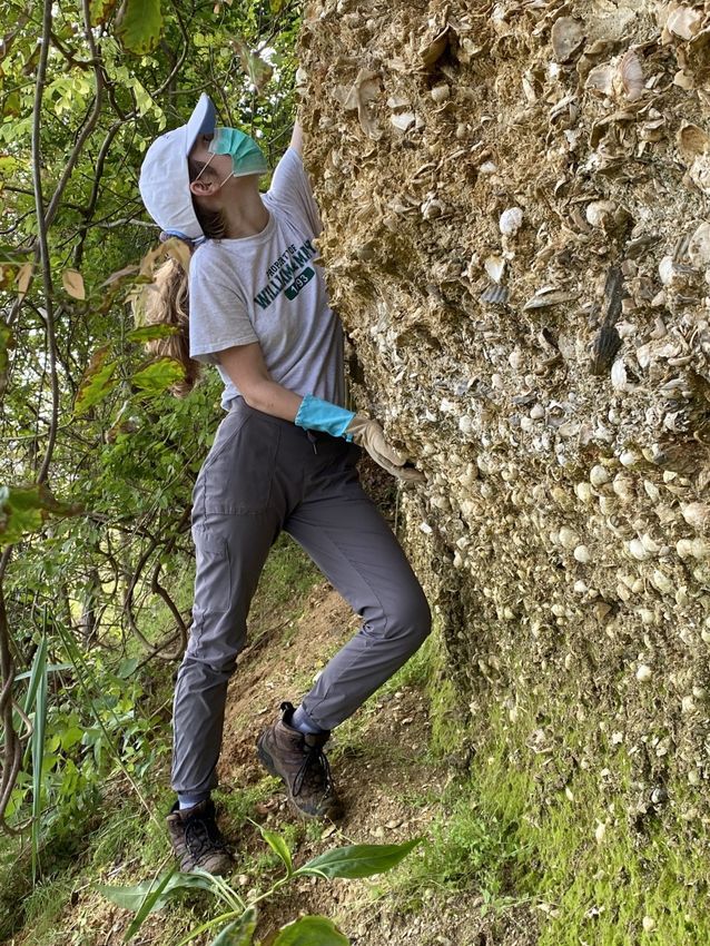
The Pliocene Moore House Member of the Yorktown Formation was named by Ward and
Blackwelder (1980) after the historic Moore House in COLO. Ward and Blackwelder (1980)
designated the type section at the bluffs just north of the Moore House, situated along the southern
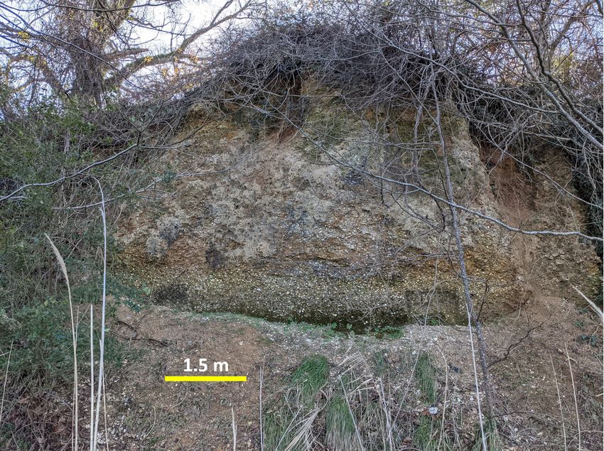
bank of the York River in York County, Virginia (Figures 11 and 12; Table 1). The type section
exposure measures approximately 8 m (26 ft) thick and consists of orange, fragmental, sandy shell
beds and cross-bedded shell hash that is locally cemented and contains disarticulated fossils of
bryozoans and mollusks (Figure 13; Ward and Blackwelder 1980). Stratigraphically, the Moore
House Member conformably overlies the Morgarts Beach Member in its outcrop area and the upper
contact is not exposed (Ward and Blackwelder 1980).
Figure 12. Type section bluff exposure of the Moore House Member of the Yorktown Formation along the
southern bank of the York River, COLO. Scale bar is 1.5 m (5 ft) (MACKENZIE CHRISCOE).
29Figure 13. Shelly sand beds of the Moore House Member of the Yorktown Formation at the type section
exposure along the southern bank of the York River (ROWAN LOCKWOOD).
30Fire Island National Seashore (FIIS)
Fire Island National Seashore (FIIS) encompasses a 42 km (26 mi) section of Fire Island, a barrier
island separated from Long Island by the Great South Bay in Suffolk County, New York (Figure 14).
Established on September 11, 1984, FIIS protects approximately 7,923 hectares (19,580 acres) of
cultural and natural resources that include sandy beaches, dunes, intertidal scrub, maritime forest,
wetlands, the Fire Island Lighthouse, and the William Floyd Estate. The William Floyd Estate, once
home to the signer of the Declaration of Independence, was authorized as an addition to FIIS in 1978
and preserves 250 years of history. Visitors to FIIS can explore a diverse range of recreational
activities that include swimming, boating, beachcombing, birdwatching, fishing, camping, hiking,
stargazing, and wildlife gazing.
Situated in the Atlantic Coastal Plain physiographic province, the geology of FIIS is dominated by
young, unconsolidated, and partially consolidated sediments of gravel, sand, silt, and mud. Much of
the barrier island is composed of recent dune sand, beach deposits, and swamp and marsh deposits
(Figure 15). The oldest geologic units in FIIS are represented by Pleistocene-age (~30,000 years old)
outwash deposits from ice along the Ronkonkoma Drift with outcrops of the Manhasset Formation
located at the William Floyd Estate on the mainland of Long Island (Frye et al. 1968; Sirkin 1982).
Dynamic coastal processes such as wind, waves, tides, and human interaction, in combination with
the geologic foundation of FIIS, help control the shape and distribution of the diverse habitats that
make up the Seashore.
As of the writing of this paper, there are no designated stratotypes identified within the boundaries of
FIIS. There are no identified stratotypes located within 48 km (30 mi) of FIIS boundaries.
31You can also read