Appendix - Protected Area Solutions
←
→
Page content transcription
If your browser does not render page correctly, please read the page content below
Appendix

           i
Appendix 1. A brief history of national park selection in Queensland
Queensland’s first national park was created at Witches
Falls, Mount Tamborine in March 1908. The hard work
of a small number of visionaries, backed by strong
public support, resulted in some important national
parks being declared in the first half of the twentieth
century. Most early national parks included spectacular
scenery, but also conserved areas of very high
biodiversity. The movement to select national parks
on a systematic and scientific basis began as early as
1964, when the Department of Forestry Annual Report
stated that ‘an important objective of the national parks
system must be to reserve permanently examples of all
the main environments including the less scenic’.
The coordinated effort to establish a representative
system of national parks evolved during the late
1960s and 1970s when scientists led the first projects
to systematically assess and conserve Australia’s
biodiversity1,2. In 1977, to establish a systematic
framework for conservation, a bioregional approach
was developed. In ground-breaking work, 13
biogeographic regions were identified in Queensland,
and key areas were assessed and proposed for
reservation (see the box on the bioregional approach
for more details)3.
By 1980, there was a significant spread of national
parks across Queensland—from the Simpson Desert
in the west and the Barrier Reef islands in the east
to the rainforests of Iron Range in the north, and the
dunes and wallum heath of Cooloola and Fraser Island

                                                                                                                           George Gentry
in the south. All of these areas have exceptionally high
value in conserving nature, but also exhibit scenic
beauty and offer a range of recreational opportunities.
In reserving these lands, significant progress towards
conservation was also made, as by then an estimated                       Visitors to Lamington National Park 1938.
40 per cent of the state’s ecosystem types were to some
extent reserved in parks covering 2.5 million hectares4.
However, there was an increasing realisation that few
protected areas existed in many bioregions, especially
in the western areas.
By 1985, the parks system had been reviewed
to determine which natural systems remained
unrepresented in each of these bioregions. Using
new computer-based programs, QPWS undertook                                 Comprehensive, adequate and representative
innovative planning projects to systematically identify                     protected area system
conservation priorities in the Channel Country, the                         Comprehensive means the system samples
Mulga Lands and the southern Brigalow Belt. During                          the full range of regional ecosystems across
this work, the concept of regional ecosystems was                           the landscape.

1    Specht R, Roe, E.M. & Broughton VH 1974. ‘Conservation of major
                                                                            Adequate means the protected areas are
     plant communities in Australia and Papua New Guinea’, Australian       of sufficient size and appropriate shape to
     Journal of Botany supplementary series, vol. 7.                        enable natural integrity, including species
2    Fenner F (Ed.) 1975, A national system of ecological reserves in       diversity, to be maintained.
     Australia, Australian Academy of Science, Canberra.
                                                                            Representative means the samples
3    Stanton JP & Morgan MG 1977, The rapid appraisal of key and            of regional ecosystems include the
     endangered sites. Report to the Department of Environment, Housing
     and Community Development University of New England, Armidale
                                                                            maximum possible diversity of their
                                                                            plant and animal communities.
4    Sattler P 1986, ‘Nature conservation in Queensland: Planning the
     matrix’, Proceedings of the Royal Society of Queensland, vol. 97.

ii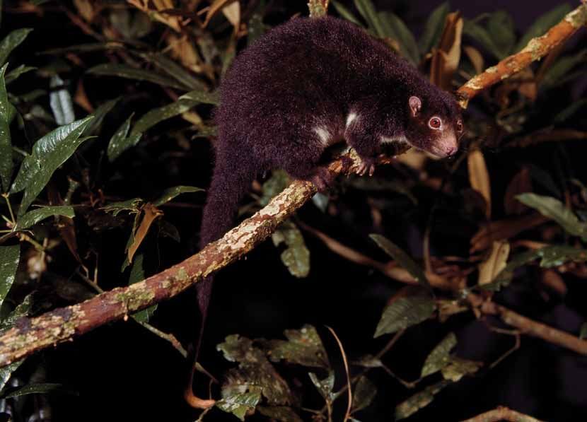
Appendix

  developed. These were defined across the state and                   The 1975 action recognised the importance of
  progressively mapped in each bioregion as a basis for more           conserving Queensland’s natural heritage and helped
  detailed and focused reserve planning.                               establish QPWS’ goals to:
  In the 1990s, recognition of skewed protected area                   • protect natural conditions
  coverage throughout Australia (the vast majority were
                                                                       • ensure rare and threatened plant and animal
  in coastal areas) led to Commonwealth, state and
                                                                         species are protected
  territory governments committing to the establishment
  of a nation-wide comprehensive, adequate and                         • provide facilities for minimal impact and nature-
  representative (CAR) system of protected areas.                        based recreation
  Queensland worked towards this commitment by
                                                                       • protect protected areas from overuse
  increasing representation of regional ecosystems. Many
  new protected areas were declared across the state in                • concentrate human activity in less sensitive areas
  the 1990s, including large national parks in western                 • help visitors enjoy special attractions and
  bioregions such as Diamantina, Astrebla and Idalia.                    understand conservation objectives.
  Since that time there has been a steady increase in                  Since it was first espoused in the Forestry Act 1959,
  national parks (including those in the high-biodiversity             and repeated in subsequent Acts, the cardinal principle
  coastal bioregions) resulting from forest transfers and              for the management of national parks has guided and
  other programs. Detailed planning work has been used                 determined how those parks can be used. That important
  to define important forest areas for conservation in the             principle states: ‘a national park is to be managed to
  South East Queensland and Wet Tropics bioregions and                 provide, to the greatest possible extent, for the permanent
  in the western hardwood forests.                                     preservation of the area’s natural condition and the
  Queensland now has more than eight million hectares of               protection of the area’s cultural resources and values’.
  land protected in national parks, which attract significant          The enactment of the Nature Conservation Act 1992
  numbers of international and domestic visitors every year.           broadened the scope of Queensland’s protected area
  The Queensland Parks and Wildlife Service (QPWS) was                 estate. National parks, conservation parks and resources
  established in 1975 to select, administer and manage                 reserves in 2011 account for approximately 4.95 per cent of
  these national parks for the benefit of present and                  land in Queensland. By 2020, the Queensland Government
  future generations. The move to bring parks and wildlife             aims to protect 50 per cent more land than that protected in
  together under one department followed a period of 67                2008 for nature conservation and public recreation.
  years during which national parks were administered by               This important Toward Q2 target reinforces a proud history
  the Department of Forestry.                                          of protecting Queensland’s exceptional and diverse plants,
                                                                       animals, landscapes, scenery, and cultural heritage.

                  9,000,000

                  8,000,000

                  7,000,000

                  6,000,000
Area (hectares)

                  5,000,000

                  4,000,000

                  3,000,000

                  2,000,000

                  1,000,000

                          1900   1910   1920   1930   1940   1950      1960    1970     1980     1990     2000     2010

                                                                Year

  Figure 1. National park area growth in Queensland from 1900 to 2011.

                                                                                                                                 iii
The bioregional approach

                                                                                                                                  DERM
Systematic planning for Queensland’s terrestrial
protected area system over the past 30 years has
been based on the bioregional framework, which was
initially devised in 1977 by Stanton and Morgan5,
described in Sattler and Williams in 1999, and used as
the basis of the Interim Biogeographic Regionalisation
of Australia (IBRA) and the National Reserve System.
The bioregional framework has been used to develop
the concept, used throughout Australia, of the
‘comprehensive, adequate and representative’ (CAR)
protected area system.
Based on the CAR approach, Queensland’s protected
area planning has focused on the idea of protecting
as many kinds of plants, animals and landscapes
as possible throughout the state—from the coast to
the desert, and from the tropics to the cool southern
highlands. There is a need to conserve not only the
rainforest giants, bright wildflowers, attractive animals
and scenic landscapes; but also the more subtle
and less impressive places, the rarely seen and less
attractive wildlife, and the prickly plants with dull
flowers. As it is not possible to list and protect every
species in every place, the best way to systematically
conserve biodiversity is to group and classify the
natural variation across the state, and then to protect
samples of these groupings.
In Queensland, three layers of classification are used,                   Regional ecosystems are vegetation communities in a
which represent different scales of biodiversity:                         bioregion that are consistently associated with a particular
                                                                          combination of geology, landform and soil. In regional
• bioregions (the broad classification of Queensland                      ecosystems, three major attributes are combined:
  based on landforms)
                                                                          • landscape pattern as described by bioregions and
• subregions (the classification of bioregions)                             at a finer scale by subregions
• regional ecosystems (the classification of different                    • geology, landform and soils (as described by
  vegetation types within bioregions and subregions).                       land zones—for details see the DERM website)
The bioregions (see the map on page 21) represent                         • vegetation.
the primary level of biodiversity classification in
Queensland at a scale of 1:1 million–1:2.5 million.                       Using bioregions, subregions and regional
These regions are based on broad landscape patterns                       ecosystems is a more robust approach to planning
reflecting major structural geologies and climate zones                   the conservation of biodiversity than using only one
as well as distinct groups of plants and animals.                         thematic layer, such as vegetation. For example, in
                                                                          South East Queensland tall open forest dominated
Each bioregion contains a number of finer scaled                          by blackbutt Eucalyptus pilularis grows on a range
subregions (mapped at 1:500 000) These subregions                         of different soils in higher rainfall areas. Different
(Morgan & Terrey 1990) delineate significant differences                  regional ecosystems based on this vegetation type
in the finer grain of landscape patterning associated                     occur on high dunes on Fraser Island, remnant tertiary
with geology, geomorphology and subtle climatic                           surfaces on Blackbutt Range, coarse sedimentary
differences. Subregions have a characteristic pattern of                  rocks at Helidon Hills, and volcanic rocks at Mount
landform and vegetation, which outline major differences                  Mee. A protected area system that samples all of
in land-forming processes such as water flows, energy                     these kinds of forest is much more complete and more
availability (for example, through soil fertility), and                   resilient to threats than one that samples only one
species distributions and patterns of movements.                          kind of tall blackbutt forest in one location.

5    Stanton JP and Morgan MG 1977. The rapid appraisal of key and        Due to the bioregional planning approach, significant
     endangered sites. Report to the Department of Environment, Housing   progress is being made towards representing the
     and Community Development, University of New England, Armidale.      different bioregions and subregions within the protected
                                                                          area estate (see the map below). In 2011, an estimated
                                                                          80 per cent of regional ecosystems are represented to
    Moreton Island National Park, South East Queensland bioregion.        some extent within the protected area system.

iv
Appendix
Notes Management plans: these plans fulfil a statutory
obligation under the Nature Conservation Act 1992.
Some of the tools used by QPWS to help manage Management plans are developed with careful and
protected areas and forests are outlined below. thorough research and consultation and specify
Park categories: these are a comparative rating of management outcomes for the protection, presentation,
protected area and forest values and threats across and use of the area and the policies, guidelines and
the state, under the themes of nature conservation, actions to achieve the outcomes.
cultural heritage and presentation. They allow broad Each marine park has a zoning plan which identifies its
categorisation of protected areas at state level and different zones and the activities that are allowed in
were designed to allow logical allocation of resources each. It can also designate specific locations for special
and standards. For example, for a protected are with management. Plans are developed and altered with
extremely high values under threat, a bigger share of input from traditional custodians and user groups. They
the budget and high standards of monitoring effort include guidelines on how an area will be managed, and
might be expected. set out the considerations, outcomes and strategies
All of Queensland’s protected areas and forests have that form the basis for day-to-day decisions. To alleviate
been placed in categories according to their known problems at particular locations, detailed management
value (either outstanding, very significant, high or plans have been developed for some popular reefs and
moderate), and the threat to the values or additional islands.
effort required (either very high, high, medium or low). Rapid Assessment Program: QPWS uses this program
Park categories will be reviewed every five years. to assess systems, policies and guidelines. The
program can be rolled out on a regular basis (currently
Park folios: these are used by QPWS rangers, managers every two years) and can be readily adapted to allow for
and planners. They define and evaluate the park values new techniques and technology.
(natural, cultural, presentation and multiple use),
their desired condition and their current condition and State of the Parks reports: These reports will compile
threats. They also record context factors including information from all parts of the management
surrounding landuse and its impacts. evaluation framework outlined in Goal 12. They will be
periodic and consistent, and will provide an important
Park folios provide a benchmark for evaluations of integrity way that QPWS can evaluate its performance.
as an indicator of change, emerging issues and required
actions. Park folios assist management plan development
Park folios for Currawinya National Park have been compiled over
and review and are a tool for capturing knowledge from a the last 10 years, combining the knowledge of rangers, scientists
range of sources. They also provide direction for monitoring and Traditional Owners. The management plan guides the
and reporting on bioregional and park levels. protection of its unique ecosystems.
Adam Creed, DERM
vThe Herbert River ringtail possum Pseudochirulus Along with other spectacular wildlife, the Herbert
herbertensis has been the symbol of the River ringtail possum lives in protected areas
Queensland Parks and Wildlife Service (and its of the Wet Tropics World Heritage Area, such as
predecessor QNPWS) since 1976. This symbol is Girringun, Mount Hypipamee and Wooroonooran
widely recognised in the Queensland community national parks.
and internationally.
The Herbert River ringtail possum is dependent
This distinctive possum is unique to Queensland, for its survival on careful conservation of the
living only in the tropical upland forests between the environment, and is a symbol of our need and
Herbert River Gorge and Cooktown. It is rarely seen responsibility to care for our natural heritage.
as its habitat is quite restricted and it is classified
as near threatened. It is active at night and it moves
around the highest branches of the forest.
bp1953You can also read