New York's Post Industrial Waterfront: A Lesson in Environmental Gentrification and Environmental Inequality
←
→
Page content transcription
If your browser does not render page correctly, please read the page content below
New York's Post Industrial Waterfront:
A Lesson in Environmental Gentrification and
Environmental Inequality
Kara Murphy Schlichting
Department of History, Queens College, City University of New York
In 2011, Mayor Michael Bloomberg announced that New York City had six boroughs:
Manhattan, the Bronx, Brooklyn, Queens, Staten Island, of course, but he counted the city’s
520-mile long waterfront as well. Bloomberg encouraged New Yorkers to imagine this space as
a single unit of public space (Barrett 2016; New York City Department of Planning 2011). In the
twenty-first century, the industrial past had finally given way to a reconfigured shoreline of
green amenities.
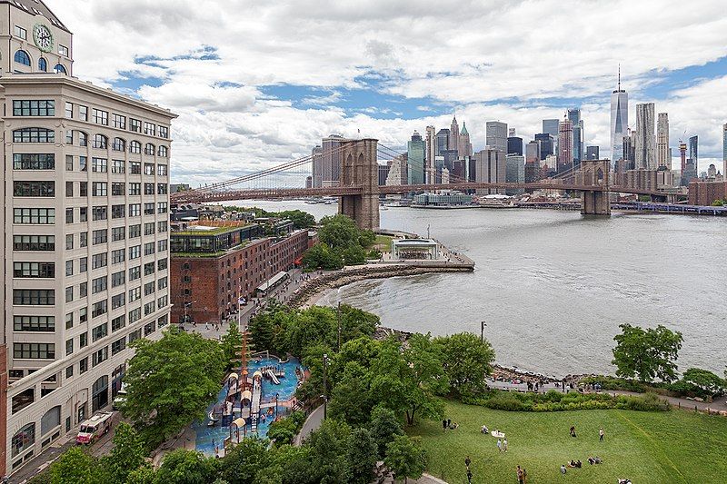
Figure 1. The East River at Brooklyn Bridge Park, 2019. Source: Caroline Culler, “View
of Brooklyn Bridge Park from Manhattan Bridge,” photograph, 28 June 2019.
(https://commons.wikimedia.org/wiki/File:View_of_Brooklyn_Bridge_Park_from_Manhat
tan_Bridge.jpg)
But what of the city’s postindustrial waterfronts that have not gentrified? The South Bronx
shoreline along the Harlem River is one such space. While Bloomberg’s administration courted
environmental gentrification on the East River waterfronts of Queens and Brooklyn, the South
Bronx did not experience a similar transformation. The concept of political ecology posits that
there is an essential relationship between political, economic, and social factors and
environmental issues. Building on this framework, I examine environmental gentrification, or the
lack thereof, as a function of political ecology (Swyngedouw 1996). Postindustrial
1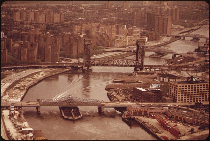
interpretations of the Harlem River’s environment reveal the importance of ideas of nature—
both polluted and reclaimed—in the rebuilding of New York’s waterfront.

         Figure 2. The Harlem River, 1973. Source: Chester Higgins Jr., “HARLEM RIVER—ON LEFT.
         BRONX ON RIGHT,” Photograph from DOCUMERICA: The Environmental Protection
         Agency's Program to Photographically Document Subjects of Environmental Concern,
         compiled 1972–1977, National Archives and Records Administration via Wikimedia
         Commons                          (https://commons.wikimedia.org/wiki/File:HARLEM_RIVER-
         HARLEM_ON_LEFT._BRONX_ON_RIGHT_-_NARA_-_548427.jpg)

     Industrialization disconnected the South Bronx from its waterfront in the mid-nineteenth
century. After one hundred years of commercial shipping and industry along the Harlem, the
decline of New York’s manufacturing economy, containerization, and the shift of port
operations out of the urban core left swaths of the waterfront empty or in junk yards and
nuisance industries; on the South Bronx shoreline, abandonment and deterioration
accompanied this seismic economic shift (City of New York Economic Development
Administration 1972). During the fiscal crisis of the 1970s, city and state planning and economic
development offices surveyed the Harlem looking for potential reinvestment sites on the river.
Yet these surveys reveal that green redevelopment was unimaginable to city planners and
consultants tasked with addressing derelict postindustrial environments (New York City
Planning Commission 1971; New York State Department of Transportation and Energy 1981a).
Ecological consideration is remarkably missing from government reports, suggesting that
environment was invisible to those surveying the South Bronx along the river. In fact, studies of
this area frequently didn’t even include the shore, but stopped two blocks short of it.
   Of the reports from the 1970s and early 1980s, only one state survey offered a
comprehensive overview of Harlem River ecology, yet it also paradoxically exacerbated the
denial of the river as a natural environment and the disconnect between riverine nature and the
abutting community. A century of landfill and dumping had decimated the Harlem’s ecosystem

                                                    2
(City of New York Economic Development Administration 1972). In 1981, the State Department
of Transportation’s Rail Division declared the only resources of any historic nature on the
Harlem waterfront were the bulkheads, riprap, boat slips, and buildings that stood as a “record
of man's exploitation of his environment.” The river had been “so altered by intense residential
and commercial development that it preclude[d] any meaningful discussion. Flora of the area
[was] practically non-existent with the exception of a few trees generally found in urban areas
and shrub growth” (New York State Department of Transportation and Energy 1981b, 1).
Researchers resolved there was not sufficient evidence of flora or maritime life to recommend
ecological preservation or even remediation. The material nature of the Harlem had been
negated by human impact; the tacit assumption behind the state report was that nature could
not coexist with the level of industrial development—even after industry left the area.
Communities along the postindustrial Harlem continue to endure waterfront degradation in
the twenty-first century. The South Bronx shore hosts four power plants, two waste transfer
sites, an oil storage facility, and a medical waste incinerator. Activist Raymond Figueroa, who
leads canoeing trips on the river, explained that his tours “involve launching [covertly] because
there are no canoe or kayak launches… in this … section of the South Bronx…[it] is a
concentration of industrial facilities that are actually blocking the community’s access to the
waterfront. He calls this lack of access “an environmental justice issue. You look at…Brooklyn
Bridge Park…where there [is] access, there are opportunities for access to the waterfront. That
is not the case in this community which is sharing a disproportionate burden of environmental
justice burdens in terms of waste management facilities sitings, industrial sitings, and the
configuration of transportation infrastructure” (Figueroa 2017). Green amenities increasingly
characterize the East River; Brooklyn Bridge Park abounds with lawns and native flora. Along
the Harlem River fences, concrete, and industrial sites, not a rebuilt coastal ecosystem,
dominate the shore.
Historian Ann L. Buttenweiser marks the 1990s as the crucial turning point when waterfront
redesign became “cannon” for Manhattan (Buttenweiser 1999). This timeline does not fit the
coastal history of the South Bronx. In 1991, New York State offered a developer a ninety-nine-
year lease for an abandoned waterfront railyard. A waste transfer station, a fossil fuel power
plant, a newspaper printing and distribution centers, a trucking shipping center went up—these
are the spaces Figueroa spoke about. Barretto Point Park, on the far side of this industrial
complex, opened in 2006 as the area’s only waterfront park. In 2015, a pedestrian bridge
spanning the Bronx Kill, an arm of the Harlem, to Randall’s Island, marking the second
opportunity to access green space for South Bronxites (Marton and Peterson 2015; New
Yorkers for Parks 2014). The island was the path of least resistance, offering park access without
having to address Harlem River accessibility (City of New York Economic Development
Administration 1972). The longstanding erasure of nature and public access from the riverfront
stands in stark relief with the neoliberal environmental gentrification of twenty-first century
Brooklyn—this is the environmental injustice Figueroa saw when he paddled the Harlem.
Environmental gentrification signals a rethinking of urban coastal nature by politicians and
planners: under New York City’s dominant political ecology, nature-as-amenity repurposes the
environment as a tool of capital creation (Banzhaf and McCormick 2012). The city’s engines of
wealth and power in the early twenty-first century rediscovered the value of “green”
3waterfronts. But only for certain parts of the city—for certain populations and districts that
interest large-scale developers. The Harlem remains largely unreachable and degraded. The
paradox of environmental injustice in the era of environmental gentrification remains
unresolved on the postindustrial waterfront.
References
Banzhaf, H. Spencer, and Eleanor McCormick. 2012. “Moving Beyond Cleanup: Identifying the
Crucibles of Environmental Gentrification.” In The Political Economy of Environmental
Justice, edited by H. Spencer Banzhaf, 24–25. Stanford: Stanford University Press.
Barrett, Sarah Hayley. 2016. “The Long Awaited Waterfront.” WNYC, December 21, 2016.
http://www.wnyc.org/story/long-awaited-waterfront.
Buttenweiser, Ann L. 1999. Manhattan Water-Bound: Planning and Developing Manhattan’s
Waterfront from the Seventeenth Century to the Present. Syracuse: Syracuse University
Press.
City of New York Economic Development Administration and Marcou, O’Leary and Associates.
1972 “South Bronx-Harlem River Yards: Harlem River Yards Site Development: A Study to
Establish the Feasibility of Industrial Development.” Washington: np.
Figueroa, Raymond. 2017. “ID: APP354469.” Interview by Rebecca Pryor. Story Corps.Org.
Accessed July 2018. https://archive.storycorps.org/interviews/ray-at-brook-park/.
Marton, Deborah, and Casey Peterson. 2015. The Haven Project. New York Restoration Project.
Accessed August 2018. https://www.nyrp.org/NYRP_TheHavenProject_alt_(2).pdf.
New York City Department of Planning. 2011. “Mayor Bloomberg and Speaker Quinn Unveil
Comprehensive Plan for New York City’s Waterfront And Waterways.” Last modified March
14, 2011. https://www1.nyc.gov/assets/planning/download/pdf/about/press-
releases/pr031411.pdf.
New Yorkers for Parks. 2014. “Mott Haven Open Space Index.” New Yorkers 4 Parks. Accessed
July 2018. http://www.ny4p.org/client-
uploads/pdf/OSI/NY4P_Mott_Haven_Open_Space_Index.pdf.
New York State Department of Transportation and Energy & Environmental Analysts, Inc.
1981a. “South Bronx-Oak Point Link, Environmental Impact Statement Technical Support
Document No. 3 Cultural Resources Inventory.” New York State Department of
Transportation. Accessed August 2018. http://s-
media.nyc.gov/agencies/lpc/arch_reports/35.pdf.
New York State Department of Transportation and Energy & Environmental Analysts, Inc.
1981b. “South Bronx-Oak Point Link, Environmental Impact Statement Technical Support
Document No. 2 Description of Existing Conditions: Terrestrial Ecology, Aquatic Ecology,
and Water Quality.” New York State Department of Transportation. Accessed September
2018. https://play.google.com/books/reader?id=AvI3AQAAMAAJ&pg=GBS.PA1.
4New York City Planning Commission. 1971. “Hunts Point Industrial District: Economic
Development Section Interim Report.” New York: New York City Planning Commission.
Swyngedouw, Erik. 1996. “The City as a Hybrid: On Nature, Society and Cyborg Urbanization.”
Capitalism Nature Socialism 7 (2): 65–66.
5You can also read